Ecological dynamics
This site is on mid flood plains dissected by a deep river channel. Local site factors including local flooding and ponding dynamics and soil characteristics support three co-occurring plant communities. The reference plant community is an open tall scrubland (Viereck et al., 1992). Plant species are facultative to obligate wetland species resistant to occasional ponding and flooding. Common species are also tolerant of the poorly developed soils associated with this site.
Spatial and temporal patterns in hydrology support three flood plain communities. Flooding intensity and frequency are critical in the distribution and abundance of vegetation in Alaskan riverine systems (Wohl, 2007). Flooding can lead to plant succession by creating barren, moist areas for colonization, burying organic layers, adding nutrients to the soil, and depositing seed banks (Rood et al., 2007; Yarie et al., 1998). Areas near the river channel that are more prone to scouring from flooding and ice bulldozing than distal areas. Lower areas support a higher water table and are more prone to longer periods of ponding. Better drained areas with lower water tables further typically support the reference plant community. Areas with high water tables that experience soil scouring and sediment deposition are more likely to support community 1.3. Community 1.2 is an intermediate assemblage.
Changes in site hydrology due to shifts in the water table and flooding and ponding frequency and duration may affect plant composition. Scouring and sediment deposition can transform an existing community to community 1.3. Decreased flooding pressure and subsequent ponding can allow an older community to develop, eventually reaching the reference plant community. These changes are slow. Annual changes in precipitation or flow rate are likely to affect site hydrology.
Slight to severe browsing of willows and forbs by moose in summer occurs in the reference community phase. Browsing does not significantly affect the structure and function of the reference community phase or the ecological site.
Beaver-affected areas are described by an alternate state. In these areas, hydrophilic forbs, graminoids, and willows typically surround beaver ponds and upstream areas. It is unknown if the pond will naturally return to the reference state after dam removal.
The information in this Ecological Dynamics section, including the state-and-transition model (STM), was developed based on current field data, professional experience, and a review of the scientific literature. As a result, all possible scenarios or plant species may not be included. Key indicator plant species, disturbances, and ecological processes are described to inform land management decisions.
State 1
Reference State
The reference state supports three community phases, which are grouped by the structure and dominance of the vegetation (e.g., graminoids, shrubs, and forbs) and by their ecological function and stability. The presence of these communities is temporally dictated by the occasional periods of flooding. The reference community phase is represented by open scrubland that has graminoids and forbs throughout. A transition to an alternate state is caused by the damming of a nearby waterway by beavers (Castor canadensis).
Community 1.1
Bluejoint grass/fireweed-purple marshlocks/tealeaf willow-feltleaf willow scrubland

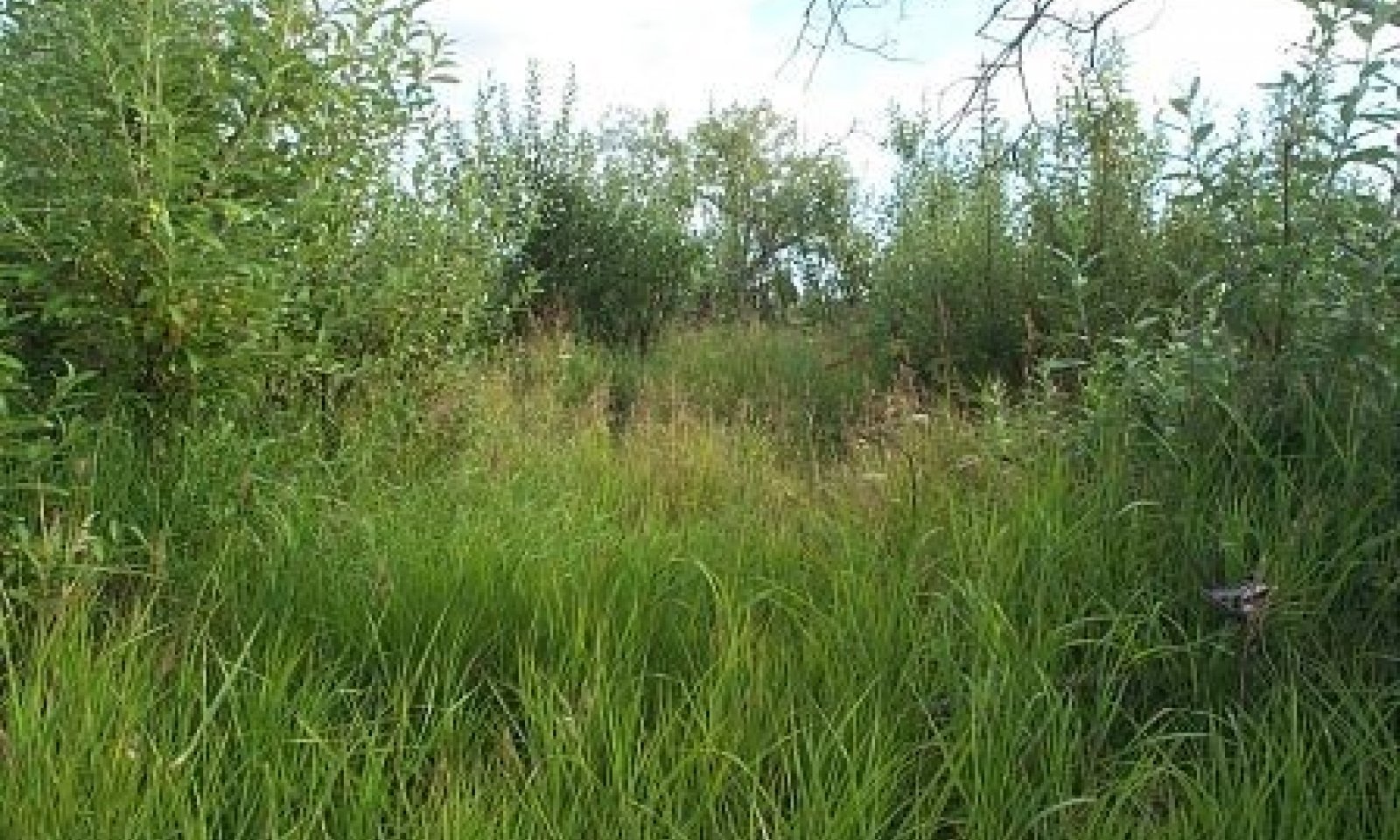
Figure 8. Typical area of community 1.1.
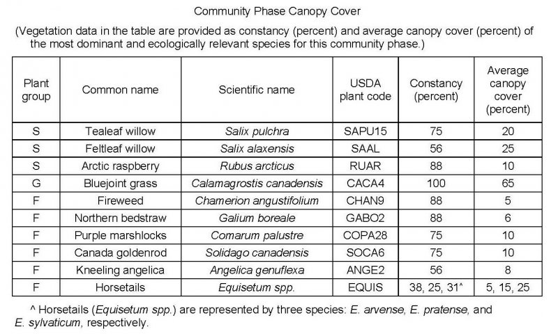
Figure 9. Constancy and canopy cover of plants in community 1.1.
The reference community phase is characterized by open willow scrubland that has areas of grass and diverse forbs throughout. Typically, this community phase consists of patchy medium and tall tealeaf willow (Salix pulchra) and feltleaf willow (Salix alaxensis) and open areas of bluejoint grass (Calamagrostis canadensis), arctic raspberry (Rubus arcticus), and various forbs, including fireweed (Chamerion angustifolium), purple marshlocks (Comarum palustre), and northern bedstraw (Galium boreale). Other species may include tall Jacob’s-ladder (Polemonium acutiflorum), kneeling angelica (Angelica genuflexa), Canada goldenrod (Solidago canadensis), fewflower meadow-rue (Thalictrum sparsiflorum), and horsetails (Equisetum spp.). Individual trees in the medium stratum or regenerative trees, including balsam poplar (Populus balsamifera), paper birch (Betula papyrifera), and white spruce (Picea glauca), may be present. Mosses commonly are in the ground cover (about 30 percent total mean cover). Other ground cover generally includes herbaceous litter (about 80 percent cover) and woody litter (about 4 percent).
Community 1.2
Bluejoint grass/arctic raspberry/Canada goldenrod-northern bedstraw/willow grassland
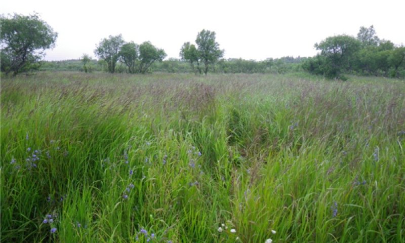
Figure 10. Typical area of community 1.2.
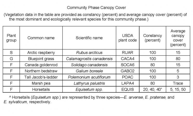
Figure 11. Constancy and canopy cover of plants in community 1.2.
The late flooding community phase is characterized by grassland that has various forbs throughout. Typically, this community consists dominantly of dense bluejoint grass (Calamagrostis canadensis) with arctic raspberry (Rubus arcticus) and scattered forbs throughout. Forbs may include northern bedstraw (Galium boreale), tall Jacob’s-ladder (Polemonium acutiflorum), Canada goldenrod (Solidago canadensis), marsh pea (Lathyrus palustris), and horsetails (Equisetum spp.). Mosses generally are in the ground cover (about 25 percent total mean cover). The ground cover commonly includes herbaceous litter (about 90 percent) and woody litter (about 2 percent). About 15 percent is bare soil.
Community 1.3
Canada goldenrod-woodland horsetail-northern bedstraw-fireweed/bluejoint grass meadow
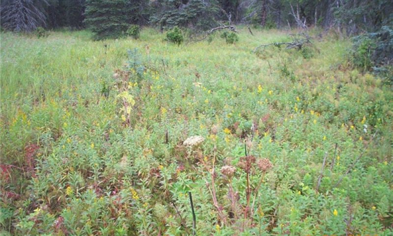
Figure 12. Typical area of community 1.3.
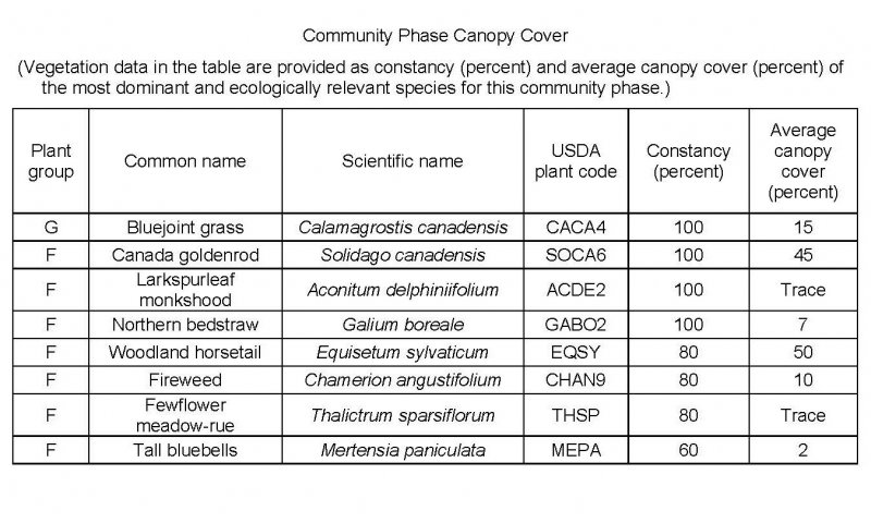
Figure 13. Constancy and canopy cover of plants in community 1.3.
The early flooding community phase is characterized by a forb meadow that has interspersed graminoids. Typically, this community consists of various forbs such as Canada goldenrod (Solidago canadensis), northern bedstraw (Galium boreale), woodland horsetail (Equisetum sylvaticum), and fireweed (Chamerion angustifolium) with bluejoint grass (Calamagrostis canadensis) throughout. Rough bentgrass (Agrostis scabra), arctic raspberry (Rubus arcticus), larkspurleaf monkshood (Aconitum delphiniifolium), fewflower meadow-rue (Thalictrum sparsiflorum), and tall bluebells (Mertensia paniculata) may be present. Mosses generally are in the ground cover (about 65 percent total mean cover). The ground cover also commonly includes herbaceous litter (about 65 percent) and a trace of woody litter. Areas of bare soil typically are present. Individual trees in the medium stratum and regenerative trees may be in this community, particularly in areas adjacent to forested or woodland ecological sites that are not affected by flooding.
Pathway 1.1a
Community 1.1 to 1.3
Bluejoint grass/fireweed-purple marshlocks/tealeaf willow-feltleaf willow scrubland
Canada goldenrod-woodland horsetail-northern bedstraw-fireweed/bluejoint grass meadow
Flooding scours vegetation and soil. Post-flood sites are bare and are ideal for fast growing, hydrophytic forbs and graminoids. Additionally, a raised water table stresses extant species of the reference plant community. Less tolerant species die back to be replaced by more tolerant forbs and graminoids. Water table increases are the result of increased water input to an area. This could be caused by increased precipitation, including more snow during the winter or more rain during the growing season. A raised water table could also be a result of an upstream disturbance such as a fire, which increases run off rates.
Pathway 1.2a
Community 1.2 to 1.1
Bluejoint grass/arctic raspberry/Canada goldenrod-northern bedstraw/willow grassland
Bluejoint grass/fireweed-purple marshlocks/tealeaf willow-feltleaf willow scrubland
A lowered water table allows less resilient, slower growing species to colonize. A lowered water table could be a result of a decrease in precipitation, a decrease in upstream run off into the site or improved drainage in the flood plain site.
Pathway 1.2b
Community 1.2 to 1.3
Bluejoint grass/arctic raspberry/Canada goldenrod-northern bedstraw/willow grassland
Canada goldenrod-woodland horsetail-northern bedstraw-fireweed/bluejoint grass meadow
A raised water table stresses extant species. Less tolerant species die back to be replaced by more tolerant wetland forb and graminoid species. Increased water input to an area raises the water table. This can be caused by increased precipitation, including more snow during the winter or more rain during the growing season. A raised water table could also be a result of an upstream disturbance such as a fire, which increases run off rates.
Pathway 1.3a
Community 1.3 to 1.2
Canada goldenrod-woodland horsetail-northern bedstraw-fireweed/bluejoint grass meadow
Bluejoint grass/arctic raspberry/Canada goldenrod-northern bedstraw/willow grassland
A lowered water table allows less resilient, slower growing species to colonize. A lowered water table could be a result of a decrease in precipitation, a decrease in upstream run off into the site or improved drainage in the flood plain site.).
State 2
Beaver-Affected Areas
This alternate state results from ponding near beaver dams. Beavers (Castor canadensis) directly kill trees and large shrubs for food and dam construction, and they also indirectly kill these species and others by causing a rise in the water table (USDA–FS, 2013). Ponding of the site results in a plant community different from that normally on these flood plains. This alternate plant community commonly includes resilient individuals and extant species in the reference community phase as well as pioneer hydrophilic species. The permanent ponding associated with areas upstream from beaver dams can negate the influence of flooding on the soils and vegetation. The plant community likely will remain relatively stable until the dam is removed. When the dam is removed by natural blowout, abandonment by beaver, or human intervention, the plant community likely will revert back to the reference state. Further research is needed to quantify this process in situ.
Browsing of willow by moose may be severe. This may maintain the open scrubland by preventing willows from becoming dominant in the community.
Community 2.1
Tealeaf willow/bluejoint grass-Northwest Territory sedge/purple marshlocks-water horsetail open scrubland
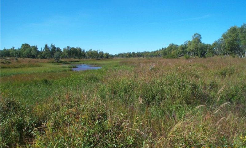
Figure 14. Typical area of community 2.1.
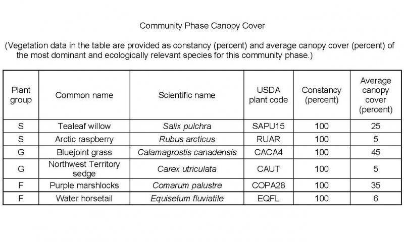
Figure 15. Constancy and canopy cover of plants in community 2.1.
This community phase is associated with areas surrounding beaver ponds. It is characterized by open scrubland that has facultative or obligate graminoids and forbs throughout. Typically, the community consists of patchy tealeaf willow (Salix pulchra) and ubiquitous bluejoint grass (Calamagrostis canadensis), Northwest Territory sedge (Carex utriculata), purple marshlocks (Comarum palustre), and water horsetail (Equisetum fluviatile). Other species include silvery sedge (Carex canescens), Lyngbye’s sedge (Carex lyngbyei), cottongrasses (Eriophorum spp.), arctic raspberry (Rubus arcticus), and Mackenzie’s water hemlock (Cicuta virosa). The ground cover commonly consists of mosses, herbaceous litter, and woody litter. Areas of open water and bare soil generally are present.
Note: The vegetation and soils for this plant community phase were sampled at one location. Due to the limited data available, personal field observations were used to aid in describing this plant community.
Transition T1A
State 1 to 2
Beaver ponds raise the upstream water table and increase ponding length and depth in affected areas. Flooding is less likely to be disruptive to the vegetation.
Constraints to recovery. It is currently unknown whether the removal of a beaver population and the associated network of dams will restore an drainage to the reference state.
Restoration pathway R2A
State 2 to 1
It is unknown if the alternate state will naturally return to the reference states natural upon removal of a beaver dam. Various factors, such as site hydrology, extant species, propagule pressure, will influence the restoration pathway. Further research and in situ documentation is needed to fully describe this transition.
