
Natural Resources
Conservation Service
Ecological site R236XY135AK
Western Alaska Maritime Scrub Loamy Plains, Coastal
Last updated: 2/13/2024
Accessed: 12/21/2025
General information
Provisional. A provisional ecological site description has undergone quality control and quality assurance review. It contains a working state and transition model and enough information to identify the ecological site.
MLRA notes
Major Land Resource Area (MLRA): 236X–Bristol Bay-Northern Alaska Peninsula Lowlands
The Bristol Bay-Northern Alaska Peninsula Lowlands Major Land Resource Area (MLRA 236) is in southwest Alaska. It covers 19,575 square miles (USDA–NRCS, 2006) and extends inland from Bristol Bay. It is composed primarily of level to rolling plains and low to moderate hills bordered by long footslopes of mountains (Kautz et al., 2012). The flood plains and terraces along the major rivers and lakes are characterized by depressions and small basins. Mountains form the eastern and western borders of the MLRA, and glacially formed lakes are behind terminal moraines (Kautz et al., 2012). The entire MLRA was covered by glacial ice during the early to middle Pleistocene (USDA–NRCS, 2006).
The climate near the coast is dominantly maritime, and the climate farther inland is continental and is influenced by weather systems of Interior Alaska (Kautz et al., 2012). Summers typically are warm and short, and winters are long and cold. The average annual precipitation is 13 to 50 inches, and the average annual air temperature is 30 to 36 degrees F (Kautz et al., 2012). The freeze-free period normally is 70 to 125 days. Aspect and elevation, which ranges from sea level to about 2,500 feet above sea level (USDA–NRCS, 2006), influence the climate and weather patterns.
This MLRA is sparsely populated. The major communities include Dillingham, Naknek, and King Salmon. Federally managed land in the MLRA includes parts of Katmai National Park and Preserve and the Aniakchak National Monument and Preserve as well as Togiak and Alaska Peninsula National Wildlife Refuges (Kautz et al., 2012; USDA–NRCS, 2006).
Ecological site concept
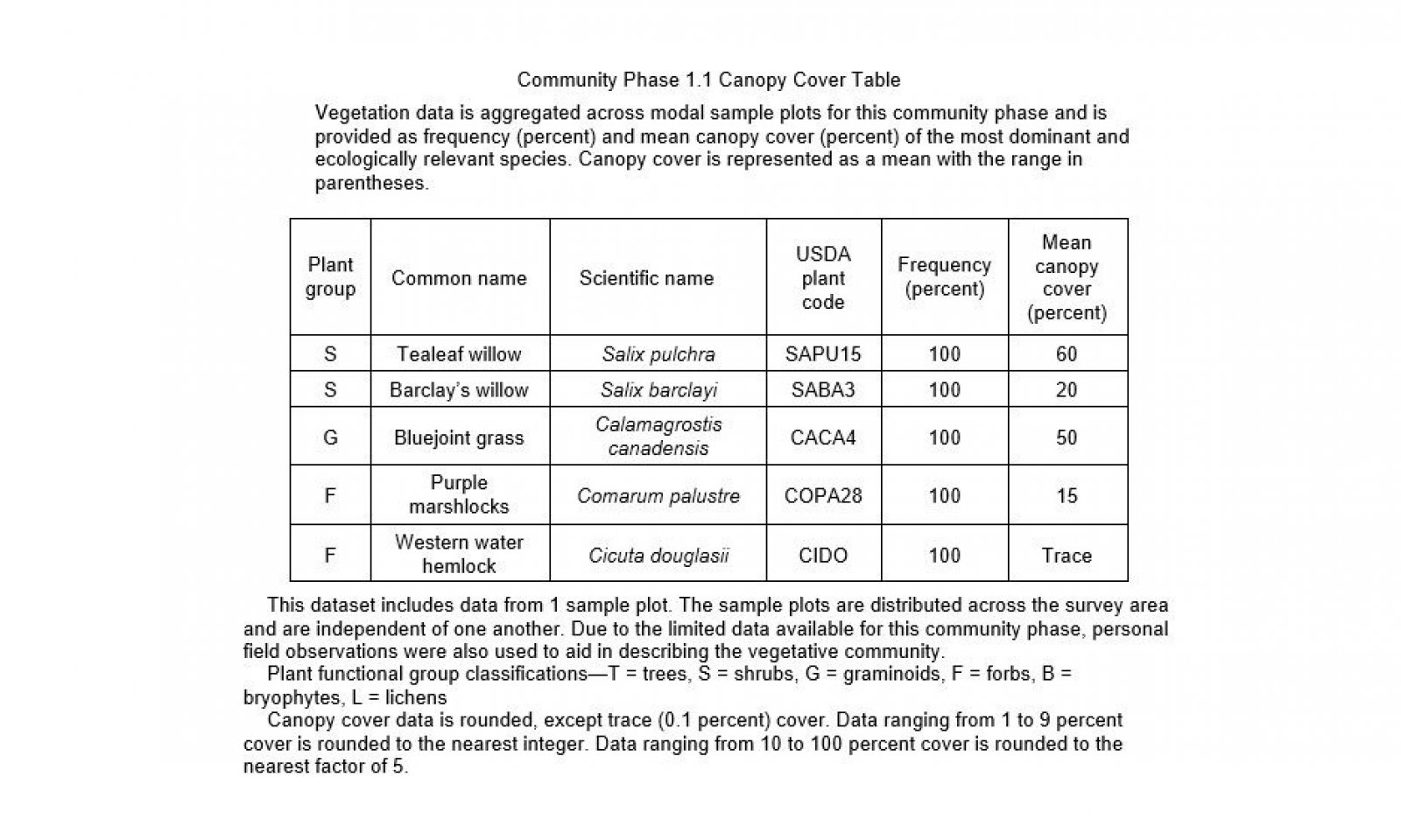
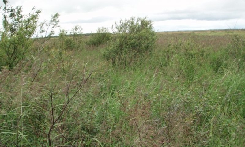
Site R236XY135AK is along tidal gluts of coastal plains. The unique hydrologic processes, including ponding, flooding, and a high water table, produce a unique combination of soils and vegetation. The reference plant community is closed low scrubland (Viereck et al., 1992) that consists of willow, bluejoint, and various forbs.
Associated sites
| R236XY129AK |
Subarctic Low Scrub Peat Coastal Plains Several other ecological sites are also on the lowland coastal plains in MLRA 236, including site R236XY129AK (Western Alaska Maritime Scrub Peat Plains, Coastal). Site R236XY135AK is the only one adjacent to tidal guts and it does not have silt, gravel, or water on the surface; therefore, unique ecological sites are needed. |
|---|---|
| R236XY133AK |
Subarctic Graminoid Loamy Tidal Coastal Plains Several other ecological sites are also on the lowland coastal plains in MLRA 236, including site R236XY133AK (Western Alaska Maritime Graminoid Loamy Plains, Coastal). Site R236XY135AK is the only one adjacent to tidal guts and it does not have silt, gravel, or water on the surface; therefore, unique ecological sites are needed. |
| R236XY170AK |
Subarctic Graminoid Loamy Coastal Plain Rises Several other ecological sites are also on the lowland coastal plains in MLRA 236, including site R236XY170AK (Western Alaska Maritime Graminoid Gravelly Plains, Coastal). Site R236XY135AK is the only one adjacent to tidal guts. Sites R236XY135AK and R236XY170AK do not have silt, gravel, or water on the surface. Site R236XY135AK is at lower elevations and the soil is less easily drained; therefore, it is wetter than site R236XY170AK and supports facultative or obligate wetland plants that are not in site R236XY170AK. Unique ecological sites are needed. |
Table 1. Dominant plant species
| Tree |
Not specified |
|---|---|
| Shrub |
(1) Salix pulchra |
| Herbaceous |
(1) Calamagrostis canadensis |
Click on box and path labels to scroll to the respective text.
Ecosystem states
State 1 submodel, plant communities
| 1.1A | - | Increased hydrological pressures. |
|---|---|---|
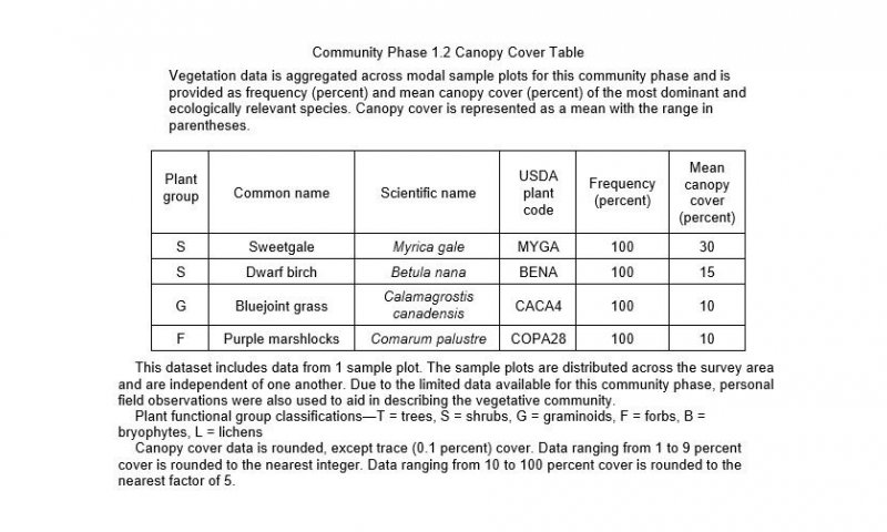
| 1.2A | - | Decreased hydrological influences. |


