Ecological dynamics
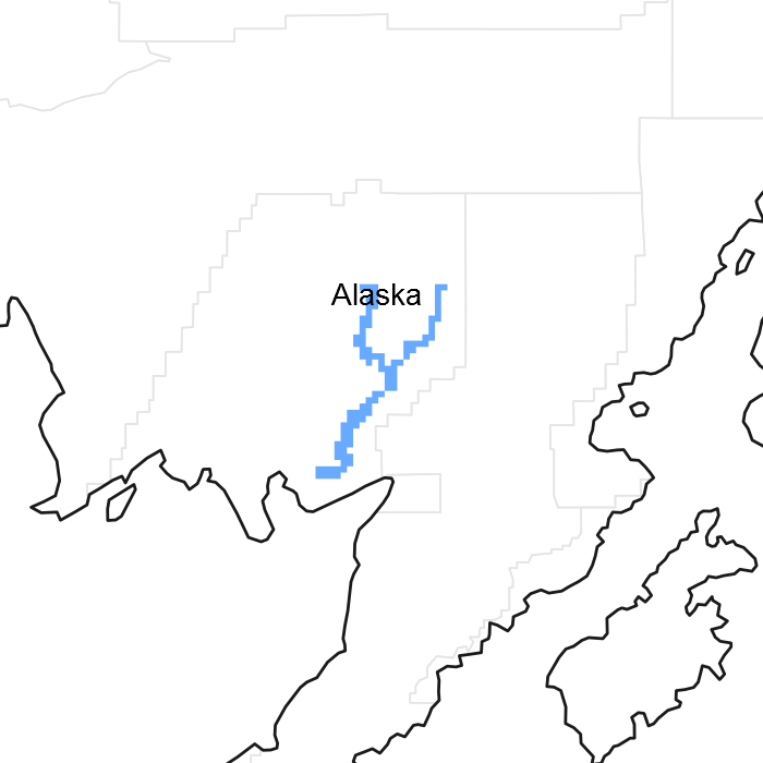
This boreal ecological site is in channels of mid flood plains of the Nushagak River. Elevation ranges from sea level to 580 feet above sea level, and slopes are 0 to 1 percent. Slope aspect does influence the plant community dynamics of this site.
This ecological site is correlated to D36-Boreal scrub silty flood plains, wet. This soil has a cryic temperature regime and an aquic moisture regime. The saturated hydraulic conductivity is moderately low to a depth of 40 inches. The upper mineral horizon is very strongly acid or strongly acid (pH 4.8 to 5.3), and it has an organic matter content of 50 to 100 percent. The soil is poorly drained. The annual precipitation is 24 to 37 inches, and the annual frost-free period is 85 to 140 days. The parent material consists of herbaceous organic material over coarse-silty alluvium.
The reference community phase is typified by tall scrubland consisting of alder and willow and an understory of diverse forbs and bluejoint grass (Calamagrostis canadensis). All of the ecological sites on boreal mid flood plains in the MLRA are subject to flooding, but this site is also subject to frequent, long periods of ponding. Differences in soil moisture and disturbance regimes create distinct reference states and community phases, making the use of unique ecological sites necessary.
Ponding is the major documented disturbance regime for this ecological site; it is considered natural and typically is unmanaged. This disturbance regime results in two distinct community phases. Although this site is subject to occasional, long periods of flooding, the ponding affects the progression of vegetation in the community phases. The site is subject to frequent, long periods of ponding in April through October because of the depressed topography, minimal slope, and poorly drained soils. A water table is near the surface during peak snowmelt in May and June. The available background information suggests that ponding commonly inhibits oxygen to susceptible plants (Hook and Crawford, 1978; Jackson et al., 1991). The hypoxic or anoxic condition is a major abiotic stress that may determine the presence or absence of vascular plants (Vartapetian and Jackson, 1996). The period of ponding that affects plants varies. Temporal tolerance of plants to oxygen deprivation differs among species and may range from many hours to several weeks (Vartapetian and Jackson, 1996). The effects of ponding typically depend on the periods of flooding and the yearly and monthly deviations in rainfall, snowmelt, and seepage.
Moderate or severe browsing by moose on willows has been observed in both community phases. Browsing appears to cause patchiness in the stands of willow and alder, which may partially explain the variation in the willow cover in the reference community phase. Browsing appears to be ubiquitous, but it does not create a significant change in the structure and function of the communities.
State 1
Reference State
The reference state supports two community phases, which are grouped by the structure and dominance of the vegetation (e.g. shrubs, graminoids, and forbs) and by their ecological function and stability. The presence of these communities is dictated temporally by ponding. The reference community phase is characterized by scrubland that has graminoids and forbs throughout. No alternate states have been observed.
Community 1.1
Sitka alder-tealeaf willow-feltleaf willow/bluejoint grass/purple marshlocks-horsetails scrubland
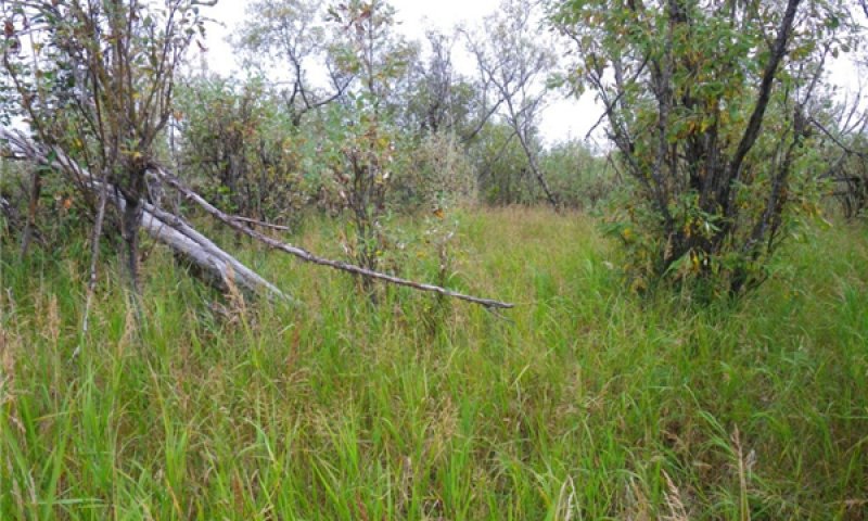
Figure 2. Typical area of community 1.1.
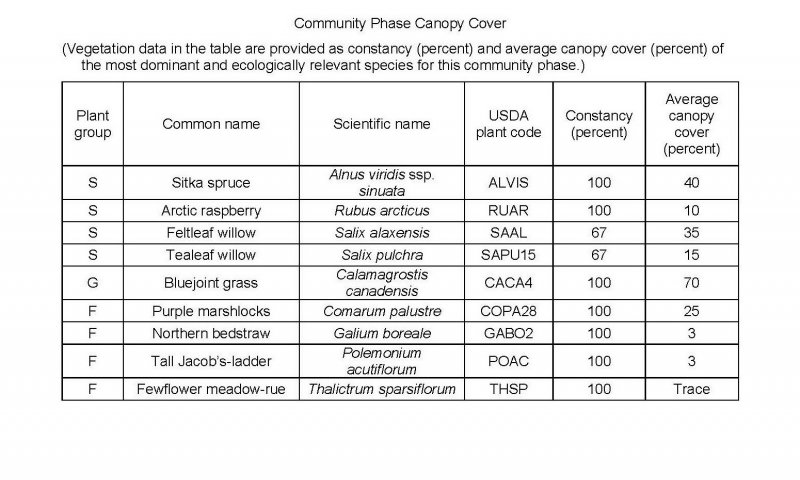
Figure 3. Constancy and canopy cover of plants in community 1.1.
The reference community phase is characterized by scrubland that has bluejoint grass (Calamagrostis canadensis) and forbs throughout the understory and in open spaces. Typically, this community consists of a mixed scrubland of Sitka alder (Alnus viridis ssp. sinuata), tealeaf willow (Salix pulchra), and feltleaf willow (Salix alaxensis) and an understory of bluejoint grass (Calamagrostis canadensis), purple marshlocks (Comarum palustre), northern bedstraw (Galium boreale), and violets (Viola spp.). Other species may include arctic raspberry (Rubus arcticus), tall Jacob’s-ladder (Polemonium acutiflorum), fewflower meadow-rue (Thalictrum sparsiflorum), and various sedges (Carex spp.). Rare, individual, medium or regenerating Kenai birch (Betula papyrifera var. kenaica) trees are present, but the natural disturbance regime prevents development of woodland or forestland. Mosses are common in the ground cover (about 40 percent total mean cover), dominantly sphagnum mosses (Sphagnum spp.) and rhizomnium mosses (Rhizomnium spp.). Other ground cover commonly includes herbaceous litter (about 60 percent cover) and woody litter (about 3 percent). About 1 percent of the surface is covered with water.
Note: The vegetation and soils for this community were sampled at three locations. Due to the limited data available, personal field observations were used to aid in describing the plant community.
Community 1.2
Tealeaf willow/bluejoint grass-Northwest Territory sedge/purple marshlocks open scrubland
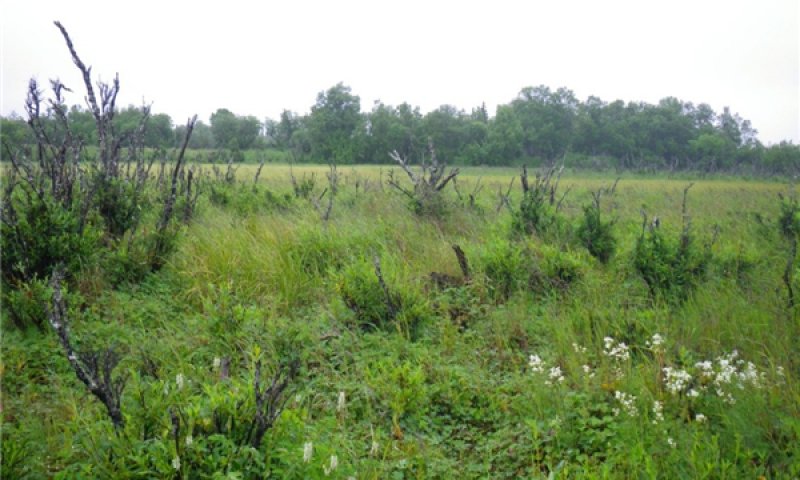
Figure 4. Typical area of community 1.2.
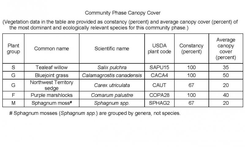
Figure 5. Constancy and canopy cover of plants in community 1.2.
The early ponding community phase is characterized by open scrubland that has hydrophilic graminoids and forbs throughout the understory and in open areas. Typically, this community consists of clusters of tealeaf willow (Salix pulchra) with bluejoint grass (Calamagrostis canadensis), Northwest Territory sedge (Carex utriculata), and purple marshlocks (Comarum palustre) throughout. Other common species include alder (Alnus spp.), arctic raspberry (Rubus arcticus), field horsetail (Equisetum arvense), fireweed (Chamerion angustifolium), threepetal bedstraw (Galium trifidum), and Canadian burnet (Sanguisorba canadensis). Mosses generally are in the ground cover (about 20 percent total mean cover), including sphagnum mosses (Sphagnum spp.). The ground cover also includes herbaceous litter (about 75 percent cover) and woody litter (about 1 percent). About 5 percent of the surface is covered by water. About 1 percent is bare soil.
Note: The vegetation and soils for this community were sampled at three locations. Due to the limited data available, personal field observations were used to aid in describing the plant community.
Pathway 1.1a
Community 1.1 to 1.2
Sitka alder-tealeaf willow-feltleaf willow/bluejoint grass/purple marshlocks-horsetails scrubland
Tealeaf willow/bluejoint grass-Northwest Territory sedge/purple marshlocks open scrubland
Ponding.
This ecological site is subject to extended periods of ponding because of the minimal slopes and channeled topography. Ponding and saturation of the soils can create hypoxic and anoxic conditions that can stress or drown susceptible plants. The decreased competition for space and light can allow hydrophilic pioneer plants to colonize and the surviving graminoids to increase in abundance.
The site is subject to frequent, long periods of ponding in April through October. It is hypothesized that much longer periods of ponding are needed to drown extant shrubs in the reference community phase and cause a community transition from the reference community phase to the early ponding phase (community 1.2).
Pathway 1.2a
Community 1.2 to 1.1
Tealeaf willow/bluejoint grass-Northwest Territory sedge/purple marshlocks open scrubland
Sitka alder-tealeaf willow-feltleaf willow/bluejoint grass/purple marshlocks-horsetails scrubland
Natural succession: Normal time and growth without disruptive ponding.
As ponding subsides over time, facultative wet or obligate species will become less competitive and existing populations of species that are less water tolerant will increase. This commonly includes an increase in species that have greater longevity, such as shrubs. The canopy may increase the number of available niches and lead to an increase in the richness of shrubs, graminoids, and forbs. The period needed for this transition currently is unknown. It likely begins when active ponding ceases and is partially determined by the rates of propagule spread and growth of shrubs.


