Natural Resources
Conservation Service
Ecological site AX001X02X003
Mesic Aquic Forest
Last updated: 1/23/2025
Accessed: 01/15/2026
General information
Provisional. A provisional ecological site description has undergone quality control and quality assurance review. It contains a working state and transition model and enough information to identify the ecological site.
MLRA notes
Major Land Resource Area (MLRA): 001X–Northern Pacific Coast Range, Foothills, and Valleys
This long and narrow resource area stretches along the Pacific Border Province of the Pacific Mountain System in Oregon and Washington. The area is bounded by the Olympic Mountains on the north and the Klamath Mountains on the south. Most of the area consists of hills and low mountains with gentle to steep slopes. The parent materials are composed primarily of young Tertiary sedimentary rocks with some minor volcanic rocks. Glacial till and outwash deposits are found in the northern half of the area within Washington. In the far southern portion of the area, near the Klamath Mountains, the sedimentary rocks are older and some have been metamorphosed. The average annual precipitation ranges from 60 to 200 inches, increasing with elevation.
The dominant soil orders in this MLRA are Andisols, Inceptisols, and Ultisols. Soil depth ranges from shallow to very deep. While most soils in the area are well drained and occur on foothills, mountain slopes and ridges, floodplain and depressional soils can range from well drained to very poorly drained. Soil textures are typically medial, loamy, or clayey. The dominant soils in the area have a mesic or frigid soil temperature regime and a udic soil moisture regime; however, soils with an aquic soil moisture regime or cryic soil temperature regime do occur.
LRU notes
The North Pacific Coast Range land resource unit (LRU 2) of MLRA 1 is located in the northwestern corner on the Olympic Peninsula and within the Olympic National Forest in Washington State. LRU 2 is bounded on the west by MLRA 4a Sitka Spruce Belt and MLRA 2 Willamette and Puget Sound Valleys to the east. LRU 2 encircles the Olympic National Park (LRU 1). Several major rivers have headwaters in this LRU or carved valleys through the landscape depositing more recent alluvium. These include the Duckabush, Elwha, Queets, Quinault, Skokomish, Sol Duc, and Wynoochee Rivers.
Ecological site concept
This ecological site is found on the western Coast Range in the Pacific Northwest from southern Washington to northern Oregon. It is located at low elevations (less than 1,500 ft.) with abundant precipitation. It consists of forested wetlands in depressions, on terraces, and in seeps of mountain slopes that have a seasonal high water table. The site is strongly influenced by physiography and hydrology, which provide rare and unique habitats in the coastal range.
The climate has warm, moist summers and cool, wet winters. Mean annual precipitation ranges from 40 to 110 inches and occurs mostly as rain, when snow occurs it does not persist. Average annual temperatures range from 48 to 52 degrees F.
Soils that support this ecological site are in the mesic soil temperature regime and aquic soil moisture regime. This site is subject to residual ponding or a seasonal high water table. The water table commonly is at or near the surface much of the growing season, and the rate of organic decomposition is slow due to anaerobic conditions. The seasonal high water table and ponding dynamics may be altered by artificial drainage of the site or adjacent areas. A thin organic horizon consisting of decomposing twigs, needles, and litter is on the surface, which helps to protect the soils from wind and water erosion.
The most common overstory species are western hemlock (Tsuga heterophylla), western redcedar (Thuja plicata), Douglas-fir (Pseudotsuga menziesii), Cascara buckthorn (Frangula purshiana), bigleaf maple (Acer macrophyllum), and red alder (Alnus rubra). As a result of soil saturation during much of the year, conifers may be restricted to nurse logs or higher microsites and they commonly are short and stunted (Roccio, 2015). Shrubs may be sparse or entirely absent in some areas. Shrubs may include salmonberry (Rubus spectabilis), devilsclub (Oplopanax horridum), Alaska huckleberry (Vaccinium alaskaense), vine maple (Acer circinatum), red huckleberry (Vaccinium parvifolium) and salal (Gaultheria shallon). The herb layer commonly is dominantly American skunkcabbage (Lysichiton americanus), threeleaf foamflower (Tiarella trifoliata), small enchanter’s nightshade (Circaea alpina), ladyfern (Athyrium filix-femina), deer fern (Blechnum spicant), and slough sedge (Carex obnupta).
The most common natural disturbance is ponding. The volume and longevity of the ponding determine the effect on the dynamics of the forest. The site is vulnerable to windthrow following large coastal storms. Trees in this site are particularly susceptible to windthrow due to the shallow rooting depth in response to the seasonal high water table and long periods of ponding that extend into the growing season. Fallen trees that have exposed root systems and large woody debris are common. The fallen trees result in more canopy openings. The openings allow more sunlight to reach the forest floor, which leads to a shrubby understory. Disturbances in adjacent areas may alter the hydrology and increase the susceptibility to infestation by invasive species.
Associated sites
| AX001X02X001 |
Mesic Udic Riparian Forest Ecological Site AX001X02X003, Mesic Aquic Forest is typically located adjacent to Ecological Site AX001X02X001, Mesic Udic Riparian Forest. Mesic Aquic Forest is located on alluvial terraces, moraines, and depressions. The site has poorly drained soils and is influenced by ponding. |
|---|
Table 1. Dominant plant species
| Tree |
(1) Tsuga heterophylla |
|---|---|
| Shrub |
(1) Rubus spectabilis |
| Herbaceous |
(1) Lysichiton americanus |
Legacy ID
F001XB003WA
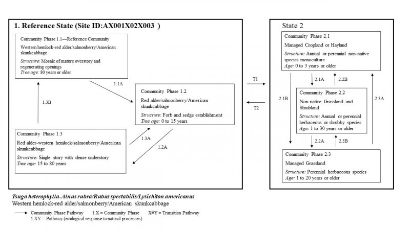
Click on box and path labels to scroll to the respective text.
