Natural Resources
Conservation Service
Ecological site R006XA308OR
Moist Scabland 14-18 PZ
Last updated: 9/11/2023
Accessed: 01/11/2025
General information
Provisional. A provisional ecological site description has undergone quality control and quality assurance review. It contains a working state and transition model and enough information to identify the ecological site.
MLRA notes
Major Land Resource Area (MLRA): 006X–Cascade Mountains, Eastern Slope
Stretching from northern Washington to southern Oregon, MLRA6 encompasses the mountain slopes, foothills, elevated plateaus and valleys on the eastern slopes of the Cascade mountains. This MLRA is a transitional area between the Cascade Mountains to the west and the lower lying Columbia Basalt Plateau to the east. Situated in the rain shadow of the Cascade Crest, this MLRA receives less precipitation than portions of the cascades further west and greater precipitation than the basalt plateaus to the east. Geologically, the majority of the MLRA is dominated by Miocene volcanic rocks, while the northern portion is dominated by Pre-Cretaceous metamorphic rocks and the southern portion is blanketed with a thick mantle of ash and pumice from Mount Mazama. The soils in the MLRA dominantly have a mesic, frigid, or cryic soil temperature regime, a xeric soil moisture regime, and mixed or glassy mineralogy. They generally are moderately deep to very deep, well drained, and loamy or ashy. Biologically, the MLRA is dominated by coniferous forest, large expanses of which are dominated by ponderosa pine, Douglas-fir or lodgepole pine. Areas experiencing cooler and moister conditions include grand fir, white fir, and western larch while the highest elevations include pacific silver fir, subalpine fir and whitebark pine. Economically, timber harvest and recreation are important land uses in these forests. Historically, many of these forests would have experienced relatively frequent, low and mixed severity fire favoring the development of mature forests dominated by ponderosa pine or Douglas-fir. In the southern pumice plateau forests, less frequent, higher severity fire was common and promoted the growth of large expanses of lodgepole pine forests.
LRU notes
This unit is characterized by ash mantled lava flows and glacial outwash plains on lower mountain slopes and foothills of the East Cascades in Oregon. Vegetation is largely dominated by forests of ponderosa pine with transitional dry mixed conifer forests where Douglas-fir and grand fir are sub dominant occurring in areas with greater effective precipitation. Historically, these forests have been influenced by a fire regime whereby frequent to moderately frequent, low and mixed severity fires would have favored the development of open stands of mature ponderosa pine. The climate of this unit is cool and dry with a predominately xeric soil moisture regime and frigid soil temperature regime. Geologically, underlying lithologies are dominated by Quaternary and late Tertiary basalt and basaltic andesite as well as mixed grain sediments deposited during Pleistocene glacial retreat. Unlike the nearby pumice plateau, this unit lacks the coarse pumice fragments that dominate the soil profile and cooler temperatures that favor lodgepole pine. This unit is south of the climate influences of the Columbia gorge and therefore does not support woodlands of Oregon white oak.
Ecological site concept
This site represents a shallow scabland site at the transition zone between the foothills of the Oregon east cascades and the Columbia plateau. This is a low productivity site with a reference plant community dominated by onespike oatgrass (Danthonia unispicata). This site often occurs within mound - intermound topography where it occupies the interspaces between raised mounds. Raised mounds and adjacent forest and woodland sites will often support plant communities with higher diversity and may include shrubs, trees and greater composition of deep-rooted perennial grasses.
This is a provisional ecological site and is subject to extensive review and revision before final approval. All data herein should be considered provisional and contingent upon field validation prior to use in conservation planning.
Development of this site as a range site was based on field data collection completed in 1996. It was revised and updated with information regarding ecological dynamics in 2020.
Associated sites
| R006XB208OR |
Shallow Slopes 14-20 PZ Adjacent south slopes, shrubs common |
|---|---|
| R006XA310OR |
Juniper-Oak Clayey Deeper soils, clayey textures, JUOC common |
Similar sites
| R006XB208OR |
Shallow Slopes 14-20 PZ Steeper south slopes, higher elevation range |
|---|---|
| R006XA310OR |
Juniper-Oak Clayey Deeper, clayey soils |
Table 1. Dominant plant species
| Tree |
Not specified |
|---|---|
| Shrub |
Not specified |
| Herbaceous |
(1) Danthonia unispicata |
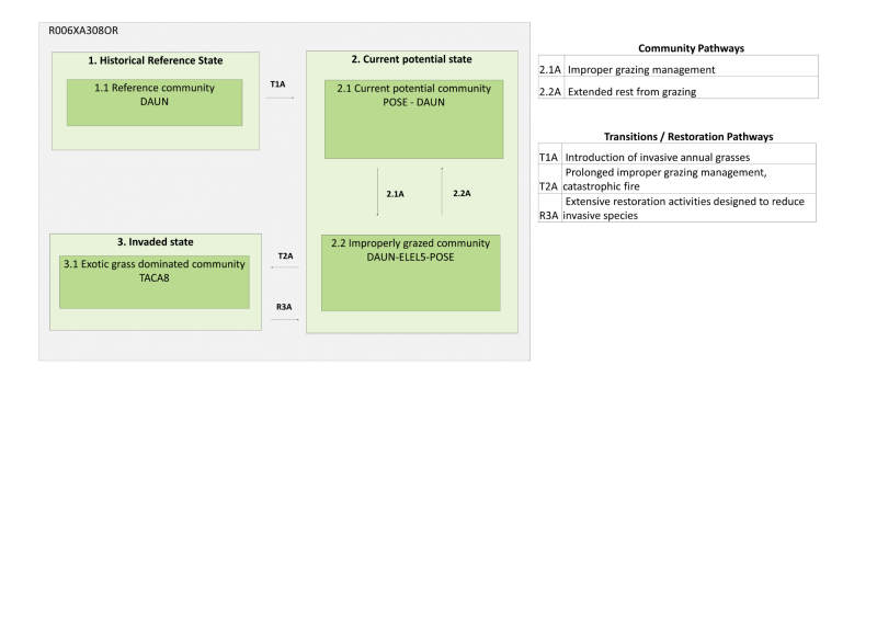
Click on box and path labels to scroll to the respective text.
| T1A | - | Introduction of invasive annual grasses |
|---|---|---|
| T1B | - | Prolonged improper grazing management, catastrophic fire |
| R3A | - | Extensive restoration activities designed to reduce invasive species |
State 1 submodel, plant communities
State 2 submodel, plant communities
| 2.1A | - | Improper grazing management and overutilization beyond acceptable limits of the site’s carrying capacity. |
|---|---|---|
| 2.2A | - | Extended rest from grazing allowing native grasses to increase in cover, possible reseeding of native grasses and additional treatments |
