Natural Resources
Conservation Service
Ecological site R007XY140WA
Sands
Last updated: 3/11/2025
Accessed: 04/10/2026
General information
Provisional. A provisional ecological site description has undergone quality control and quality assurance review. It contains a working state and transition model and enough information to identify the ecological site.
MLRA notes
Major Land Resource Area (MLRA): 007X–Columbia Basin
This MLRA is in the Walla Walla Plateau section of the Columbia Plateaus province of the Intermontane Plateaus. The Columbia River flows through this MLRA, and the Snake and Yakima Rivers join the Columbia River within it. This MLRA is almost entirely underlain by Miocene basalt flows. Columbia River Basalt is covered in most areas with as much as 200 feet of eolian, lacustrine, and alluvial deposits. The dominant soil orders in this MLRA are Aridisols and Entisols. The soils in the area dominantly have a mesic temperature regime, an aridic moisture regime, and mixed mineralogy. They generally are moderately deep to very deep and well drained to excessively drained.
Classification relationships
Major Land Resource Area (MLRA): 7 – Columbia Basin
LRU – Common Resource Areas (CRA):
7.1 – Sandy Missoula Flood Deposits
7.5 – Yakima Valley – Pleistocene Lake Basins
Ecological site concept
Diagnostics:
Sands is an upland shrub steppe site occurring on moderately deep to deep sand textured soils. The most common textures are sand, coarse sand and loamy fine sand.
Indian ricegrass, needle and thread, basin/Wyoming big sagebrush or bitterbrush are the dominate species in the Reference State. Snow buckwheat, rabbitbrush, Carey balsamroot, and fleabane are also common.
Principle Vegetative Drivers:
The coarse-textured, well drained soils drive the vegetative expression of this site. Sands ecological site favors shrubs and species adapted to sand.
Associated sites
| R007XY449WA |
Sandy |
|---|---|
| R007XY143WA |
Sandy Loam |
| R007XY120WA |
Stony |
| R007XY114WA |
Shallow Stony Sand |
Similar sites
| R007XY449WA |
Sandy Soils are loamy sands (loamy coarse sand, loamy sand, loamy fine sand, or loamy very fine sand) and have carbonates within the rooting zone. |
|---|
Table 1. Dominant plant species
| Tree |
Not specified |
|---|---|
| Shrub |
(1) Artemisia tridentata ssp. tridentata |
| Herbaceous |
(1) Achnatherum hymenoides |
Physiographic features
The landscape is part of the Columbia basalt plateau. Sands is commonly found on dunes, terraces & terrace escarpments, benches and hillslopes.
Physiographic Division: Intermontane Plateau
Physiographic Province: Columbia Plateau
Physiographic Sections: Walla Walla Plateau Section
Table 2. Representative physiographic features
| Landforms |
(1)
Basin
(2) Hills (3) Terrace (4) Escarpment (5) Dune |
|---|---|
| Flooding frequency | None |
| Ponding frequency | None |
| Elevation | 300 – 1,200 ft |
| Slope | 10 – 40% |
| Water table depth | 60 in |
| Aspect | W, NW, N, NE, E, SE, S, SW |
Table 3. Representative physiographic features (actual ranges)
| Flooding frequency | None |
|---|---|
| Ponding frequency | None |
| Elevation | 300 – 3,000 ft |
| Slope | 60% |
| Water table depth | Not specified |
Climatic features
The climate across MLRA 7 is characterized by moderately cold, wet winters, and hot, dry summers, with limited precipitation due to the rain shadow effect of the Cascades. The average annual precipitation for Sands is mostly between 4 and 10 inches. Seventy to seventy-five percent of the precipitation comes late October through March as a mixture of rain and snow. Precipitation that comes after March is not as effective for plant growth. June through early October can be dry. Freezing temperatures generally occur from late-October through early-April. Temperature extremes are -10 degrees in winter and 110 degrees in summer. Winter fog is variable and often quite localized, as the fog settles on some areas but not others.
Table 4. Representative climatic features
| Frost-free period (characteristic range) | 150-180 days |
|---|---|
| Freeze-free period (characteristic range) | |
| Precipitation total (characteristic range) | |
| Frost-free period (actual range) | 120-210 days |
| Freeze-free period (actual range) | |
| Precipitation total (actual range) | 102-254 in |
Influencing water features
A plant’s ability to grow on a site and overall plant production is determined by soil-water-plant relationships
1. Whether rain and melting snow runs off-site or infiltrates into the soil
2. Whether soil condition remain aerobic or become saturated and become anaerobic
3. Water drainage and how quickly the soil reaches wilting point
Sands ecological sites are excessively drained and dry down quicker than adjacent Loamy
ecological sites.
Soil features
This ecological site components are dominantly Xeric taxonomic subgroup of Torripsamments, Torriorthents and Haplocambids great groups of the Entisols and Aridisols taxonomic orders. Soils are dominantly very deep. Average available water capacity of about 3.0 inches (7.6 centimeters) in the 0 to 40 inches (0 to 100 centimeters) depth range.
Soil parent material is dominantly eolian or alluvium derived from mixed sources.
The associated soils are Burbank, Hezel, Quincy, Royal, Winchester and similar soils.
Dominate soil surface is loamy fine sand to sand.
Dominant particle-size class is sandy skeletal or sandy to sandy over loamy.
Table 5. Representative soil features
| Parent material |
(1)
Eolian deposits
(2) Alluvium |
|---|---|
| Surface texture |
(1) Sand (2) Coarse sand (3) Fine sand (4) Very fine sand |
| Drainage class | Well drained to excessively drained |
| Permeability class | Moderately rapid to rapid |
| Depth to restrictive layer | 60 in |
| Soil depth | 60 in |
| Surface fragment cover <=3" | 5% |
| Surface fragment cover >3" | 2% |
| Available water capacity (0-40in) |
3 in |
| Calcium carbonate equivalent (0-80in) |
15% |
| Electrical conductivity (0-80in) |
2 mmhos/cm |
| Sodium adsorption ratio (0-80in) |
Not specified |
| Soil reaction (1:1 water) (0-10in) |
6.1 – 9 |
| Subsurface fragment volume <=3" (0-80in) |
15% |
| Subsurface fragment volume >3" (0-80in) |
5% |
Table 6. Representative soil features (actual values)
| Drainage class | Not specified |
|---|---|
| Permeability class | Not specified |
| Depth to restrictive layer | Not specified |
| Soil depth | Not specified |
| Surface fragment cover <=3" | 25% |
| Surface fragment cover >3" | 15% |
| Available water capacity (0-40in) |
0.9 – 7.5 in |
| Calcium carbonate equivalent (0-80in) |
Not specified |
| Electrical conductivity (0-80in) |
Not specified |
| Sodium adsorption ratio (0-80in) |
Not specified |
| Soil reaction (1:1 water) (0-10in) |
Not specified |
| Subsurface fragment volume <=3" (0-80in) |
35% |
| Subsurface fragment volume >3" (0-80in) |
25% |
Ecological dynamics
Vegetation Dynamics:
Sands produces about 500 to 800 pounds per acre of biomass annually.
Big sagebrush (Wyoming, basin) or bitterbrush with needle and thread and Indian ricegrass are dominant in the Reference State and warrants a degree of understanding.
Wyoming sagebrush in a long-lived, multi-branched, evergreen shrub. Size varies from three to five feet depending on soil and site conditions. Wyoming big sagebrush has a significant rooting system, composed of a two-part rooting structure with a primary deep taproot, and a shallow extensive network of finer roots that spread laterally. This rooting system allows Wyoming big sagebrush to survive in the hottest and driest portions of the sagebrush range by tapping into groundwater sources deep into the soil profile itself. This also allows Wyoming big sagebrush to be more competitive with bunchgrasses when the landscape positions or soils are less ideal for grass species to maintain the competitive advantage.
Antelope bitterbrush is a very palatable, high quality shrub for big game and livestock. It is adapted to a wide range of soils and precipitation. Bitterbrush is usually 2-6 feet in height and up to 8 feet in width. Rodents normally cache bitterbrush seed within 50-75 feet of an existing seed source. Following a fire, the rodent seed caches become an important source of regeneration. Another important source of regeneration are pockets of unburned rangeland that provide much needed seed to the system.
Needle and thread is a very drought tolerant perennial bunchgrass. It prefers excessively drained sandy and coarse textured gravelly loam soils. Needle and thread produces erect, unbranched stems about three feet in height. The seeds have a 4 to 5-inch long twisted awn. With wetting and drying the seed drills itself into the ground. Thus, needle and thread is one of the best seeders in the reference community. With grazing pressure, needle and thread initially increases.
Indian ricegrass is a winter hardy, cool-season bunchgrass. It has tightly rolled, slender leaves. Indian ricegrass is known for its ability to reseed and stabilize shifting sand.
The stability and resiliency of the reference communities is directly linked to the health and vigor of needle and thread and Indian ricegrass Research has found that the community remains resistant to medusahead if the site maintains at least 0.8 mid-sized bunchgrass plant/sq. ft. (K. Davies, 2008). These two grasses help hold the system together. If we lose either grass the ecosystem begins to unravel.
The natural disturbance regime for grassland communities is periodic lightning-caused fires. The fire return intervals (FRI) listed in research for sagebrush steppe communities is quite variable. Ponderosa pine communities have the shortest FRI of about 10-20 years (Miller). The FRI increases as one moves to wetter forested sites or to dries shrub steppe
communities. Given the uncertainties and opinions or reviewers, a mean of 75 years was chosen for Wyoming sagebrush communities (Rapid Assessment Model). This would place the historic FRI for grassland steppe around 30-50 years.
The effect of fire on the community depends upon the severity of the burn. With a light to moderate fire there can be a mosaic of burned and unburned patches. Bunchgrasses thrive as the fire does not get into the crown. With adequate soil moisture the bunchgrasses can make tremendous growth the year after the fire. Largely, the community is not affected by lower intensity fire. Needle and thread and Indian ricegrass are native species that can increase via new seedlings following a fire.
A severe fire puts stress on the entire community. Spots and areas that were completely sterilized are especially vulnerable to exotic invasive species. Sterilized spots must be seeded to prevent invasive species (annual grasses, tumble mustard) from totally occupying the site. Needle and thread and Indian ricegrass may have weak vigor for a few years but generally survive.
Grazing is another common disturbance that occurs in this ecological site. Grazing pressure can be defined as heavy grazing intensity, or frequent grazing during reproductive growth, or season-long grazing (the same plants grazed more than once). As grazing pressure increases the plant community unravels in stages:
1. Indian ricegrass declines while needle and thread increase
2. Needle and thread also declines. Invasive species such as cheatgrass and knapweed colonize the site
3. With further decline the site can become a cheatgrass dominated community
Managing grasslands to improve the vigor and health of needle and thread and Indian ricegrass begins with an understanding their needs. New growth each year begins from basal buds. Both grasses reproduce via seed and need to produce viable seed on a regular basis.
Repeated critical period grazing (boot stage through seed formation) is especially damaging. Over several years each native bunchgrass pasture should be rested during the critical period two out of every three years (approximately April – June 30). And each pasture should be rested the entire growing-season every third year (approximately
March – June 30).
In the spring each year it is important to monitor and maintain an adequate topgrowth: (1) so plants have enough energy to replace basal buds annually, (2) to optimize regrowth following spring grazing, and (3) to protect the elevated growing points of bluebunch wheatgrass.
Needle and thread and Indian ricegrass remains competitive if:
(1) Basal buds are replaced annually,
(2) Enough top-growth is maintained for growth, protection of growing points, seed production and,
(3) The timing of grazing and non-grazing is managed over a several-year period. Careful management of late spring grazing is especially critical
For more grazing management information refer to Range Technical Notes found in Section I Reference Lists of NRCS Field Office Technical Guide for Washington State.
In Washington, needle and thread-Indian ricegrass communities provide habitat for a variety of upland wildlife species.
State and transition model
More interactive model formats are also available.
View Interactive Models
More interactive model formats are also available.
View Interactive Models
Click on state and transition labels to scroll to the respective text
Ecosystem states
State 1 submodel, plant communities
State 2 submodel, plant communities
State 3 submodel, plant communities
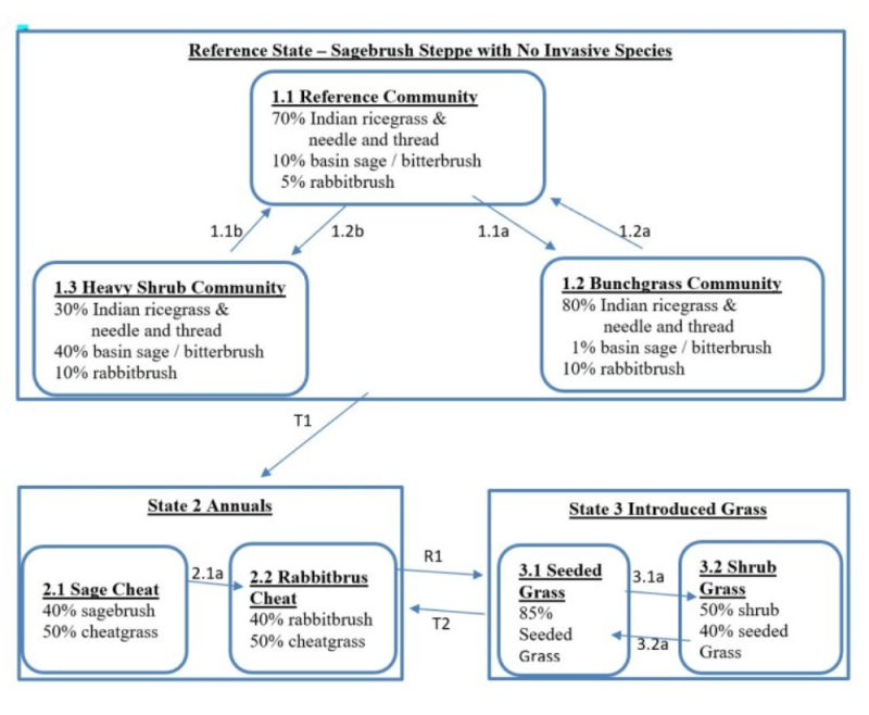
State 1
Reference
State 1 represents shrub steppe with no invasive or exotic weed species. All the functional, structural groups are represented by one or more native species. The Reference Community 1.1 is native grass - shrub dominated by needle and thread, Indian ricegrass, sagebrush, or bitterbrush. Native forbs are also present. Fire eliminates the shrubs, so Community 1.2 is a grassland community. Community 1.3 is heavy shrub-grass. Reference State Community Phases: 1.1 Reference Sagebrush/bitterbrush – needle and thread – Indian ricegrass At-risk Communities: • Community 1.3 is most at risk of transitioning to State 3 • All communities are at risk when native bunchgrass density falls to 10 percent and cheatgrass has colonized the site.
Community 1.1
Native Grass and Shrub
The reference community 1.1 is native grass - shrub dominated by needle and thread, Indian ricegrass sagebrush and/or bitterbrush. Native forbs are also present.
Dominant plant species
-
basin big sagebrush (Artemisia tridentata ssp. tridentata), shrub
-
antelope bitterbrush (Purshia tridentata), shrub
-
rubber rabbitbrush (Ericameria nauseosa), shrub
-
yellow rabbitbrush (Chrysothamnus viscidiflorus), shrub
-
Indian ricegrass (Achnatherum hymenoides), grass
-
needle and thread (Hesperostipa comata), grass
Figure 1. Annual production by plant type (representative values) or group (midpoint values)
Community 1.2
Bunchgrass
Community 1.2 is a grassland community.
Dominant plant species
-
Indian ricegrass (Achnatherum hymenoides), grass
-
needle and thread (Hesperostipa comata), grass
Community 1.3
Heavy Shrub
Community 1.3 is heavy shrub-grass community.
Dominant plant species
-
basin big sagebrush (Artemisia tridentata ssp. tridentata), shrub
-
antelope bitterbrush (Purshia tridentata), shrub
-
Indian ricegrass (Achnatherum hymenoides), grass
-
needle and thread (Hesperostipa comata), grass
Pathway 1.1B
Community 1.1 to 1.2
Result: shift from reference community to heavy shrub community. This shift is from bunchgrass dominance to shrub dominance. Primary Trigger: heavy grazing pressure (heavy grazing intensity, season long grazing and frequent late spring grazing) Ecological Process: consistent defoliation pressure to Indian ricegrass and needle and thread results in poor vigor, shrinking crowns and quite a bit of plant mortality. Sagebrush and needle and thread expand cover via new seedlings into the niche space available from the declining bluebunch wheatgrass plants.
Pathway 1.1A
Community 1.1 to 1.3
Result: shift from reference community to bunchgrass community Primary Trigger: moderate severity fire Ecological Process: fire kills fire sensitive shrubs (sagebrush and bitterbrush) and this releases resources for bunchgrasses and rabbitbrush. The fire does not burn into bunchgrass crowns, so they thrive and expand post-fire via tillering and new seedlings. Burned rabbitbrush plants sprout and new seedlings are established.
Pathway 1.2A
Community 1.2 to 1.1
Result: shift from bunchgrass community to reference community. Primary Trigger: soil disturbance and the natural regeneration process of sagebrush. Ecological Process: sagebrush seed spreads from sagebrush plants that survived the fire. At spots of soil disturbance, the sagebrush seeds have soil-soil contact, which increases germination and some seedlings become established in the process. Shading causes a slight decrease in bunchgrasses.
Pathway 1.3A
Community 1.3 to 1.1
Result: shift from heavy shrub community to reference community. The community shifts from shrub dominance to bunchgrass dominance. Primary Trigger: moderate severity fire Ecological Process: fire is spotty and kills most but not all the fire sensitive shrubs (sagebrush and rabbitbrush). The fire does not burn into bunchgrass crowns, so they thrive and expand post-fire via tillering and new seedlings. Burned rabbitbrush plants sprout and new seedlings are established.
State 2
Annual
State 2 represents sites dominated by invasive annual species and have crossed a biological threshold. As Reference State begins to unravel the dominant bunchgrasses decline while invasive grasses become more and more prominent. Virtually all the native functional, structural groups are missing in State 2. Community Phases for State 2: 2.1 Sagebrush – Annual Grass 2.2 Rabbitbrush – Annual Grass Dominate State 2 Species: Annual grasses such as cheatgrass, sagebrush and rabbitbrush. Other species can include mustard, prickly lettuce, Russian thistle and diffuse knapweed.
Community 2.1
Sagebrush and Cheatgrass
Community 2.2
Rabbitbrush and Cheatgrass
Pathway 2.1A
Community 2.1 to 2.2
Result: shift from sagebrush-cheatgrass community to rabbitbrush-cheatgrass community. Primary Trigger: moderate severity fire Ecological Process: fire sensitive shrubs (sagebrush and bitterbrush) are killed by the fire. Rabbitbrush expands via sprouting and new seedlings while cheatgrass expands by seedlings.
State 3
Seeded
State 3 represents a site that has been seeded to grasses such as Siberian wheatgrass, crested wheatgrass and Secar Snake River wheatgrass. State 3 is stable if 0.8 plant per square foot or greater of the desired bunchgrasses is maintained. Dominate Species for State 3: Desirable seeded grass species with or without legumes
Community 3.1
Seeded Grass
Community 3.2
Shrubs and Seeded Grass
Pathway 3.1A
Community 3.1 to 3.2
Result: shift from seeded grass community to shrub-seeded grass community. Primary Trigger: grazing pressure to desirable seeded grasses Ecological Process: consistent defoliation pressure to seeded grasses results in poor vigor, shrinking crowns and plant mortality. Shrubs increase to occupy the niche space vacated by the seeded grasses.
Transition T1A
State 1 to 2
T1 Result: shift from Reference State to State 2 which is dominated by annuals and shrubs. This transition occurs once the cover of needle and thread and Indian ricegrass declines to less than 10 percent and invasive species cover is greater than 40 percent. Primary Trigger: soil disturbances (rodents, badgers) create openings or opportunities in the community or a high moisture year causes a micro-burst of cheatgrass and is the principle means of colonization. Secondary Trigger: Repeated fire does the same thing. In Washington, chronic season-long grazing caused more acres of State 2 than repeated fire. Repeated fire is a much more common event in south Central Washington. Ecological process. 1. Colonization: annually cheatgrass seed blows onto most Reference State sites. This seed is waiting for opportunity to germinate and compete with the native species for space, light and moisture. When the right year happens even pristine communities in the Reference State are susceptible to colonization by cheatgrass. 2. Dominance by annuals: the unraveling of the native plant community begins with weakened vigor and less cover of the dominant bunchgrasses, or the sudden loss of a major species such as Indian ricegrass. The invasive annual grasses in make a dramatic increase to dominate the community. Consistent defoliation pressure causes low vigor and reduced cover of Indian ricegrass and needle and thread. Initially needle and thread and the annual grasses increase while Indian ricegrass declines. As the defoliation pressure continues, needle and thread also decreases allowing the annual grasses to become dominate. Grazing pressure is defined as heavy grazing, season long grazing or frequent late spring grazing. Indicators: The occurrence of annual grasses on sites where they had been absent. Decreasing vigor and cover of needle and thread and Indian ricegrass and increasing cover of invasive annual species. Increasing distance between perennial species. Decreasing soil organic matter, soil water retention, limited water infiltration and percolation in the soil profile.
Restoration pathway R2A
State 2 to 3
Recovery R1 Result: shift from State 2 dominated by annual grasses to State 3 seeded grasses. This restoration transition does not occur without significant time and inputs to control weeds, prepare a seedbed, seed desirable species, and post-seeding weed control and management. This requires a commitment of two years or more for weed control. Care must be taken to maintain soil structure so that the seedbed has many safe-sites for the seed. Seed placement must be managed to achieve seed-soil contact at very shallow depth (about 1/8 inch is desired). Proper grazing management is essential to maintain the stand post-seeding. Siberian wheatgrass, crested wheatgrass, Secar Snake River wheatgrass, thickspike wheatgrass and Sherman big bluegrass may be seeded. The actual transition occurs when the seeded species have successfully established and are outcompeting the annual species for cover and dominance of resources.
Restoration pathway R3A
State 3 to 2
T2 Result: Transition from State 3 seeded grass to State 2 annual grasses. This transition occurs when the desirable seeded grasses become minor to the dominant annual grasses. Ecological process: consistent defoliation pressure to the seeded grasses results in poor vigor, shrinking crowns and plant mortality. At the seeded grass community unravels, invasive annual grasses colonize the site and become more and more common with the loss of each bunchgrass. Primary trigger: grazing pressure on the seeded grasses reduce the vigor and density of key bunchgrass species. Indicators: shrinking crowns and mortality of desirable species, increasing caps gaps between perennial species, increasing cover by annual grasses
Additional community tables
Table 7. Community 1.1 plant community composition
| Group | Common name | Symbol | Scientific name | Annual production (lb/acre) | Foliar cover (%) | |
|---|---|---|---|---|---|---|
|
Shrub/Vine
|
||||||
| 1 | Non-sprouting Shrubs - Subdominant | 80 | ||||
| basin big sagebrush | ARTRT | Artemisia tridentata ssp. tridentata | – | – | ||
| antelope bitterbrush | PUTR2 | Purshia tridentata | – | – | ||
| 2 | Sprouting Shrubs - Minor | 40 | ||||
| rubber rabbitbrush | ERNA10 | Ericameria nauseosa | – | – | ||
| yellow rabbitbrush | CHVI8 | Chrysothamnus viscidiflorus | – | – | ||
| spineless horsebrush | TECA2 | Tetradymia canescens | – | – | ||
|
Grass/Grasslike
|
||||||
| 3 | Dominant Mid-Size Bunchgrasses | 600 | ||||
| Indian ricegrass | ACHY | Achnatherum hymenoides | – | – | ||
| needle and thread | HECO26 | Hesperostipa comata | – | – | ||
| 4 | Other Mid-Size Bunchgrasses - Minor | 40 | ||||
| thickspike wheatgrass | ELLA3 | Elymus lanceolatus | – | – | ||
| sand dropseed | SPCR | Sporobolus cryptandrus | – | – | ||
| bluebunch wheatgrass | PSSP6 | Pseudoroegneria spicata | – | – | ||
| squirreltail | ELEL5 | Elymus elymoides | – | – | ||
| Thurber's needlegrass | ACTH7 | Achnatherum thurberianum | – | – | ||
| 5 | Short Grasses - Minor | 40 | ||||
| Sandberg bluegrass | POSE | Poa secunda | – | – | ||
| sixweeks fescue | VUOC | Vulpia octoflora | – | – | ||
|
Forb
|
||||||
| 6 | Native Forbs - Minor | 40 | ||||
| Munro's globemallow | SPMU2 | Sphaeralcea munroana | – | – | ||
| Carey's balsamroot | BACA3 | Balsamorhiza careyana | – | – | ||
| evening primrose | OENOT | Oenothera | – | – | ||
| hawksbeard | CREPI | Crepis | – | – | ||
| fleabane | ERIGE2 | Erigeron | – | – | ||
| buckwheat | ERIOG | Eriogonum | – | – | ||
| Indian paintbrush | CASTI2 | Castilleja | – | – | ||
| low pussytoes | ANDI2 | Antennaria dimorpha | – | – | ||
| Douglas' dustymaiden | CHDO | Chaenactis douglasii | – | – | ||
| trumpet | COLLO | Collomia | – | – | ||
| woolly plantain | PLPA2 | Plantago patagonica | – | – | ||
| common yarrow | ACMI2 | Achillea millefolium | – | – | ||
| snow buckwheat | ERNI2 | Eriogonum niveum | – | – | ||
| lupine | LUPIN | Lupinus | – | – | ||
| longleaf phlox | PHLO2 | Phlox longifolia | – | – | ||
| desertparsley | LOMAT | Lomatium | – | – | ||
| milkvetch | ASTRA | Astragalus | – | – | ||
| owl's-clover | ORTHO | Orthocarpus | – | – | ||
| spiny phlox | PHHO | Phlox hoodii | – | – | ||
| granite prickly phlox | LIPU11 | Linanthus pungens | – | – | ||
| larkspur | DELPH | Delphinium | – | – | ||
| western stoneseed | LIRU4 | Lithospermum ruderale | – | – | ||
Interpretations
Supporting information
Inventory data references
Data to populate Reference Community came from several sources: (1) NRCS ecological sites from 2004, (2) Soil Conservation Service range sites from 1980s and 1990s, (3) Daubenmire’s habitat types, and (4) ecological systems from Natural Heritage Program
Other references
Boling M., Frazier B., Busacca, A., General Soil Map of Washington, Washington State University, 1998
Daubenmire, R., Steppe Vegetation of Washington, EB1446, March 1968
Davies, Kirk, Medusahead Dispersal and Establishment in Sagebrush Steppe Plant Communities, Rangeland Ecology & Management, 2008
Environmental Protection Agency, map of Level III and IV Ecoregions of Washington, June 2010
Miller, Baisan, Rose and Pacioretty, “Pre and Post Settlement Fire regimes in mountain Sagebrush communities: The Northern Intermountain Region
Natural Resources Conservation Service, map of Common Resource Areas of Washington, 2003
Rapid Assessment Reference Condition Model for Wyoming sagebrush LANDFIRE project, 2008
Rocchio, Joseph & Crawford, Rex C., Ecological Systems of Washington State. A Guide to Identification. Washington State Department of Natural Resources, October 2015. Pages 156-161 Inter-Mountain Basin Big Sagebrush.
Rouse, Gerald, MLRA 8 Ecological Sites as referenced from Natural Resources Conservation Service-Washington FOTG, 2004
Soil Conservation Service, Range Sites for MLRA 8 from 1980s and 1990s
Tart, D., Kelley, P., and Schlafly, P., Rangeland Vegetation of the Yakima Indian reservation, August 1987, YIN Soil and Vegetation Survey
Approval
Kirt Walstad, 3/11/2025
Rangeland health reference sheet
Interpreting Indicators of Rangeland Health is a qualitative assessment protocol used to determine ecosystem condition based on benchmark characteristics described in the Reference Sheet. A suite of 17 (or more) indicators are typically considered in an assessment. The ecological site(s) representative of an assessment location must be known prior to applying the protocol and must be verified based on soils and climate. Current plant community cannot be used to identify the ecological site.
| Author(s)/participant(s) | |
|---|---|
| Contact for lead author | |
| Date | 08/14/2023 |
| Approved by | Kirt Walstad |
| Approval date | |
| Composition (Indicators 10 and 12) based on | Annual Production |
Indicators
-
Number and extent of rills:
-
Presence of water flow patterns:
-
Number and height of erosional pedestals or terracettes:
-
Bare ground from Ecological Site Description or other studies (rock, litter, lichen, moss, plant canopy are not bare ground):
-
Number of gullies and erosion associated with gullies:
-
Extent of wind scoured, blowouts and/or depositional areas:
-
Amount of litter movement (describe size and distance expected to travel):
-
Soil surface (top few mm) resistance to erosion (stability values are averages - most sites will show a range of values):
-
Soil surface structure and SOM content (include type of structure and A-horizon color and thickness):
-
Effect of community phase composition (relative proportion of different functional groups) and spatial distribution on infiltration and runoff:
-
Presence and thickness of compaction layer (usually none; describe soil profile features which may be mistaken for compaction on this site):
-
Functional/Structural Groups (list in order of descending dominance by above-ground annual-production or live foliar cover using symbols: >>, >, = to indicate much greater than, greater than, and equal to):
Dominant:
Sub-dominant:
Other:
Additional:
-
Amount of plant mortality and decadence (include which functional groups are expected to show mortality or decadence):
-
Average percent litter cover (%) and depth ( in):
-
Expected annual annual-production (this is TOTAL above-ground annual-production, not just forage annual-production):
-
Potential invasive (including noxious) species (native and non-native). List species which BOTH characterize degraded states and have the potential to become a dominant or co-dominant species on the ecological site if their future establishment and growth is not actively controlled by management interventions. Species that become dominant for only one to several years (e.g., short-term response to drought or wildfire) are not invasive plants. Note that unlike other indicators, we are describing what is NOT expected in the reference state for the ecological site:
-
Perennial plant reproductive capability:
Print Options
Sections
Font
Other
The Ecosystem Dynamics Interpretive Tool is an information system framework developed by the USDA-ARS Jornada Experimental Range, USDA Natural Resources Conservation Service, and New Mexico State University.
Click on box and path labels to scroll to the respective text.