
Natural Resources
Conservation Service
Ecological site R007XY449WA
Sandy
Last updated: 4/01/2025
Accessed: 04/12/2025
General information
Provisional. A provisional ecological site description has undergone quality control and quality assurance review. It contains a working state and transition model and enough information to identify the ecological site.
MLRA notes
Major Land Resource Area (MLRA): 007X–Columbia Basin
This MLRA is in the Walla Walla Plateau section of the Columbia Plateaus province of the Intermontane Plateaus. The Columbia River flows through this MLRA, and the Snake and Yakima Rivers join the Columbia River within it. This MLRA is almost entirely underlain by Miocene basalt flows. Columbia River Basalt is covered in most areas with as much as 200 feet of eolian, lacustrine, and alluvial deposits. The dominant soil orders in this MLRA are Aridisols and Entisols. The soils in the area dominantly have a mesic temperature regime, an aridic moisture regime, and mixed mineralogy. They generally are moderately deep to very deep and well drained to excessively drained.
Classification relationships
Major Land Resource Area (MLRA): 007X – Columbia Basin
LRU – Common Resource Areas (CRA):
7.1 – Sandy Missoula Flood Deposits
7.5 – Yakima Valley – Pleistocene Lake Basins
Ecological site concept
Diagnostics:
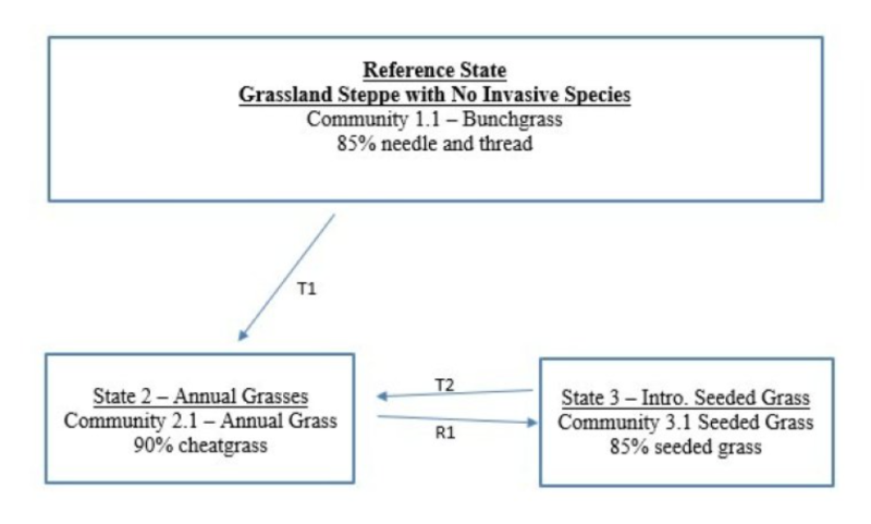
Sandy is an upland ecological site occurring on sandy loam textured soils that are moderately deep to deep. The soils on the Sandy ecological site have carbonates at or near the surface, so available water for plants is limited.
Whereas, the surrounding sites are shrub steppe, the Sandy ecological site stands out because it is a grassland site. The Sandy ecological site is almost a monoculture of needle and thread in the Reference State and a monoculture of cheatgrass in the altered state. Shrubs are virtually, nonexistent and forbs are a minor component.
The Sandy and Sandy Loamy ecological sites both have a sandy loam soil texture. The difference is that the Sandy ecological site has carbonates up to the surface, while on Sandy Loam ecological site, the carbonates are not encountered until a depth of 18 inches or greater. Sandy Loam ecological site supports a shrub steppe community of Wyoming big sagebrush, bluebunch wheatgrass and needle and thread. Sandy ecological site, on the other hand, has a grassland community dominated by needle and thread.
The line between Sandy and Sandy loam ecological sites is often sharp. It is possible to stand with one foot on Sandy ecological site and the other on Sandy Loam ecological site.
Principle Vegetative Drivers:
The carbonates at or near the surface limits available water for plants, and thus, drives the grassland vegetative expression of the Sandy ecological site.
Associated sites
R007XY143WA |
Sandy Loam |
---|---|
R007XY140WA |
Sands |
R007XY114WA |
Shallow Stony Sand |
Table 1. Dominant plant species
Tree |
Not specified |
---|---|
Shrub |
Not specified |
Herbaceous |
(1) Hesperostipa comata |
Physiographic features
The landscape is part of the Columbia basalt plateau. The Sandy ecological site is commonly found on terraces and fan terraces, mesas, hillslopes, outwash plains, benches and plateaus.
Physiographic Division: Intermontane Plateau
Physiographic Province: Columbia Plateau
Physiographic Sections: Walla Walla Plateau Section
Table 2. Representative physiographic features
Landforms |
(1)
Basin
(2) Valley (3) Terrace (4) Alluvial flat |
---|---|
Flooding frequency | None |
Ponding frequency | None |
Elevation | 300 – 1,200 ft |
Slope | 10 – 55% |
Water table depth | 60 in |
Aspect | W, NW, N, NE, E, SE, S, SW |
Table 3. Representative physiographic features (actual ranges)
Flooding frequency | Not specified |
---|---|
Ponding frequency | Not specified |
Elevation | 300 – 1,800 ft |
Slope | 60% |
Water table depth | Not specified |
Climatic features
The climate across MLRA 007X is characterized by moderately cold, wet winters, and hot, dry summers, with limited precipitation due to the rain shadow effect of the Cascades. Seventy to seventy-five percent of the precipitation comes late-October through March as a mixture of rain and snow. Precipitation that comes after March is not as effective for plant growth. June through early-October can be dry. Freezing temperatures generally occur from late-October through early-April. Temperature extremes are -10 degrees Fahrenheit in winter and 110 degrees Fahrenheit in summer. Winter fog is variable and often quite localized, as the fog settles on some areas but not others.
Table 4. Representative climatic features
Frost-free period (characteristic range) | 150-180 days |
---|---|
Freeze-free period (characteristic range) | |
Precipitation total (characteristic range) | 102-254 in |
Frost-free period (actual range) | 140-200 days |
Freeze-free period (actual range) | |
Precipitation total (actual range) |
Influencing water features
A plant’s ability to grow on a site and overall plant production is determined by soil-water-plant relationships
1. Whether rain and melting snow runs off-site or infiltrates into the soil
2. Whether soil condition remain aerobic or become saturated and become anaerobic
3. Water drainage and how quickly the soil reaches wilting point
Sandy ecological sites have less available water than Sandy loam ecological sites because the carbonates are at or near the soil surface. Soils are well drained and dry down quicker than adjacent Loamy ecological sites.
Soil features
This ecological site’s soil components are dominantly Xeric taxonomic subgroup of Torriorthents and Haplocambids great groups of the Entisols and Aridisols taxonomic orders. Soils are dominantly very deep. Average available water capacity of about 3.5 inches (8.9 cm) in the 0 to 40 inches (0-100 cm) depth range.
The associated soils are Finley, Neppel and similar soils.
Table 5. Representative soil features
Parent material |
(1)
Alluvium
|
---|---|
Surface texture |
(1) Fine sandy loam (2) Cobbly fine sandy loam |
Family particle size |
(1) Coarse-silty (2) Coarse-loamy |
Drainage class | Well drained |
Depth to restrictive layer | 60 in |
Soil depth | 60 in |
Surface fragment cover <=3" | 10% |
Surface fragment cover >3" | 2% |
Available water capacity (0-40in) |
3.5 in |
Calcium carbonate equivalent (Depth not specified) |
10 – 30% |
Electrical conductivity (Depth not specified) |
2 mmhos/cm |
Sodium adsorption ratio (Depth not specified) |
Not specified |
Soil reaction (1:1 water) (0-10in) |
7.4 – 9.6 |
Subsurface fragment volume <=3" (Depth not specified) |
25% |
Subsurface fragment volume >3" (Depth not specified) |
10% |
Table 6. Representative soil features (actual values)
Drainage class | Not specified |
---|---|
Depth to restrictive layer | Not specified |
Soil depth | Not specified |
Surface fragment cover <=3" | 25% |
Surface fragment cover >3" | 25% |
Available water capacity (0-40in) |
2.1 – 5.1 in |
Calcium carbonate equivalent (Depth not specified) |
Not specified |
Electrical conductivity (Depth not specified) |
Not specified |
Sodium adsorption ratio (Depth not specified) |
Not specified |
Soil reaction (1:1 water) (0-10in) |
Not specified |
Subsurface fragment volume <=3" (Depth not specified) |
35% |
Subsurface fragment volume >3" (Depth not specified) |
30% |
Ecological dynamics
Vegetation Dynamics:
Sandy ecological site produces about 400 to 700 pounds per acre of biomass annually.
The Sandy ecological site is a grassland site with needle and thread as the dominant plant. Needle and thread is a very drought tolerant perennial bunchgrass. It prefers excessively drained sandy and coarse textured gravelly loam soils. Needle and thread produces erect, unbranched stems about three feet in height. The seeds have a four to five-inch long twisted awn, and with wetting and drying the seed drills itself into the ground. Thus, needle and thread is one of the best natural seeders of all the native species.
The stability and resiliency of the reference communities is directly linked to the health and vigor of needle and thread. Research has found that the community remains resistant to medusahead if the site maintains at least 0.8 plants per square foot of mid-sized bunchgrass (K. Davies, 2008). These two grasses help hold the system together. As needle and thread plants decline, the ecosystem begins to unravel.
The natural disturbance regime for grassland communities is periodic lightning-caused fires. The fire return intervals (FRI) listed in research for sagebrush steppe communities is quite variable. Ponderosa pine communities have the shortest FRI of about 10 to 20 years (Miller). The FRI increases as one moves to wetter forested sites or to dries shrub steppe
communities. Given the uncertainties and opinions or reviewers, a mean of 75 years was chosen for Wyoming big sagebrush communities (Rapid Assessment Model). This would place the historic FRI for grassland steppe around 30 to 50 years.
Fire is not a major concern on this ecological site. There are no shrubs to lose to fire and burn severity is generally low to moderate because the Sandy ecological site is grassland. And needle and thread is pretty much fire tolerant as fire rarely burns into the crown of the plant.
Grazing is another common disturbance that occurs in this ecological site. Grazing pressure can be defined as heavy grazing intensity, or frequent grazing during reproductive growth, or season-long grazing (the same plants grazed more than once). As grazing pressure increases the needle and thread is replaced by cheatgrass.
Managing grasslands to improve the vigor and health of needle and thread begins with an understanding of the needs. New growth each year begins from basal buds. Needle and thread also reproduces via seed and needs to produce viable seed on a regular basis.
Repeated critical period grazing (boot stage through seed formation) is especially damaging. Over several years each native bunchgrass pasture should be rested during the critical period two out of every three years (approximately April 1 through June 30). And each pasture should be rested the entire growing-season every third year (approximately
March 1 – June 30).
In the spring each year it is important to monitor and maintain an adequate top growth: (1) so plants have enough energy to replace basal buds annually, (2) to optimize regrowth following spring grazing and (3) so needle and thread can produce viable seed.
Needle and thread remains competitive if:
(1) Basal buds are replaced annually,
(2) Enough top-growth is maintained for growth and seed production, and
(3) The timing of grazing and non-grazing is managed over a several-year period. Careful management of late spring grazing is especially critical
For more grazing management information refer to Range Technical Notes found in Section I Reference Lists of NRCS Field Office Technical Guide for Washington State.
In Washington, needle and thread-Indian ricegrass communities provide habitat for a variety of upland wildlife species.
State and transition model

More interactive model formats are also available.
View Interactive Models
More interactive model formats are also available.
View Interactive Models
Click on state and transition labels to scroll to the respective text
Ecosystem states
State 1 submodel, plant communities
State 2 submodel, plant communities
State 3 submodel, plant communities
State 1
Reference
State 1 represents grassland steppe with no invasive or exotic weed species. All the functional, structural groups are represented by one or more native species. The Reference Community 1.1 is dominated by needle and thread. Sandy mostly has no shrubs and forbs are a minor component. All communities in the Reference State are at risk on invasion by cheatgrass. Cheatgrass seeds blow onto most sites annually awaiting an opportunity to colonize the site.
Community 1.1
Needle and Thread Bunchgrass
Figure 1. Annual production by plant type (representative values) or group (midpoint values)
State 2
Annual Invaded
State 2 represents sites dominated by invasive annual species and has crossed a biological threshold. As state 1 begins to unravel needle and thread declines while invasive grasses become more and more prominent. Virtually all the native functional, structural groups are missing in state 2. Dominant state 2 species: Annual grasses such as cheatgrass. Other common species can include Russian thistle, mustard, prickly lettuce and diffuse knapweed.
Community 2.1
Cheatgrass and Broadleaf Weeds
90% cheatgrass Other common species can include Russian thistle, mustard, prickly lettuce and diffuse knapweed.
State 3
Seeded
State 3 represents a site that has been seeded to desirable grasses such as Siberian wheatgrass, crested wheatgrass and needle and thread. state 3 is stable if 0.8 plant per square foot or greater of the desired bunchgrasses is maintained. Dominant species for state 3: Desirable seeded grass species community phases for state 3: 3.1 Seeded Grass
Community 3.1
Seeded Grasses
Transition T1A
State 1 to 2
Result: shift from Reference State (all native species) to State 2 which is dominated by annual grasses. This transition occurs once the cover of needle and thread declines to less than 10 percent and invasive species cover is greater than 40 percent. Primary Trigger: grazing pressure (heavy grazing, season long grazing or frequent late spring grazing) to needle and thread. In Washington, chronic season-long grazing caused more acres of State 2 than anything else. Repeated fire, another trigger, is a much more common event in south Central Washington than elsewhere. Ecological process: 1. Colonization of invasive species: Cheatgrass seed blows onto most site annually. As opportunity presents itself, cheatgrass colonizes a site. Secondary trigger of colonization is soil disturbances (rodents, badgers), or a high moisture year causes a micro-burst of cheatgrass and is the principle means of colonization. 2. Expansion of invasive species: consistent defoliation pressure to needle and thread causes low vigor, low production of viable seed, fewer seedlings and reduced cover of needle and thread. As the grazing pressure continues, annual grasses become dominate. Indicators: The occurrence of annual grasses on sites where there has been none. Decreasing vigor and cover of needle and thread and increasing cover of invasive annual species. Increasing distance between perennial species. Decreasing soil organic matter, soil water retention, limited water infiltration and percolation in the soil profile.
Restoration pathway R2A
State 2 to 3
Result: shift from State 2 dominated by annual grasses to State 3 desirable seeded grasses. This soils on this site are highly calcareous. Species selection is a critical consideration. This restoration transition does not occur without significant time and inputs to control weeds, prepare a seedbed, seed desirable species, and post-seeding weed control and management. This requires a commitment of two years or more for weed control. Care must be taken to maintain soil structure so that the seedbed has many safe-sites for the seed. Seed placement must be managed to achieve seed-soil contact at very shallow depth (about 1/8 inch is desired). Proper grazing management is essential to maintain the stand post-seeding. The actual transition occurs when the seeded species have successfully established and are outcompeting the annual species for cover and dominance of resources.
Transition T3A
State 3 to 2
Result: Transition from State 3 seeded grass to State 2 annual grasses. This transition occurs when the desirable seeded grasses become minor to the dominant annual grasses. Primary trigger: grazing pressure (heavy grazing intensity, season long grazing and frequent late spring grazing) to the seeded grasses reduce the vigor and density of desirable seeded grasses. Ecological process: consistent defoliation pressure to desirable seeded grasses results in poor vigor, shrinking crowns and plant mortality. As the seeded grass community unravels, invasive annual grasses colonize the site and become more and more dominant with the loss of each bunchgrass. Indicators: reduced cover and mortality of desirable species, increasing caps gaps between perennial species, increasing cover by annual grasses.
Additional community tables
Table 7. Community 1.1 plant community composition
Group | Common name | Symbol | Scientific name | Annual production (lb/acre) | Foliar cover (%) | |
---|---|---|---|---|---|---|
Grass/Grasslike
|
||||||
1 | 600 | |||||
needle and thread | HECO26 | Hesperostipa comata | – | – | ||
2 | 35 | |||||
onespike danthonia | DAUN | Danthonia unispicata | – | – | ||
sand dropseed | SPCR | Sporobolus cryptandrus | – | – | ||
bluebunch wheatgrass | PSSP6 | Pseudoroegneria spicata | – | – | ||
squirreltail | ELEL5 | Elymus elymoides | – | – | ||
Thurber's needlegrass | ACTH7 | Achnatherum thurberianum | – | – | ||
Indian ricegrass | ACHY | Achnatherum hymenoides | – | – | ||
3 | 35 | |||||
Sandberg bluegrass | POSE | Poa secunda | – | – | ||
sixweeks fescue | VUOC | Vulpia octoflora | – | – | ||
Forb
|
||||||
4 | 35 | |||||
Munro's globemallow | SPMU2 | Sphaeralcea munroana | – | – | ||
fleabane | ERIGE2 | Erigeron | – | – | ||
buckwheat | ERIOG | Eriogonum | – | – | ||
owl's-clover | ORTHO | Orthocarpus | – | – | ||
Douglas' dustymaiden | CHDO | Chaenactis douglasii | – | – | ||
common yarrow | ACMI2 | Achillea millefolium | – | – | ||
Carey's balsamroot | BACA3 | Balsamorhiza careyana | – | – | ||
desertparsley | LOMAT | Lomatium | – | – | ||
milkvetch | ASTRA | Astragalus | – | – | ||
low pussytoes | ANDI2 | Antennaria dimorpha | – | – | ||
woolly plantain | PLPA2 | Plantago patagonica | – | – |
Interpretations
Supporting information
Inventory data references
Data to populate Reference Community came from several sources: (1) NRCS ecological sites from 2004, (2) Soil Conservation Service range sites from 1980s and 1990s, (3) Daubenmire’s habitat types, and (4) ecological systems from Natural Heritage Program
Other references
Boling M., Frazier B., Busacca, A., General Soil Map of Washington, Washington State University, 1998
Daubenmire, R., Steppe Vegetation of Washington, EB1446, March 1968
Davies, Kirk, Medusahead Dispersal and Establishment in Sagebrush Steppe Plant Communities, Rangeland Ecology & Management, 2008
Environmental Protection Agency, map of Level III and IV Ecoregions of Washington, June 2010
Miller, Baisan, Rose and Pacioretty, “Pre and Post Settlement Fire regimes in mountain Sagebrush communities: The Northern Intermountain Region
Natural Resources Conservation Service, map of Common Resource Areas of Washington, 2003
Rapid Assessment Reference Condition Model for Wyoming sagebrush LANDFIRE project, 2008
Rocchio, Joseph & Crawford, Rex C., Ecological Systems of Washington State. A Guide to Identification. Washington State Department of Natural Resources, October 2015. Pages 156-161 Inter-Mountain Basin Big Sagebrush.
Rouse, Gerald, MLRA 8 Ecological Sites as referenced from Natural Resources Conservation Service-Washington FOTG, 2004
Soil Conservation Service, Range Sites for MLRA 8 from 1980s and 1990s
Tart, D., Kelley, P., and Schlafly, P., Rangeland Vegetation of the Yakima Indian reservation, August 1987, YIN Soil and Vegetation Survey
Approval
Kirt Walstad, 4/01/2025
Rangeland health reference sheet
Interpreting Indicators of Rangeland Health is a qualitative assessment protocol used to determine ecosystem condition based on benchmark characteristics described in the Reference Sheet. A suite of 17 (or more) indicators are typically considered in an assessment. The ecological site(s) representative of an assessment location must be known prior to applying the protocol and must be verified based on soils and climate. Current plant community cannot be used to identify the ecological site.
Author(s)/participant(s) | |
---|---|
Contact for lead author | |
Date | 01/30/2025 |
Approved by | Kirt Walstad |
Approval date | |
Composition (Indicators 10 and 12) based on | Annual Production |
Indicators
-
Number and extent of rills:
-
Presence of water flow patterns:
-
Number and height of erosional pedestals or terracettes:
-
Bare ground from Ecological Site Description or other studies (rock, litter, lichen, moss, plant canopy are not bare ground):
-
Number of gullies and erosion associated with gullies:
-
Extent of wind scoured, blowouts and/or depositional areas:
-
Amount of litter movement (describe size and distance expected to travel):
-
Soil surface (top few mm) resistance to erosion (stability values are averages - most sites will show a range of values):
-
Soil surface structure and SOM content (include type of structure and A-horizon color and thickness):
-
Effect of community phase composition (relative proportion of different functional groups) and spatial distribution on infiltration and runoff:
-
Presence and thickness of compaction layer (usually none; describe soil profile features which may be mistaken for compaction on this site):
-
Functional/Structural Groups (list in order of descending dominance by above-ground annual-production or live foliar cover using symbols: >>, >, = to indicate much greater than, greater than, and equal to):
Dominant:
Sub-dominant:
Other:
Additional:
-
Amount of plant mortality and decadence (include which functional groups are expected to show mortality or decadence):
-
Average percent litter cover (%) and depth ( in):
-
Expected annual annual-production (this is TOTAL above-ground annual-production, not just forage annual-production):
-
Potential invasive (including noxious) species (native and non-native). List species which BOTH characterize degraded states and have the potential to become a dominant or co-dominant species on the ecological site if their future establishment and growth is not actively controlled by management interventions. Species that become dominant for only one to several years (e.g., short-term response to drought or wildfire) are not invasive plants. Note that unlike other indicators, we are describing what is NOT expected in the reference state for the ecological site:
-
Perennial plant reproductive capability:
Print Options
Sections
Font
Other
The Ecosystem Dynamics Interpretive Tool is an information system framework developed by the USDA-ARS Jornada Experimental Range, USDA Natural Resources Conservation Service, and New Mexico State University.
Click on box and path labels to scroll to the respective text.