Natural Resources
Conservation Service
Ecological site R007XY978WA
Sodic Flat
Last updated: 2/06/2025
Accessed: 04/10/2026
General information
Provisional. A provisional ecological site description has undergone quality control and quality assurance review. It contains a working state and transition model and enough information to identify the ecological site.
MLRA notes
Major Land Resource Area (MLRA): 007X–Columbia Basin
This MLRA is in the Walla Walla Plateau section of the Columbia Plateaus province of the Intermontane Plateaus. The Columbia River flows through this MLRA, and the Snake and Yakima Rivers join the Columbia River within it. This MLRA is almost entirely underlain by Miocene basalt flows. Columbia River Basalt is covered in most areas with as much as 200 feet of eolian, lacustrine, and alluvial deposits. The dominant soil orders in this MLRA are Aridisols and Entisols. The soils in the area dominantly have a mesic temperature regime, an aridic moisture regime, and mixed mineralogy. They generally are moderately deep to very deep and well drained to excessively drained.
Classification relationships
Major Land Resource Area (MLRA): 007X – Columbia Basin
LRU – Common Resource Areas (CRA):
7.1 – Sandy Missoula Flood Deposits
7.2 – Silty Missoula Flood Deposits
7.3 – Dry Loess Islands
7.4 – Dry Yakima Folds
7.5 – Yakima Valley – Pleistocene Lake Basins
Ecological site concept
In the upland setting ecological sites are often expansive, and thus, can be delineated and separated on aerial photos. But in the landscape position of bottoms, basins and depressions this is rarely the case as small changes in soil chemistry, the water table and elevation or aspect results in significant changes in plant community composition. In short distances there are often big swings of available water holding capacity, and soils can go from hydric to non-hydric, or from saline-sodic to not. So, in bottoms, riparian areas and depressions, ecological sites and community phases occur as small spots, strips and patches, or as narrow rings around vernal ponds. And generally, in a matter of steps one can walk across several ecological sites. On any given site location, two or more of these ecological sites occur as a patchwork – Loamy Bottom, Alkali Terrace, Sodic Flat, Herbaceous Wetland and Riparian Woodland. These ecological sites may need to be mapped as a complex when doing resource inventory.
Diagnostics:
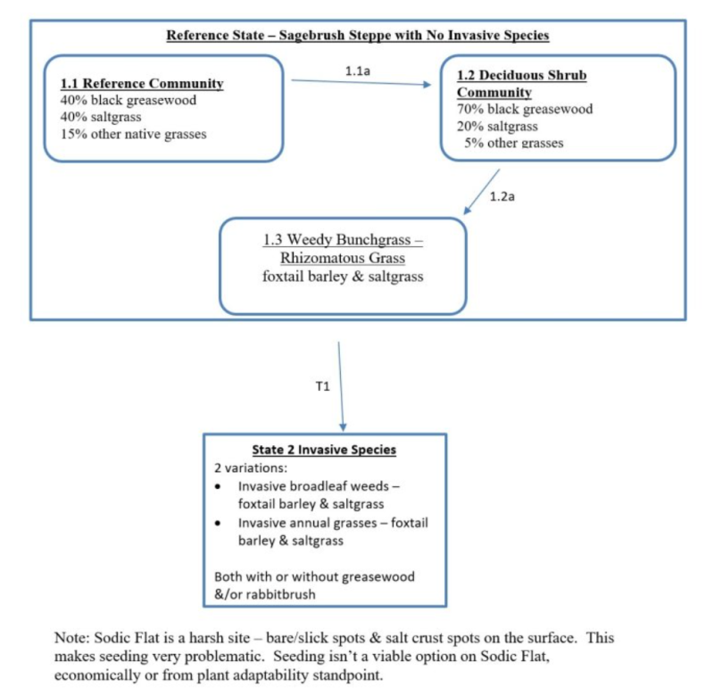
Sodic Flat ecological site has a two-layered plant community. The top-layer is scattered or patchy black greasewood, which is a three to six feet tall deciduous shrub with spines and round, narrow, fleshy leaves. The bottom layer, saltgrass, is a short, warm season rhizomatous grass. At the soil surface of the Sodic Flat ecological site is a patchy network of bare ground and saltgrass as there is no moss or lichen.
Sodic Flat ecological site is part of the lentic (standing water) ecosystem. It occurs on valley flats, bottoms, basins, terraces and depressions. This site may also occur as a narrow zonal ring around ponds and vernal pools. Soils are typically deep, clay loam and silt loam texture and have limited rock fragments (generally 10 percent or less) in the root-growing portions of the soil profile. Soils are hydric and strongly to very strongly alkaline.
Sodic Flat is a harsh ecological site. Not many plant species can tolerate the sodic conditions.
Principle Vegetative Drivers:
An elevated water table and very strongly alkaline-sodic soil chemistry drive the vegetative expression of the Sodic Flat ecological site. A limited number of plant species are adapted to the high pH. Conditions are so harsh that 40 to 80 percent of the soil surface is bare. Saltgrass is spotty and greasewood is scattered or patchy across the site.
Associated sites
| R007XY970WA |
Alkali Terrace |
|---|---|
| R007XY988WA |
Wetland Complex |
| R007XY720WA |
Riparian Complex |
| R007XY130WA |
Loamy |
| R007XY120WA |
Stony |
Similar sites
| R008XY978WA |
Sodic Flat |
|---|
Table 1. Dominant plant species
| Tree |
Not specified |
|---|---|
| Shrub |
(1) Sarcobatus vermiculatus |
| Herbaceous |
(1) Distichlis spicata |
Click on box and path labels to scroll to the respective text.