Natural Resources
Conservation Service
Ecological site R008XY630WA
Loamy grassland
Last updated: 5/23/2025
Accessed: 04/03/2026
General information
Provisional. A provisional ecological site description has undergone quality control and quality assurance review. It contains a working state and transition model and enough information to identify the ecological site.
MLRA notes
Major Land Resource Area (MLRA): 008X–Columbia Plateau
MLRA 8 encompasses about 50,100 square kilometers mainly in Washington and Oregon, with a small area in Idaho. This MLRA is characterized by loess hills, surrounding scablands, and alluvial deposits. This MLRA consists mostly of Miocene Columbia River Basalt covered with up to 200 feet of loess and volcanic ash. The dominant soil order in this MLRA is Mollisols. Soils in this MLRA dominantly have a mesic temperature regime, a xeric moisture regime, and mixed mineralogy.
Classification relationships
Major Land Resource Area (MLRA): 8 – Columbia Plateau
LRU – Common Resource Areas (CRA):
8.1 - Channeled Scablands
8.2 - Loess Islands
8.3 - Okanogan Drift Hills
8.6 - Lower Snake and Clearwater Canyons
Ecological site concept
Diagnostics:
Loamy, grassland ESD is an upland site occurring on 20 inches and deeper loamy soils on other grassland regions of MLRA 8. Soils have a loamy to sandy loam surface texture and limited rock fragments (generally 10% or less) in the root-growing portions of the soil profile. Silt loam soils are most common, but a variety of soils and landforms are possible.
Loamy, grassland is found on flat areas and west, east and south slopes.
Grassland steppe areas have not had sagebrush or bitterbrush for more than 50 years and are not expected to have either. Perennial bunchgrasses dominate the reference state. Fire-tolerant shrubs are a minor presence in the reference state, while forbs fill the interspaces. The shrub layer is typically knee- to waist-high rabbitbrush. Cool-season bunchgrasses form two distinct layers. Bluebunch wheatgrass is the dominant bunchgrass in the top grass layer, while Sandberg bluegrass is the major grass of the lower grass layer.
Principle Vegetative Drivers:
The moderately deep to deep silt loam soils drive the vegetative expression of this productive site. Most species have unrestricted rooting on this site.
Associated Sites:
Loamy Grassland is associated with other ecological sites in the MLRA 8 grassland areas of Douglas County, Asotin County and counties nearby Asotin. Associated sites include North Aspect grassland, Very Shallow, and Riparian Complex
Similar Sites:
Loamy Grassland is a bluebunch and Snake River wheatgrass ecological site. Sagebrush is not present while Idaho fescue is minor. In MLRA 8 other Loamy sites have sagebrush or much higher amounts of Idaho fescue.
Associated sites
| R008XY650WA |
Loamy North Aspect grassland |
|---|---|
| R008XY001WA |
Very Shallow |
| R008XY720WA |
Riparian Complex |
Similar sites
| R008XY536WA |
Loamy South Aspect Columbia Hills |
|---|---|
| R008XY455WA |
Loamy North Aspect 14-20 PZ Goldendale Prairie |
| R008XY130WA |
Loamy sagebrush sagebrush |
Table 1. Dominant plant species
| Tree |
Not specified |
|---|---|
| Shrub |
Not specified |
| Herbaceous |
(1) Pseudoroegneria spicata |
Physiographic features
The landscape is part of the Columbia basalt plateau. Loamy, grassland sites occur on broad ridges and plateaus, stream terraces, and east-facing hillslopes in Adams, Franklin, Walla, Walla, Asotin, Columbia, Garfield and Douglas counties
Physiographic Division: Intermontane Plateau
Physiographic Province: Columbia Plateau
Physiographic Sections: Walla Walla Plateau Section
Landscapes: Hills, valleys, scablands and plateaus
Landform: Sideslopes, terraces, till plain, ridges, alluvial fans
Table 2. Representative physiographic features
| Geomorphic position, hills |
(1) Side Slope |
|---|---|
| Landforms |
(1)
Hills
(2) Valley (3) Scabland (4) Plateau (5) Hillslope (6) Terrace (7) Till plain (8) Alluvial fan |
| Flooding frequency | None |
| Ponding frequency | None |
| Elevation | 1,200 – 3,000 ft |
| Slope | 2 – 30% |
| Water table depth | 60 in |
| Aspect | W, NW, N, NE, E, SE, S, SW |
Table 3. Representative physiographic features (actual ranges)
| Flooding frequency | Not specified |
|---|---|
| Ponding frequency | Not specified |
| Elevation | 800 – 4,000 ft |
| Slope | 65% |
| Water table depth | Not specified |
Climatic features
Grasslands do not have shrubs because they receive more spring precipitation especially in March (Daubenmire). The climate is characterized by moderately cold, wet winters, and hot, dry summers, with limited precipitation due to the rain shadow effect of the Cascades. Taxonomic soil climate is either xeric (12 – 16 inches PPT) or aridic moisture regimes (10 – 12 inches PPT) with a mesic temperature regime.
Table 4. Representative climatic features
| Frost-free period (characteristic range) | 110-160 days |
|---|---|
| Freeze-free period (characteristic range) | |
| Precipitation total (characteristic range) | 10-16 in |
| Frost-free period (actual range) | 90-210 days |
| Freeze-free period (actual range) | |
| Precipitation total (actual range) |
Influencing water features
A plant’s ability to grow on a site and overall plant production is determined by soil-water-plant relationships
1. Whether rain and melting snow runs off-site or infiltrates into the soil
2. Whether soil condition remain aerobic or become saturated and become anaerobic
3. Water drainage and how quickly the soil reaches wilting point
The Loamy, grassland site consists of deep soils and occurs for the most part on gently sloping landforms with little limitations for water infiltration. On steeper slopes and localized high silt or sodic soils, infiltration may be limited. Calcic and petrocalcic horizons may be present indicating long-term moisture penetration. There is generally no run-in moisture from surrounding sites or long-term soil moisture saturation.
Soil features
This ecological site components are dominantly Typic, Aridic, Calcic, Calcidic and Vitrandic taxonomic subgroups of Haploxerolls, Haplocambids, Durixerolls and Haploxerepts great groups of the Mollisols, Aridisols and Inceptisols taxonomic orders. Soils are moderately deep to very deep. Average available water capacity of about 7.0 inches (17.8 cm) in the 0 to 40 inches (0-100 cm) depth range.
Soil parent material is dominantly mixed loess with influence of volcanic ash possible.
The associated soils are Asotin, Chard, Ellisforde, Farrell, Magallon, Nims, Ritzville, Roloff, Siweeka, Walla Walla and similar soils.
Dominant soil surface is silt loam to loam, with ashy modifier sometimes occurring as well.
Dominant particle-size class is fine-silty to coarse-loamy.
Table 5. Representative soil features
| Parent material |
(1)
Loess
|
|---|---|
| Surface texture |
(1) Silt loam (2) Loam |
| Family particle size |
(1) Fine-silty (2) Coarse-loamy |
| Drainage class | Well drained |
| Depth to restrictive layer | 20 – 60 in |
| Soil depth | 60 in |
| Surface fragment cover <=3" | 5% |
| Surface fragment cover >3" | 5% |
| Available water capacity (0-40in) |
7 in |
| Calcium carbonate equivalent (Depth not specified) |
30% |
| Electrical conductivity (Depth not specified) |
4 mmhos/cm |
| Sodium adsorption ratio (Depth not specified) |
10 |
| Soil reaction (1:1 water) (0-10in) |
5.6 – 9 |
| Subsurface fragment volume <=3" (Depth not specified) |
10% |
| Subsurface fragment volume >3" (Depth not specified) |
10% |
Table 6. Representative soil features (actual values)
| Drainage class | Not specified |
|---|---|
| Depth to restrictive layer | Not specified |
| Soil depth | Not specified |
| Surface fragment cover <=3" | 20% |
| Surface fragment cover >3" | 10% |
| Available water capacity (0-40in) |
3.1 – 11.1 in |
| Calcium carbonate equivalent (Depth not specified) |
Not specified |
| Electrical conductivity (Depth not specified) |
Not specified |
| Sodium adsorption ratio (Depth not specified) |
Not specified |
| Soil reaction (1:1 water) (0-10in) |
Not specified |
| Subsurface fragment volume <=3" (Depth not specified) |
5 – 40% |
| Subsurface fragment volume >3" (Depth not specified) |
30% |
Ecological dynamics
Loamy Grassland produces about 750 to 1,300 pounds per acre of biomass annually.
The line between sagebrush steppe and true grasslands has been discussed and debated for many years. Daubenmire states that the line has nothing to do with pre-settlement as native ungulates played no significant role in the evolution of ecotypes. He also says that there is no evidence that the distribution of vegetative types is related to fire. And he also says there is no useful correlation between soil classification and the line between grasslands and sagebrush steppe.
The ecotones between Daubenmire’s vegetation types can be defined on the basis of consistent differences in climate and consistent differences in vegetation. Higher spring precipitation, especially in March, favors grasses over sagebrush. The grassland area of southeastern Adams and eastern Franklin counties have more precipitation in March. The same for the grasslands in Walla Walla, Asotin and Garfield counties. The Goldendale Prairie and the high elevation grassland above Coulee Dam in Douglas county also have higher spring precipitation. So, the grassland areas of MLRA 8 are consistent with Daubenmire’s findings.
Bluebunch wheatgrass is a long-lived, mid-sized bunchgrass with an awned or awnless spike seed head. Bluebunch provides a crucial and extensive network of roots to the upper portions (up to 48 inches deep in soils with no root-restrictive horizons) of the soil profile. These roots create a massive underground source to stabilize the soils, provide organic matter and nutrients inputs, and help maintain soil pore space for water infiltration and water retention in the soil profile. The extensive rooting system of mid-sized bunchgrasses leave very little soil niche space available for invasion by other species. This drought resistant root can compete, with and, suppress the spread of exotic weeds.
The stability and resiliency of the reference communities is directly linked to the health and vigor of bluebunch wheatgrass. Refer to page 8 for more details about bluebunch physiology. Research has found that the community remains resistant to medusahead if the site maintains at least 0.8 mid-sized bunchgrass plants per square foot (K. Davies, 2008). The relationship between bunchgrasses and other invasive species should be similar. It is bluebunch that holds the system together. If we lose the bluebunch the ecosystem crashes or unravels.
The natural climax condition consists of widely spaced bluebunch wheatgrass plants which allows vernal forbs to flourish, particularly in years of above-normal precipitation. Six weeks fescue and Sandberg bluegrass would have been typical early spring species. In the presence of introduced weeds and historic disturbance, native annual grasses have been replaced with a variety of invasive species which threaten the native grasslands even in absence of grazing use
The natural disturbance regime for grassland communities is periodic lightning-caused fires. The fire return intervals (FRI) listed in research for sagebrush steppe communities is quite variable. Ponderosa pine communities have the shortest FRI of about 10-20 years (Miller). The FRI increases as one moves to wetter forested sites or to dries shrub steppe
communities. Given the uncertainties and opinions of reviewers, a mean of 75 years was chosen for Wyoming sagebrush communities (Rapid Assessment Model). This would place the historic FRI for grassland steppe around 30 to 50 years
The effect of fire on the community depends upon the severity of the burn. With a light to moderate fire there can be a mosaic of burned and unburned patches. Bunchgrasses thrive as the fire does not get into the crown. With adequate soil moisture Idaho fescue and bluebunch wheatgrass can make tremendous growth the year after the fire. Largely, the community is not affected by lower intensity fire.
A severe fire puts stress on the entire community. Bluebunch wheatgrass and basin wildrye will have weak vigor for a few years but generally survive. Spots and areas that were completely sterilized are especially vulnerable to exotic invasive species. Sterilized spots must be seeded to prevent invasive species (annual grasses, tumble mustard) from totally occupying the site. Needle and thread is one native species that can increase via new seedlings.
Grazing is another common disturbance that occurs to this ecological site. Grazing pressure can be defined as heavy grazing intensity, or frequent grazing during reproductive growth, or season-long grazing (the same plants grazed more than once). As grazing pressure increases the plant community unravels in stages:
1. Cusick bluegrass, a highly desirable and palatable bunchgrass, declines and is eliminated. Adjacent native species fill the void.
2. Bluebunch wheatgrass declines while Sandberg bluegrass and needle and thread increase
3. As bluebunch continues to decline invasive species such as cheatgrass, chervil or Yellow star-thistle colonize the site
4. With further decline the site can become a community dominated by invasive species
Managing grasslands to improve the vigor and health of native bunchgrasses begins with an understanding of grass physiology. New growth each year begins from basal buds. Bluebunch wheatgrass plants rely principally on tillering, rather than establishment of new plants through natural reseeding. During seed formation, the growing points become elevated and are vulnerable to damage or removal.
If defoliated during the formation of seeds, bluebunch wheatgrass has limited capacity to tiller compared with other, more grazing resistant grasses (Caldwell et al., 1981). Repeated critical period grazing (boot stage through seed formation) is especially damaging. Over several years each native bunchgrass pasture should be rested during the critical period two out of every three years (approximately April 15 to July 15). And each
pasture should be rested the entire growing season every third year (approximately March 1 to July 15).
In the spring each year it is important to monitor and maintain an adequate top growth: (1) so plants have enough energy to replace basal buds annually, (2) to optimize regrowth following spring grazing, and (3) to protect the elevated growing points of bluebunch wheatgrass.
Bluebunch wheatgrass remains competitive if:
(1) Basal buds are replaced annually,
(2) Enough top-growth is maintained for growth and protection of growing points, and
(3) The timing of grazing and non-grazing is managed over a several-year period. Careful management of late spring grazing is especially critical
For more grazing management information refer to Range Technical Notes found in Section I Reference Lists of NRCS Field Office Technical Guide for Washington State.
In Washington, bluebunch wheatgrass communities provide habitat for many upland wildlife species.
State and transition model
More interactive model formats are also available.
View Interactive Models
More interactive model formats are also available.
View Interactive Models
Click on state and transition labels to scroll to the respective text
Ecosystem states
State 1 submodel, plant communities
State 2 submodel, plant communities
State 3 submodel, plant communities
State 1
Reference
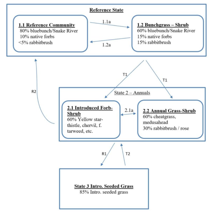
State 1 represents a grassland steppe with no invasive or exotic weed species. Grassland sites have no sagebrush and no bitterbrush. Rabbitbrush is present but a minor species in the reference State. All the functional, structural groups have one or more native species present. Reference State Communities: 1.1 Bunchgrass and 1.2 Bunchgrass and Shrub. Dominant Reference State Species: Bluebunch wheatgrass Community 1.1, the Reference Community, is stable with a high cover of Idaho fescue and bluebunch wheatgrass and low cover of rabbitbrush. Community 1.2 happens when the dominant bunchgrasses exhibit lower cover. As the bunchgrasses decline the rabbitbrush increases. At-risk Communities: • All communities in the reference state are at risk of moving to State 2. The seed source of cheatgrass, chervil and other invasive species is nearby and blowing onto most sites annually • Any community becomes at-risk of moving to State 3 when Idaho fescue and bluebunch have low vigor and annual bromes have colonized the site
Community 1.1
Bunchgrass
Community 1.1, the Reference community, is stable with a high cover of Idaho fescue and bluebunch wheatgrass with low cover of rabbitbrush. 80% bluebunch wheatgrass and Snake River wheatgrass 10% native forbs <5% rabbitbrush
Figure 1. Annual production by plant type (representative values) or group (midpoint values)
Community 1.2
Bunchgrass and Shrub
Community 1.2 happens when the dominant bunchgrasses exhibit lower cover. As the bunchgrasses decline the rabbitbrush increases. 60% bluebunch wheatgrass & Snake River wheatgrass 15% native forbs 15% rabbitbrush
Pathway 1.1A
Community 1.1 to 1.2
Result: shift from the Bunchgrass to the Bunchgrass and Shrub community. Moderate reduction in bunchgrasses and a big increase in rabbitbrush, rose and native forbs. Primary Trigger: Grazing pressure causes the bunchgrasses to decline, while shrubs gain the competitive edge. Grazing pressure is defined as heavy grazing intensity, season long grazing or frequent late spring grazing. Ecological process: consistent defoliation pressures on bluebunch wheatgrass cause poor vigor and shrinking crowns. With more and more of the upper rooting surface open, rabbitbrush, rose and forbs take advantage of the available niche space and set new seedlings Indicators: increasing canopy gaps between dominant bunchgrasses and increasing shrub canopy.
Pathway 1.2A
Community 1.2 to 1.1
Result: shift from the Bunchgrass and Shrub community to the Bunchgrass community. Rabbitbrush declines while bunchgrasses increase. Primary Trigger: periodically some unknown vector (disease, insects) causes a major rabbitbrush die-off. Ecological process: mortality to rabbitbrush leaves available niche space in the soil. With good vigor bluebunch wheatgrass expands via tillering and possibly new seedlings into the open space. Indicators: canopy gaps between dominant bunchgrasses decrease while rabbitbrush canopy increase.
State 2
Annuals
Based on opportunity, State 2 represents a community dominated by either introduced forbs or invasive annual grasses. Opportunity refers to what seed in the seedbank and moisture available from year to year. Soil disturbances by rodents or badgers allow invasive species to colonize. Bunchgrasses which were dominant in the reference state are virtually missing in State 2 and the other native, functional-structural groups have been altered. Communities for State 2: 2.1 Introduced Forb – Shrub Yellow star-thistle, etc. – Rabbitbrush 2.2 Annual Grass – Shrub Cheatgrass, etc. – Rabbitbrush Dominant Species in State 2: Annual bromes, yellow star-thistle, chervil, rabbitbrush, etc. Pathways within State 2 Result: there is a natural fluctuation between communities 2.1 and 2.2. Primary Trigger: drier years favor the annual grasses while wetter years favor the introduced forbs/weeds. Ecological process: in State 2 the seedbank of annual grasses and introduced forbs/weeds is full. In any given year one or more invasive species will have the opportunity to expand to become dominant or co-dominant. The next year a different species may have a similar opportunity.
Community 2.1
Introduced Forbs and Shrubs
60% yellow star-thistle, cherbvil, tarweed, etc.
Community 2.2
Annual Grasses and Shrubs
60% cheatgrass & medusahead 30% rabbitbrush and rose
Pathway 2.1a
Community 2.1 to 2.2
Depending on what seed is in the seedbank and precipitation, either annual grasses or introduced forbs can dominate the site.
Pathway 2.2a
Community 2.2 to 2.1
Depending on what seed is in the seedbank and precipitation, either annual grasses or introduced forbs can dominate the site.
State 3
Introduced Seeded Grasses
State 3 represents a site that has been seeded to introduced grasses such as Sherman big bluegrass, crested wheatgrass, or intermediate wheatgrass. Community for State 3: Introduced Seeded Grasses Dominant. State 3 Species: Desirable seeded grasses with or without sagebrush and legumes.
Community 3.1
Seeded Grass
85% introduced seeded grass
Transition T1A
State 1 to 2
T1 Transition from Reference state to State 2 can go two different directions. Depending on what seed is in the seedbank and precipitation, either annual grasses or introduced forbs can dominate the site. Also, in State 2 rabbitbrush and rose make a significant increase. Primary Trigger: Heavy grazing pressure (heavy grazing intensity, season long grazing or frequent late spring grazing) to bluebunch wheatgrass. Ecological process. Consistent defoliation pressure to bluebunch wheatgrass cause poor vigor and shrinking crowns. This creates opportunity for invasive species and rabbitbrush. The seedbank of annual grass seed and introduced weed seed is full. In any given year one or more invasive species will have the opportunity to become dominant or co-dominant with rabbitbrush. The next year a different invasive species may have a similar opportunity. Drier years favor annual grasses and wetter years favor invasive forbs. Indicators: increasing gaps between bluebunch wheatgrass plants. Invasive species first become established on disturbed areas and then expand to become dominant.
Restoration pathway R2A
State 2 to 1
Result: Shift from State 2 back to State 1. This restoration transition does not occur without a significant commitment of time and resource inputs to restore ecological processes, native bunchgrasses and native forb species. The only difference between R2A and R2B is the selection of species. R1A uses introduced grasses while R2B uses native grasses such as Secar Snake River wheatgrass. This restoration transition does not occur without significant time and inputs to control weeds, prepare a seedbed, seed desirable species, and post-seeding weed control and management. This requires a commitment of two years or more for weed control. Care must be taken to maintain soil structure so that the seedbed has many safe-sites for the seed. Seed placement must be managed to achieve seed-soil contact at very shallow depth (about 1/8 inch is desired). Proper grazing management is essential to maintain the stand post-seeding. Secar Snake River wheatgrass and Sandberg bluegrass are typical native grasses seeded on Loamy ecological site. Re-establishing the native forbs is much more problematic. Marginal success has been the result of two different methods: (1) seeding native grass and forbs at the same time, (2) seeding native grasses one year and then coming back the following year to seed the native forbs. The actual transition occurs when the seeded species have successfully established and are outcompeting the annual species for cover and dominance of resources.
Restoration pathway R2B
State 2 to 3
Transition from State 2 (a community dominated by invasive annual species) to State 3, which is predominately introduced seeded grasses. This restoration transition does not occur without significant time and inputs to control weeds, prepare a seedbed, seed desirable species, and post-seeding weed control and management. This requires a commitment of two years or more for weed control. Care must be taken to maintain soil structure so that the seedbed has many safe-sites for the seed. Seed placement must be managed to achieve seed-soil contact at very shallow depth (about 1/8 inch is desired). Proper grazing management is essential to maintain the stand post-seeding. Sherman big bluegrass, crested wheatgrass, and intermediate wheatgrass are typical species seeded on Loamy ecological site. The actual transition occurs when the seeded species have successfully established and are outcompeting the annual species for cover and dominance of resources.
Transition T3A
State 3 to 2
Result: shift from seeded grass State 3 to State 2 which is dominated by invasive annual species. Primary Trigger: Chronic heavy grazing pressure (heavy grazing intensity, season long grazing or frequent late spring grazing) to seeded grasses. Ecological process: Consistent defoliation pressure to bluebunch wheatgrass cause poor vigor, shrinking crowns and mortality. This creates opportunity for invasive species and rabbitbrush. The seedbank of annual grass seed and introduced weed seed is full. In any given year one or more invasive species will have the opportunity to become dominant or co-dominant with rabbitbrush. The next year a different invasive species may have a similar opportunity. Little of the resources remain for the desirable species. Indicators: shrinking crowns and mortality of desirable species, increasing caps gaps between perennial species, increasing cover by annual grasses and increasing canopy by rabbitbrush/rose.
Additional community tables
Table 7. Community 1.1 plant community composition
| Group | Common name | Symbol | Scientific name | Annual production (lb/acre) | Foliar cover (%) | |
|---|---|---|---|---|---|---|
|
Shrub/Vine
|
||||||
| 1 | Sprouting Shrubs - Minor | 50– | ||||
| rabbitbrush | CHRYS9 | Chrysothamnus | – | – | ||
| currant | RIBES | Ribes | – | – | ||
| rose | ROSA5 | Rosa | – | – | ||
|
Grass/Grasslike
|
||||||
| 2 | Dominant Mid-Size Bunchgrass | 1050– | ||||
| bluebunch wheatgrass | PSSP6 | Pseudoroegneria spicata | – | – | ||
| Snake River wheatgrass | ELWA2 | Elymus wawawaiensis | – | – | ||
| 3 | Other Mid-Size Bunchgrasses - Minor | 50– | ||||
| squirreltail | ELEL5 | Elymus elymoides | – | – | ||
| Thurber's needlegrass | ACTH7 | Achnatherum thurberianum | – | – | ||
| needle and thread | HECO26 | Hesperostipa comata | – | – | ||
| Idaho fescue | FEID | Festuca idahoensis | – | – | ||
| Cusick's bluegrass | POCU3 | Poa cusickii | – | – | ||
| Columbia needlegrass | ACNE9 | Achnatherum nelsonii | – | – | ||
| prairie Junegrass | KOMA | Koeleria macrantha | – | – | ||
| 4 | Short Grass - Minor | 125– | ||||
| Sandberg bluegrass | POSE | Poa secunda | – | – | ||
| 5 | Other Graminoids - Trace | 0– | ||||
| threadleaf sedge | CAFI | Carex filifolia | – | – | ||
|
Forb
|
||||||
| 6 | Native Forbs - Minor | 125– | ||||
| common yarrow | ACMI2 | Achillea millefolium | – | – | ||
| arrowleaf balsamroot | BASA3 | Balsamorhiza sagittata | – | – | ||
| lupine | LUPIN | Lupinus | – | – | ||
| hawksbeard | CREPI | Crepis | – | – | ||
| longleaf phlox | PHLO2 | Phlox longifolia | – | – | ||
| spiny phlox | PHHO | Phlox hoodii | – | – | ||
| granite prickly phlox | LIPU11 | Linanthus pungens | – | – | ||
| buckwheat | ERIOG | Eriogonum | – | – | ||
| Indian paintbrush | CASTI2 | Castilleja | – | – | ||
| trumpet | COLLO | Collomia | – | – | ||
| yellow fritillary | FRPU2 | Fritillaria pudica | – | – | ||
| fleabane | ERIGE2 | Erigeron | – | – | ||
| desertparsley | LOMAT | Lomatium | – | – | ||
| milkvetch | ASTRA | Astragalus | – | – | ||
| hawkweed | HIERA | Hieracium | – | – | ||
| low pussytoes | ANDI2 | Antennaria dimorpha | – | – | ||
| mariposa lily | CALOC | Calochortus | – | – | ||
| silverpuffs | MICRO6 | Microseris | – | – | ||
| woolly plantain | PLPA2 | Plantago patagonica | – | – | ||
| western stoneseed | LIRU4 | Lithospermum ruderale | – | – | ||
| larkspur | DELPH | Delphinium | – | – | ||
Interpretations
Supporting information
Other references
Boling M., Frazier B., Busacca, A., General Soil Map of Washington, Washington State University, 1998 Daubenmire, R., Steppe Vegetation of Washington, EB1446, March 1968
Davies, Kirk, Medusahead Dispersal and Establishment in Sagebrush Steppe Plant Communities, Rangeland Ecology & Management, 2008 Environmental Protection Agency, map of Level III and IV Ecoregions of Washington, June 2010
Miller, Baisan, Rose and Pacioretty, “Pre and Post Settlement Fire regimes in mountain Sagebrush communities: The Northern Intermountain Region Natural Resources Conservation Service, map of Common Resource Areas of Washington, 2003 Rapid Assessment Reference Condition Model for Wyoming sagebrush, LANDFIRE project, 2008
Rocchio, Joseph & Crawford, Rex C., Ecological Systems of Washington State. A Guide to Identification. Washington State Department of Natural Resources, October 2015. Pages 156-161 Inter-Mountain Basin Big Sagebrush.
Rouse, Gerald, MLRA 8 Ecological Sites as referenced from Natural Resources Conservation Service-Washington FOTG, 2004 Soil Conservation Service, Range Sites for MLRA 8 from 1980s and 1990s
Tart, D., Kelley, P., and Schlafly, P., Rangeland Vegetation of the Yakima Indian reservation, August 1987, YIN Soil and Vegetation Survey.
Contributors
Kevin Guinn
Approval
Kirt Walstad, 5/23/2025
Acknowledgments
Provisional Site Author: Kevin Guinn
Technical Team: K. Moseley, G. Fults, R. Fleenor, W. Keller, C. Smith, K. Bomberger, C. Gaines, K. Paup-Lefferts
Rangeland health reference sheet
Interpreting Indicators of Rangeland Health is a qualitative assessment protocol used to determine ecosystem condition based on benchmark characteristics described in the Reference Sheet. A suite of 17 (or more) indicators are typically considered in an assessment. The ecological site(s) representative of an assessment location must be known prior to applying the protocol and must be verified based on soils and climate. Current plant community cannot be used to identify the ecological site.
| Author(s)/participant(s) | |
|---|---|
| Contact for lead author | |
| Date | 05/08/2025 |
| Approved by | Kirt Walstad |
| Approval date | |
| Composition (Indicators 10 and 12) based on | Annual Production |
Indicators
-
Number and extent of rills:
-
Presence of water flow patterns:
-
Number and height of erosional pedestals or terracettes:
-
Bare ground from Ecological Site Description or other studies (rock, litter, lichen, moss, plant canopy are not bare ground):
-
Number of gullies and erosion associated with gullies:
-
Extent of wind scoured, blowouts and/or depositional areas:
-
Amount of litter movement (describe size and distance expected to travel):
-
Soil surface (top few mm) resistance to erosion (stability values are averages - most sites will show a range of values):
-
Soil surface structure and SOM content (include type of structure and A-horizon color and thickness):
-
Effect of community phase composition (relative proportion of different functional groups) and spatial distribution on infiltration and runoff:
-
Presence and thickness of compaction layer (usually none; describe soil profile features which may be mistaken for compaction on this site):
-
Functional/Structural Groups (list in order of descending dominance by above-ground annual-production or live foliar cover using symbols: >>, >, = to indicate much greater than, greater than, and equal to):
Dominant:
Sub-dominant:
Other:
Additional:
-
Amount of plant mortality and decadence (include which functional groups are expected to show mortality or decadence):
-
Average percent litter cover (%) and depth ( in):
-
Expected annual annual-production (this is TOTAL above-ground annual-production, not just forage annual-production):
-
Potential invasive (including noxious) species (native and non-native). List species which BOTH characterize degraded states and have the potential to become a dominant or co-dominant species on the ecological site if their future establishment and growth is not actively controlled by management interventions. Species that become dominant for only one to several years (e.g., short-term response to drought or wildfire) are not invasive plants. Note that unlike other indicators, we are describing what is NOT expected in the reference state for the ecological site:
-
Perennial plant reproductive capability:
Print Options
Sections
Font
Other
The Ecosystem Dynamics Interpretive Tool is an information system framework developed by the USDA-ARS Jornada Experimental Range, USDA Natural Resources Conservation Service, and New Mexico State University.
Click on box and path labels to scroll to the respective text.