
Natural Resources
Conservation Service
Ecological site R008XY650WA
Loamy North Aspect grassland
Last updated: 5/23/2025
Accessed: 07/12/2025
General information
Provisional. A provisional ecological site description has undergone quality control and quality assurance review. It contains a working state and transition model and enough information to identify the ecological site.
MLRA notes
Major Land Resource Area (MLRA): 008X–Columbia Plateau
MLRA 8 encompasses about 50,100 square kilometers mainly in Washington and Oregon, with a small area in Idaho. This MLRA is characterized by loess hills, surrounding scablands, and alluvial deposits. This MLRA consists mostly of Miocene Columbia River Basalt covered with up to 200 feet of loess and volcanic ash. The dominant soil order in this MLRA is Mollisols. Soils in this MLRA dominantly have a mesic temperature regime, a xeric moisture regime, and mixed minerology.
Classification relationships
Major Land Resource Area (MLRA): 8 – Columbia Plateau
LRU – Common Resource Areas (CRA):
8.1 - Channeled Scablands
8.2 - Loess Islands
8.3 - Okanogan Drift Hills
8.6 - Lower Snake and Clearwater Canyons
Ecological site concept
Note: for MLRA 8 there are two ecological sites with the name ‘North Aspect’:
1. One specifically for grasslands on the Goldendale Prairie (Klickitat Co.)
2. One for other grassland areas in MLRA 8 including
a. SE portion of MLRA 8 includes portions of Adams, Franklin, Walla Wall, Asotin, Columbia and Garfield counties
b. Elevations about 2400 feet in northern Douglas county including Dyer Hill and Wilson Butte
Loamy, north aspect, grassland PES below is for other grassland areas in MLRA 8 including Adams, Franklin, Walla Walla, Columbia, Garfield and Douglas counties.
Diagnostics:
Loamy, north aspect, grassland occurs on north to northeast facing slopes on other grassland steppe regions of MLRA 8. This site is found on both stony and non-stony soils that are 20 inches and deeper. The most common textures are loam, silt loam and sandy loam.
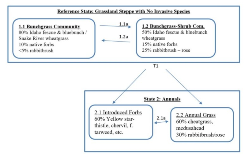
Grassland steppe areas have not had sagebrush or bitterbrush for more than 50 years and are not expected to have either. Perennial bunchgrasses dominate the reference state. Fire-tolerant rabbitbrush is a minor presence in the reference state, while forbs fill the interspaces. The shrub layer is typically knee- to waist-high rabbitbrush.
Cool-season bunchgrasses form two distinct layers. On North Slope sites, Idaho fescue is the dominant species and bluebunch wheatgrass is sub-dominant in the top grass layer. Sandberg bluegrass is the major grass of the lower grass layer.
Principle Vegetative Drivers:
The vegetative expression of this productive site is driven by two factors: (1) moderately deep to deep soil depth provides unrestricted rooting for most species, and (2) the north aspect which has more effective precipitation. This ecological site has cooler temperatures year-round and longer lasting snow-pack than adjacent ecological sites. North Slope provides crucial water to the vegetation at the hottest time of the growing season allowing this ecological site more resilience when impacted by disturbances. Also, being wetter and cooler, North Slope supports a denser plant cover, more litter and more biological crusts than the Loamy ecological site.
Associated Sites:
North Aspect Grassland is associated with Loamy grassland. Very Shallow, Loamy Bottom and Riparian Complex may also be nearby.
Similar Sites:
North Aspect Grassland is dominated by Idaho fescue with bluebunch wheatgrass second. North Aspect Goldendale Prairie has a similar composition and production. Sagebrush Steppe Cool Loamy has threetip sage but otherwise is similar to North Aspect, grassland.
Associated sites
R008XY630WA |
Loamy grassland |
---|---|
R008XY930WA |
Loamy Bottom |
R008XY001WA |
Very Shallow |
R008XY720WA |
Riparian Complex |
Similar sites
R008XY455WA |
Loamy North Aspect 14-20 PZ Goldendale Prairie |
---|---|
R008XY153WA |
Cool Loamy threetip sagebrush |
Table 1. Dominant plant species
Tree |
Not specified |
---|---|
Shrub |
Not specified |
Herbaceous |
(1) Festuca idahoensis |
Physiographic features
The landscape is part of the Columbia basalt plateau. Loamy, north aspect, grassland sites are most commonly found on north to northeastern slopes of canyons, ridges, mountains and hills throughout the Columbia Plateau in Adams, Franklin, Walla, Walla, Asotin, Columbia, Garfield and Douglas counties. Topographic position may be more important than parent material in defining this site.
Physiographic Division: Intermontane Plateau
Physiographic Province: Columbia Plateau
Physiographic Sections: Walla Walla Plateau Section
Landscapes: Hills, canyons and plateaus
Landform: Sideslopes, terraces, escarpments terraces
Table 2. Representative physiographic features
Geomorphic position, hills |
(1) Side Slope |
---|---|
Landforms |
(1)
Hills
(2) Canyonlands (3) Plateau (4) Terrace (5) Hillslope |
Flooding frequency | None |
Ponding frequency | None |
Elevation | 1,200 – 2,500 ft |
Slope | 15 – 65% |
Water table depth | 60 in |
Aspect | NW, N, NE |
Table 3. Representative physiographic features (actual ranges)
Flooding frequency | Not specified |
---|---|
Ponding frequency | Not specified |
Elevation | 400 – 3,000 ft |
Slope | 5 – 90% |
Water table depth | Not specified |
Climatic features
Grasslands do not have shrubs because they receive more spring precipitation especially in March (Daubenmire). The micro-climate on the north facing slopes provides cooler temperatures and allows Idaho fescue to dominate. The climate is characterized by moderately cold, wet winters, and hot, dry summers, with limited precipitation due to the rain shadow effect of the Cascades. Taxonomic soil climate is either xeric (12 to 16 inches PPT) or aridic moisture regimes (10 to 12 inches PPT) with a mesic temperature regime.
Table 4. Representative climatic features
Frost-free period (characteristic range) | 110-160 days |
---|---|
Freeze-free period (characteristic range) | |
Precipitation total (characteristic range) | 10-16 in |
Frost-free period (actual range) | 100-180 days |
Freeze-free period (actual range) | |
Precipitation total (actual range) |
Influencing water features
A plant’s ability to grow on a site and overall plant production is determined by soil-water-plant relationships
1. Whether rain and melting snow runs off-site or infiltrates into the soil
2. Whether soil condition remain aerobic or become saturated and become anaerobic
3. Water drainage and how quickly the soil reaches wilting point
The Loamy, north aspect, grassland site is cooler and moister than surrounding sites due to microclimatic effects. North slopes have less direct solar radiation and reduced evapotranspiration than adjacent uplands or south facing slopes and may retain snow cover longer into the growing season. Deep soils on the north slopes and extensive subsurface root systems of the dominant grasses also provide greater soil moisture infiltration and retention compared with other areas.
Soil features
This ecological site components are dominantly Typic, Aridic and Calcic taxonomic subgroups of Haploxerolls, Haplocambids and Natrixerolls great groups of the Mollisols taxonomic order. Soils are moderately deep to very deep. Average available water capacity of about seven inches (17.8 cm) in the zero to 40 inches (zero to 100 cm) depth range.
Soil parent material is dominantly mixed loess and colluvium, with influence of volcanic ash possible.
The associated soils are Asotin, Chard, Magallon, Nansense, Oliphant, Ritzville, Walla Walla and similar soils.
Dominate soil surface is silt loam to loam, with ashy modifier sometimes occurring as well.
Dominant particle-size class is fine to sandy.
Table 5. Representative soil features
Parent material |
(1)
Loess
(2) Colluvium |
---|---|
Surface texture |
(1) Silt loam (2) Loam |
Family particle size |
(1) Fine (2) Sandy |
Drainage class | Well drained |
Depth to restrictive layer | 20 – 60 in |
Soil depth | 60 in |
Surface fragment cover <=3" | 5% |
Surface fragment cover >3" | 2% |
Available water capacity (0-40in) |
7 in |
Calcium carbonate equivalent (Depth not specified) |
30% |
Electrical conductivity (Depth not specified) |
4 mmhos/cm |
Sodium adsorption ratio (Depth not specified) |
10 |
Soil reaction (1:1 water) (0-10in) |
6.1 – 9 |
Subsurface fragment volume <=3" (Depth not specified) |
10% |
Subsurface fragment volume >3" (Depth not specified) |
5% |
Table 6. Representative soil features (actual values)
Drainage class | Not specified |
---|---|
Depth to restrictive layer | Not specified |
Soil depth | Not specified |
Surface fragment cover <=3" | 20% |
Surface fragment cover >3" | 10% |
Available water capacity (0-40in) |
3.1 – 8.3 in |
Calcium carbonate equivalent (Depth not specified) |
Not specified |
Electrical conductivity (Depth not specified) |
Not specified |
Sodium adsorption ratio (Depth not specified) |
Not specified |
Soil reaction (1:1 water) (0-10in) |
Not specified |
Subsurface fragment volume <=3" (Depth not specified) |
5 – 30% |
Subsurface fragment volume >3" (Depth not specified) |
20% |
Ecological dynamics
Loamy, north aspect, grassland produces about 900 to 1,600 pounds per acre of above-ground biomass annually
The line between sagebrush steppe and true grasslands has been discussed and debated for many years. Daubenmire states that the line has nothing to do with pre-settlement as native ungulates played no significant role in the evolution of ecotypes. He also says that there is no evidence that the distribution of vegetative types is related to fire. And he also says there is no useful correlation between soil classification and the line between grasslands and sagebrush steppe.
The ecotones between Daubenmire’s vegetation types can be defined on the basis of consistent differences in climate and consistent differences in vegetation. Higher spring precipitation, especially in March, favors grasses over sagebrush. The grassland area of southeastern Adams and eastern Franklin counties have more precipitation in March. The same for the grasslands in Walla Walla, Asotin and Garfield counties. The Goldendale Prairie and the high elevation grassland above Coulee Dam in Douglas county also have higher spring precipitation. So, the grassland areas of MLRA 8 are consistent with Daubenmire’s findings.
On the Loamy, north aspect, grassland ecological site, Idaho fescue is dominant while bluebunch is sub-dominant. The presence and relative abundance of Idaho fescue is an indicator of the comparatively mesic environment for this site. Idaho fescue is shorter and has a dense clump of shoots, while bluebunch wheatgrass is taller and is less dense. Both species are long-lived bunchgrasses. Bluebunch has an awned spike seed head while Idaho fescue has an awned panicle seed head. The ratio of Idaho fescue to bluebunch wheatgrass plants on any site can vary due to aspect and elevation.
Both grasses provide a crucial and extensive network of roots to the upper portions (up to 48” deep in soils with no root-restrictive horizons) of the soil profile. These roots create a massive underground network to stabilize the soils, provide organic matter and nutrients inputs, and help maintain soil pore space for water infiltration and water retention in the soil profile. The extensive rooting system of mid-sized bunchgrasses leave very little soil niche space available for invasion by other species. This drought resistant root system can compete with, and, suppress the spread of exotic weeds.
The stability and resiliency of the reference communities is directly linked to the health and vigor of Idaho fescue and bluebunch wheatgrass. Refer to page 8 for more details about bunchgrass physiology. Research has found that the community remains resistant to medusahead if the site maintains at least 0.8 mid-sized bunchgrass plant/sq. ft. (K. Davies, 2008). The relationship between bunchgrasses and other invasive species should be similar. These two bunchgrasses hold the system together. If we lose either or both bunchgrass the ecosystem begins to unravel.
The natural disturbance regime for grassland communities is periodic lightning-caused fires. The fire return intervals (FRI) listed in research for sagebrush steppe communities is quite variable. Ponderosa pine communities have the shortest FRI of about 10 to 20 years (Miller). The FRI increases as one moves to wetter forested sites or to dries shrub steppe
communities. Given the uncertainties and opinions of reviewers, a mean of 75 years was chosen for Wyoming sagebrush communities (Rapid Assessment Model). This would place the historic FRI for grassland steppe around 30 to 50 years
The effect of fire on the community depends upon the severity of the burn. With a light to moderate fire there can be a mosaic of burned and unburned patches. Bunchgrasses thrive as the fire does not get into the crown. Idaho fescue and bluebunch wheatgrass exhibit rapid tillering when there is light severity fires and favorable soil moisture. Rabbitbrush and horsebrush are sprouting shrubs and may increase following fire. Largely, the community is not affected by lower intensity fire.
A severe fire puts stress on the entire community. Some spots and areas can be completely sterilized. Under windy conditions, a fire can burn into the crown of Idaho fescue, leaving behind “black holes” or nothing but ash. Sterilized spots and dead Idaho fescue plants makes the site vulnerable to exotic invasive species. Seeding should be strongly be considered. Bluebunch wheatgrass and basin wildrye will have weak vigor for a few years but generally survive. Bluebunch wheatgrass keeps the site resistant to change, while Idaho fescue makes the site more at risk.
Spring burning can be especially damaging to Idaho fescue.
Grazing is another common disturbance that occurs to this ecological site. Grazing pressure can be defined as heavy grazing intensity, or frequent grazing during reproductive growth, or season-long grazing (the same plants grazed more than once). As grazing pressure increases the plant community unravels in stages:
1. Cusick bluegrass is eliminated. Adjacent natives fill the void
2. Idaho fescue declines while bluebunch wheatgrass increases
3. Both Idaho fescue and bluebunch wheatgrass decline while threadleaf sedge increases
4. With further decline invasive species such as cheatgrass, chervil or yellow star-thistle colonize the site
5. With further decline the site can become a community dominated by invasive species
Managing grasslands to improve the vigor and health of native bunchgrasses begins with an understanding of grass physiology. New growth each year begins from basal buds. Given the opportunity Idaho fescue readily produces new seedlings while bluebunch wheatgrass plants rely principally on tillering. During seed formation, the growing points of bluebunch wheatgrass become elevated and are vulnerable to damage or removal. Idaho fescue has weak stems and is much more sensitive to grazing than bluebunch wheatgrass.
If defoliated during the formation of seeds, bluebunch wheatgrass has limited capacity to tiller compared with other, more grazing resistant grasses (Caldwell et al., 1981). Repeated critical period grazing is especially damaging. Over several years each native bunchgrass pasture should be rested during the critical period two out of every three years (approximately April 15 to July 15). And each pasture should be rested the entire growing season every third year (approximately March 1 to July 15).
In the spring each year it is important to monitor and maintain an adequate top growth: (1) so plants have enough energy to replace basal buds annually, (2) to optimize regrowth following spring grazing, (3) to protect the elevated growing points of bluebunch wheatgrass, and (4) to avoid excessing defoliation of Idaho fescue with its weak stems.
These grasses remain competitive if:
(1) Basal buds are replaced annually,
(2) Enough top-growth is maintained for growth and protection of growing points, and
(3) The timing of grazing and non-grazing is managed over a several-year period. Careful management of late spring grazing is especially critical
For more grazing management information refer to Range Technical Notes found in Section I Reference Lists of NRCS Field Office Technical Guide for Washington State.
In Washington, Idaho fescue – bluebunch wheatgrass communities provide habitat for a variety of upland wildlife species.
State and transition model

More interactive model formats are also available.
View Interactive Models
More interactive model formats are also available.
View Interactive Models
Click on state and transition labels to scroll to the respective text
Ecosystem states
State 1 submodel, plant communities
State 2 submodel, plant communities
State 1
Reference Grassland Steppe
State 1 represents grassland steppe with no invasive or exotic weed species. Grassland sites have no sagebrush and no bitterbrush. Rabbitbrush is present but a minor species in the reference State. All the functional, structural groups have one or more native species present. Reference State Community Phases: 1.1 Bunchgrass and 1.2 Bunchgrass and Shrub Community 1.1 , the reference Community is stable with a high cover of Idaho fescue and bluebunch wheatgrass with low cover of rabbitbrush. Community 1.2 happens when the dominant bunchgrasses exhibit lower cover. As the bunchgrasses decline the rabbitbrush increases. Dominant Reference State Species: Idaho fescue with bluebunch wheatgrass as sub-dominant At-risk Communities: • All communities in the reference state are at risk of moving to State 2. The seed source of cheatgrass, chervil and other invasive species is nearby and blowing onto most sites annually • Any community becomes at-risk of moving to State 3 when Idaho fescue and bluebunch have low vigor and annual bromes have colonized the site • Any Loamy North Aspect community is at risk when fire kills Idaho fescue plants. The holes could quickly be filled by annual grass or invasive forbs.
Community 1.1
Bunchgrass
Community 1.1 , the Reference community is stable with a high cover of Idaho fescue, bluebunch wheatgrass, Snake River wheatgrass, native forbs, and low cover of rabbitbrush. 80% Idaho fescue, bluebunch wheatgrass, and Snake River wheatgrass 10% native forbs <5% rabbitbrush
Figure 1. Annual production by plant type (representative values) or group (midpoint values)
Community 1.2
Bunchgrass and Shrub
Community 1.2 happens when the dominant bunchgrasses exhibit lower cover. As the bunchgrasses decline the rabbitbrush increases. 50% Idaho fescue & bluebunch wheatgrass 15% native forbs 25% rabbitbrush & rose
Pathway 1.1A
Community 1.1 to 1.2
Result: shift from the Bunchgrass community to the Bunchgrass and Shrub community. Moderate reduction in bunchgrasses and a moderate increase in rabbitbrush, rose and native forbs Primary Trigger: Grazing pressure causes the bunchgrasses to decline, while shrubs gain the competitive edge. Grazing pressure is defined as heavy grazing intensity, season long grazing or frequent late spring grazing. Ecological process: consistent defoliation pressures on bluebunch wheatgrass cause poor vigor and shrinking crowns. With more and more of the upper rooting surface open, rabbitbrush and rose take advantage of the available niche space and set new seedlings Indicators: increasing canopy gaps between dominant bunchgrasses and increasing shrub canopy.
Pathway 1.2A
Community 1.2 to 1.1
Result: shift from the Bunchgrass and Shrub community to the Bunchgrass community. Rabbitbrush declines while bunchgrasses increase Primary Trigger: periodically some unknown vector (disease, insects) causes a major rabbitbrush die-off. Ecological process: mortality to rabbitbrush leaves available niche space in the soil. With good vigor Idaho fescue and other bunchgrasses expand via tillering and new seedlings into the open space. Indicators: canopy gaps between dominant bunchgrasses decrease while rabbitbrush canopy increase.
State 2
Invaded
Based on opportunity, State 2 is dominated by either introduced forbs or invasive annual grasses. Opportunity refers to what seed in the seedbank and moisture available from year to year. Soil disturbances by rodents or badgers allow invasive species to colonize. In State 2 bunchgrasses which were dominant in the reference state are virtually missing and the other native, functional-structural groups have been altered. Communities for State 2: 2.1 Introduced Forbs and 2.2 Annual Grasses Dominant Species in State 2: Annual bromes, yellow star-thistle, chervil, rabbitbrush Pathways within State 2 Result: there is a natural fluctuation between communities 2.1 and 2.2. Primary Trigger: drier years favor the annual grasses while wetter years favor the introduced forbs and weeds Ecological process: in State 2 the seedbank of annual grasses and introduced forbs and weeds is full. In any given year one or more invasive species will have the opportunity to expand to become dominant or co-dominant. The next year a different species may have a similar opportunity.
Community 2.1
Introduced Forbs
60% yellow star-thistle, chervil, tarweed, etc.
Community 2.2
Annual Grasses
60% cheatgrass & medusahead 30% rabbitbrush & rose
Pathway 2.1A
Community 2.1 to 2.2
Seedbank is dominated by annual grasses. Invasive grasses outcompete invasive forbs. Broadleaf herbicide treatment of invasive forbs may also lead to increase of invasive grasses. This pathway can be cyclical based on seed production.
Pathway 2.2A
Community 2.2 to 2.1
Seedbank is dominated by invasive forbs. Invasive forbs outcompete invasive grasses. This pathway is cyclical based on seed production.
Transition T1A
State 1 to 2
The transition from Reference statee to State 2 can go two different directions. Depending on seed in the seedbank and precipitation, either annual grasses or introduced forbs can dominate the site. Also, in State 2 rabbitbrush and rose make a significant increase. Primary Trigger: Heavy grazing pressure (heavy grazing intensity, season long grazing or frequent late spring grazing) to Idaho fescue and bluebunch wheatgrass. Ecological process. Consistent defoliation pressure to Idaho fescue and bluebunch wheatgrass cause poor vigor and shrinking crowns. This creates opportunity for invasive species and rabbitbrush. The seedbank of annual grass seed and introduced weed seed is full. In any given year one or more invasive species will have the opportunity to expand to become dominant or co-dominant with rabbitbrush. The next year a different invasive species may have a similar opportunity. Drier years favor annual grasses and wetter years favor invasive forbs. Indicators: increasing gaps between dominant bunchgrasses (Idaho fescue and bluebunch wheatgrass). Invasive species first become established on disturbed areas and then expand to become dominant.
Restoration pathway R2A
State 2 to 1
Seeding is not an option for Loamy North Aspect grassland as most locations are too steep to seed.
Additional community tables
Table 7. Community 1.1 plant community composition
Group | Common name | Symbol | Scientific name | Annual production (lb/acre) | Foliar cover (%) | |
---|---|---|---|---|---|---|
Shrub/Vine
|
||||||
1 | Sprouting Shrubs - Minor | 50– | ||||
rabbitbrush | CHRYS9 | Chrysothamnus | – | – | ||
currant | RIBES | Ribes | – | – | ||
rose | ROSA5 | Rosa | – | – | ||
Grass/Grasslike
|
||||||
2 | Dominant Mid-Size Bunchgrasses | 1300– | ||||
Idaho fescue | FEID | Festuca idahoensis | 900– | – | ||
bluebunch wheatgrass | PSSP6 | Pseudoroegneria spicata | 400– | – | ||
Snake River wheatgrass | ELWA2 | Elymus wawawaiensis | – | – | ||
3 | Other Mid-Size Bunchgrasses - Minor | 50– | ||||
Cusick's bluegrass | POCU3 | Poa cusickii | – | – | ||
prairie Junegrass | KOMA | Koeleria macrantha | – | – | ||
basin wildrye | LECI4 | Leymus cinereus | – | – | ||
Columbia needlegrass | ACNE9 | Achnatherum nelsonii | – | – | ||
4 | Short Grass - Minor | 80– | ||||
Sandberg bluegrass | POSE | Poa secunda | – | – | ||
sixweeks fescue | VUOC | Vulpia octoflora | – | – | ||
5 | Other Graminoids - Trace | 0– | ||||
Forb
|
||||||
6 | Native Forbs- Minor | 160– | ||||
common yarrow | ACMI2 | Achillea millefolium | – | – | ||
arrowleaf balsamroot | BASA3 | Balsamorhiza sagittata | – | – | ||
lupine | LUPIN | Lupinus | – | – | ||
hawksbeard | CREPI | Crepis | – | – | ||
longleaf phlox | PHLO2 | Phlox longifolia | – | – | ||
spiny phlox | PHHO | Phlox hoodii | – | – | ||
desertparsley | LOMAT | Lomatium | – | – | ||
milkvetch | ASTRA | Astragalus | – | – | ||
low pussytoes | ANDI2 | Antennaria dimorpha | – | – | ||
trumpet | COLLO | Collomia | – | – | ||
woolly plantain | PLPA2 | Plantago patagonica | – | – | ||
yellow fritillary | FRPU2 | Fritillaria pudica | – | – | ||
silverpuffs | MICRO6 | Microseris | – | – | ||
onion | ALLIU | Allium | – | – | ||
mariposa lily | CALOC | Calochortus | – | – | ||
fleabane | ERIGE2 | Erigeron | – | – | ||
granite prickly phlox | LIPU11 | Linanthus pungens | – | – | ||
buckwheat | ERIOG | Eriogonum | – | – | ||
Indian paintbrush | CASTI2 | Castilleja | – | – | ||
hawkweed | HIERA | Hieracium | – | – | ||
larkspur | DELPH | Delphinium | – | – | ||
western stoneseed | LIRU4 | Lithospermum ruderale | – | – |
Interpretations
Supporting information
Other references
Boling M., Frazier B., Busacca, A., General Soil Map of Washington, Washington State University, 1998 Daubenmire, R., Steppe Vegetation of Washington, EB1446, March 1968
Davies, Kirk, Medusahead Dispersal and Establishment in Sagebrush Steppe Plant Communities, Rangeland Ecology & Management, 2008 Environmental Protection Agency, map of Level III and IV Ecoregions of Washington, June 2010
Miller, Baisan, Rose and Pacioretty, “Pre and Post Settlement Fire regimes in mountain Sagebrush communities: The Northern Intermountain Region Natural Resources Conservation Service, map of Common Resource Areas of Washington, 2003 Rapid Assessment Reference Condition Model for Wyoming sagebrush, LANDFIRE project, 2008
Rocchio, Joseph & Crawford, Rex C., Ecological Systems of Washington State. A Guide to Identification. Washington State Department of Natural Resources, October 2015. Pages 156-161 Inter-Mountain Basin Big Sagebrush.
Rouse, Gerald, MLRA 8 Ecological Sites as referenced from Natural Resources Conservation Service-Washington FOTG, 2004 Soil Conservation Service, Range Sites for MLRA 8 from 1980s and 1990s
Tart, D., Kelley, P., and Schlafly, P., Rangeland Vegetation of the Yakima Indian reservation, August 1987, YIN Soil and Vegetation Survey.
Contributors
Kevin Guinn
Approval
Kirt Walstad, 5/23/2025
Acknowledgments
Contributors
Provisional Site Author: Kevin Guinn
Technical Team: K. Moseley, G. Fults, R. Fleenor, W. Keller, C. Smith, K. Bomberger, C. Gaines, K. Paup-Lefferts
Rangeland health reference sheet
Interpreting Indicators of Rangeland Health is a qualitative assessment protocol used to determine ecosystem condition based on benchmark characteristics described in the Reference Sheet. A suite of 17 (or more) indicators are typically considered in an assessment. The ecological site(s) representative of an assessment location must be known prior to applying the protocol and must be verified based on soils and climate. Current plant community cannot be used to identify the ecological site.
Author(s)/participant(s) | |
---|---|
Contact for lead author | |
Date | 05/08/2025 |
Approved by | Kirt Walstad |
Approval date | |
Composition (Indicators 10 and 12) based on | Annual Production |
Indicators
-
Number and extent of rills:
-
Presence of water flow patterns:
-
Number and height of erosional pedestals or terracettes:
-
Bare ground from Ecological Site Description or other studies (rock, litter, lichen, moss, plant canopy are not bare ground):
-
Number of gullies and erosion associated with gullies:
-
Extent of wind scoured, blowouts and/or depositional areas:
-
Amount of litter movement (describe size and distance expected to travel):
-
Soil surface (top few mm) resistance to erosion (stability values are averages - most sites will show a range of values):
-
Soil surface structure and SOM content (include type of structure and A-horizon color and thickness):
-
Effect of community phase composition (relative proportion of different functional groups) and spatial distribution on infiltration and runoff:
-
Presence and thickness of compaction layer (usually none; describe soil profile features which may be mistaken for compaction on this site):
-
Functional/Structural Groups (list in order of descending dominance by above-ground annual-production or live foliar cover using symbols: >>, >, = to indicate much greater than, greater than, and equal to):
Dominant:
Sub-dominant:
Other:
Additional:
-
Amount of plant mortality and decadence (include which functional groups are expected to show mortality or decadence):
-
Average percent litter cover (%) and depth ( in):
-
Expected annual annual-production (this is TOTAL above-ground annual-production, not just forage annual-production):
-
Potential invasive (including noxious) species (native and non-native). List species which BOTH characterize degraded states and have the potential to become a dominant or co-dominant species on the ecological site if their future establishment and growth is not actively controlled by management interventions. Species that become dominant for only one to several years (e.g., short-term response to drought or wildfire) are not invasive plants. Note that unlike other indicators, we are describing what is NOT expected in the reference state for the ecological site:
-
Perennial plant reproductive capability:
Print Options
Sections
Font
Other
The Ecosystem Dynamics Interpretive Tool is an information system framework developed by the USDA-ARS Jornada Experimental Range, USDA Natural Resources Conservation Service, and New Mexico State University.
Click on box and path labels to scroll to the respective text.