Natural Resources
Conservation Service
Ecological site R008XY980WA
Wet Meadow
Last updated: 5/23/2025
Accessed: 03/29/2026
General information
Provisional. A provisional ecological site description has undergone quality control and quality assurance review. It contains a working state and transition model and enough information to identify the ecological site.
MLRA notes
Major Land Resource Area (MLRA): 008X–Columbia Plateau
MLRA 8 encompasses about 50,100 square kilometers mainly in Washington and Oregon, with a small area in Idaho. This MLRA is characterized by loess hills, surrounding scablands, and alluvial deposits. This MLRA consists mostly of Miocene Columbia River Basalt covered with up to 200 feet of loess and volcanic ash. The dominant soil order in this MLRA is Mollisols. Soils in this MLRA dominantly have a mesic temperature regime, a xeric moisture regime, and mixed minerology.
Classification relationships
Major Land Resource Area (MLRA): 8 – Columbia Plateau
Land Resource Unit (LRU) – Common Resource Areas (CRA):
8.1 - Channeled Scablands
8.2 - Loess Islands
8.3 - Okanogan Drift Hills
8.4 - Moist Pleistocene Lake Basins
8.5 - Moist Yakima Folds
8.6 - Lower Snake and Clearwater Canyons
8.7 - Okanogan Valley
Ecological site concept
In the upland setting ecological sites are often expansive, and thus, can be delineated and separated on aerial photos.
But in the landscape position of bottoms, basins and depressions this is rarely the case as small changes in soil chemistry, the water table and elevation or aspect results in significant changes in plant community composition. In short distances there are often big swings of available water holding capacity, and soils can go from hydric to non-hydric, or from saline-sodic to not. So, in bottoms, riparian areas and depressions, ecological sites and community phases occur as small spots, strips and patches, or as narrow rings around vernal ponds. And generally, in a matter of steps one can walk across several ecological sites. On any given site location, two or more of these sites often occur as a patchwork – Loamy Bottom, Alkali Terrace, Sodic Flat, Wet Meadow, Herbaceous Wetland and Riparian Woodland. These ecological sites may need to be mapped as a complex when doing resource inventory.
Diagnostics:
Wet Meadow sites have hydric soils and experience seasonal flooding. The water table drops 12 to 36 inches (approximation) during late spring and summer. Wet Meadow stands out because this ecological site is much wetter than adjacent upland sites. It is green in summer when the uplands are dry. This site is part of the lentic (standing water) ecosystem.
Wet Meadow occurs on non-saline or non-sodic bottoms, depressions, floodplains, channel shelves and terraces (first, stream, pond). This site also occurs as a zonal band near springs, lakes, perennial streams or intermittent streams with spring-fed reaches. Sites with perennial streams experience overbank flooding as a seasonal event in most years during late winter to early spring.
The soils are moderately deep to deep silt loam or sandy loam texture. Upper layer of soil profile is often deposited or captured from the current year’s flood. The soils have mottling or greying high in the profile, and thus, are hydric. There are also redoximorphic features (color patterns) in the upper 20 inches.
Loamy Bottom, Wet Meadow, and Wetland Complex ecological sites, all bottomland sites, are home to different groups of plant species. Upland and facultative upland species (UPL and FACU) are found on Loamy Bottom. Wet Meadow is largely facultative wetland species (FACW), while Wetland complex is dominated by obligate wetland species (OBL).
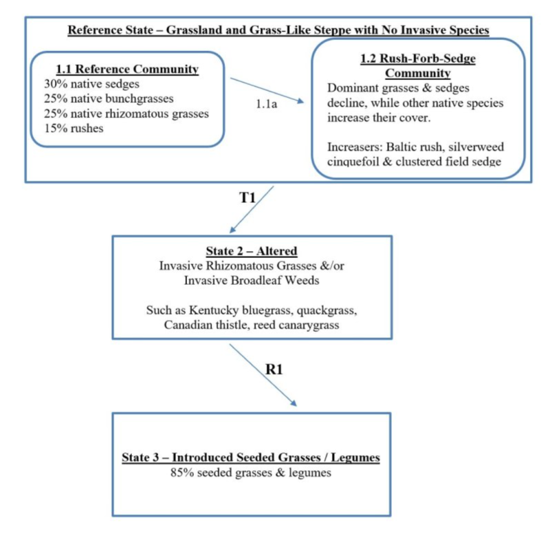
The reference community is largely grass-sedge-rush with a few forbs. Shrubs are virtually nonexistent. Tufted hairgrass, slender wheatgrass, northern reedgrass, bluejoint, clustered field sedge, smallwing sedge and Baltic rush are important grass and grass-like species. Cinquefoil, iris, camas and sagewort are common forbs.
Principle Vegetative Drivers:
The vegetative expression of Wet Meadow is driven by the magnitude and duration of flooding and groundwater discharge. The water table level during mid- and late-season determines the production potential. Wet Meadow is far more productive and any upland site.
Associated Sites:
Wet Meadow is associated with other ecological sites in bottoms and basin areas of MLRA 8, including Loamy Bottom, Alkali Terrace, Sodic Flat, Wetland Complex, and Riparian Complex. Wet Meadow is also associated with upland sites such as Loamy, Stony, and Cool Loamy.
Similar Sites:
There is no similar ecological site at this time.
Associated sites
| R008XY930WA |
Loamy Bottom |
|---|---|
| R008XY970WA |
Alkali Terrace |
| R008XY978WA |
Sodic Flat |
| R008XY720WA |
Riparian Complex |
Table 1. Dominant plant species
| Tree |
Not specified |
|---|---|
| Shrub |
(1) Betula occidentalis |
| Herbaceous |
(1) Deschampsia cespitosa |
Click on box and path labels to scroll to the respective text.