
Natural Resources
Conservation Service
Ecological site R009XY006OR
Cold Clayey Swale 13-17 PZ
Accessed: 04/02/2025
General information
Provisional. A provisional ecological site description has undergone quality control and quality assurance review. It contains a working state and transition model and enough information to identify the ecological site.

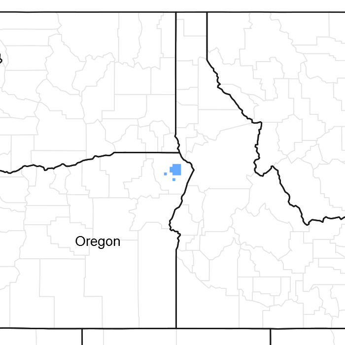
Figure 1. Mapped extent
Areas shown in blue indicate the maximum mapped extent of this ecological site. Other ecological sites likely occur within the highlighted areas. It is also possible for this ecological site to occur outside of highlighted areas if detailed soil survey has not been completed or recently updated.
Associated sites
R009XY005OR |
Cold Swale 13-17 PZ Mountain Swale 13-17 PZ |
---|---|
R009XY017OR |
Cold Loamy 13-17 PZ Mountian Loamy 13-17 PZ |
R009XY022OR |
Cold Shallow 13+ PZ Mountian Shallow 13-17 PZ |
R009XY034OR |
Cold South 13-17 PZ Mountain South 13-17 PZ |
R009XY040OR |
North 14-17 PZ North 13-17 PZ |
Similar sites
R009XY005OR |
Cold Swale 13-17 PZ Mountian Swale 13-17 PZ |
---|
Table 1. Dominant plant species
Tree |
Not specified |
---|---|
Shrub |
Not specified |
Herbaceous |
Not specified |
Physiographic features
This site occurs on upper basalt tablelands adjacent to and on the floodplains of ephemral drainages. It typically occurs at teh upper end of drainages occupying broad to narrow swale areas. Slopes range from 1-15% with slopes of 0 to 3% being most typical. Elevation varies from 3400 to 5000 feet.
Table 2. Representative physiographic features
Landforms |
(1)
Mountain
(2) Swale |
---|---|
Elevation | 1,036 – 1,524 m |
Slope | 0 – 15% |
Aspect | Aspect is not a significant factor |
Climatic features
The annual precipitation ranges from 13 to 17 inches. It occurs as snow during the monthes of November through March followed by ample spring rainfall. Localized, occasionally severe, convection storms occur during the summer. Ephemeral susurface moisture flow augments the precipitation. The mean annual air temperature is aproxiametly 43 degrees F. Extremet temperatures range from 90 degrees F. to -30 degrees F. Soil temperature regimes are frigid. The frost-free period ranges from 30 to 100 days. The period of optimum plant growth is from mid April through July.
Table 3. Representative climatic features
Frost-free period (average) | 100 days |
---|---|
Freeze-free period (average) | 0 days |
Precipitation total (average) | 432 mm |
Figure 2. Monthly average minimum and maximum temperature
Influencing water features
Soil features
The soil of this site are formed in deep aluvium and loess over basalt. They are deep to very deep. Typically the surface layer is a silty clay loam over a clay subsoil. Stoniness is variable. Soil permeability is low. The available water holding capacity (AWC) is 8 to 10 inches. A perched seasonal water table occurs following snow melt. The potential for erosion is moderate.
Table 4. Representative soil features
Surface texture |
(1) Silty clay loam |
---|---|
Family particle size |
(1) Clayey |
Drainage class | Well drained |
Permeability class | Moderate |
Ecological dynamics
Range in Charateristics:
Variabilityin plant composition and yeild is dependent on soil surface texture and drainage area. Idaho fescue increases on heavier textured soils and in areas with limited drainage. Basin wildrye increases on coarser textured surface soils and in areas with extensive drainage systems. Production follows a similar paatern, increasing on swales with large drainage areas that recieve late duration flows.
Response to Disturbance:
If the condiditon of the site deteriorates as a result of overgrazing, Idaho fescue decreases along with basin wildrye. Native bluegrass and forbs increase. Introduced bluegrasses, including Kentucky, Canadian and bulbous bluegrass, invade along with annuals and unplatable forbs continue to increase, annuals strongly invade and useable forage production decreases. Intermittentstreambeds and banks become unstable from loss of vegetation and channels degrade, incising and becoming deeper and wider in the process. Surface flows are affected. Peak discharge increase, seasonal watertables are lowered and erosionfrom concentrated flows reduces the site productivity and contributes to downstream sedimentation.
State and transition model

More interactive model formats are also available.
View Interactive Models
More interactive model formats are also available.
View Interactive Models
Click on state and transition labels to scroll to the respective text
Ecosystem states
State 1 submodel, plant communities
State 1
Historic Climax Plant Community
Community 1.1
Historic Climax Plant Community
The potential native plant community is dominated by Idaho fescue. Bluebunch wheatgrass and basin wildrye are prominant. Prairie junegrass, bluegrass, baltic rush and a variety of forbs are present. The potential vegetative compostion is approximately 95 percent grass and 5 percent forbs.
Figure 3. Annual production by plant type (representative values) or group (midpoint values)
Table 5. Annual production by plant type
Plant type | Low (kg/hectare) |
Representative value (kg/hectare) |
High (kg/hectare) |
---|---|---|---|
Grass/Grasslike | 1184 | 1650 | 2116 |
Forb | 108 | 179 | 251 |
Shrub/Vine | 18 | 36 | 54 |
Total | 1310 | 1865 | 2421 |
Additional community tables
Table 6. Community 1.1 plant community composition
Group | Common name | Symbol | Scientific name | Annual production (kg/hectare) | Foliar cover (%) | |
---|---|---|---|---|---|---|
Grass/Grasslike
|
||||||
1 | Perennial Deep-rooted Dominant | 1184–2116 | ||||
Idaho fescue | FEID | Festuca idahoensis | 897–1255 | – | ||
2 | Perennail Deep-rooted Subdominant | 179–538 | ||||
basin wildrye | LECI4 | Leymus cinereus | 90–269 | – | ||
bluebunch wheatgrass | PSSP6 | Pseudoroegneria spicata | 90–269 | – | ||
4 | Perennail Shallow-rooted Subdominant | 54–143 | ||||
prairie Junegrass | KOMA | Koeleria macrantha | 54–143 | – | ||
5 | PPGG | 54–179 | ||||
western needlegrass | ACOC3 | Achnatherum occidentale | 8–26 | – | ||
sedge | CAREX | Carex | 8–26 | – | ||
California oatgrass | DACA3 | Danthonia californica | 8–26 | – | ||
onespike danthonia | DAUN | Danthonia unispicata | 8–26 | – | ||
squirreltail | ELEL5 | Elymus elymoides | 8–26 | – | ||
bluegrass | POA | Poa | 8–26 | – | ||
Forb
|
||||||
7 | Perennial All Dominant | 72–108 | ||||
arnica | ARNIC | Arnica | 36–54 | – | ||
cinquefoil | POTEN | Potentilla | 36–54 | – | ||
9 | PPFF | 36–143 | ||||
common yarrow | ACMI2 | Achillea millefolium | 3–13 | – | ||
pearly everlasting | ANAPH | Anaphalis | 3–13 | – | ||
milkvetch | ASTRA | Astragalus | 3–13 | – | ||
mariposa lily | CALOC | Calochortus | 3–13 | – | ||
tapertip hawksbeard | CRAC2 | Crepis acuminata | 3–13 | – | ||
old man's whiskers | GETR | Geum triflorum | 3–13 | – | ||
desertparsley | LOMAT | Lomatium | 3–13 | – | ||
lupine | LUPIN | Lupinus | 3–13 | – | ||
owl's-clover | ORTHO | Orthocarpus | 3–13 | – | ||
beardtongue | PENST | Penstemon | 3–13 | – | ||
ragwort | SENEC | Senecio | 3–13 | – | ||
Shrub/Vine
|
||||||
13 | Perennial Decidous Dominant | 18–54 | ||||
rose | ROSA5 | Rosa | 18–54 | – |
Interpretations
Animal community
Livestock grazing:
This site is well suited to late spring, summer and fall use by livestock under a planned grazing system. The key species is Idaho fescue. This site can be damaged if heavily grazed during periods of Idaho fescue flowering and seed formation when root reserves are low. Idaho fescue and basin wildryecan provide excellent standing dry forage during fall dormancy. Grazing system design and implementation should consider the improvement and maintenance of streambed and bank cover during the all seasons. This is particularly important in the fall when enough residue should be left over winter for protection during spring runnof events.
Wildlife:
When the ecological condition is high this site provides excellent forage for deer, elk and various other mammals. It provides excellent nesting areas for a variety of uplanf birds. It is an important wintering area for mule deer and elk.
Native Wildlife Associated With the Potential Climax Community:
Mule deer, whitetail deer, elk, rodents and a variety of upland birds use this site for food and limited cover.
Hydrological functions
The soils of this site have slow intake and permeability rates. Water holding capacities are good, providing late season water for plant growth and water release to streams. The hydrologic cover condition is good when the ecological condition is high. Under a high ecological condition the primary channel is shallow and not well defined. Adequate vegetative cover protects the swale from incision. During the runoff events flows are broad and shallow across vegetative cover which flattens, protecting the soil surface and catching additional sediment.
Other information
In fair condition this site responds rapisly to good mangement. Periodic deferment allows seed production and improvement of Idaho fescue. If incised channels are present, rehabilitation will restore good hydrologic characteristics, including late season water storage, and improved production. On altered sites in poor condition the reintroduction of desirable deep rooted plants may be needed to fully restore the site potential.
Supporting information
Contributors
AV Bahn
Cici Brooks
Justin Gredvig
Rangeland health reference sheet
Interpreting Indicators of Rangeland Health is a qualitative assessment protocol used to determine ecosystem condition based on benchmark characteristics described in the Reference Sheet. A suite of 17 (or more) indicators are typically considered in an assessment. The ecological site(s) representative of an assessment location must be known prior to applying the protocol and must be verified based on soils and climate. Current plant community cannot be used to identify the ecological site.
Author(s)/participant(s) | Jeff Repp |
---|---|
Contact for lead author | Oregon NRCS State Rangeland Management Specialist |
Date | 07/30/2012 |
Approved by | Bob Gillaspy |
Approval date | |
Composition (Indicators 10 and 12) based on | Annual Production |
Indicators
-
Number and extent of rills:
None to some, moderate sheet & rill erosion hazard -
Presence of water flow patterns:
Frequent flooding with seasonal high water table -
Number and height of erosional pedestals or terracettes:
None -
Bare ground from Ecological Site Description or other studies (rock, litter, lichen, moss, plant canopy are not bare ground):
5-10% -
Number of gullies and erosion associated with gullies:
Poor resistance to erosion when cover is lacking - subject to incision and downcutting -
Extent of wind scoured, blowouts and/or depositional areas:
None, slight wind erosion hazard -
Amount of litter movement (describe size and distance expected to travel):
Fine - limited movement -
Soil surface (top few mm) resistance to erosion (stability values are averages - most sites will show a range of values):
Moderately resistant to erosion with adequate cover; aggregate stability = 3-4 -
Soil surface structure and SOM content (include type of structure and A-horizon color and thickness):
Deep alluvium with a silty clay loam surface; moderate OM (2-4$) -
Effect of community phase composition (relative proportion of different functional groups) and spatial distribution on infiltration and runoff:
Significant fround cover (90-100%) and gentle slopes (0-3 - up to 15%) effectively limit rainfall impact and overland flow -
Presence and thickness of compaction layer (usually none; describe soil profile features which may be mistaken for compaction on this site):
None -
Functional/Structural Groups (list in order of descending dominance by above-ground annual-production or live foliar cover using symbols: >>, >, = to indicate much greater than, greater than, and equal to):
Dominant:
Idaho fescue > Basin wildrye = Bluebunch wheatgrass > other perennial grasses > Prairie junegrass > other forbs > cinquefoil > arnica > roseSub-dominant:
Other:
Additional:
-
Amount of plant mortality and decadence (include which functional groups are expected to show mortality or decadence):
Normal decadence and mortlity expected -
Average percent litter cover (%) and depth ( in):
-
Expected annual annual-production (this is TOTAL above-ground annual-production, not just forage annual-production):
Favorable: 2000, Normal: 1600, Unfavorable: 1400 lbs/acre/year at high RSI (HCPC) -
Potential invasive (including noxious) species (native and non-native). List species which BOTH characterize degraded states and have the potential to become a dominant or co-dominant species on the ecological site if their future establishment and growth is not actively controlled by management interventions. Species that become dominant for only one to several years (e.g., short-term response to drought or wildfire) are not invasive plants. Note that unlike other indicators, we are describing what is NOT expected in the reference state for the ecological site:
With deterioration of plant community, bluegrasses invade sites that have lost deep rooted perennial grass functional groups -
Perennial plant reproductive capability:
All species should be capable of reproducing annually
Print Options
Sections
Font
Other
The Ecosystem Dynamics Interpretive Tool is an information system framework developed by the USDA-ARS Jornada Experimental Range, USDA Natural Resources Conservation Service, and New Mexico State University.
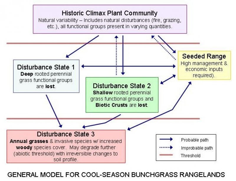
Click on box and path labels to scroll to the respective text.