
Natural Resources
Conservation Service
Ecological site R010XB027OR
JD Clayey 12-16 PZ
Last updated: 3/10/2025
Accessed: 02/07/2026
General information
Approved. An approved ecological site description has undergone quality control and quality assurance review. It contains a working state and transition model, enough information to identify the ecological site, and full documentation for all ecosystem states contained in the state and transition model.
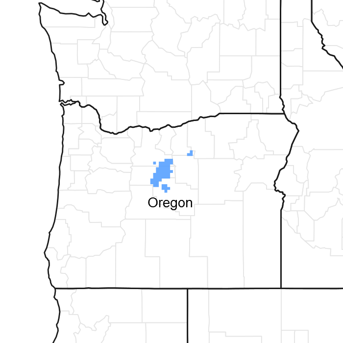
Figure 1. Mapped extent
Areas shown in blue indicate the maximum mapped extent of this ecological site. Other ecological sites likely occur within the highlighted areas. It is also possible for this ecological site to occur outside of highlighted areas if detailed soil survey has not been completed or recently updated.
MLRA notes
Major Land Resource Area (MLRA): 010X–Central Rocky and Blue Mountain Foothills
MLRA 10 in Oregon has 4 sub-divisions; B10XA, B10XB, B10XC & B10XY. B10XA is in the western portion of the MLRA and is designated as the Pumice Zone with ash and pumice (Mazama eruption origin) in the soils and old growth western juniper (Juniperus occidentalis). This ecological site occurs in B10XB which is designated as the John Day/Clarno Zone and is differentiated by its clay soils and invasive western juniper. B10XC is in the south and eastern portion of the MLRA and is designated Upper Snake River Lava Plains and Hills Zone and has predominantly silty clay loam soils over clay, invasive juniper and a greater predominance of shrubs. B10XY denotes ecological sites that occur throughout the MLRA along stream bottoms, riparian areas, meadows, swales and fans.
Classification relationships
This ecological site is most likely within the macro-group M048 Northern Rocky Mountain-Vancouveriann Montane & Foothill Grassland & Shrubland, US National Vegetation Classification (USNVC).
This ecological site is in EPA Ecoregion 11a-John Day/Clarno Uplands.
Ecological site concept
The JD Clayey 12-16 PZ ecological site is a non-aspect site which occurs on flat to rolling topography. Soil temperature regime is primarily mesic and soil moisture regime is xeric (12-16 inches). Soils typical of this ecosite have surface textures that are clay loam to silt loams with an influence of ash and are moderately deep to deep (40-60 inches) and well drained. Gravels, cobbles, and larger rocks are common in most soils that this ecosite occurs on. The reference plant community is dominated by cool season, deep-rooted bunchgrasses that are maintained by low intensity wildfire. Shrubs such as basin big sagebrush and antelope bitterbrush occur in minor amounts in the reference state but can increase in the absence of fire or with disturbance. Western juniper also encroaches on this ecological site and can significantly change the plant composition and production. Invasive, non-native annual grasses can become dominant with prolonged disturbance. The potential for seeding and dryland crop production is high on this ecological site.
Associated sites
| R010XB045OR |
JD Clayey South 12-16 PZ This site has a south aspect. |
|---|---|
| R010XB070OR |
JD North 12-16 PZ This site has a north aspect. |
Similar sites
| R010XB030OR |
JD Loamy 12-16 PZ This site has a loamier subsurface texture, less Idaho fescue, more needlegrasses, and higher production. |
|---|
Table 1. Dominant plant species
| Tree |
Not specified |
|---|---|
| Shrub |
Not specified |
| Herbaceous |
(1) Pseudoroegneria spicata |
Physiographic features
This site occurs on terraces, tablelands (plateaus, structural benches), patterned ground (mounds), low hillslopes, alluvial fans, and rolling uplands. Slopes range from 0 to 20 percent. Elevations range from 2,200 to 4,000 feet.
Table 2. Representative physiographic features
| Landforms |
(1)
Terrace
(2) Plateau (3) Fan remnant |
|---|---|
| Flooding frequency | None |
| Ponding frequency | None |
| Elevation | 2,200 – 4,000 ft |
| Slope | 20% |
| Water table depth | 60 in |
| Aspect | Aspect is not a significant factor |
Climatic features
The annual precipitation ranges from 12 to 16 inches, most of which occurs in the form of snow during the months of November through March. Localized, occasionally severe, convectional storms occur during the summer. The soil temperature regime is mesic with a mean annual air temperature of 50 degrees F. Temperature extremes range from 100 to -10 degrees F. The frost-free period ranges from 108 to 132 days. The optimum period for plant growth is from April through mid-July.
Table 3. Representative climatic features
| Frost-free period (average) | 120 days |
|---|---|
| Freeze-free period (average) | 156 days |
| Precipitation total (average) | 14 in |
Figure 2. Monthly precipitation range
Figure 3. Monthly average minimum and maximum temperature
Figure 4. Annual precipitation pattern
Figure 5. Annual average temperature pattern
Influencing water features
This ecological site is rangeland and is associated with adjacent drainageways and streams. The soils are in hydrologic groups C and D and have moderately high to high runoff potential.
Soil features
The soils of this site are typically moderately deep to deep and well-drained. Typically the surface layer is a stoney clay loam, or cobbly silt loam between 6-10 inches thick with rock fragments ranging from 0-20 percent. The subsoil is a gravelly or cobbly clay loam about 25 inches thick. Depth to bedrock or sediments is 20 to 60 inches. Permeability is very slow to slow. The available water holding capacity is about 2 to 7 inches for the profile. The potential for erosion is moderate to severe. There are soil components correlated to this ecological site have a thinner surface horizon than is typical of the soils of this site, resulting in annual production amounts typical for this site.
Table 4. Representative soil features
| Parent material |
(1)
Colluvium
–
welded tuff
(2) Residuum – basalt (3) Eolian deposits – rhyolite |
|---|---|
| Surface texture |
(1) Stony clay loam (2) Cobbly silt loam (3) Stony loam |
| Family particle size |
(1) Clayey |
| Drainage class | Well drained |
| Permeability class | Very slow to slow |
| Soil depth | 20 – 60 in |
| Surface fragment cover <=3" | 25% |
| Surface fragment cover >3" | 17% |
| Available water capacity (0-40in) |
2 – 7 in |
| Calcium carbonate equivalent (0-40in) |
Not specified |
| Electrical conductivity (0-40in) |
Not specified |
| Sodium adsorption ratio (0-40in) |
Not specified |
| Soil reaction (1:1 water) (0-40in) |
6.1 – 7.3 |
| Subsurface fragment volume <=3" (Depth not specified) |
30% |
| Subsurface fragment volume >3" (Depth not specified) |
40% |
Ecological dynamics
The reference state is considered to be representative of this ecological site under naturally stable, pre-European settlement conditions. Cool season bunchgrasses associated with this site are bluebunch wheatgrass, Idaho fescue and Sandberg bluegrass. Antelope bitterbrush and basin big sagebrush are important shrub species associated with this site. Perennial forbs include lupine, lomatium, milkvetch, buckwheat, and prickly phlox which are found throughout the site and are especially conspicuous during years with above average annual precipitation.
Primary natural disturbances affecting this ecological site are wildfire, herbivory and periodic drought. Timing of disturbance combined with weather events determines plant community dynamics.
• Fire: Woody species are maintained by the frequency of natural wildfires. Historically, when fire regimes were 10-25 years, Western juniper was restricted to protected microsites such as scattered rock outcrops and areas of shallow, rocky soils (ref.: Fire Effects Information System). Low intensity wildfires maintain a grassland community type while the absence of fire increases the fuel load and favors the increase in woody species. Medium and high intensity wildfires increase the recovery time of the plant community and open it to invasion of annual, early seral species.
• Drought: drought related mortality is generally low in this community type. Deep-rooted bunchgrasses, bitterbrush and sagebrush are adapted to receiving limited annual precipitation. Prolonged drought will result in an over-all decline in the grass-forb component of the plant community and reduced annual growth and seedling recruitment of basin big sagebrush.
• Herbivory: herbivory effects on the plant community dynamics will depend on diet preferences of species that utilize the vegetation (browsers vs. grazers), the intensity of defoliation and the ability of the plants to recover from defoliation before being defoliated again. Overuse by grazing species (elk, cattle, horses) will result in a decrease of Idaho fescue and bluebunch wheatgrass while Sandberg bluegrass increases. With continued overgrazing, Sandberg bluegrass decreases in cover, annuals strongly invade, and western juniper, snakeweed, and gray rabbitbrush may increase. Soft chess and medusahead can also typically invade when the seed source is available. Overuse by browsing species (deer, sheep, goats) will influence the plant community to favor the bunchgrasses but will decrease the abundance of forbs and eventually the grass species. Under these deteriorated conditions, bare soil interspaces will increase and excessive erosion can occur, which reduces the site’s vegetative production and can contribute to downstream sedimentation and wind erosion.
State and transition model
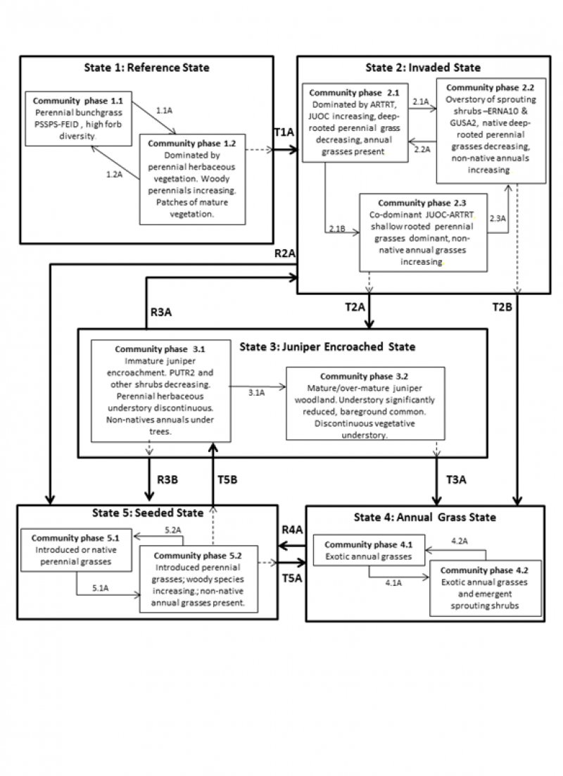
Figure 6. JD Clayey 9-12 PZ state and transition model
More interactive model formats are also available.
View Interactive Models
More interactive model formats are also available.
View Interactive Models
Click on state and transition labels to scroll to the respective text
Ecosystem states
States 2 and 5 (additional transitions)
State 1 submodel, plant communities
State 2 submodel, plant communities
State 3 submodel, plant communities
State 4 submodel, plant communities
State 5 submodel, plant communities
State 1
Reference
This state is dominated by bluebunch wheatgrass with minor amounts of shrubs. Idaho fescue, Sandberg bluegrass and prairie junegrass are other common native grasses. Ecological processes of this state are driven by the perennial grass community. These plants maintain the nutrient cycles, organic matter accumulation, and hydrologic functions in their rooting depth. Energy capture by cool season perennial grasses is limited primarily to spring and early summer. As the deeper rooted woody plants increase, the nutrient cycles, organic matter accumulation, and hydrologic functions are extended deeper into the soil profile. Energy capture is extended through the summer and fall seasons.
Community 1.1
Reference Plant Community-Bunchgrasses & Forbs

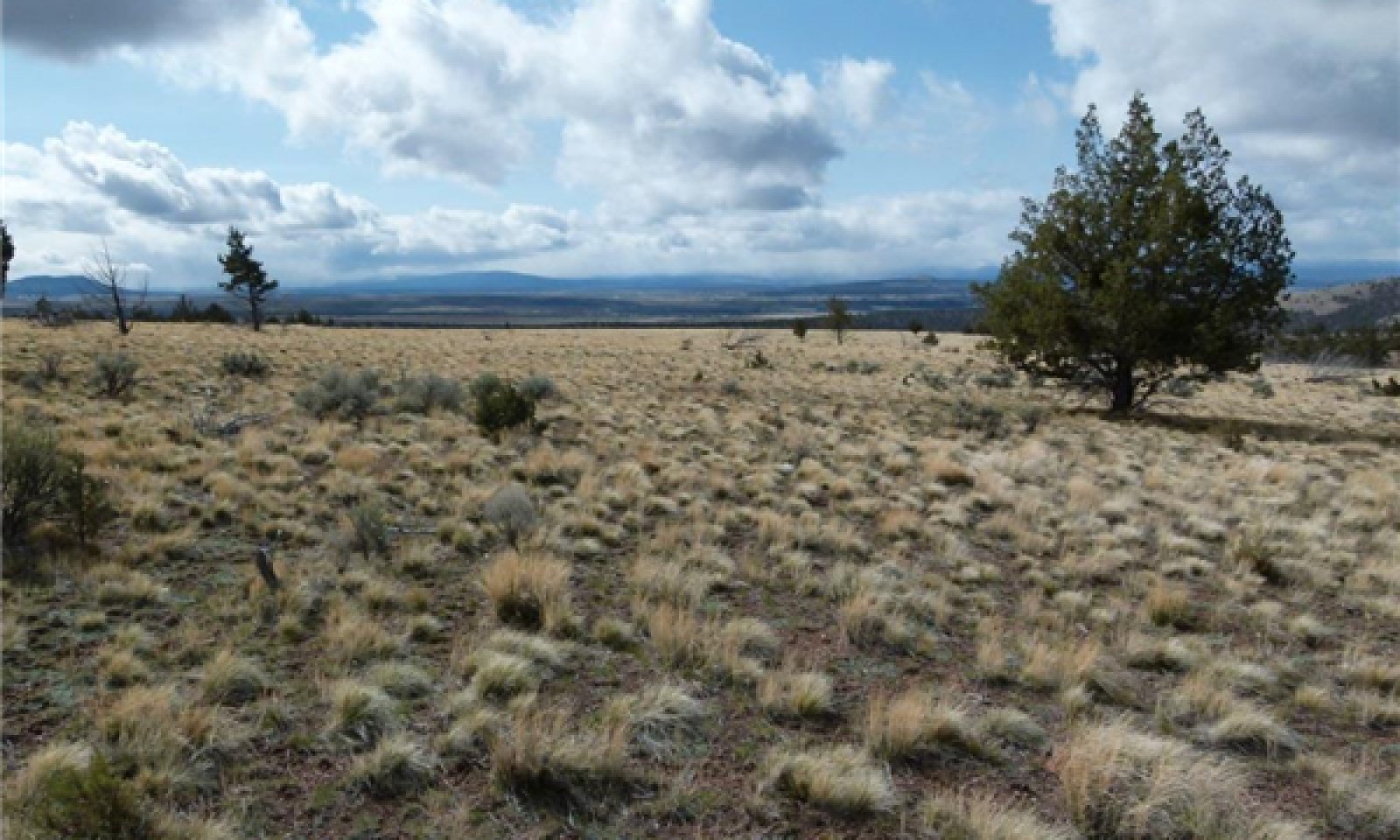
Figure 7. Community phase 1.1-Bunchgrass dominant, Gribble soils series (GrD) 3/21/13 photo by Cici Brooks
This community is characterized by a deep-rooted, perennial bunchgrass grassland with a high diversity of forbs. Dominant species include bluebunch wheatgrass, Idaho fescue, and Sandberg bluegrass. Potential vegetative composition is 80% grasses, 15% forbs, 5% shrubs, and scattered trees in unburned patches. Approximate foliar cover is 45-55%, basal cover is approximately 5-15%. Bare ground is 15 to 20%, and mosses and lichens may make up 1 to 10% of the ground cover as well.
Figure 8. Annual production by plant type (representative values) or group (midpoint values)
Table 5. Annual production by plant type
| Plant type | Low (lb/acre) |
Representative value (lb/acre) |
High (lb/acre) |
|---|---|---|---|
| Grass/Grasslike | 800 | 1000 | 1300 |
| Forb | 40 | 75 | 100 |
| Shrub/Vine | 10 | 20 | 40 |
| Tree | 0 | 5 | 10 |
| Total | 850 | 1100 | 1450 |
Community 1.2
Grass-shrub
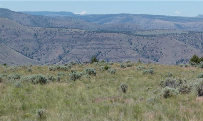
Figure 9. Community Phase 1.2-Grass dominant with shrubs. Prill soil series (162C) 6/28/13 photo by C. Brooks
This plant community is characterized by a bunchgrass-shrub plant community dominated by herbaceous species with increasing woody species. Antelope bitterbrush, rabbitbrush, and horsebrush (Tetradymia spp.) increase post-fire. Basin big sagebrush and western juniper will re-establish from unburned islands following natural, low intensity fires. These fast moving, low intensity fires can result in the incomplete removal of woody species allowing for direct reestablishment and rapid recovery after the fire. More severe fires may remove significantly more sagebrush and juniper from the site and will require a greater amount of time to re-colonize the stand. The rate of re-establishment is based on seed availability within the vicinity of the site. This community is at-risk of invasion by non-native species. Non-native species take advantage of increased availability of critical resources such as moisture or nitrogen following wildfire or other disturbance. Potential vegetative composition is 60-70% grasses, 15% forbs, 15% shrubs and 0 to 5% trees. Approximate foliar cover is 55%, basal cover is 5%. Bare ground is typically 15 to 20%.
Pathway 1.1A
Community 1.1 to 1.2


Control of wildfire, excessive, repeated herbivory and drought will all favor shrub and juniper increase.
Pathway 1.2A
Community 1.2 to 1.1


Fire, insect attack on shrubs, favorable climatic pulses, rest and recovery from defoliation will favor grass dominant phase.
State 2
Invaded
This state of JD Clayey 12-16 PZ ecological site is representative of an invaded state with the introduction of non-native annual grasses as well as the encroachment of native woody species such as western juniper and basin big sagebrush. Bitterbrush, rabbitbrush, horsebrush, and broom snakeweed are other common shrub species. Bluebunch wheatgrass and Idaho fescue are declining in dominance and Sandberg bluegrass is favored but is in competition with exotic non-native annual grasses such as cheatgrass (Bromus tectorum) and medusahead (Taeniatherum caput-medusae). Ecological processes of this state are driven by the shrub community. Soil moisture is improved through the capture of snow in the winter months but nutrient cycling and organic matter is decreased compared to the reference state. The three phases in this state are driven by the presence or absence of fire as well as drought and/or repeated, excessive herbivory.
Community 2.1
Sagebrush-grass
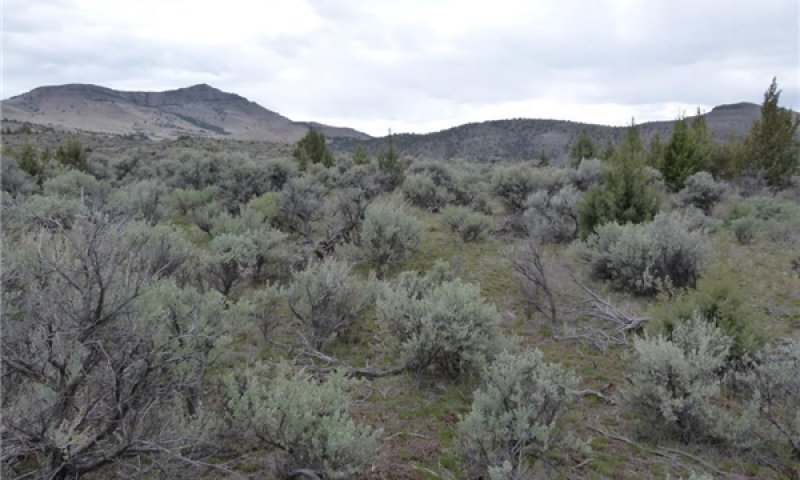
Figure 10. Community phase 2.1-bunchgrass-shrubs, Prill soil series (161C) 3/29/13 photo by Cici Brooks
This community is characterized by a mid seral plant community dominated by the encroachment of woody species. It is the dominant phase following the introduction of annuals and the suppression of natural fire. Basin big sagebrush favors the deep soils and dry climate of this site; juniper encroachment is increasing while perennial deep-rooted grasses are declining. Potential vegetative composition by weight is 60% grasses, 20% forbs, 10-15% shrubs and up to 5-10% trees. Foliar cover is 76%, basal cover is approximately 35% and ground cover is 92%.
Community 2.2
Sprouting shrubs
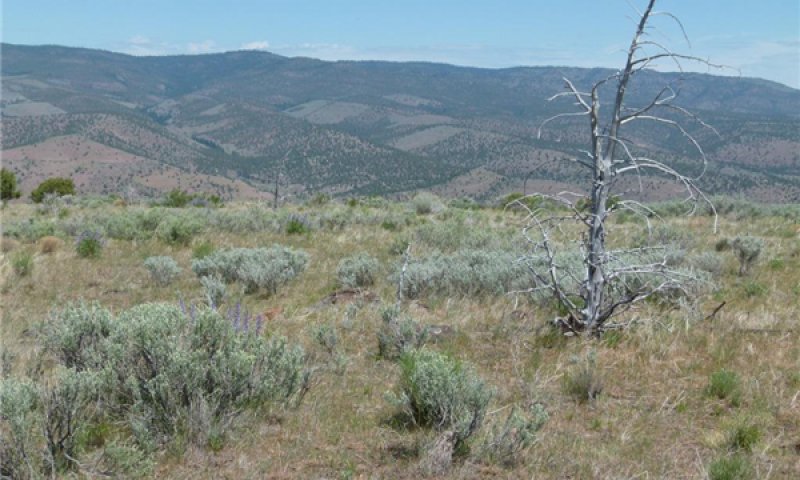
Figure 11. Community phase 2.2-Sprouting shrubs-grass, Prill soil series (162C) 5/15/13 photo by Cici Brooks
This community is characterized by early seral sprouting shrubs following fire. Native, deep-rooted perennial grass species are sparse. Shallow-rooted perennial grasses and non-native annual grasses are favored by fire and increase in dominance. This community phase is the "at-risk" phase of this state which means this state has the potential to cross a threshold into a non-native annual grass dominated state through an intense, stand-replacing fire or continued heavy herbivory. Potential vegetative composition by weight is 65% grasses, 10% forbs, 24% shrubs and up to 1% trees. Approximate foliar cover is 45-55 %, basal cover is 15-20% and bare ground is 15%.
Community 2.3
Sage-juniper
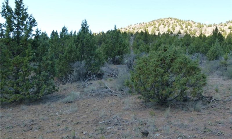
Figure 12. Community phase 2.3-juniper dominant, Tub soil series (TvD) 6/14/13 photo by Cici Brooks
This community is characterized by a mid-seral plant community with western juniper (early juniper successional phase II-ref. Miller, R.F. 2005) becoming co-dominant with basin big sagebrush. Bitterbrush, rabbitbrush and broom snakeweed are common. This phase is the "at-risk" phase to cross a threshold into a tree dominated state (state 3). Indicators that the plant community is approaching the threshold include an increase in juniper dominance and a decrease in perennial deep rooted grass species with an increase in bare ground. Potential vegetative composition by weight is 55% grasses, 5% forbs, 20% shrubs and up to 20% trees. Approximate ground cover (basal and foliar) is 40 to 70%.
Pathway 2.1A
Community 2.1 to 2.2


Fire, repeated excessive herbivory will favor sprouting shrubs.
Pathway 2.1B
Community 2.1 to 2.3


Lack of low intensity fires will allow increasing encroachment of western juniper.
Pathway 2.2A
Community 2.2 to 2.1


Time since fire (and control of fire) and managed grazing will benefit recruitment of sagebrush, juniper, and deep rooted perennial grasses. Length of time for sagebrush communities to fully recover is dependent on ecological variables such as spring time precipitation and/or proximity of nearest seed source.
Pathway 2.3A
Community 2.3 to 2.2


Medium intensity fire will decrease sagebrush and juniper species and favor sprouting shrubs.
State 3
Juniper Encroached
This State is a tree dominated state with woodland successional phase II and III of western juniper present. Shrub communities dominated by basin big sagebrush and bitterbrush have declined and remnant shrubs that are still present in this state include rabbitbrush, horsebrush, and broom snakeweed. Bluebunch wheatgrass and Idaho fescue cover declines and they are diminished to occupying the more moist (shaded) microsites. Sandberg bluegrass is the primary dominant grass that remains but it is in competition with non-native annual grasses such as cheatgrass and medusahead. Ecological processes in this state are driven by western juniper. Juniper is highly competitive for moisture capture having a taproot that averages 51 inches (130 cm) in depth and root-to-shoot ratios that decrease with age. Interception of rainfall by its dense canopy is another adaptation to its moisture competitiveness which allows it to out-compete species such as basin big sagebrush. Nutrients are captured for longer periods in above ground biomass and organic matter decreases as bare ground increases. Historically, when fire regimes were 10-25 years, juniper was restricted to protected microsites such as scattered rock outcrops and areas of shallow, rocky soils (ref.: Fire Effects Information System.) There are two plant communities in this state separated by their ability to carry a fire, the type of fire and the frequency of burn events.
Community 3.1
Immature juniper dominant plant community
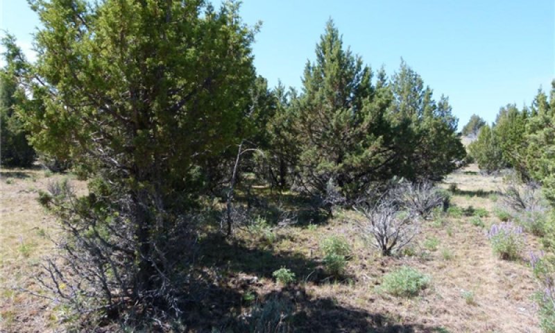
Figure 13. Community phase 3.1-immature juniper dominant Prill soil series (162C) 5/15/13 photo by Cici Brooks
This community phase is characterized by a multi-aged stand of immature juniper trees (late JUOC phase II.) The trees are controlling the moisture and nutrient cycles of the site. Interception of rainfall and water uptake by the trees has altered the ability of other functional groups on the site to survive. Bitterbrush, if present will be decreasing and basin big sagebrush is dying. Shallow-rooted perennial grasses are dominant in the understory and annual grasses are common. Bare ground has increased and some soil erosion is occurring. This plant community phase no longer has the ability to carry a fire due to the interspaces in the fuels. Potential vegetative composition by weight is 50% grasses, 5% forbs, 10% shrubs and up to 35% trees. Approximate foliar cover is 45 to 60% and basal cover is approximately 20%.
Community 3.2
Mature juniper woodland
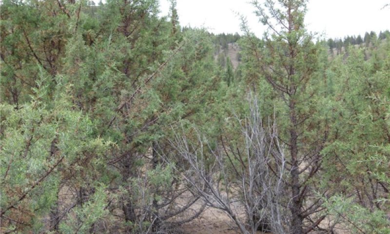
Figure 14. Community phase 3.2-small diameter woodland Belshaw soil series (191C) 6/18/13 photo by Cici Brooks
This community phase is characterized by a mature juniper woodland (JUOC phase III) with shrubs severely limited or no longer present in the understory. Sandberg bluegrass and annual grasses are the remaining grass species with bare ground increasing and sheet & rill erosion occurring. The ability of this community phase to carry a fire is limited to following mechanical juniper control or following climatic conditions that would favor a high intensity wildfire (crown fire) which will immediately cause the site to cross a threshold into an early seral annual grass state (State 4). Potential vegetative composition by weight is 25% grasses, 5% forbs, 15% shrubs and up to 55% trees. Approximate ground cover (basal and foliar) is 10 to 15%.
Pathway 3.1A
Community 3.1 to 3.2


Time without fire will favor the increase of western juniper, decrease ground cover and ladder fuels, and further reduce the ability of the site to burn.
State 4
Annual
This state is characterized by the dominance of non-native annual grasses. These grasses drastically change the natural fire cycles as well as the moisture and nutrient status of the soil. Cheatgrass, soft chess (Bromus mollis) and medusahead germinate in the fall and establish root systems that are able to elongate through the dormant season and capture early soil moisture which creates adverse growing conditions and effectively dries out the site for more desirable species. Medusahead is better adapted to clay surfaces and creates a thick thatch that lays flat on the soil surface and sheds any moisture to limit the ability of other competing species to survive. Annual grasses complete their growth by early summer and become prone to wildfires during the driest time of the year. They produce a continuous, fine fuel source that favors hot, quick moving fires. These flash fires create an ash, nitrogen-rich duff that harbors the profuse seed bank that the annuals produce in order to monopolize the next flush of precipitation. Soil organic matter decreases due to the loss of root mass produced by the deep-rooted perennials which are replaced by these shallow-rooted annual grasses. The invasion of annual grasses changes the historic fire frequency and results in the loss of shrubs such as sagebrush and other non-sprouting woody species.
Community 4.1
Non-native grasses
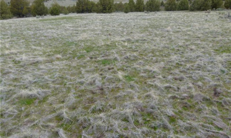
Figure 15. Community phase 4.1-Annual grass dominant, Sweek soil series (175C) 3/29/13 photo by Cici Brooks
Non-native annual grasses in this community phase include annual brome grass species, medusahead, and ventenata. Ground cover is continuous, bare ground is decreased, and plant productivity becomes dependent on annual precipitation cycles. Annual grasses provide fall, winter, and spring forage for many wildlife and livestock species but are not suitable for summer grazing use and productivity fluctuates with the amount of precipitation. Shallow-rooted annual grasses are not able to access deeper moisture and complete their growing cycle when surface soil moisture is depleted. Potential vegetative composition by weight is 80% grasses, 20% annual forbs. Approximate ground cover (basal and foliar) is 50 to 90%.
Community 4.2
Annual grass and fire tolerent shrubs
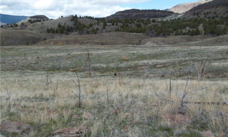
Figure 16. Community phase 4.2-Annual grass, fire tolerent shrubs, Sweek soil (175C) 3/29/13 photo by C. Brooks
This community phase may occur where sprouting shrubs are still a part of the plant community either through patchy, unburned areas and/or disturbance. Potential vegetative composition by weight is 85% grasses, 5% forbs, 10% shrubs. Approximate ground cover (basal and foliar) is 90 to 95%.
Pathway 4.1A
Community 4.1 to 4.2


Active wildfire suppression, control of annual grasses favors the increase of sprouting shrubs.
Pathway 4.2A
Community 4.2 to 4.1


Continuation of frequent fires can eventually eliminate sprouting shrubs and favors annual grasses.
State 5
Seeded
Seeding of this ecological site is common due to the favorable soil characteristics, a favorable moisture regime, and no slope limitations. Seeding alternatives will vary based on the state and community phase this site is in at the time of seeding.
Community 5.1
Adapted seeded grass species
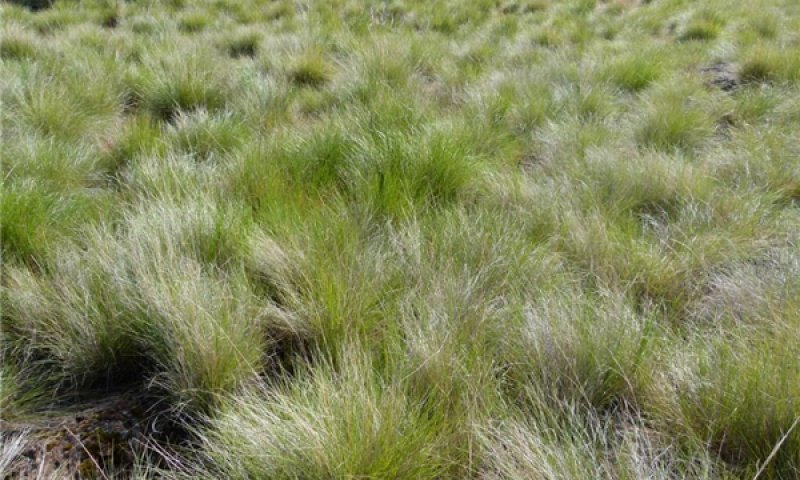
Figure 17. Community phase 5.1-Native seeding, Belshaw soil series (191C) 5/23/13 photo by Cici Brooks
This community phase is characterized by adapted introduced and/or native species of grasses. Potential vegetative composition by weight is 90-95% grasses, 5% forbs. Shrubs and trees may invade with time. Approximate ground cover (basal and foliar) is 90 to 100%.
Community 5.2
Seeded grass-encroached woody species
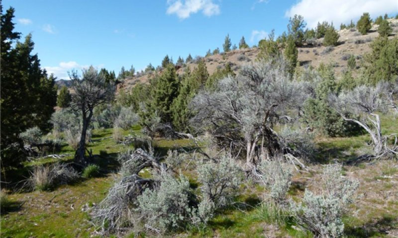
Figure 18. Community phase 5.2-seeded, encroached Prill soil series (162C) 4/10/13 photo by Cici Brooks
This community phase is experiencing the invasion of woody species that occurs along the perimeter of the mechanically manipulated seeded areas. Annual grasses may re-invade with excessive herbivory and disturbance. The potential vegetative composition by weight is 80% grasses, 10% forbs, 9% shrubs and up to 1% trees.
Pathway 5.1A
Community 5.1 to 5.2


Exclusion of fire and continued, heavy herbivory will favor increase of woody species.
Pathway 5.2A
Community 5.2 to 5.1


Fire or mechanical removal of shrubs and prescribed grazing will favor the grass phase.
Transition T1A
State 1 to 2
State 1 becomes vulnerable to invasion through prolonged disturbance and altered natural fire regimes. Disturbance can be from control of wildfire, prolonged and repeated herbivory or farming practices. Plant community phase 1.2 is "at risk" to cross into state 2 due to the continued increase of woody species and the introduction of non-native annual grasses. The encroachment and invasion results in a reduction in production and recruitment of deep-rooted perennial grasses and an increase in bareground. Surface soil compaction increases which reduces water infiltration and favors shallow rooted grasses and deeper-rooted shrubs.
Transition T2A
State 2 to 3
Community phase 2.3 may cross a threshold into State 3 due to lack of fire and prolonged, repeated herbivory. Bare ground has increased and soil loss is occurring, increasing the space between herbaceous species that diminish the amount of fine fuels available to carry a fire. Shrubs in the understory are widely spaced and deep-rooted perennial grasses are becoming confined to beneath the tree and remaining shrub canopies. Shallow-rooted perennial grasses are the dominant understory species and non-native annual grasses are common.
Transition T2B
State 2 to 4
Community phase 2.2 may cross a threshold to State 4 if intense or recurring fires and excessive repeated herbivory occurs. Mechanical seedbed preparation without adequate seedling establishment can also take this community phase over a threshold to a non-native annual grass state.
Restoration pathway R2A
State 2 to 5
Any community phase in State 2 can be converted through mechanical seedbed preparation and planting to adapted deep-rooted perennial forage species. This ecological site is also prone to being farmed for dryland or irrigated crops due to the deep soils and the xeric moisture regime.
Restoration pathway R3A
State 3 to 2
Mechanical brush control of juniper without treatment of other woody species will restore phase 3.1 to a community phase in state 2; the new community phase in state 2 will depend on the existence of relict deep-rooted perennial grass and shrubs species.
Transition T3A
State 3 to 4
Mechanical control and burning of juniper in this state without the re-introduction of adapted perennial deep-rooted grass species will favor the increase of annual grasses which will change the fire regime and drive either community phase to state 4.
Restoration pathway R3B
State 3 to 5
Mechanical control and burning or removal of juniper combined with seedbed preparation and seeding of adapted species will restore deep-rooted periennial grasses and change ecological process to drive either community phase to state 5.
Restoration pathway R4A
State 4 to 5
Herbicide, mechanical seedbed preparation, and successful establishment of seeded desirable grasses & forbs will restore ecological processes and functions to favor either community phase to cross a threshold into State 5.
Transition T5B
State 5 to 3
Encroachment of juniper and the loss of desirable seeded species through heavy and repeated herbivory would result in the transition to community phase 3.1.
Transition T5A
State 5 to 4
Excessive disturbance by herbivory and fire will favor the increase of annual grasses.
Additional community tables
Table 6. Community 1.1 plant community composition
| Group | Common name | Symbol | Scientific name | Annual production (lb/acre) | Foliar cover (%) | |
|---|---|---|---|---|---|---|
|
Grass/Grasslike
|
||||||
| 1 | Perennial, deep-rooted, dominant | 720–1200 | ||||
| bluebunch wheatgrass | PSSP6 | Pseudoroegneria spicata | 480–720 | – | ||
| Idaho fescue | FEID | Festuca idahoensis | 240–480 | – | ||
| 2 | Perennial, deep-rooted, sub-dominant | 20–70 | ||||
| Thurber's needlegrass | ACTH7 | Achnatherum thurberianum | 12–36 | – | ||
| prairie Junegrass | KOMA | Koeleria macrantha | 12–36 | – | ||
| 3 | Shallow rooted, perennial | 12–36 | ||||
| Sandberg bluegrass | POSE | Poa secunda | 12–36 | – | ||
| 4 | Other perennial grasses | 12–24 | ||||
| California brome | BRCA5 | Bromus carinatus | 0–8 | – | ||
| squirreltail | ELEL5 | Elymus elymoides | 0–8 | – | ||
| basin wildrye | LECI4 | Leymus cinereus | 0–8 | – | ||
|
Forb
|
||||||
| 5 | Perennial, dominant | 35–70 | ||||
| common yarrow | ACMI2 | Achillea millefolium | 12–24 | – | ||
| milkvetch | ASTRA | Astragalus | 12–24 | – | ||
| lupine | LUPIN | Lupinus | 12–24 | – | ||
| 6 | Other forbs | 12–36 | ||||
| agoseris | AGOSE | Agoseris | 0–3 | – | ||
| onion | ALLIU | Allium | 0–3 | – | ||
| pussytoes | ANTEN | Antennaria | 0–3 | – | ||
| arrowleaf balsamroot | BASA3 | Balsamorhiza sagittata | 0–3 | – | ||
| mariposa lily | CALOC | Calochortus | 0–3 | – | ||
| tapertip hawksbeard | CRAC2 | Crepis acuminata | 0–3 | – | ||
| fleabane | ERIGE2 | Erigeron | 0–3 | – | ||
| buckwheat | ERIOG | Eriogonum | 0–3 | – | ||
| blanketflower | GAILL | Gaillardia | 0–3 | – | ||
| stoneseed | LITHO3 | Lithospermum | 0–3 | – | ||
| desertparsley | LOMAT | Lomatium | 0–3 | – | ||
| phlox | PHLOX | Phlox | 0–3 | – | ||
|
Shrub/Vine
|
||||||
| 7 | Other perennial shrubs | 5–36 | ||||
| basin big sagebrush | ARTRT | Artemisia tridentata ssp. tridentata | 0–5 | – | ||
| yellow rabbitbrush | CHVI8 | Chrysothamnus viscidiflorus | 0–5 | – | ||
| rubber rabbitbrush | ERNA10 | Ericameria nauseosa | 0–5 | – | ||
| antelope bitterbrush | PUTR2 | Purshia tridentata | 0–5 | – | ||
| rose | ROSA5 | Rosa | 0–5 | – | ||
| spineless horsebrush | TECA2 | Tetradymia canescens | 0–5 | – | ||
| broom snakeweed | GUSA2 | Gutierrezia sarothrae | 0–5 | – | ||
|
Tree
|
||||||
| 8 | Evergreen trees | 0–1 | ||||
| western juniper | JUOC | Juniperus occidentalis | 0–1 | – | ||
Interpretations
Animal community
Livestock Grazing:
This site is suited to use by cattle, horses, and sheep in the spring, summer, and fall under a planned grazing system. Maintaining sufficient ground cover and litter aids in the infiltration of rainfall, decreases runoff, and builds soil organic matter. Livestock use should be postponed until the soils are firm enough to avoid trampling damage and soil compaction. Forage production for grazers is greatest in State 1 and State 5 but state 4 can provide seasonal forage depending on the annual moisture conditions. State 2 can provide the greatest forage value for browser types of livestock such as sheep and goats.
Native Wildlife :
A single ecosite rarely provides the only habitat for any one species of wildlife. It is important to consider how the vegetation communities of multiple ecosites interact across the landscape and how they collectively are able to satisfy the habitat needs for the wildlife species that are being evaluated. A general interpretation for this ecological site follows for the common wildlife species that may occur on this site and how the plant communities (States) may impact their habitat needs. Conservation and/or Management practices (NRCS practice code in parentheses) that benefit each state are highlighted but will need refinement based on the complex of associated ecological sites and the landowner’s management objectives. The need for any of the conservation practices mentioned will depend on the management objectives and site specific conditions. Additional or more detailed recommendations are available at local NRCS field offices.
In the reference state, the JD Clayey 12 – 16 Ecological Site provides habitat for over 100 species of birds and over 70 species of mammals. Animal species indicative of the grassland community phase which is dominated by bluebunch wheatgrass and Idaho fescue include bird species like the grasshopper sparrow, lark sparrow and the vesper sparrow and important commercial mammal species like elk, mule deer, and pronghorn antelope. As the composition of sagebrush increases, the site provides habitat for mule deer, sage thrasher, sage sparrow, pygmy rabbit and the black-throated sparrow. The clay soils retain winter moisture and can provide a flush of spring forbs which supply important nutrition for mule deer and pollinators. Conservation practices that benefit wildlife in this state include Prescribed Grazing (528), Fencing (382), Brush Management (314), Watering Facility (614) Spring Development (574), Prescribed Burning (378), Herbaceous Weed Control (315) & Upland Wildlife Habitat Management (645).
State 2 - As brush thickens and juniper begins to occupy the site, grassland wildlife decreases. Decreases in hiding cover (screening) provided by large bunch grasses results in increased vulnerability to predators for ground nesting birds. The avifuana shifts to generalist species such as the northern mocking bird and species that favor more brush like the green-tailed towhee and black-throated sparrow. Forb production and diversity are diminished reducing the site’s value to pollinators. Conservation practices that benefit wildlife in this state include Prescribed Grazing (528), Fencing (382), Brush Management (314), Watering Facility (614) Spring Development (574), Prescribed Burning (378), Herbaceous Weed Control (315) & Upland Wildlife Habitat Management (645).
State 3 - In the mature juniper phase the generalist species will be replace by juniper woodland specialists. Ash-throated flycatcher, black-chinned hummingbird and the gray flycatcher will use this habitat. Mule deer could use these woodlands for escape and thermal cover. Conservation practices are similar to those used in state 2 but will be more costly to implement; Prescribed Grazing (528), Fencing (382), Brush Management (314), Watering Facility (614) Spring Development (574), Prescribed Burning (378), Herbaceous Weed Control (315) & Upland Wildlife Habitat Management (645).
State 4, the annual grass state has very limited wildlife value. Where annual forbs are present, it provides limited habitat in the fall through spring period to mule deer where hiding cover is present within close vicinity. Early green growth of annual grasses provides nutritious forage for grazing species but is not a dependable source of forage because production fluctuates widely with annual growing conditions. Conservation practices that benefit wildlife in this state include Range Planting (550; crosses threshold to state 5), Access Control (472), Early Successional Habitat Development/Management (647), Prescribed Grazing (528), Fencing (382), Watering Facility (614), Spring Development (574), Prescribed Burning (378), Firebreak (394) and Herbaceous Weed Control (315).
State 5 - the seeded state can be a valuable source of forage for grazers such as elk. This state can provide suitable plant dynamics (nutrient cycling, energy capture, moisture capture) to aid in the establishment of sagebrush and other native shrubs. The value of the seeded state for wildlife habitat depends largely on post seeding plant succession. As the structure and diversity increases the site provides habitat for a greater number of species. Prescribed Grazing (528), Fencing (382), Brush Management (314), Watering Facility (614) Spring Development (574), Prescribed Burning (378), Herbaceous Weed Control (315) & Upland Wildlife Habitat Management (645).
Hydrological functions
The soils are in hydrologic groups C and D. The soils of this site have moderately high to high runoff potential.
Recreational uses
Camping, hiking, biking, horseback riding, bird and wildlife watching and hunting are suitable recreational uses of this ecological site.
Wood products
This site is susceptible to increase in western juniper. Where this has occured, the site will yield fence posts, firewood, and specialty products.
Other information
Increase in western juniper and the subsequent competition for moisture will lead to a reduction of available forage. Overgrazing can easily reduce ground cover and accelerate soil loss. Improving infiltration and permeability, and reducing runoff should be the immediate goal of juniper or brush control. This site has potential for seeding as needed following juniper and/or brush control.
Supporting information
Type locality
| Location 1: Jefferson County, OR | |
|---|---|
| Township/Range/Section | T11S R14E S23 |
| UTM zone | N |
| UTM northing | 4940064.13 |
| UTM easting | 657468.47 |
| Latitude | 121° 0′ 57″ |
| Longitude | 44° 35′ 48″ |
| General legal description | Crooked River National Grasslands |
Other references
Tirmenstein, D. 1999. Artemisia tridentata spp. tridentata. In: Fire Effects Information System, [Online]. U.S. Department of Agriculture, Forest Service, Rocky Mountain Research Station, Fire Sciences Laboratory (Producer). Available: http://www.fs.fed.us/database/feis/ [2013, September 10].
*Miller, R. F., J. C. Chambers, D. A. Pyke, F. B. Pierson, and C. J. Williams. In press. Fire effects on vegetation and soils in the Great Basin region: response and site characteristics. USDA Forest Service, Fort Collins, Colorado, USA.
Contributors
A. Bahn, J. Thompson, B. O'Donnell, H. Barrett
A. Bahn, J. Thompson, B. O'Donnell, H. Barrett
Cici Brooks
M. Parks (OSU)
Approval
Kirt Walstad, 3/10/2025
Rangeland health reference sheet
Interpreting Indicators of Rangeland Health is a qualitative assessment protocol used to determine ecosystem condition based on benchmark characteristics described in the Reference Sheet. A suite of 17 (or more) indicators are typically considered in an assessment. The ecological site(s) representative of an assessment location must be known prior to applying the protocol and must be verified based on soils and climate. Current plant community cannot be used to identify the ecological site.
| Author(s)/participant(s) |
Jeff Repp and Bruce Frannsen Lars Santana |
|---|---|
| Contact for lead author | State Rangeland Management Specialist for NRCS - Oregon |
| Date | 11/29/2018 |
| Approved by | Bob Gillaspy |
| Approval date | |
| Composition (Indicators 10 and 12) based on | Annual Production |
Indicators
-
Number and extent of rills:
Typically there are no rills on this site. -
Presence of water flow patterns:
Water flow patterns rarely occur on this site. If they occur, they are rare, narrow, short, and disconnected, disrupted by cool season perennial grasses and shrubs and are not extensive. -
Number and height of erosional pedestals or terracettes:
Pedestals and/or terracettes are not expected to occur on this site. Pedestals may occur on steeper slopes, but they are rare. -
Bare ground from Ecological Site Description or other studies (rock, litter, lichen, moss, plant canopy are not bare ground):
Bare ground ranges from 15 - 20%. Bare ground should be small and scattered across the site. -
Number of gullies and erosion associated with gullies:
Gullies do not occur on this site. -
Extent of wind scoured, blowouts and/or depositional areas:
Wind scoured, blowouts, and/or depositional areas are rare. Infrequent occasions slight depositional areas might be noticed under shrubs, but this is within the natural range of variability. -
Amount of litter movement (describe size and distance expected to travel):
Fine litter in the interspaces may move up to 12 inches following a significant run-off event. Coarse litter generally does not move. -
Soil surface (top few mm) resistance to erosion (stability values are averages - most sites will show a range of values):
Interspace: 4 or greater Plant Canopy: 5 or greater
‘Soil Stability Test’ stability class ratings should be 4 or greater in the interspaces, and 5 or greater under canopy. -
Soil surface structure and SOM content (include type of structure and A-horizon color and thickness):
Surface horizon(s) should be 6-10” (roots growing throughout) with a moderate very fine granular structure. -
Effect of community phase composition (relative proportion of different functional groups) and spatial distribution on infiltration and runoff:
Deep rooted perennial bunchgrasses and shrubs are distributed evenly to provide moderate ground cover to catch snow, slow runoff, and increase infiltration.
Relative composition is 80% grass, 15% forbs, 5% shrubs and trees. -
Presence and thickness of compaction layer (usually none; describe soil profile features which may be mistaken for compaction on this site):
No compaction layers are present on this site. -
Functional/Structural Groups (list in order of descending dominance by above-ground annual-production or live foliar cover using symbols: >>, >, = to indicate much greater than, greater than, and equal to):
Dominant:
Perennial deep-rooted bunchgrasses: (3 species min)Sub-dominant:
Perennial Shallow-rooted bunchgrasses: (1 species min)
Perennial Forbs: (5 species min)Other:
Minor F/S Group: Shrubs: (2 species min)
Trace F/S Group: Trees: (1 species min) JuniperAdditional:
12a. Relative Dominance:
Community 1.1 = Perennial deep-rooted bunchgrasses Perennial Shallow-rooted bunchgrasses Perennial Forbs Shrubs
Community 1.2 = Perennial deep-rooted bunchgrasses Perennial Shallow-rooted bunchgrasses Perennial Forbs = Shrubs Trees
12b. F/S Groups not expected for the site: Annual Grass
12c. Number of F/S Groups: 5 groups
12d. Species number in Dominant and Sub-dominant F/S Groups: 9 species -
Amount of plant mortality and decadence (include which functional groups are expected to show mortality or decadence):
A few (less than 3%) dead centers may occur in bunchgrasses. Shrubs may show some dead branches as plants age. -
Average percent litter cover (%) and depth ( in):
Plant litter cover is expected to be 10-15% and at a depth of 0.5 inches under shrubs and 0.1 inches under grass canopy. Exotic annual grass excessive litter can negatively impact the functionality of this site. -
Expected annual annual-production (this is TOTAL above-ground annual-production, not just forage annual-production):
Low: 850 lbs/ac, Normal: 1,100 lbs/ac, High 1,450 lbs/ac
Annual production is 1,100 pounds per acre in a year with normal precipitation and temperatures. Low and High production years should yield 850 and 1,100 pounds per acre respectively. -
Potential invasive (including noxious) species (native and non-native). List species which BOTH characterize degraded states and have the potential to become a dominant or co-dominant species on the ecological site if their future establishment and growth is not actively controlled by management interventions. Species that become dominant for only one to several years (e.g., short-term response to drought or wildfire) are not invasive plants. Note that unlike other indicators, we are describing what is NOT expected in the reference state for the ecological site:
Exotic annual grasses and other exotic forbs/weeds can readily invade this site. Juniper can increase and degrade this site. -
Perennial plant reproductive capability:
All species should be capable of reproducing annually.
Print Options
Sections
Font
Other
The Ecosystem Dynamics Interpretive Tool is an information system framework developed by the USDA-ARS Jornada Experimental Range, USDA Natural Resources Conservation Service, and New Mexico State University.
Click on box and path labels to scroll to the respective text.