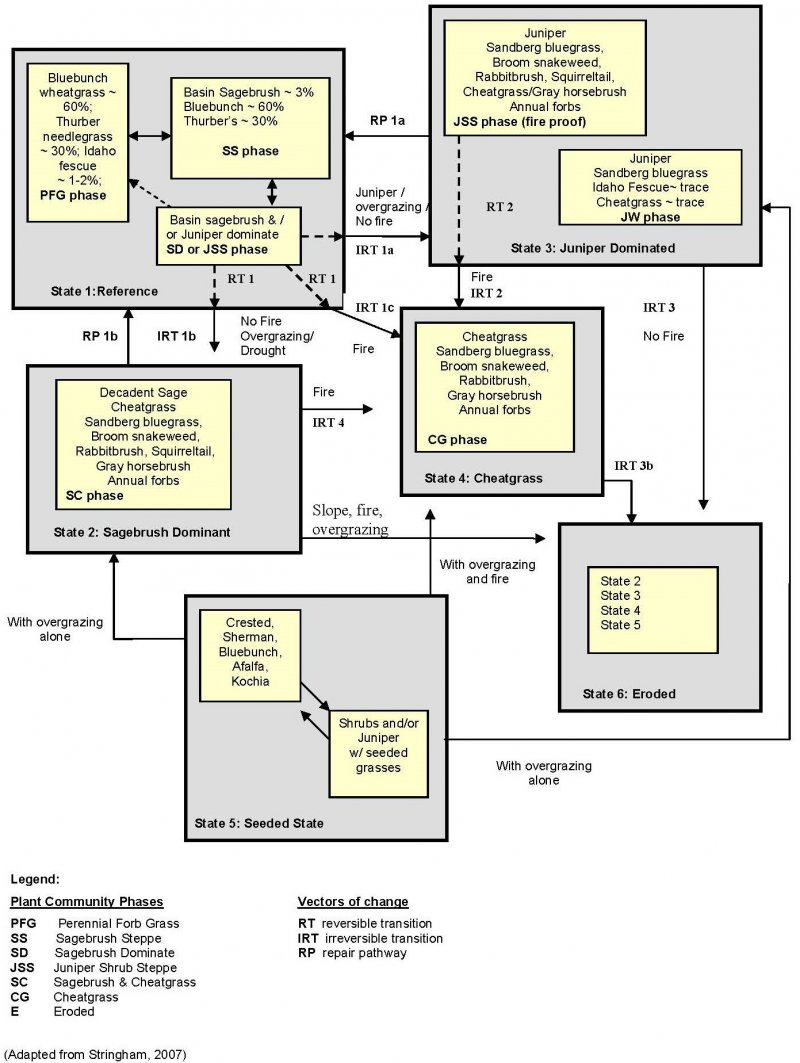
Provisional. A provisional ecological site description has undergone quality control and quality assurance review. It contains a working state and transition model and enough information to identify the ecological site.
MLRA notes
Major Land Resource Area (MLRA): 010X–Central Rocky and Blue Mountain Foothills
This MLRA is characterized by gently rolling to steep hills, plateaus, and low mountains at the foothills of the Blue Mountains in Oregon and the Central Rocky Mountains in Idaho. The geology of this area is highly varied and ranges from Holocene volcanics to Cretaceous sedimentary rocks. Mollisols are the dominant soil order and the soil climate is typified by mesic or frigid soil temperature regimes, and xeric or aridic soil moisture regimes. Elevation ranges from 1,300 to 6,600 feet (395 to 2,010 meters), increasing from west to east. The climate is characterized by dry summers and snow dominated winters with precipitation averaging 8 to 16 inches (205 to 405 millimeters) and increasing from west to east. These factors support plant communities with shrub-grass associations with considerable acreage of sagebrush grassland. Big sagebrush, bluebunch wheatgrass, and Idaho fescue are the dominant species. Stiff sagebrush, low sagebrush, and Sandberg bluegrass are often dominant on sites with shallow restrictive layers. Western juniper is one of the few common tree species and since European settlement has greatly expanded its extent in Oregon. Nearly half of the MLRA is federally owned and managed by the Bureau of Land Management. Most of the area is used for livestock grazing with areas accessible by irrigation often used for irrigated agriculture.
Ecological site concept
In reference condition, this ecological site supports a plant community dominated by bluebunch wheatgrass (Pseudoroegneria spicata). Thurber’s needlegrass (Achnatherum thurberianum) is also common. Abiotically, this site is characterized by moderately deep to deep clayey soils with significant cobbles and stones present. This site receives low precipitation and generally occupies droughty, southerly aspects, lowering plant community resilience to disturbance. The soil climate is Mesic/Aridic. Historically, plant community dynamics were driven primarily by disturbances such as fire and drought. Presently, reference conditions are less common and current dynamics are influenced by the spread of invasive species, proliferation of western juniper (Juniperus occidentalis), livestock grazing pressures and fire suppression.
This site occurs on southerly exposures of low elevation terraces and tablelands. Slopes range from 12 to 70 percent. Elevation varies from 1,300 to 3,000 feet (400 to 900 meters). This site is not subject to ponding or flooding and no water table is present within the soil profile.
Table 2. Representative physiographic features
Landforms
(1) Tableland > Terrace
Flooding frequency
None
Ponding frequency
None
Elevation
1,300–3,000 ft
Slope
12–70%
Aspect
E, SE, S, SW
Climatic features
The annual precipitation ranges from 9 to 12 inches (225 to 300mm), most of which occurs in the form of rain during the months of November through April. Localized, occasionally severe, convectional storms occur during the summer. The soil temperature regime is mesic with a mean annual air temperature of 54° F. Temperature extremes range from 105 to -10° F. The frost-free period ranges from 130 to 180 days. The optimum period for plant growth is from April through June. The graphs below are populated from the closest available weather station to representative site locations and are provided to indicate general climate patterns.
Table 3. Representative climatic features
Frost-free period (characteristic range)
130-180 days
Freeze-free period (characteristic range)
Precipitation total (characteristic range)
9-12 in
Frost-free period (average)
155 days
Freeze-free period (average)
Precipitation total (average)
11 in
Characteristic range
Actual range
Bar
Line
Figure 1. Monthly precipitation range
Characteristic range
Actual range
Bar
Line
Figure 2. Monthly minimum temperature range
Characteristic range
Actual range
Bar
Line
Figure 3. Monthly maximum temperature range
Bar
Line
Figure 4. Monthly average minimum and maximum temperature
Figure 5. Annual precipitation pattern
Figure 6. Annual average temperature pattern
Climate stations used
(1) MITCHELL 2 NW [USC00355641], Mitchell, OR
(2) ANTELOPE 6 SSW [USC00350197], Antelope, OR
(3) PRINEVILLE [USC00356883], Prineville, OR
Influencing water features
This site is not influenced by water from a wetland or stream.
Wetland description
N/A
Soil features
The soils of this site are typically moderately deep to deep and moderately well drained. Typically the surface layer is a stony clay loam or very stony loam about 5 inches thick. the subsoil is a cobbly clay loam about 20 inches thick. Depth to bedrock or sediments is 30 to 60 inches. permeability is slow. The potential for erosion is moderate to severe.
Table 4. Representative soil features
Parent material
(1) Colluvium–volcanic rock (2) Residuum–volcanic rock
Surface texture
(1) Cobbly clay loam
(2) Very stony loam
Family particle size
(1) Fine
(2) Clayey-skeletal
Drainage class
Moderately well drained
Permeability class
Slow
Depth to restrictive layer
2–12 in
Soil depth
30–60 in
Surface fragment cover <=3"
45%
Surface fragment cover >3"
45%
Available water capacity (0-40in)
2–7 in
Soil reaction (1:1 water) (0-40in)
6.6–9
Subsurface fragment volume <=3" (4-40in)
10–35%
Subsurface fragment volume >3" (4-40in)
5–40%
Ecological dynamics
The reference plant community is dominated by bluebunch wheatgrass. Needlegrasses are common in the stand. With an increase in coarse fragments in the soil or with coarse surface textures, there is an increase in the proportion of needlegrasses. Western juniper may increase in the absence of fire, particularly at the upper end of the precipitation range.
Ecological Dynamics:
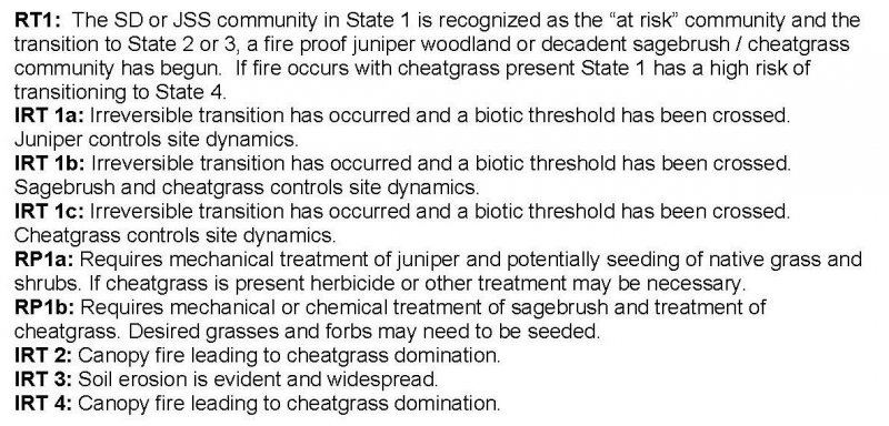
Disturbance outside the normal range of variability may cause a decrease in bluebunch wheatgrass, the preferred perennial bunchgrass on this site. As bluebunch wheatgrass declines, Sandberg’s bluegrass increases along with shrub/tree species such as sagebrush and juniper. The potential for cheatgrass invasion is increased as the site deteriorates (State 1). The Juniper Shrub Steppe and Sagebrush Dominant phases within State 1 are recognized as the “at risk” plant communities. Phases are included in the model diagram image.
Multiple pathways of change from State 1 Juniper Shrub Steppe phase exist. If fire is suppressed juniper will continue to expand and out-compete both the bunchgrass and sagebrush understory. When fine fuels are reduced to the point where fire no longer will carry, the site has crossed a threshold and transitioned to State 3 with no way for restoration; Juniper Shrub Steppe phase (fireproof). Cheatgrass can invade these ecological sites and with inappropriate grazing will likely be found under the juniper canopy. The Juniper Shrub Steppe phase within State 3 has the potential to transition to State 4 with a canopy fire. Maturation of the juniper community within State 3 leads to a juniper woodland with no more than a trace amount of sagebrush and deep-rooted perennial bunchgrasses. Juniper controls nutrient cycling, energy capture and water use (State 3 Juniper Woodland phase). The potential for soil erosion increases as the juniper woodland matures and the understory plant community cover declines. The risk of an irreversible transition over an abiotic threshold to the Juniper Woodland erosional phase of State 6 increases with increasing slope and increasing bare ground.
With no fire, overgrazing and/or severe drought within State 1 Juniper Shrub Steppe phase the perennial bunchgrasses will continue to decline while cheatgrass abundance increases and sagebrush matures further facilitating the decline in bunchgrass. This feedback continues until sagebrush and cheatgrass control stand dynamics (State 2). Fire within this community can trigger an irreversible transition to State 4. The potential for soil erosion increases as the sagebrush community matures and the understory plant community cover declines. The risk of an irreversible transition over an abiotic threshold to the erosional phase of State 6 increases with increasing slope and increasing bare ground.
When this site is seeded (typically to non-native grass and forb communities), abusive grazing can cause the seeded State 5 to transition either to a decadent sagebrush cover type or a juniper dominated system. With abusive grazing and fire the seeded rangeland has the potential to convert to State 4.
Treatment Response:
This site lack resilience to disturbance primarily due to the characteristic annual precipitation of less than 12 inches along with south exposure and droughty soils. The restoration pathway from State 3 to State 1 indicates potential for rehabilitation of the juniper controlled plant community exists. The potential for success is limited. Treatment of juniper should incorporate methods to provide soil cover to facilitate microsites for seedling establishment along with seeding of bluebunch wheatgrass, forbs and sagebrush. Fire is not a recommended tool of rehabilitation due to the increased risk presented by cheatgrass presence. Restoration pathway from State 2 to 1 captures that the treatment of the Sagebrush and Cheatgrass phase would require chemical or mechanical control of the sagebrush and cheatgrass along with seeding. The potential for failure of rehabilitation projects on this site is high. Every effort should be made to prevent threshold forcing events from occurring.
Grazing management favoring shrubs and/or severe drought will reduce the perennial bunchgrasses in the understory.
T1B
-
Less frequent fire and/or extended drought reduces perennial bunch grasses and allows for an increase in shrub/tree species.
T1C
-
Catastrophic fire, multiple fires, and/or soil disturbing treatments/activities in the presence of invasive species
R2A
-
Requires mechanical treatment of juniper and potentially seeding of native grass and
shrubs. If cheatgrass is present herbicide or other treatment may be necessary.
Chronic, heavy growing season grazing. Severe fire likely following shrub and tree fuel accumulation.
R3A
-
Juniper stand removal and seeding of desired cultivated species: herbicide may be necessary
T3A
-
Catastrophic fire and/ or failed rehabilitation treatment or combination of both. Inappropriate grazing management in the presence of annual non-native species.
T3B
-
Chronic, heavy growing season grazing. Severe fire likely following shrub and tree fuel accumulation.
T4A
-
Chronic, heavy growing season grazing. Severe fire.
R5A
-
Chronic, heavy growing season grazing will decrease bunchgrasses, increase Sandberg bluegrass and shrubs.
T5A
-
Time without disturbance allows for trees to outcompete understory
Community phases are maintained by fire and are not negatively affected by appropriate grazing. Inappropriate grazing, reduced fire frequency or both lead to increased sagebrush and juniper cover and decreased cover of understory species, however the Sagebrush Dominant or Juniper Shrub Steppe community phase is still susceptible to fire. In addition, due to the south facing aspect and shallow soil typical of this ecological site, the risk of cheatgrass invasion with inappropriate grazing is significant. Sites exhibit low resilience to disturbance.
The Reference Plant Community is dominated by bluebunch wheatgrass. Needlegrasses are common in the stand. Vegetative composition of the community is approximately 90 percent grasses, 8 percent forbs, and 2 percent shrubs.
Figure 7. Annual production by plant type (representative values) or group (midpoint values)
Table 5. Annual production by plant type
Plant type
Low (lb/acre)
Representative value (lb/acre)
High (lb/acre)
Grass/Grasslike
670
835
1005
Forb
70
90
110
Shrub/Vine
50
60
70
Tree
10
15
15
Total
800
1000
1200
Community 1.2 Sagebrush Steppe
Basin big sagebrush is approximately 3 percent of the community with bluebunch wheatgrass at 60 percent and Thurber's needlegrass is approximately 30 percent.
Community 1.3 Sagebrush Dominant or Juniper Shrub Steppe
Basin big sagebrush and Juniper dominant.
Pathway 1.1A Community 1.1 to 1.2
Pathway 1.2A Community 1.2 to 1.1
Pathway 1.2B Community 1.2 to 1.3
Pathway 1.3A Community 1.3 to 1.1
Pathway 1.3B Community 1.3 to 1.2
State 2 Sagebrush Dominant
Recognized by the need to mechanically or chemically treat the sagebrush. The presence of cheatgrass and site characteristics indicate prescribed burning as an extreme risk. Sagebrush and Cheatgrass phase with sagebrush dominant, bareground interspaces with a trace of bluebunch wheatgrass under the brush canopy and an increase in Sandberg bluegrass, broom snakeweed and rabbitbrush.
Decadent sagebrush with cheatgrass, Sandberg bluegrass, broom snakeweed squirreltail, gray horsebrush, and annual forbs.
State 3 Juniper Dominant
Recognized by the need to mechanically treat the juniper woodland. The presence of cheatgrass and site characteristics indicate prescribed burning as an extreme risk. Juniper Shrub Steppe phase with Juniper dominant, bareground interspaces with a trace of bluebunch wheatgrass under the tree canopy and an increase in Sandberg bluegrass. Sagebrush is stressed and dying (Juniper Shrub Steppe phase). As the juniper woodland matures, sagebrush and bluebunch wheatgrass are eliminated and the potential for soil erosion increases (Juniper Woodland phase).
Juniper, Sandberg bluegrass, trace of Idaho fescue, and a trace of cheatgrass.
State 4 Cheatgrass
Cheatgrass dominated state maintained through frequent fire.
[For this site: cheatgrass can be interpreted to mean any invasive annual grass (e.g. medusahead, ventenata). Soil textures with higher clay percentages have higher susceptibility to medusahead.]
State 5 is a common occurrence on many ecological sites therefore it has been included in the model. Overgrazing of the seeded rangeland can cause a reduction in deep rooted perennial grasses in favor of Sandberg bluegrass, cheatgrass, sagebrush and juniper. State 5 can transition to any of the other alternative states with inappropriate grazing, fire, or both.
Crested wheatgrass, Sherman, bluebunch wheatgrass, alfalfa, and Kochia.
Community 5.2 Shrub and Seeded Grasses
Shrubs and juniper with seeded grasses.
Pathway 5.1A Community 5.1 to 5.2
Pathway 5.2A Community 5.2 to 5.1
State 6 Eroded
Eroded version of State 2, 3, 4 or 5. The site has crossed an abiotic threshold characterized by soil loss and lack of seedbank thereby resulting in the inability to sustain the establishment of perennial plants including juniper. All ecological processes, hydrologic cycle, nutrient cycle and energy capture have been significantly changed.
Community dynamic is based on what state (State 2, 3, 4, or 5) the community that has shifted across the threshold.
Transition T1A State 1 to 2
Grazing management favoring shrubs and/or severe drought will reduce the perennial bunchgrasses in the understory.
Transition T1B State 1 to 3
Less frequent fire and/or extended drought reduces perennial bunch grasses and allows for an increase in shrub/tree species.
Transition T1C State 1 to 4
Catastrophic fire, multiple fires, and/or soil disturbing treatments/activities in the presence of invasive species
Restoration pathway R2A State 2 to 1
Requires mechanical treatment of juniper and potentially seeding of native grass and shrubs. If cheatgrass is present herbicide or other treatment may be necessary.
Chronic, heavy growing season grazing. Severe fire likely following shrub and tree fuel accumulation.
Restoration pathway R3A State 3 to 1
Juniper stand removal and seeding of desired cultivated species: herbicide may be necessary
Transition T3A State 3 to 4
Catastrophic fire and/ or failed rehabilitation treatment or combination of both. Inappropriate grazing management in the presence of annual non-native species.
Transition T3B State 3 to 6
Chronic, heavy growing season grazing. Severe fire likely following shrub and tree fuel accumulation.
Transition T4A State 4 to 6
Chronic, heavy growing season grazing. Severe fire.
Restoration pathway R5A State 5 to 2
Chronic, heavy growing season grazing will decrease bunchgrasses, increase Sandberg bluegrass and shrubs.
Transition T5A State 5 to 3
Time without disturbance allows for trees to outcompete understory
Transition T5B State 5 to 6
With overgrazing alone.
Additional community tables
Table 6. Community 1.1 plant community composition
LIVESTOCK
This site is suited to use by cattle, sheep, and horses in all seasons under a planned grazing system. Limitations are clayey soils, steepness of slope, and coarse fragments. Use should be postponed until the soils are firm enough to avoid trampling damage and soil compaction.
WILDLIFE
The southerly aspect of this site offers warm temperatures and early spring growth that attracts several grazing and browsing forms of wildlife and gallinaceous birds in winter and spring. It is an important wintering area for mule deer.
Hydrological functions
The soils are in hydrologic groups C and D. The soils of this site have moderately high to high runoff potential.
Wood products
This site is susceptible to increase in western juniper. Where this has occurred, the site will yield fence posts, firewood, and specialty products.
Other information
Increase in western juniper and the subsequent competition for moisture will lead to a reduction of available forage. Overgrazing can easily reduce ground cover and accelerate soil loss. Improving infiltration and permeability, and reducing runoff should be the immediate goal of juniper control. Mechanical seeding is not well suited to this site due to extremely stony surfaces and steeper slopes.
Stringham, Tamzen, 2007. Final Report for USDA Ecological Site Description. Oregon State University, Corvallis, Oregon.
Contributors
A. Bahn, C. Brooks - Updated 2004 Original Authors: A Bahn, J. Thompson, B. O'Donnell, H. Barrett - 6/89 Andrew Neary - table population and edits 2021
Approval
Kirt Walstad, 12/13/2023
Rangeland health reference sheet
Interpreting Indicators of Rangeland Health is a qualitative assessment protocol used to
determine ecosystem condition based on benchmark characteristics described in the Reference Sheet. A suite of 17 (or
more) indicators are typically considered in an assessment. The ecological site(s) representative of an assessment
location must be known prior to applying the protocol and must be verified based on soils and climate. Current plant
community cannot be used to identify the ecological site.
Author(s)/participant(s)
Contact for lead author
Date
08/06/2012
Approved by
Kirt Walstad
Approval date
Composition (Indicators 10 and 12) based on
Annual Production
Indicators
Number and extent of rills:
None to few on steeper slopes, moderate sheet & rill erosion hazard
Presence of water flow patterns:
None to few on steeper slopes
Number and height of erosional pedestals or terracettes:
None
Bare ground from Ecological Site Description or other studies (rock, litter, lichen, moss, plant canopy are
not bare ground):
10-20%
Number of gullies and erosion associated with gullies:
None
Extent of wind scoured, blowouts and/or depositional areas:
None, slight wind erosion hazard
Amount of litter movement (describe size and distance expected to travel):
Fine - limited movement
Soil surface (top few mm) resistance to erosion (stability values are averages - most sites will show a range
of values):
Significantly resistant to erosion: aggregate stability = 4-6
Soil surface structure and SOM content (include type of structure and A-horizon color and thickness):
Moderately deep to deep, well drained stony clay loams and clay loams: moderate OM (2-4%)
Effect of community phase composition (relative proportion of different functional groups) and spatial
distribution on infiltration and runoff:
Moderate ground cover (50-60%) and gentle to very steep slopes (12-70%) moderately limit rainfall impact and overland flow
Presence and thickness of compaction layer (usually none; describe soil profile features which may be
mistaken for compaction on this site):
None
Functional/Structural Groups (list in order of descending dominance by above-ground annual-production or live foliar
cover using symbols: >>, >, = to indicate much greater than, greater than, and equal to):
Amount of plant mortality and decadence (include which functional groups are expected to show mortality or
decadence):
Normal decadence and mortality expected
Average percent litter cover (%) and depth ( in):
Expected annual annual-production (this is TOTAL above-ground annual-production, not just forage annual-production):
Favorable: 1200, Normal: 1000, Unfavorable: 800 lbs/acre/year at high RSI (HCPC)
Potential invasive (including noxious) species (native and non-native). List species which BOTH characterize
degraded states and have the potential to become a dominant or co-dominant species on the ecological site if
their future establishment and growth is not actively controlled by management interventions. Species that become
dominant for only one to several years (e.g., short-term response to drought or wildfire) are not invasive
plants. Note that unlike other indicators, we are describing what is NOT expected in the reference state for the
ecological site:
Perennial brush species will increase with deterioration of plant community. Western Juniper readily invades the site. Cheatgrass and Medusahead invade sites that have lost deep rooted perennial grass functional groups.
Perennial plant reproductive capability:
All species should be capable of reproducing annually
The Ecosystem Dynamics Interpretive Tool is an information system framework developed by the USDA-ARS Jornada Experimental Range, USDA Natural Resources Conservation Service, and New Mexico State University.
Click on box and path labels to scroll to the respective text.
Grazing management favoring shrubs and/or severe drought will reduce the perennial bunchgrasses in the understory.
T1B
-
Less frequent fire and/or extended drought reduces perennial bunch grasses and allows for an increase in shrub/tree species.
T1C
-
Catastrophic fire, multiple fires, and/or soil disturbing treatments/activities in the presence of invasive species
R2A
-
Requires mechanical treatment of juniper and potentially seeding of native grass and
shrubs. If cheatgrass is present herbicide or other treatment may be necessary.
Chronic, heavy growing season grazing. Severe fire likely following shrub and tree fuel accumulation.
R3A
-
Juniper stand removal and seeding of desired cultivated species: herbicide may be necessary
T3A
-
Catastrophic fire and/ or failed rehabilitation treatment or combination of both. Inappropriate grazing management in the presence of annual non-native species.
T3B
-
Chronic, heavy growing season grazing. Severe fire likely following shrub and tree fuel accumulation.
T4A
-
Chronic, heavy growing season grazing. Severe fire.
R5A
-
Chronic, heavy growing season grazing will decrease bunchgrasses, increase Sandberg bluegrass and shrubs.
T5A
-
Time without disturbance allows for trees to outcompete understory