
Natural Resources
Conservation Service
Ecological site R010XC030OR
SR Cool 9-12 PZ
Last updated: 5/13/2025
Accessed: 02/09/2026
General information
Approved. An approved ecological site description has undergone quality control and quality assurance review. It contains a working state and transition model, enough information to identify the ecological site, and full documentation for all ecosystem states contained in the state and transition model.
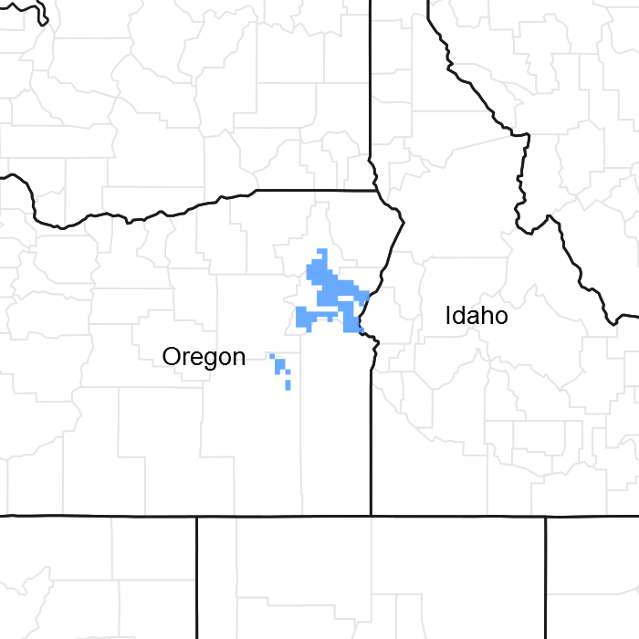
Figure 1. Mapped extent
Areas shown in blue indicate the maximum mapped extent of this ecological site. Other ecological sites likely occur within the highlighted areas. It is also possible for this ecological site to occur outside of highlighted areas if detailed soil survey has not been completed or recently updated.
MLRA notes
Major Land Resource Area (MLRA): 010X–Central Rocky and Blue Mountain Foothills
MLRA 10 in Oregon has 4 sub-divisions; B10XA, B10XB, B10XC & B10XY. B10XA is in the western portion of the MLRA and is designated as the Pumice Zone with ash and pumice (Mazama eruption origin) in the soils and old growth western juniper (Juniperus occidentalis). B10XB is designated as the John Day/Clarno Zone and is differentiated by its clay soils and invasive western juniper. This ecological site occurs in B10XC which is in the south and eastern portion of the MLRA and is designated as the Upper Snake River Lava Plains and Hills Zone and has predominantly silty clay loam soils over clay, invasive juniper and a greater predominance of shrubs. B10XY denotes ecological sites that occur throughout the MLRA along stream bottoms, riparian areas, meadows, swales and fans.
Classification relationships
This ecological site is most likely within the macro-group M169 Great Basin and Intermountain Tall Sagebrush Shrubland and Steppe, US National Vegetation Classification (USNVC).
This ecological site is in EPA Ecoregions 11i-Continental Zone Foothills, 11k Blue Mt. Basins and 11d-Melange.
Ecological site concept
This ecological site is found on moderately deep to deep soils in the 9-12 inch precipitation zone in Eastern Oregon. The reference community phase is dominated by a unique combination of Wyoming big sage & Idaho fescue. The soil temperature regime is mesic to near-frigid (cool mesic) where the mesic/frigid break occurs primarily around 5000 ft. elevation; however, typical elevations for this site range from 2700 to 4400 ft. The soil moisture regime is aridic (9-12" precipitation)with a xeric moisture sub-class. The typical surface textures are silt loams and silty clay loams and have a surface physical crust and hexagonal cracking when stable.
Associated sites
| R010XC036OR |
SR Shallow Cool 9-12 PZ This site occurs on shallow soils. |
|---|---|
| R010XC043OR |
SR South 9-12 PZ This site occurs on the south facing aspect. |
| BX010X00C050 |
Shallow South 9-12 PZ Snake River Warm Plains This site occurs on south facing, shallow soils. |
| R010XC065OR |
SR Cool North 9-12 PZ This occurs on the north aspects. |
Similar sites
| R010XC036OR |
SR Shallow Cool 9-12 PZ This can be differentiated by its shallow soil and lower production. |
|---|
Table 1. Dominant plant species
| Tree |
Not specified |
|---|---|
| Shrub |
(1) Artemisia tridentata ssp. wyomingensis |
| Herbaceous |
(1) Festuca idahoensis |
Physiographic features
This site occurs on terraces, tablelands, alluvial fans and rolling uplands. Slopes range from 2 to 12 percent. Elevations range from 2700 to 4400 feet.
Table 2. Representative physiographic features
| Landforms |
(1)
Terrace
(2) Plateau (3) Alluvial fan |
|---|---|
| Flooding frequency | None |
| Ponding frequency | None |
| Elevation | 2,700 – 4,400 ft |
| Slope | 2 – 12% |
| Aspect | Aspect is not a significant factor |
Climatic features
The annual precipitation ranges from 9 to 12 inches, most of which occurs in the form of snow during the months of December through March. Localized, occasionally severe, convectional storms occur during the summer. The soil temperature regime is cool mesic with a mean annual air temperature of 45 degrees F. Temperature extremes range from -20 to 100 degrees F. The frost free period ranges from 86 to 110 days. The optimum period for plant growth is from April through June.
Table 3. Representative climatic features
| Frost-free period (average) | 98 days |
|---|---|
| Freeze-free period (average) | 132 days |
| Precipitation total (average) | 11 in |
Figure 2. Monthly precipitation range
Figure 3. Monthly average minimum and maximum temperature
Figure 4. Annual precipitation pattern
Figure 5. Annual average temperature pattern
Influencing water features
Soil features
The soils of this site are typically moderately deep to deep and well drained. Typically the surface layer is a silt loam to silty clay loam 4 to 12 inches thick. The subsoil is a silt loam to clay loam 8 to 40 inches thick. Depth to bedrock, an indurated pan or lacustrine sediments range from 20 to 60 inches. Permeability is moderately slow to moderate. The available water holding capacity (AWC) is about 2.5 to 8 inches for the profile. The erosion potential is moderate to severe.
Table 4. Representative soil features
| Parent material |
(1)
Alluvium
–
basalt
(2) Colluvium – tuff (3) Loess – quartz-diorite |
|---|---|
| Surface texture |
(1) Ashy silt loam (2) Gravelly silty clay loam (3) Very cobbly loam |
| Family particle size |
(1) Clayey |
| Drainage class | Well drained |
| Permeability class | Moderately slow to moderate |
| Soil depth | 20 – 60 in |
| Surface fragment cover <=3" | 20% |
| Surface fragment cover >3" | 2% |
| Available water capacity (0-40in) |
2.4 – 8.1 in |
| Calcium carbonate equivalent (0-40in) |
Not specified |
| Electrical conductivity (0-40in) |
Not specified |
| Sodium adsorption ratio (0-40in) |
Not specified |
| Soil reaction (1:1 water) (0-40in) |
6.6 – 7.8 |
| Subsurface fragment volume <=3" (Depth not specified) |
14% |
| Subsurface fragment volume >3" (Depth not specified) |
2 – 20% |
Ecological dynamics
This site is dominated by deep-rooted, cool-season bunchgrasses, although it is predominantly Idaho Fescue with varying amounts of Wyoming big sage and other associated shrubs. Thurber’s needlegrass increases on loamy surfaces and on droughty sites. Bluebunch wheatgrass increases on clayey surfaces. Wyoming big sagebrush is dominant at lower precipitations while basin big sagebrush increases at higher precipitations. Wild crab apple is associated with sediments including those interlaid with diatomaceous earth. Production increases at the upper end of the precipitation zone. Key abiotic characteristics of this site include crusting and cracking of the soil surface (provides soil stability to the fine surface soil textures), soil pedestaling around the bunchgrasses, an aridic soil moisture regime, and a soil temperature regime of mesic near frigid (designated as "cool").
Primary natural disturbances affecting this ecological site are wildfire, herbivory and periodic drought.
• Wildfire: Wyoming big sage is a non-sprouting shrub and is maintained and controlled by natural fire regimes. Seasonality, intensity and frequency of natural fire combined with weather events determine plant community dynamics. Historically, fire return intervals were long enough for Wyoming big sagebrush to re-establish and fires occurred when cool-season bunchgrasses were dormant in the late summer to early fall. With frequent fire and continued disturbance (mechanical, drought, herbivory), sagebrush is severely impacted, rabbitbrush increases slightly and annuals and noxious biennial forbs continue to invade.
• Herbivory: Herbivory effects on the plant community dynamics will depend on diet preferences of species that utilize the vegetation (browsers vs. grazers), the intensity of defoliation and the ability of the plants to recover from defoliation before being defoliated again. Overuse by grazing species (elk, cattle, horses) will result in a decrease of Idaho fescue while Sandberg bluegrass increases. With excessive and repeated herbivory, Idaho fescue drops out of the plant community, Wyoming big sagebrush and Sandberg bluegrass will co-dominate. Cheatgrass (Bromus tectorum), medusahead (Taeniatherum caput-medusae), other annuals forbs, biennial weeds and bulbous bluegrass (Poa bulbosa) are invaders but are held in check by the Sandberg bluegrass and its persistent root mats that create an almost impenetrable layer in the soil to seed germination and establishment.
• Drought: The deep-rooted perennial bunchgrasses, sagebrush and associated species are adapted to receiving limited annual precipitation. Drought related mortality is generally low in this community type. Prolonged drought, however, will result in an over-all decline in the grass-forb component of the plant community and reduced annual growth and seedling recruitment of Wyoming big sagebrush.
State and transition model
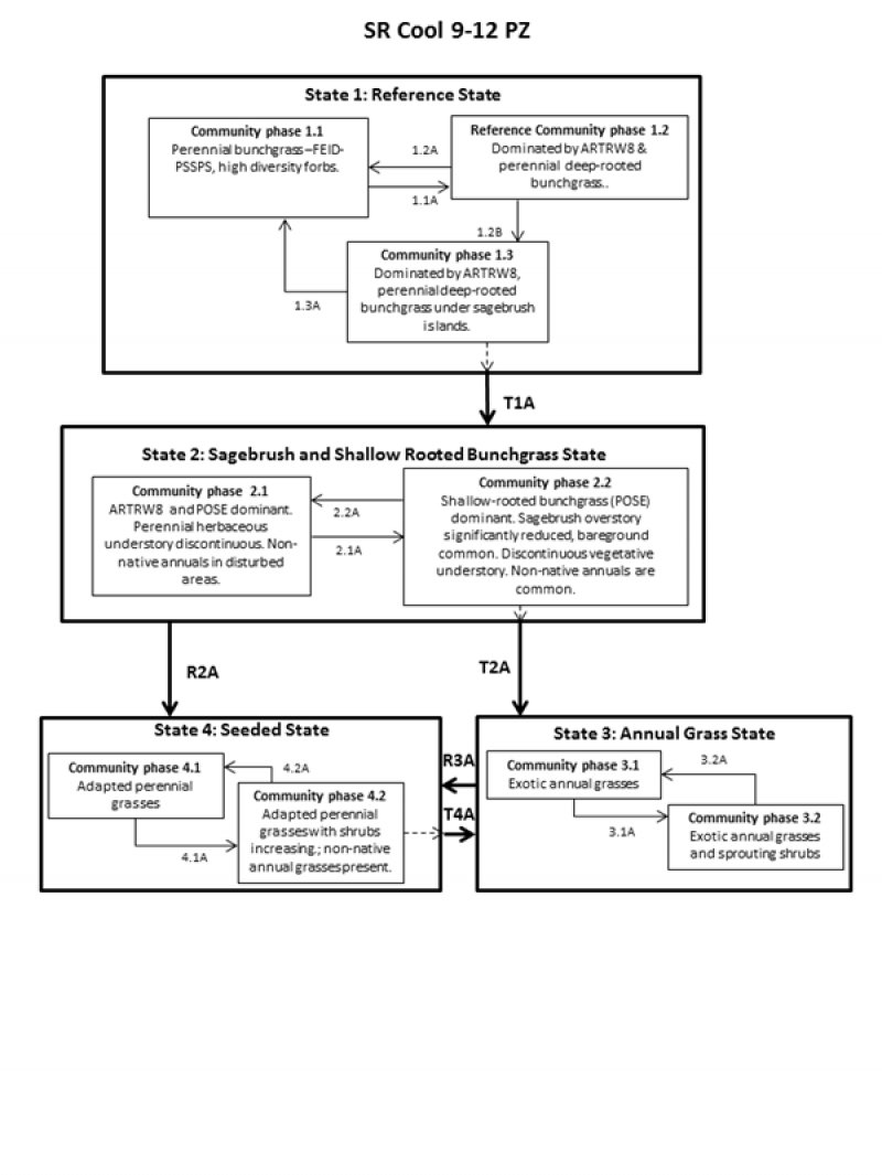
Figure 6. SR Cool 9-12 PZ state and transition model
More interactive model formats are also available.
View Interactive Models
More interactive model formats are also available.
View Interactive Models
Click on state and transition labels to scroll to the respective text
State 1 submodel, plant communities
State 2 submodel, plant communities
State 3 submodel, plant communities
State 4 submodel, plant communities
State 1
Reference
The reference state is considered to be representative of this ecological site under naturally stable, pre-European settlement conditions. This state is dominated by Idaho fescue and Wyoming big sagebrush. Bluebunch wheatgrass, Thurbers needlegrass, and Sandberg bluegrass are common. Other associated species include bottlebrush squirreltail, wild crabapple, horsebrush, and rabbitbrush. Common forbs include prickly phlox, lupine, buckwheat, owl clover, fleabane daisy, and lomatium. These plants maintain the nutrient cycles, organic matter accumulation, and hydrologic functions in their rooting depth. Energy capture by cool season perennial grasses is limited primarily to fall, spring and early summer. As the deeper rooted woody plants increase, the nutrient cycles, organic matter accumulation and hydrologic functions are extended deeper into the soil profile. Energy capture is extended through the summer season. Periodic fire (typically between 15-70 year intervals) prevents the non-sprouting woody plants from becoming dominant in this state. Idaho fescue is at its lowest limit of moisture tolerance and quickly drops out of the plant community with disturbance. Three plant community phases occur in the Reference State differentiated by the amount of sagebrush and deep-rooted perennial grasses that are present.
Community 1.1
Bunchgrass-forb community phase

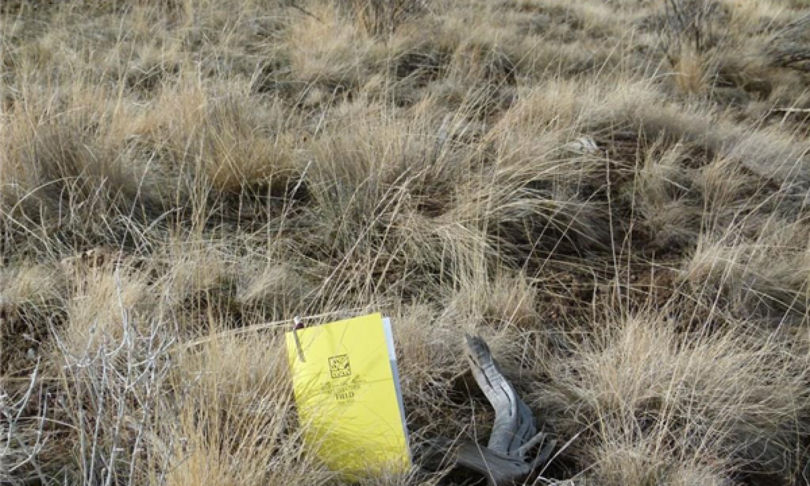
Figure 7. Community phase 1.1 Grass-Forb phase, Lookout soil series 2/19/13 photo by Cici Brooks
The potential native community is dominated by Idaho fescue and bluebunch wheatgrass. Sandberg bluegrass is the dominant shallow-rooted perennial grass. Thurbers needlegrass, bottlebrush squirreltail, basin wildrye, and a variety of forbs are also present. Shrubs include Wyoming big sagebrush, rabbitbrush, and wild crab apple. Ecological processes of this state are driven by the deep rooted perennial grasses. Vegetative composition of the community by weight is approximately 80 percent grasses, 15-20 percent forbs, and 2-3 percent shrubs. The approximate foliar cover is 70 percent, basal cover is approximately 11 percent, and bare ground is approximately 10%.
Community 1.2
Reference - Bunchgrass-shrub community phase
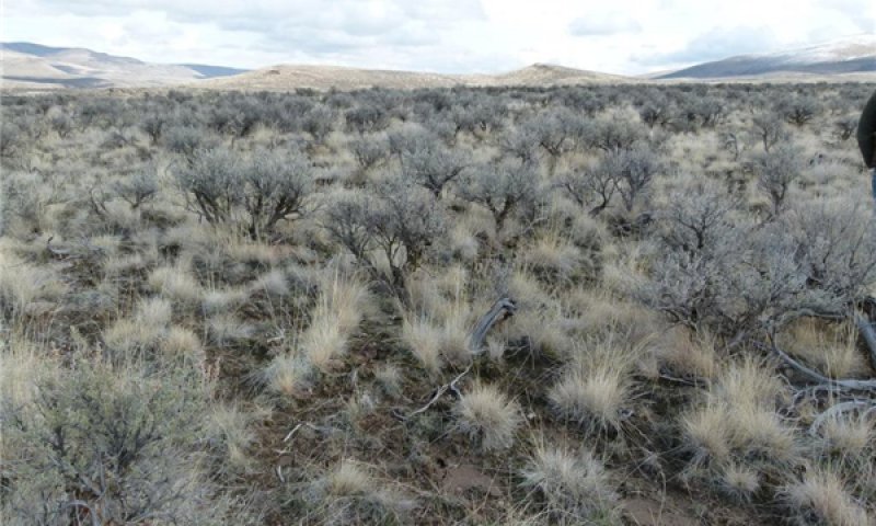
Figure 8. Community phase 1.2 Grass-Shrub phase, Elijah soil series (7000) 2/19/13 photo by Cici Brooks
This plant community is represented by the dominant deep-rooted perennial bunchgrasses with an increase in sagebrush and other shrub cover. Wyoming big sagebrush is the dominant shrub; other shrubs that may occur include wild crabapple, horsebrush, and rabbitbrush. The ecological processes are controlled by the perennial grasses and shrubs. Grasses comprise 80% of the community by weight, forbs 10%, and shrubs 10%. Foliar cover is 67%, basal cover 12%, and bare ground 8%.
Figure 9. Annual production by plant type (representative values) or group (midpoint values)
Table 5. Annual production by plant type
| Plant type | Low (lb/acre) |
Representative value (lb/acre) |
High (lb/acre) |
|---|---|---|---|
| Grass/Grasslike | 625 | 860 | 1050 |
| Shrub/Vine | 100 | 200 | 300 |
| Forb | 25 | 40 | 50 |
| Total | 750 | 1100 | 1400 |
Figure 10. Plant community growth curve (percent production by month). OR4471, B10 SR Cool 9-12 pz. SR Cool 9-12 pz RPC Growth Curve.
| Jan | Feb | Mar | Apr | May | Jun | Jul | Aug | Sep | Oct | Nov | Dec |
|---|---|---|---|---|---|---|---|---|---|---|---|
| J | F | M | A | M | J | J | A | S | O | N | D |
| 0 | 0 | 5 | 15 | 25 | 25 | 15 | 0 | 10 | 5 | 0 | 0 |
Community 1.3
Sagebrush dominant phase
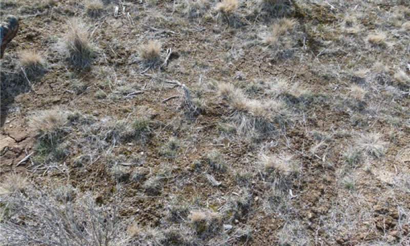
Figure 11. Community Phase 1.3 Sagebrush dominant phase, Virtue series (172B) 2/19/13 photo by Cici Brooks
The sagebrush dominant phase is the "at-risk" plant community phase for the reference state. It is dominated by Wyoming big sagebrush with a loss of vigor and density of deep-rooted perennial bunchgrass (Idaho fescue, and Thurbers needlegrass). Approximately one deep-rooted perennial bunchgrass in three square ft. is the minimum plant density before the risk of crossing the threshold into state 2 is exceeded. Shallow-rooted perennial grasses have increased and occupy the shrub interspaces. Wyoming big sagebrush controls the ecological processes in this plant community. Grasses compose 35-55% of the community by weight, forbs 10%, and shrubs 20-30%. Foliar cover is approximately 55%, basal cover approximately 4-8%, and bare ground approximately 20%.
Pathway 1.1A
Community 1.1 to 1.2


Time since fire, excessive and repeated herbivory, and drought will favor an increase in shrubs.
Pathway 1.2A
Community 1.2 to 1.1


Low to moderate intensity wildfire and wet cycles favor the return to the bunchgrass phase.
Pathway 1.2B
Community 1.2 to 1.3


Continued time since fire with excessive and repeated herbivory and/or continued drought will favor the increase of shrubs and a decline in deep-rooted perennial grasses.
Pathway 1.3A
Community 1.3 to 1.1


Prescribed grazing, wet cycles, natural low intensity wildfires will favor a return to the grass-forb phase.
State 2
Sagebrush and Shallow-rooted Bunchgrass
This state is represented by varying amounts of Wyoming big sagebrush and Sandberg bluegrass. Deep-rooted perennial bunchgrasses are confined to protected areas within the shrub canopy. Plant structure (height) is less due to the decline of the deep-rooted bunchgrasses. Bare ground has increased and non-native annual grasses and forbs are present. Ecological processes are controlled by the shallow-rooted perennial grasses and sagebrush. Nutrient cycling, moisture capture, and organic matter have decreased and are concentrated in the top 4 inches of the soil profile due to lower production of grasses and less root biomass. Fire frequency has decreased due to the decrease in fuel loads. Soil surface differences between this state and the reference state include a decrease in the amount of pedestals and an increase in bare ground.
Community 2.1
Wyoming big sagebrush-Sandberg bluegrass phase
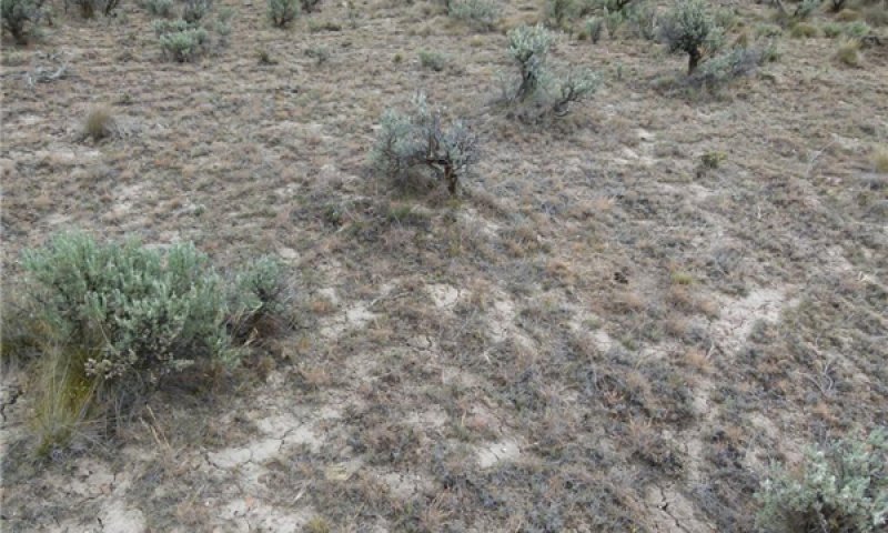
Figure 12. Community phase 2.1, Burntriver soil series (33C) 6/19/13 photo by Cici Brooks
Wyoming big sagebrush and Sandberg bluegrass are the dominant species in this plant community with minor amounts of bottlebrush squirreltail, Thurbers needlegrass, bluebunch wheatgrass, and Idaho fescue. There are varying amounts of other sprouting shrubs such as rabbitbrush or horsebrush. Big sagebrush and the shallow-rooted perennial grasses control the ecological processes in this community phase. Sandberg bluegrass forms a root mat belowground that suppresses the invasion of annual grass. Grasses compose 55-60% of the community by weight, forbs 10%, and shrubs 25-30%.
Community 2.2
Sandberg bluegrass-annual grass phase
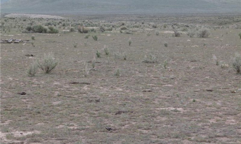
Figure 13. Community phase 2.2, Virtue soil series (171B) 4/18/13 photo by Cici Brooks
This plant community is characterized by Sandberg bluegrass, bottlebrush squirreltail, and non-native annual grasses and forbs. Sagebrush and other shrub species are limited to <10% of the plant community. This is the "at risk" community that can cross the threshold toward an annual dominant state (state 3) when repeated soil disturbance from concentrated heavy herbivory or mechanical sources allows an increase in the annual grasses. Grasses compose 60-65% of the community by weight, forbs 10%, and shrubs <10%.
Pathway 2.1A
Community 2.1 to 2.2


Excessive soil disturbance, repeated heavy herbivory and/or brush management will decrease the shrub and perennial grass cover.
Pathway 2.2A
Community 2.2 to 2.1


Prolonged lack of fire favors encroachment of brush species.
State 3
Annual
This state is characterized by non-native annual grasses. The annual grasses out-compete the native plant community by capturing energy, nutrients, and soil moisture earlier, resisting herbivory, and producing a large amount of seed. Cheatgrass and medusahead germinate in the fall and establish a shallow root system that is able to elongate through the winter and capture early soil moisture. This creates adverse growing conditions for perennial species and effectively dries out the site. These annuals complete their growth by early summer and become prone to wildfires during the driest time of the year. The annual grasses produce a continuous, fine fuel source that favors hot, quick moving fires. Natural fire cycles are shortened to approximately 2-3 fires in 10 years. These fires create an ash, nitrogen-rich duff that aids the seed bank to monopolize the next flush of precipitation. Shallow rooted annual grasses are not able to access deeper moisture and complete their growing cycle when surface soil moisture is depleted. Soil organic matter decreases due to the loss of root masses that were provided by the deep-rooted perennials which are now replaced by these shallow-rooted annual grasses.
Community 3.1
Annual grass community phase
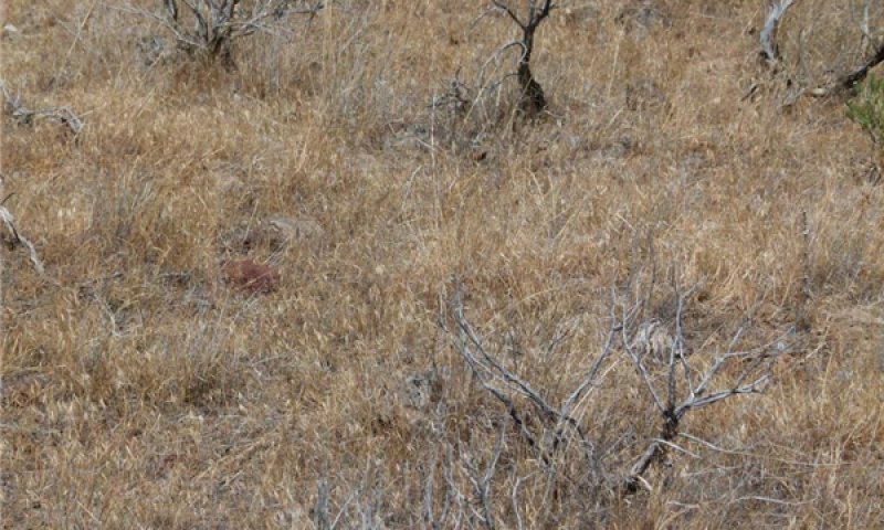
Figure 14. Community Phase 3.1 Annual grass dominant, Lookout soil series 7/18/13 photo by Cici Brooks
Non-native annual grasses in this community phase include cheatgrass, medusahead, and ventenata. Ground cover is continuous, bare ground is decreased, and plant productivity becomes dependent on annual precipitation cycles. Wildfire has become more frequent and flashy due to the continuous, dry standing fine fuels provided by the dried annual grasses at the hottest, driest time of year. Annual grasses can provide fall, winter, and spring forage for many wildlife and livestock species but are not suitable for summer grazing use. Shallow-rooted annual grasses are not able to access deeper moisture and complete their growing cycle when surface soil moisture is depleted. Potential vegetative composition by weight is 80% grasses, 20% annual forbs. Approximate ground cover (basal and foliar) is 50 to 90%.
Community 3.2
Annual grass-sprouting shrub plant community phase
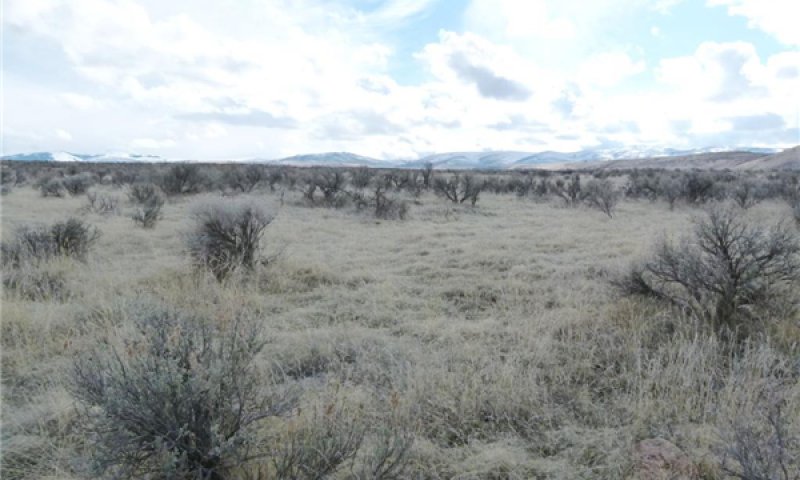
Figure 15. Community phase 3.2 Annual Grasses- sprouting shrubs, Virtue soil (172B) 2/19/13 photo by C. Brooks
This community phase exists where unburned patches of shrubs are invaded by non-native annual grasses. Decadent patches of Wyoming big sagebrush becomes vulnerable to subsequent fires which causes this community phase to cycle back to community phase 3.1. Sprouting shrubs like rabbitbrush and horsebrush are adapted to fire but will decrease with more frequent fires. Potential vegetative composition by weight is 85% annual grasses, 5% annual forbs, and 10% shrubs. Approximate ground cover (basal and foliar) is 70 to 90%.
Pathway 3.1A
Community 3.1 to 3.2


Decrease of fire frequency allows shrubs to increase.
Pathway 3.2A
Community 3.2 to 3.1


Increase of fire frequency will decrease the ability of sprouting shrubs to maintain their presence in the plant community.
State 4
Seeded
This state is characterized by plantings of adapted species of grasses and forbs. The purpose of this practice is to reestablish deep rooted perennial plants that are able to access deeper moisture, decrease the fire frequency, improve soil organic matter, improve infiltration, and increase plant production. The nutrient cycle now occurs in the deeper root zone and energy capture happens from fall and early spring through early summer corresponding to the growing season of the seeded species.
Community 4.1
Seeded-Adapted perennial grass
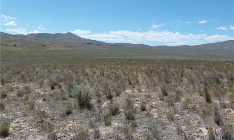
Figure 16. Community 4.1 Seeded-Adapted perennial grass, Elijah soil series (7000) 7/5/13 photo by Cici Brooks
This community phase is characterized by adapted species of grasses. Seeding risk is high in this precipitation zone and may require increased management to be successful. Seedbed preparation, species selection, timing of planting and allowing sufficient time for seedlings to become firmly established are critical to the success of the seeding. Shrubs may invade with time. Potential vegetative composition by weight is 90-95% grasses, 5% forbs. Approximate ground cover (basal and foliar) is 70 to 90%.
Community 4.2
Seeded grass - shrub plant community phase
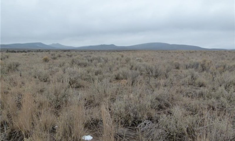
Figure 17. Seeded grass-shrub encroached phase, Elijah series (7000) 2/28/13 photo by Cici Brooks
This community phase is characterized by an increase in sagebrush and other shrub species that encroach from areas adjacent to the seeded area. This is the "at risk" community that can cross the threshold toward the annual dominant state (state 3). This occurs when the density of the perennial grass is reduced through repeated soil disturbance from concentrated heavy herbivory or mechanical sources which allows an increase in the annual grasses.
Pathway 4.1A
Community 4.1 to 4.2


Exclusion of fire and continued, heavy herbivory favors the establishment of shrubs.
Pathway 4.2A
Community 4.2 to 4.1


Prescribed fire, brush management, prescribed grazing will favor the deep-rooted perennial grasses.
Transition T1A
State 1 to 2
Disturbances which cause an increase in bare ground, loss of deep-rooted perennial grasses, increase in shallow-rooted perennial grasses, increase in shrubs and the introduction of non-native annual grasses will cause the plant community to cross a threshold. Triggers: control of fire, excessive and repeated herbivory, and prolonged drought.
Transition T2A
State 2 to 3
Soil disturbance, drought, repeated excessive herbivory, brush management followed by disturbance will decrease perennial species and favor the ability for annuals to increase.
Restoration pathway R2A
State 2 to 4
Mechanical seedbed preparation and seeding to adapted species will restore functions that benefit deep rooted grasses.
Restoration pathway R3A
State 3 to 4
Mechanical seedbed preparation and seeding to adapted species will restore functions that are benefitted by deep rooted grasses.
Transition T4A
State 4 to 3
Soil disturbance or repeated heavy herbivory or prolonged drought and high intensity frequent wildfires will favor annual grasses.
Additional community tables
Table 6. Community 1.2 plant community composition
| Group | Common name | Symbol | Scientific name | Annual production (lb/acre) | Foliar cover (%) | |
|---|---|---|---|---|---|---|
|
Grass/Grasslike
|
||||||
| 1 | Dominant, perennial, deep rooted bunchgrass | 300–1200 | ||||
| Idaho fescue | FEID | Festuca idahoensis | 300–1200 | 2–58 | ||
| 2 | Sub-dominant deep rooted perennial bunchgrass | 50–150 | ||||
| bluebunch wheatgrass | PSSPS | Pseudoroegneria spicata ssp. spicata | 0–50 | 0–30 | ||
| Thurber's needlegrass | ACTH7 | Achnatherum thurberianum | 0–50 | 0–21 | ||
| squirreltail | ELELE | Elymus elymoides ssp. elymoides | 5–30 | 0–3 | ||
| 4 | Dominant, perennial, shallow rooted grass | 30–60 | ||||
| Sandberg bluegrass | POSE | Poa secunda | 30–60 | 5–17 | ||
| 5 | Other grasses, grass-like | 30–100 | ||||
| western needlegrass | ACOC3 | Achnatherum occidentale | 0–20 | – | ||
| threadleaf sedge | CAFI | Carex filifolia | 0–20 | – | ||
| prairie Junegrass | KOMA | Koeleria macrantha | 0–20 | – | ||
| basin wildrye | LECI4 | Leymus cinereus | 3–20 | – | ||
| oniongrass | MEBU | Melica bulbosa | 0–10 | – | ||
| slender wheatgrass | ELTRT | Elymus trachycaulus ssp. trachycaulus | 0–10 | – | ||
|
Forb
|
||||||
| 7 | Dominant, perennial forbs | 40–80 | ||||
| lupine | LUPIN | Lupinus | 10–30 | – | ||
| phlox | PHLOX | Phlox | 5–20 | – | ||
| dwarf yellow fleabane | ERCH4 | Erigeron chrysopsidis | 5–20 | – | ||
| buckwheat | ERIOG | Eriogonum | 5–20 | – | ||
| desertparsley | LOMAT | Lomatium | 10–20 | – | ||
| 9 | Other forbs | 38–97 | ||||
| arrowleaf balsamroot | BASA3 | Balsamorhiza sagittata | 0–10 | – | ||
| common yarrow | ACMI2 | Achillea millefolium | 5–10 | – | ||
| western stoneseed | LIRU4 | Lithospermum ruderale | 5–10 | – | ||
| lupine | LUPIN | Lupinus | 5–10 | – | ||
| hawksbeard | CREPI | Crepis | 2–10 | – | ||
| milkvetch | ASTRA | Astragalus | 5–10 | – | ||
| bushy bird's beak | CORA5 | Cordylanthus ramosus | 0–5 | – | ||
| sagebrush buttercup | RAGL | Ranunculus glaberrimus | 2–5 | – | ||
| larkspur | DELPH | Delphinium | 2–5 | – | ||
| smallflower woodland-star | LIPA5 | Lithophragma parviflorum | 2–5 | – | ||
| harvest brodiaea | BREL | Brodiaea elegans | 2–5 | – | ||
| onion | ALLIU | Allium | 2–5 | – | ||
| pussytoes | ANTEN | Antennaria | 2–5 | – | ||
| twin arnica | ARSO2 | Arnica sororia | 2–5 | – | ||
| agoseris | AGOSE | Agoseris | 2–5 | – | ||
| rockcress | ARABI2 | Arabis | 0–2 | – | ||
| rough eyelashweed | BLSC | Blepharipappus scaber | 0–2 | – | ||
|
Shrub/Vine
|
||||||
| 11 | Dominant evergreen shrub | 150–350 | ||||
| Wyoming big sagebrush | ARTRW8 | Artemisia tridentata ssp. wyomingensis | 10–150 | 10–20 | ||
| 12 | Sub-dominant shrubs | 30–80 | ||||
| basin big sagebrush | ARTRT | Artemisia tridentata ssp. tridentata | 20–50 | – | ||
| wild crab apple | PERA4 | Peraphyllum ramosissimum | 10–50 | – | ||
| 13 | perennial sub-shrubs | 10–15 | ||||
| buckwheat | ERIOG | Eriogonum | 10–15 | – | ||
| 15 | Other shrubs | 20–100 | ||||
| threetip sagebrush | ARTR4 | Artemisia tripartita | 0–20 | – | ||
| yellow rabbitbrush | CHVI8 | Chrysothamnus viscidiflorus | 0–20 | – | ||
| antelope bitterbrush | PUTR2 | Purshia tridentata | 0–20 | – | ||
| littleleaf horsebrush | TEGL | Tetradymia glabrata | 0–20 | – | ||
Interpretations
Animal community
Livestock Grazing:
This site is suitable for livestock grazing use in the spring, early summer, and fall under a planned grazing system. Use should be postponed until the soils are firm enough to prevent trampling damage and soil compaction. Grazing management should be keyed for Idaho fescue. Deferred grazing or rest is recommended at least once every three years.
Native Wildlife Associated with the Plant Community States for SR Cool 9-12 PZ:
Rarely does one ecosite provide exclusive habitat for any one species; rather a complex of ecosites occurring together in association is better to evaluate the needs for wildlife in general. It is important to consider the spatial connectivity between vegetation communities across the landscape. A general interpretation for this specific ecological site follows in regards to species that occur and their habitat needs in relation to the plant community phases and transitions. Conservation and/or Management practices (NRCS practice code) that benefit each phase are highlighted but will need refinement based on associated ecological sites and management objectives. Not all conservation practices mentioned for each state will be needed based on management objectives and site specific conditions. Site specific recommendations are available at local NRCS field offices.
In the reference state, the SR Cool 9-12 Ecological Site provides habitat for over 120 species of birds and over 75 species of mammals. Several bird species indicative of the grassland community phase which is co-dominated by Idaho fescue and bluebunch wheatgrass include grasshopper sparrow, lark sparrow, and the vesper sparrow. Important big game species include elk, mule deer, and pronghorn. The grassland phase (big sagebrush less than 10%) is mostly unsuitable for larger ground nesting species like sage-grouse, except along edges near remaining sagebrush patches. As the composition of sagebrush increases, the site provides important habitat for sage thrasher, sage sparrow, pygmy rabbit, black-throated sparrow, and becomes yearlong habitat for sage-grouse. Conservation practices that benefit wildlife in this state include Prescribed Grazing (528), Fencing (382), Brush Management (314), Watering Facility (614) Spring Development (574), Prescribed Burning (378), Herbaceous Weed Control (315) & Upland Wildlife Habitat Management (645).
In state 2, deep-rooted bunchgrasses are replaced by shallow-rooted bunchgrass, sagebrush cover increases and plant diversity decreases. As brush cover increases, wildlife species which prefer grassland decrease. The state provides important habitat for sage-grouse and other sagebrush obligates, but habitat quality is diminished and at-risk of being lost to annual grasses. Decreases in screening (hiding cover) provided by large bunchgrasses results in reduced nest success for ground-nesting birds. The avifuana shifts to shrubland preference types of species such as the loggerhead shrike, lark sparrow, black-throated sparrow, and green-tailed towhee. Forb production and diversity are diminished, reducing the site’s value for pollinators, mule deer, pronghorn, and sage-grouse brood-rearing habitat. Conservation practices that benefit wildlife in this state include Prescribed Grazing (528), Fencing (382), Brush Management (314), Watering Facility (614) Spring Development (574), Prescribed Burning (378), Firebreak (394), Herbaceous Weed Control (315) & Upland Wildlife Habitat Management (645).
State 3, the annual grass state has very limited wildlife value. Where annual forbs are present, it provides limited habitat in the fall-spring to mule deer where hiding cover is present within close vicinity. Early green growth of annual grasses provides nutritious forage for grazing species but is not a dependable source of forage because production fluctuates widely with annual growing conditions. Conservation practices that benefit wildlife in this state include Range Planting (550; crosses threshold to state 4), Access Control (472), Early Successional Habitat Development/Management (647), Prescribed Grazing (528), Fencing (382), Watering Facility (614), Spring Development (574), Prescribed Burning (378), Firebreak (394) and Herbaceous Weed Control (315).
State 4, the seeded state, can be used as a treatment for the annual grass state. The seeded state can provide suitable plant habitat for the establishment of sagebrush and other native shrubs. The value of the seeded state for wildlife habitat depends largely on post seeding plant succession. As the structure and diversity increases the site provides habitat for a greater number of species. Conservation practices that benefit wildlife in this state include Prescribed Grazing (528), Fencing (382), Brush Management (314), Watering Facility (614) Spring Development (574), Prescribed Burning (378), Firebreak (394), Herbaceous Weed Control (315) & Upland Wildlife Habitat Management (645).
Hydrological functions
The soils of this site are typically in an upland topographic position. They have moderate runoff potential and medium infiltration rates when the hydrologic cover is high. Hydrologic cover is high when the Idaho fescue and other deep rooted bunchgrass component is >70 percent of potential.
Wood products
Not Applicable
Other products
Seeding of adapted perennial species is necessary when the site composition and production deteriorates. Recommendations may be obtained from the local Natural Resources Conservation Service field office.
Supporting information
Other references
Keeley, J.E.; Aplet, G.H.; Christensen, N.L.; Conard, S.C.; Johnson, E.A.;
Omi, P.N.; Peterson, D.L.; Swetnam, T.W. 2009. Ecological foundations for
fire management in North American forest and shrubland ecosystems. Gen.
Tech. Rep. PNW-GTR-779. Portland, OR: U.S. Department of Agriculture,
Forest Service, Pacific Northwest Research Station. 92 p.
Characteristics of sagebrush habitats and limitations to long-term conservation. Pages 146-184 in S. T. Knick and J. W. Connelly (editors). Greater Sage-Grouse: ecology and conservation of a landscape species and its habitats. Studies in Avian Biology (vol. 38), University of California Press, Berkeley, CA
Whisenant, Steven G. 1990. Changing fire frequencies of Idaho’s Snake River plains:
ecological and management implications, p. 4-
10. In: E.D. McArthur, E.M. Romney, S.D.
Smith, and P.T. Tueller. (comps.) Proc.—
Symposium on cheatgrass invasion, shrub dieoff,
and other aspects of shrub biology and
management. April 5-7, 1989. Las Vegas, Nev.
Gen. Tech. Rep. INT-276. U.S. Dep. of Agr.,
For. Service, Intermountain Res. Sta. Ogden,
Ut.
Miller, R.F.; Eddleman, L.L. 2001. Spatial and temporal changes of sagebrush
grouse habitat in the sagebrush biome. Tech. Bull. 151. Corvallis, OR: Oregon
State University, Agricultural Experiment Station. 35 p.
Travis Bloomer, personal conversation regarding the plant density risk factor.
Contributors
A. Bahn, G. Kuehl, R. Portis, H. Barrett
Bob Gillaspy
Cici Brooks
M. Parks (OSU)
T. Bloomer, E. Petersen, A. Bahn
T.Bloomer, B.Gillaspy, E.Petersen, A.Bahn
Approval
Kirt Walstad, 5/13/2025
Rangeland health reference sheet
Interpreting Indicators of Rangeland Health is a qualitative assessment protocol used to determine ecosystem condition based on benchmark characteristics described in the Reference Sheet. A suite of 17 (or more) indicators are typically considered in an assessment. The ecological site(s) representative of an assessment location must be known prior to applying the protocol and must be verified based on soils and climate. Current plant community cannot be used to identify the ecological site.
| Author(s)/participant(s) | Jeff Repp, Bruce Frannsen |
|---|---|
| Contact for lead author | State Rangeland Management Specialist |
| Date | 07/11/2007 |
| Approved by | Bob Gillaspy |
| Approval date | |
| Composition (Indicators 10 and 12) based on | Annual Production |
Indicators
-
Number and extent of rills:
None to some, Moderate to Severe sheet & rill erosion hazard
-
Presence of water flow patterns:
None to some
-
Number and height of erosional pedestals or terracettes:
None
-
Bare ground from Ecological Site Description or other studies (rock, litter, lichen, moss, plant canopy are not bare ground):
5-15%
-
Number of gullies and erosion associated with gullies:
None
-
Extent of wind scoured, blowouts and/or depositional areas:
None, Moderate wind erosion hazard
-
Amount of litter movement (describe size and distance expected to travel):
Fine - limited movement
-
Soil surface (top few mm) resistance to erosion (stability values are averages - most sites will show a range of values):
Moderate resistant to erosion: aggregate stability = 3-5
-
Soil surface structure and SOM content (include type of structure and A-horizon color and thickness):
Granular structure; Dry color value 5-6; 3-12" thickness; Moderate SOM (2-3%)
-
Effect of community phase composition (relative proportion of different functional groups) and spatial distribution on infiltration and runoff:
Significant ground cover (60-70%) and gentle slopes (0-12%) effectively limit rainfall impact and overland flow
-
Presence and thickness of compaction layer (usually none; describe soil profile features which may be mistaken for compaction on this site):
None
-
Functional/Structural Groups (list in order of descending dominance by above-ground annual-production or live foliar cover using symbols: >>, >, = to indicate much greater than, greater than, and equal to):
Dominant:
Idaho Fescue > Wyoming Big SagebrushSub-dominant:
Thurbers needlegrass > Sandberg bluegrassOther:
other shrubs> other grasses > other forbsAdditional:
-
Amount of plant mortality and decadence (include which functional groups are expected to show mortality or decadence):
Normal decadence and mortality expected
-
Average percent litter cover (%) and depth ( in):
-
Expected annual annual-production (this is TOTAL above-ground annual-production, not just forage annual-production):
Favorable: 1400, Normal: 1100, Unfavorable: 750 lbs/acre/year at high Similarity Index (SI) (Reference Plant Community)
-
Potential invasive (including noxious) species (native and non-native). List species which BOTH characterize degraded states and have the potential to become a dominant or co-dominant species on the ecological site if their future establishment and growth is not actively controlled by management interventions. Species that become dominant for only one to several years (e.g., short-term response to drought or wildfire) are not invasive plants. Note that unlike other indicators, we are describing what is NOT expected in the reference state for the ecological site:
Cheatgrass and Medusahead invade sites that have lost deep rooted perennial grass functional groups
-
Perennial plant reproductive capability:
All species should be capable of reproducing annually
Print Options
Sections
Font
Other
The Ecosystem Dynamics Interpretive Tool is an information system framework developed by the USDA-ARS Jornada Experimental Range, USDA Natural Resources Conservation Service, and New Mexico State University.
Click on box and path labels to scroll to the respective text.