Ecological dynamics
The historic reference community of this site supports a shrub-grassland community. Basin big sagebrush (Artemisia tridentata ssp. tridentata) is the dominant shrub with lesser amounts of broom snakeweed (Gutierrezia sarothrae) also present. Rabbitbrush (Chrysothamnus spp.), antelope bitterbrush (Purshia tridentata) and black greasewood (Sarcobatus vermiculatus) occur in minor amounts where soils favor their occurrence. The potential grass understory is dominated by Thurber's needlegrass (Achnatherum thurberianum) with bluebunch wheatgrass (Pseudoroegneria spicata) and minor amounts of basin wildrye (Leymus cinereus) occurring. Soils with higher sand content favor minor amounts of sand dropseed (Sporobolus cryptandrus).
Basin big sagebrush is a prominent shrub in low elevation areas within the sagebrush biome. Compared to other subspecies of big sagebrush, basin big sagebrush is not as common in eastern Oregon and occurs in areas with greater subsurface moisture accumulation or higher water tables. As a fire intolerant species that is readily killed by most fires and does not resprout, basin big sagebrush will be reduced on a site following fire and may be eliminated with frequent fires. Periodic insect outbreaks of Aroga moth (Aroga websteri) are an important component of the natural disturbance regime for big sagebrush, resulting in complete or partial mortality of sagebrush plants and potentially impacting thousands of acres.
Broom snakeweed is typically associated with disturbed habitats and early seral conditions in the sagebrush biome (Tirmstein 1999). It can rapidly invade following improperly managed grazing. Broom snakeweed is highly drought tolerant and tends to rapidly increase in density following drought periods as well as fire. While broom snakeweed is typically killed by fire, seeds are often unharmed and rapid colonization from nearby sites is common. It has been found to increase following fire in Great Basin sagebrush communities where it often appears by the sixth year but may require up to 25 years to become dominant. While it effectively compete with many grasses (similar rooting depth and possible allelopathy) it is often out-competed by other shrubs overtime. However, in bottomlands, this species may persist into later successional stages than in upland sites (Costello 1944), possibly explaining the persistence of this shrub in greater than minor amounts in the reference plant community of this site.
Thurber's needlegrass is a common bunchgrass in the sagebrush steppe of Eastern Oregon, especially within the 8 to 10 inch precipitation zone (Archer 2000). Thurber's may be most common in mid successional phases and decrease in late successional periods in big sagebrush habitat as big sagebrush increases. Considered to be the least fire-resistant needlegrass, Thurber's is often damaged by moderately severe fire. It recovers slowly following fire and regenerates primarily by seed rather than resprouting from crowns.
Western juniper (Juniperus occidentalis) is a native conifer species in western North America but its density and range have dramatically increased since the late 1800s likely due to a combination of factors, namely: reductions in fire frequency; heavy livestock grazing; and increased atmospheric carbon dioxide (Fryer and Tirmenstein 2019). Juniper encroachment can decrease cover of grasses and shrubs by reducing light availability and altering site hydrology through increased interception of precipitation, reduced infiltration and increased erosion. Juniper is sensitive to fire and most young trees are killed by even low severity fire. As Juniper trees mature and bark thickens, however, they become resistant to low severity fire yet are still killed by crown fires or high severity surface fires.
Climate cycles would have been an important driver of ecological dynamics historically, with drought periods possibly leading to reductions in sagebrush cover and wet years increasing fire occurrence due to increased perennial grass production and fine fuels loads. Historically these communities would have likely encountered infrequent mixed and replacement severity fires with an average fire return interval of 50 years (yet with a high degree of variability depending on the site) (Landfire 2007). Livestock grazing has altered the plant community composition of much of the extent of this site. Increases in shrub and juniper cover and decreases in perennial grass cover may result from chronic improperly managed grazing. Given an altered disturbance regime and degraded site conditions, invasions of exotic forb species and annual grass species may occur on this site. Forbs may include mustards, pepperweed (Lepidium spp.), prickly lettuce (Lactuca serriola), salsify (Tragopogon spp.) whitetop (Cardaria draba) and Russian thistle (Salsola tragus). Exotic annual grasses such as cheatgrass (Bromus tectorum) and medusahead (Taeniatherum caput-medusae) may also invade the site. Exotic annual grass invasion may increase the frequency of fires and extend the season when fires are likely by augmenting early season fine fuel loads and fuel continuity. Sites may be particularly fire prone following years of above average precipitation during which invasive annual grass production can increase dramatically (Pilliod et al. 2017). In addition to exotic species, native shrub species such as broom snakeweed (Gutierrezia sarothrae) and green rabbitbrush (Chrysothamnus viscidiflorus) may also increase following disturbance and may be important members of early seral communities.
An understanding of the site specific ecological dynamics for this site are incomplete. Thresholds between states and phases have yet to be quantified and restoration pathways and outcomes are poorly understood. Current and anticipated effects of climate change are not included in this model, yet this site may experience significant impacts as climate continues to change. The model below represents an approximation of ecological dynamics based on JD Droughty South 9-12" (Stringham et al. 2017) and is likely to undergo extensive revisions as better data becomes available.
State 1
Historic Reference
The Reference State is representative of the natural range of variability for the site under pristine conditions. The reference state is a bunchgrass shrubland. State dynamics are maintained by interactions between climatic patterns and disturbance regimes. Negative feedbacks enhance ecosystem resilience and contribute to the stability of the state. These are maintained by elements of ecosystem structure and function such as the presence of all structural and functional plant groups, the retention of organic matter and the maintenance of plant community cover. Plant community phase changes are primarily driven by infrequent fire and/or periodic drought.
Community 1.1
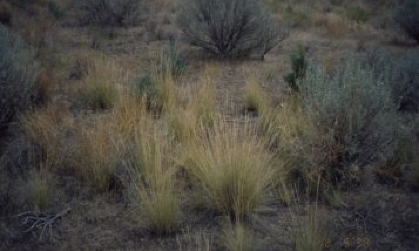
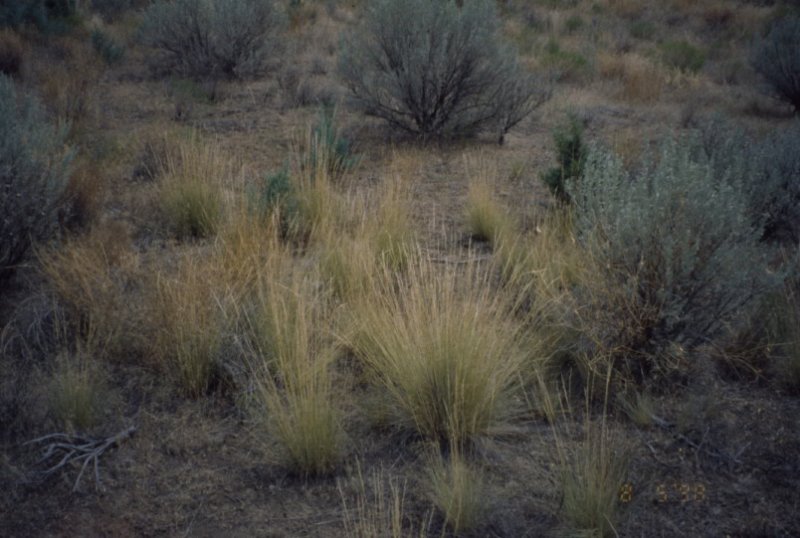
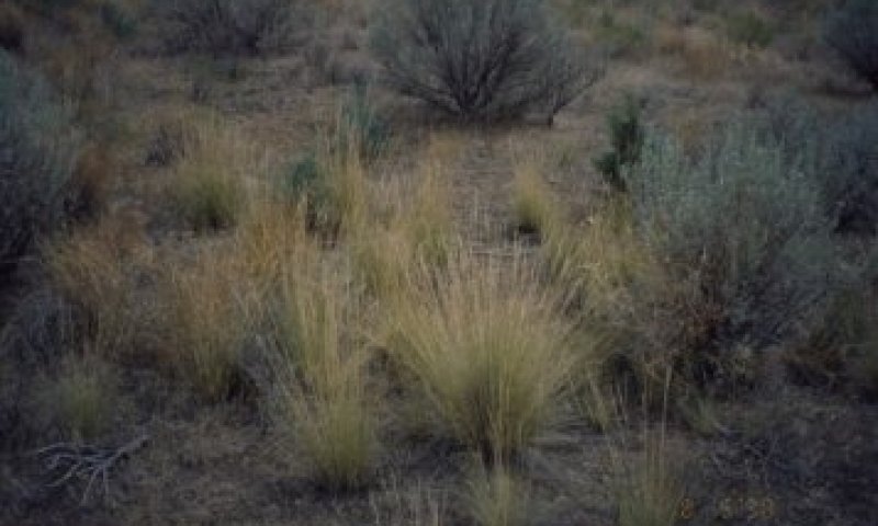
Shrub - Grass dominant community
Bunchgrasses and sagebrush dominate this site. The reference plant community consists of basin big sage and Thurber's needlegrass with bluebunch wheatgrass and some basin wildrye. Broom snakeweed, Rabbitbrush and Purple sage occur in minor amounts with sand dropseed and Indian ricegrass occurring in pockets of sandier soils. Antelope bitterbrush is found toward the higher precipitation end of this site's range. Western juniper may or may not be present.
Table 6. Annual production by plant type
| Plant type |
Low
(lb/acre) |
Representative value
(lb/acre) |
High
(lb/acre) |
| Grass/Grasslike |
1045 |
1305 |
1570 |
| Shrub/Vine |
100 |
120 |
145 |
| Forb |
55 |
75 |
85 |
| Total |
1200 |
1500 |
1800 |
| Jan |
Feb |
Mar |
Apr |
May |
Jun |
Jul |
Aug |
Sep |
Oct |
Nov |
Dec |
| J |
F |
M |
A |
M |
J |
J |
A |
S |
O |
N |
D |
Community 1.2
Bunchgrass dominant community
This community represents an early seral phase following disturbance and is dominated by perennial grasses such as Thurber's needlegrass, bluebunch wheatgrass, and great basin wildrye. Sprouting shrubs will decrease following fire but will soon increase in abundance while non-sprouting shrubs will take longer to recolonize. Western juniper will be reduced or eliminated following fire but may be returning as saplings in this community.
Community 1.3
Shrub dominant community
Following a lack of fire for an extended period, basin big sagebrush and western juniper will increase in abundance while perennial grasses will decrease.
Pathway P1.1a
Community 1.1 to 1.2
Fire occurs with enough severity to kill most of the shrub community
Pathway P1.1b
Community 1.1 to 1.3
Time and lack of disturbance, such as fire, facilitates an increase in the shrub and tree overstory.
Pathway P1.2a
Community 1.2 to 1.1
Time and lack of disturbance, such as fire, allows for regeneration of the shrub community.
Pathway P1.3a
Community 1.3 to 1.2
Fire occurs with enough severity to kill most of the shrub and tree community
State 2
Current Potential
This state is similar to the Reference State. Ecological function has not changed fundamentally, however the resiliency of the site has been reduced by the presence of invasive weeds. Additionally, livestock herbivory may be present as a disturbance process and changes in climate may be altering ecological dynamics. Non-native plant species may increase in abundance but will not become dominant or control ecological processes within this state. These species can be highly flammable and can promote fire where historically fire had been infrequent. Negative feedbacks enhance ecosystem resilience and contribute to the stability of the state. These are maintained by elements of ecosystem structure and function such as the presence of all structural and functional groups, and retention of organic matter and nutrients. Positive feedbacks driven by plant community invasion decrease ecosystem resilience and stability of the state. These include exotic plant species' high seed output, persistent seed bank, rapid growth rate, ability to cross pollinate, and adaptations for seed dispersal. Plant community phase changes are primarily driven by infrequent fire, periodic drought and ungulate herbivory.
Community 2.1
Current potential plant communities mirror those of the above Reference State 1.0 yet with the addition of a low level of invasive exotic plant invasion and influences of livestock herbivory. Livestock herbivory may result in decreases in deep rooted perennial grasses, and related increases in shallow rooted perennial grasses (such as Sandberg's bluegrass) and shrubs, among other changes.
State 3
Shrub
Within this state, site resources are primarily controlled by shrub species. Native perennial grass composition has been reduced considerably. Sprouting and non-sprouting shrubs are dominant and western juniper is often present. Exotic herbaceous species may occur.
Community 3.1
Multiple plant community phases are likely within this state, influenced by livestock herbivory and fire. Sprouting species such as rabbitbrush and broom snakeweed as well as non-sprouting species such as big sagebrush are dominant on the site. Western juniper is present. Invasive annual grasses such as cheatgrass and medusahead are likely.
State 4
Invaded
Within this state, site resources are primarily controlled by exotic annual and perennial herbaceous species. Native perennial grass composition has been greatly diminished. Shrub species and western juniper may also be present.
Community 4.1
Multiple plant communities are possible within this state, all of which are dominated by invasive annual grasses such as cheatgrass and medusahead as well as invasive annual and perennial forbs. Invader shrub species such as broom snakeweed may also be common
State 5
Tree
Within this state, site resources are primarily controlled by western juniper dominance. Native perennial grass and shrub composition have been greatly diminished and as canopy closure progresses will be further reduced. Exotic annual plant species are likely.
Community 5.1
This state may host multiple communities according to canopy cover and density of western juniper. As canopy closure progresses, cover of shrubs and perennial grasses will decrease, bare ground will increase and hydrological function will be dramatically altered.
State 6
Seeded
Within this state, site resources are primarily controlled by introduced range grasses such as crested wheatgrass (Agropyron cristatum). Multiple community phases may occur within this state and will include different compositions of native and invasive shrub and grass species and western juniper. Similar to ecological dynamics within other states of this site, shrub species and western juniper will increase with greater time since fire and herbivory pressure. While introduced range grasses may provide some analogous ecological functions to native perennial grasses, they may outcompete native grasses in the long-term.
Transition T1A
State 1 to 2
Introduction of non-native plants
Transition T2A
State 2 to 3
Chronic improperly managed grazing or prolonged time without fire sufficient enough for the perennial grass seedbank to diminish.
Transition T2B
State 2 to 4
Catastrophic fire, soil disturbing treatments or prolonged improperly managed grazing in the presence of non-native annual species.
Transition T2C
State 2 to 5
Time and lack of disturbance allows for maturation of the tree community, possibly in combination with improperly managed grazing
Restoration pathway R3A
State 3 to 2
Shrub management and seeding of native species coupled with minimal soil disturbance, potentially requiring the use of herbicide.
Context dependence. Risk of failure may be high due to droughty nature of the site and low resilience.
Transition T3A
State 3 to 4
Catastrophic fire, failed rehabilitation treatment or prolonged improperly managed grazing in the presence of annual nonnative grasses.
Transition T3B
State 3 to 5
Time and lack of disturbance allows for maturation of the tree community. May be combined with inappropriate grazing management.
Restoration pathway R3B
State 3 to 6
Shrub management and seeding species coupled with minimal soil disturbance, potentially requiring the use of herbicide.
Context dependence. Risk of failure may be high due to droughty nature of the site and low resilience.
Restoration pathway R4A
State 4 to 6
Reduction of annual grasses through herbicide use and seeding of desired species.
Context dependence. Risk of failure may be high due to droughty nature of the site and low resilience.
Restoration pathway R5B
State 5 to 3
Tree removal with minimal soil disturbance
Transition T5A
State 5 to 4
Catastrophic fire, multiple fires or failed rehabilitation attempt.
Restoration pathway R5A
State 5 to 6
Tree removal and seeding of desired species; potentially including herbicide use.
Context dependence. Risk of failure may be high due to droughty nature of the site, low resilience and potential for soil disruption from tree removal.
Transition T6A
State 6 to 3
Prolonged improperly managed grazing or lack of fire for an extended interval in the presence of a shrub component.
Transition T6B
State 6 to 4
Catastrophic fire or prolonged inappropriate grazing management in the presence of non-native annual grasses.
Transition T6C
State 6 to 5
Extended time without fire with western juniper present.