Natural Resources
Conservation Service
Ecological site R018XC105CA
Thermic Foothills
Last updated: 4/24/2024
Accessed: 12/22/2024
General information
Provisional. A provisional ecological site description has undergone quality control and quality assurance review. It contains a working state and transition model and enough information to identify the ecological site.
MLRA notes
Major Land Resource Area (MLRA): 018X–Sierra Nevada Foothills
Major Land Resource Area (MLRA) 18, Sierra Nevada Foothills is located entirely in California and runs north to south adjacent to and down-slope of the west side of the Sierra Nevada Mountains (MLRA 22A). MLRA 18 includes rolling to steep dissected hills and low mountains, with several very steep river valleys. Climate is distinctively Mediterranean (xeric soil moisture regime) with hot, dry summers, and relatively cool, wet winters. Most of the precipitation comes as rain; average annual precipitation ranges from 12 to 55 inches in most of the area (precipitation generally increases with elevation and from south to north). Geology is rather complex in this region; there were several volcanic flow and ashfall events, as well as tectonic uplift, during the past 25 million years that contributed to the current landscape.
LRU notes
LRU Description:
The Southern Sierra Foothills is defined by extensive granite (diorite, and other intrusive volcanic rocks) geology. Soil temperature regime is thermic (in most southerly and lower elevations, can be hyperthermic). Elevation ranges between about 500 and 3200 feet above sea level. Maximum elevations increase towards the southern end, where precipitation is considerably lower. Precipitation ranges from 14 to 32 inches annually. Most precipitation falls between the months of November and March in the form of rain. Mean annual air temperature ranges between 58 to 64 F. Frost free days range between 195 and 282 days. Dominant vegetation includes annual grasslands, blue oak, interior live oak, chamise (Adenostoma fasciculatum), buckbrush (Ceanothus cuneatus), and foothill pine. At the highest elevations of the LRU, canyon live oak (Quercus chrysolepis), Interior live oak, and California bay (Umbelullaria californica) can be found in the steep drainages. Chamise-yucca plant assemblages can be found on steep, south-facing slopes. Buckeye is common in the concave positions at lower elevations. Riparian trees that are generally absent from the northern LRU’s include California Sycamore (Plantanus racemosa) and lemon scented gum (Eucalyptus citriodora). Histories of livestock grazing and settlement due to mining activity have shaped the current landscape.
Classification relationships
CLASSIFICATION RELATIONSHIPS
This site is located within M261F, the Sierra Nevada Foothills Section, (McNab et al., 2007) of the National Hierarchical Framework of Ecological Units (Cleland et al., 1997), M261Fc, the Lower Granitic Foothills and M261Fd, Southern Granitic Foothills Subsections.
Level III and Level IV ecoregions systems (Omernik, 1987, and EPA, 2011) are: Level III, Central California Foothills and Coastal Mountains and Level IV, Ecoregion 6c, Southern Sierran Foothills.
Ecological site concept
This site is characterized by moderately deep to deep soils on hills. This site occurs on igneous intrusive parent materials ranging in composition from granitic to basic rocks. Slopes typically range from 5 to 60%. Precipitation typically ranges from 14 to 23 inches per year, and elevation ranges from 1150 to 2150 feet.
Soil depth and low available water capacity, typical of the lower foothill elevations where higher evapotranspiration demands exist, are the main limits to woody production. Representative moderately deep, well-drained soil components include Ahwahnee, and Vista. Ahwahnee soils form from granitic rocks and are coarse-loamy, mixed, active thermic Mollic Haploxeralfs. Vista parent material is also granitic and these soils are Coarse-loamy, mixed, superactive, thermic Typic Haploxerepts.
This ecological site consists of open blue oak (Quercus douglasii) stands (5 to 20% canopy cover) with smaller trees that rarely exceed 30 feet in height with high cover of annual forbs and grasses. Shrubs in this site are uncommon or make up a very low percentage of the site.
Associated sites
| F018XC201CA |
Thermic Granitic Foothills This site commonly occurs nearby. |
|---|
Similar sites
| R018XC104CA |
Thermic Free Face Foothills Site relationships being developed. |
|---|
Table 1. Dominant plant species
| Tree |
(1) Quercus douglasii |
|---|---|
| Shrub |
Not specified |
| Herbaceous |
(1) Avena fatua |
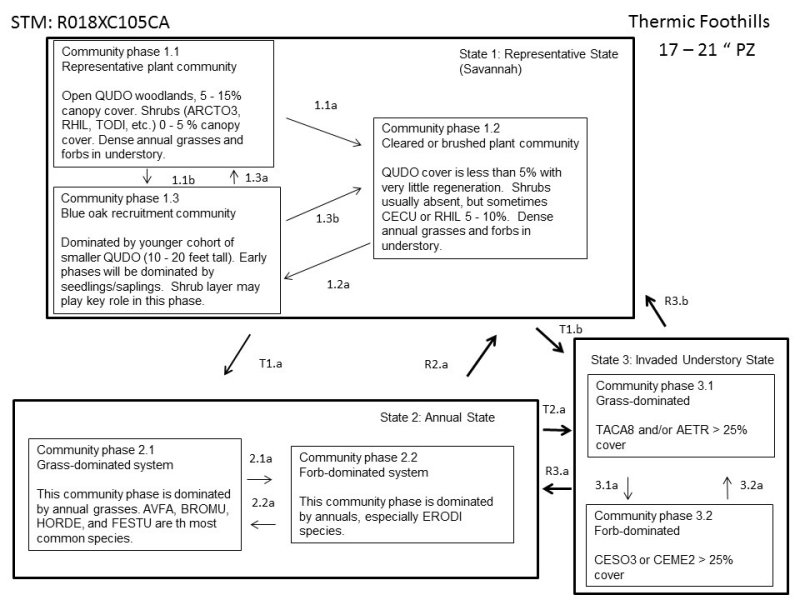
Click on box and path labels to scroll to the respective text.
Ecosystem states
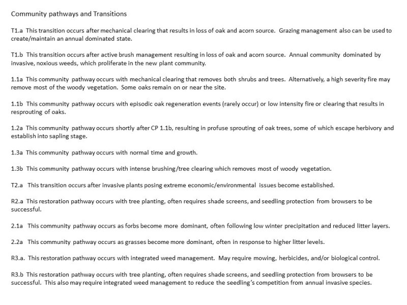
State 1 submodel, plant communities
State 2 submodel, plant communities
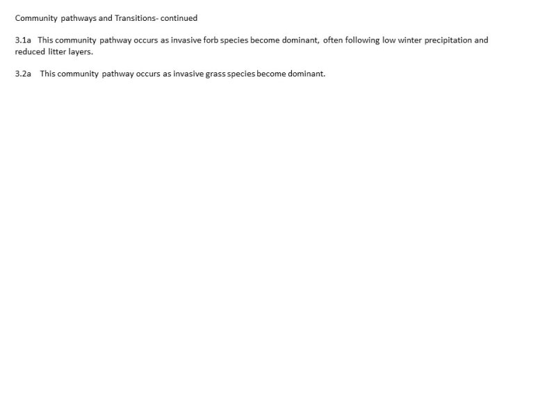
| 2.1a | - | This community pathway occurs as forbs become more dominant, often following low winter precipitation and reduced litter layers. |
|---|---|---|
| 2.2a | - | This community pathway occurs as grasses become more dominant, often in response to higher litter levels. |


