Natural Resources
Conservation Service
Ecological site R018XE104CA
Thermic Granitic Hills
Last updated: 4/24/2024
Accessed: 12/22/2024
General information
Provisional. A provisional ecological site description has undergone quality control and quality assurance review. It contains a working state and transition model and enough information to identify the ecological site.
MLRA notes
Major Land Resource Area (MLRA): 018X–Sierra Nevada Foothills
Major Land Resource Area (MLRA): 018X–Sierra Nevada Foothills
Major Land Resource Area (MLRA) 18, Sierra Nevada Foothills is located entirely in California and runs north to south adjacent to and down-slope of the Sierra Nevada Mountains (MLRA 22A). MLRA 18 includes rolling to steep dissected hills and low mountains, with several very steep river valleys. Climate is distinctively Mediterranean (xeric soil moisture regime) with hot, dry summers, and relatively cool, wet winters. Most of the precipitation comes as rain; average annual precipitation ranges from 15 to 55 inches in most of the area (precipitation generally increases with elevation and from south to north). Soil temperature regime is thermic; mean annual air temperature generally ranges between 52 and 64 degrees F. Geology is rather complex in this region; there were several volcanic flow and ashfall events, as well as tectonic uplift, during the past 25 million years that contributed to the current landscape.
LRU notes
LRU 18XE is located on moderate to steep mountains and hills in the Tehachapi Foothills east of Bakersfield. This LRU covers the lower slopes around the southern end of the Greenhorn Mountains, the western sides of Breckenridge Mountain and the Tehachapi Mountains. The elevation ranges from 500 to 6500 feet above sea level and the geology of the region is predominately granitoid (both unaltered and metamorphosed). Similar to LRU 18XC to the north, vegetation series include blue oak, needlegrass and annual grasslands, as well as chamise, ceanothus, mixed oaks, and foothill pine, although this LRU tends to be more arid than with an annual precipitation range of only 8 to 31 inches per year. The lower precipitation and higher evaporative losses mean that these soils may not be able to completely leach excess salts, leading to a build-up of calcium and/or sodium in the subsoil. The soil temperature regime in this LRU is thermic and the soil moisture regimes are both xeric and aridic.
Classification relationships
CLASSIFICATION RELATIONSHIPS
This site is located within M261F, the Sierra Nevada Foothills Section, (McNab et al., 2007) of the National Hierarchical Framework of Ecological Units (Cleland et al., 1997), M261Fb, the Lower Foothills Metamorphic Belt Subsection.
Level III and Level IV ecoregions systems (Omernik, 1987, and EPA, 2011) are: Level III, Central California Foothills and Coastal Mountains and Level IV, Ecoregion 6ae, Tehachapi Foothills.
Ecological site concept
This site is characterized by shallow to moderately deep soils occurring on hills. This site occurs on soils formed mainly in granitic and some metamorphic rocks. Slopes typically range from 5 to 60%. Precipitation typically ranges from 11 to 20 inches per year, and elevation ranges from 2366 to 4000 feet.
Deep soils at low foothill elevations where high evapotranspiration demands exist result in communities of low statured blue oaks intermingled with annual grasses and forbs. At the high end of the elevation range of this site, coarse-loamy textures and moderately deep soils with lower water storage than surrounding soils, may constrain the growth of the trees. Common soils correlated to this ecological site are Walong (Coarse-loamy, mixed, superactive, thermic Typic Haploxerolls), Arujo (Fine-loamy, mixed, superactive, thermic Pachic Argixerolls) and Feethill (Fine-loamy, mixed, superactive, thermic Typic Argixerolls).
This ecological site consists of open (5 to 20% canopy cover) blue oak (Quercus douglasii) stands of small trees that rarely exceed 30 feet in height, with high cover of annual forbs and grasses. The grass component includes wild oat (Avena fatua), soft chess (Bromus hordeaceus), ripgut brome (Bromus diandrus), red brome (Bromus madritensis ssp. Rubens), squirreltail (Elymus elymoides), annual barley (Hordeum spp.) and annual fescues (Festuca sp.). Some common forbs include fillaree (Erodium), and burclover (Medicago polymorpha). Annual production ranges from 800 to 2200 lbs per acre.
Associated sites
| R018XE103CA |
Loamy Low Hills This site commonly occurs nearby. |
|---|
Similar sites
| R018XE102CA |
Steep Clayey Shallow Site relationships being developed. |
|---|---|
| R018XE103CA |
Loamy Low Hills Site relationships being developed. |
Table 1. Dominant plant species
| Tree |
(1) Quercus douglasii |
|---|---|
| Shrub |
Not specified |
| Herbaceous |
(1) Avena fatua |
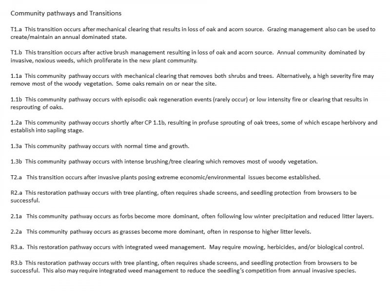
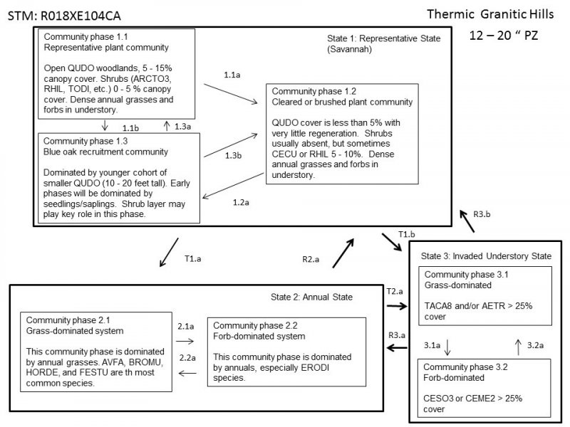
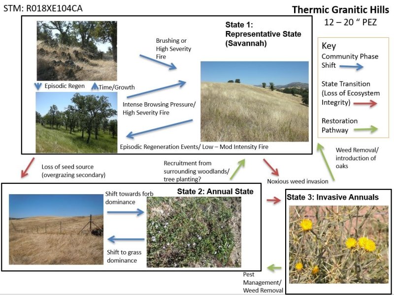
Click on box and path labels to scroll to the respective text.


