Natural Resources
Conservation Service
Ecological site R023XY013NV
DRY MEADOW
Last updated: 4/10/2025
Accessed: 04/03/2026
General information
Provisional. A provisional ecological site description has undergone quality control and quality assurance review. It contains a working state and transition model and enough information to identify the ecological site.
Ecological site concept
Currently there is only a draft of the initial concept for this ecological site. The initial concept for this site places it within the Seasonally Flooded Basin Wildrye Ecological Site Group. To view the General STM and other information available for this ESG please go to https://edit.jornada.nmsu.edu/catalogs/esg/023X/R023XY916NV
This site also occurs on floodplains and drainage ways but is also often associated with low-flow seeps and springs. It is dominated by Nevada bluegrass and forbs like yarrow (Achillea spp.), iris (Iris missouriensis), cinquefoil (Potentilla), and other mesic forbs. This site has a seasonally high water table within 20 inches of the soil surface in the spring. Soils are deep and very dark in color. This site is slightly less productive than the modal site with 1700 lb/ac in normal years. Baltic rush may increase with inappropriate grazing management. This site has a similar STM with 3 stable states.
Associated sites
| F023XY029NV |
POTR5/PONE3-CAREX-ELTR7 |
|---|---|
| F023XY034NV |
POBAT/SALIX/LEYMU |
| R023XY009NV |
LOAMY BOTTOM 8-12 P.Z. |
| R023XY025NV |
WET MEADOW 14+ P.Z. |
Similar sites
| R023XY025NV |
WET MEADOW 14+ P.Z. has full growing season water; DECE dominant grass; more productive site |
|---|
Table 1. Dominant plant species
| Tree |
Not specified |
|---|---|
| Shrub |
Not specified |
| Herbaceous |
(1) Poa nevadensis |
Physiographic features
This site occurs on floodplains, drainageways, and lake plains and is usually associated with low-flow seeps and springs. Slopes range from 0 to over 8 percent, but slope gradients of 0 to 2 percent are typical. Elevations are 4400 to 9000 feet.
Table 2. Representative physiographic features
| Landforms |
(1)
Flood plain
(2) Drainageway (3) Lake plain |
|---|---|
| Flooding duration | Very brief (4 to 48 hours) to long (7 to 30 days) |
| Flooding frequency | Rare to frequent |
| Elevation | 1,341 – 2,743 m |
| Slope | 0 – 8% |
| Water table depth | 15 – 213 cm |
| Aspect | Aspect is not a significant factor |
Climatic features
The climate associated with this site is semiarid and characterized by cold, moist winters and warm, dry summers. Average annual precipitation is 10 to over 14 inches. Mean annual air temperature is 40 to 45 degrees F. The average growing season is about 80 to 100 days.
Nevada’s climate is predominantly arid, with large daily ranges of temperature, infrequent severe storms, heavy snowfall in the higher mountains, and great location variations with elevation. Three basic geographical factors largely influence Nevada’s climate: continentality, latitude, and elevation. Continentality is the most important factor. The strong continental effect is expressed in the form of both dryness and large temperature variations. Nevada lies on the eastern, lee side of the Sierra Nevada Range, a massive mountain barrier that markedly influences the climate of the State. The prevailing winds are from the west, and as the warm moist air from the Pacific Ocean ascend the western slopes of the Sierra Range, the air cools, condensation occurs and most of the moisture falls as precipitation. As the air descends the eastern slope, it is warmed by compression, and very little precipitation occurs. The effects of this mountain barrier are felt not only in the West but throughout the state, with the result that the lowlands of Nevada are largely desert or steppes. The temperature regime is also affected by the blocking of the inland-moving maritime air. Nevada sheltered from maritime winds, has a continental climate with well-developed seasons and the terrain responds quickly to changes in solar heating.
Nevada lies within the mid-latitude belt of prevailing westerly winds which occur most of the year. These winds bring frequent changes in weather during the late fall, winter and spring months, when most of the precipitation occurs. To the south of the mid-latitude westerlies, lies a zone of high pressure in subtropical latitudes, with a center over the Pacific Ocean. In the summer, this high-pressure belt shifts northward over the latitudes of Nevada, blocking storms from the ocean. The resulting weather is mostly clear and dry during the summer and early fall, with scattered thundershowers. The eastern portion of the state receives significant summer thunderstorms generated from monsoonal moisture pushed up from the Gulf of California, known as the North American monsoon. The monsoon system peaks in August and by October the monsoon high over the Western U.S. begins to weaken and the precipitation retreats southward towards the tropics (NOAA 2004).
Average annual precipitation is 16 to over 20 inches. Mean annual air temperature is 41 to 44 degrees F. The average growing season is about 50 to 70 days.
Mean annual precipitaion at the Bear Creek, Nevada SNOTEL station (170501020301) is 37.69 inches.
monthly mean precipitation is:
January 3.84; February 3.75; March 4.38; April 4.9;
May 3.99; June 2.82; July .95; August 1.66;
September 1.22; October 2.12;
November 3.67; December 4.38.
Table 3. Representative climatic features
| Frost-free period (average) | 90 days |
|---|---|
| Freeze-free period (average) | |
| Precipitation total (average) | 305 mm |
Figure 1. Monthly precipitation range
Figure 2. Monthly average minimum and maximum temperature
Figure 3. Annual precipitation pattern
Figure 4. Annual average temperature pattern
Influencing water features
There is a seasonally high water table within 20 inches of the surface in the spring.
Soil features
The soils associated with this site are very deep, moderately well drained, and have formed in alluvium derived from pyroclastic and extrusive volcanic rocks. Permeability is slow and available water capacity is moderate to high. Clay content in the particle control sections is 40 to 60 percent. A mollic epipedon occurs from the surface to 28 inches. Vertical cracks occur on the surface to 22 inches. Typical soil series associated with this site is Grimlake, fine, smectitic, frigid Aquic Haploxererts.
Table 4. Representative soil features
| Parent material |
(1)
Alluvium
–
pyroclastic rock
|
|---|---|
| Surface texture |
(1) Cobbly clay (2) Sandy loam |
| Family particle size |
(1) Clayey |
| Drainage class | Moderately well drained |
| Permeability class | Slow |
| Soil depth | 183 – 213 cm |
| Surface fragment cover <=3" | 0 – 10% |
| Surface fragment cover >3" | 0 – 10% |
| Available water capacity (0-101.6cm) |
14.99 – 21.08 cm |
| Calcium carbonate equivalent (0-101.6cm) |
0 – 5% |
| Electrical conductivity (0-101.6cm) |
0 – 2 mmhos/cm |
| Sodium adsorption ratio (0-101.6cm) |
0 |
| Soil reaction (1:1 water) (0-101.6cm) |
6.1 – 8.4 |
| Subsurface fragment volume <=3" (Depth not specified) |
0% |
| Subsurface fragment volume >3" (Depth not specified) |
0% |
Ecological dynamics
Where management results in abusive grazing use by livestock and/or feral horses, meadow barley, rabbitsfootgrass, sedges and Baltic rush will increase in abundance, while Nevada bluegrass and palatable forbs will decrease. Misuse of this site can cause gully erosion resulting in a lowering of the water table and development of a site dominated by shrub species.
Fire Ecology:
Fire in dry meadow communities often involves stand replacing fires. The fire return interval occurs every 0 to 35 years. Nevada bluegrass is generally unharmed by fire. It produces little litter, and its small bunch size and sparse litter reduces the amount of heat transferred to perennating buds in the soil. Sedge is top-killed by fire, with rhizomes protected by insulating soil. The rhizomes of sedge species may be killed by high-severity fires that remove most of the soil organic layer. Reestablishment after fire occurs by seed establishment and/or rhizomatous spread.
State and transition model
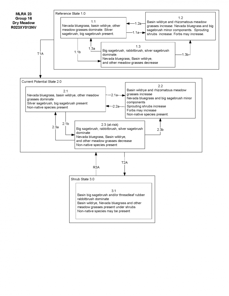
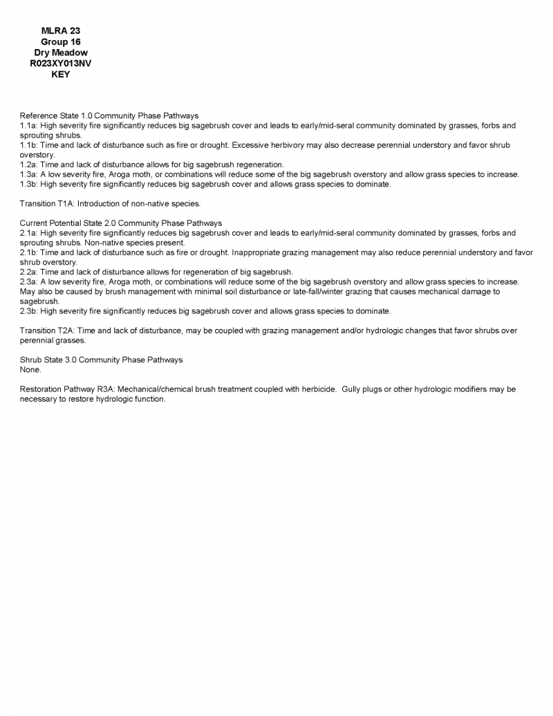
More interactive model formats are also available.
View Interactive Models
Click on state and transition labels to scroll to the respective text
Ecosystem states
State 1 submodel, plant communities
State 1
Reference Plant Community
Community 1.1
Reference Plant Community
The reference plant community is dominated by Nevada bluegrass. Potential vegetative composition is about 75% grasses, 20% forbs, and 5% shrubs. Approximate ground cover (basal and crown) is about 50 to 65 percent.
Figure 5. Annual production by plant type (representative values) or group (midpoint values)
Table 5. Annual production by plant type
| Plant type | Low (kg/hectare) |
Representative value (kg/hectare) |
High (kg/hectare) |
|---|---|---|---|
| Grass/Grasslike | 1093 | 1429 | 1849 |
| Forb | 291 | 381 | 493 |
| Shrub/Vine | 73 | 95 | 123 |
| Total | 1457 | 1905 | 2465 |
Additional community tables
Table 6. Community 1.1 plant community composition
| Group | Common name | Symbol | Scientific name | Annual production (kg/hectare) | Foliar cover (%) | |
|---|---|---|---|---|---|---|
|
Grass/Grasslike
|
||||||
| 1 | Primary Perennial Grasses/Grasslikes | 857–1239 | ||||
| sedge | CAREX | Carex | 95–286 | – | ||
| 2 | Secondary Perennial Grasses | 381–667 | ||||
| slender wheatgrass | ELTRT | Elymus trachycaulus ssp. trachycaulus | 10–95 | – | ||
| Idaho fescue | FEID | Festuca idahoensis | 10–95 | – | ||
| meadow barley | HOBR2 | Hordeum brachyantherum | 10–95 | – | ||
| basin wildrye | LECI4 | Leymus cinereus | 10–95 | – | ||
| beardless wildrye | LETR5 | Leymus triticoides | 10–95 | – | ||
| mat muhly | MURI | Muhlenbergia richardsonis | 10–95 | – | ||
| alpine timothy | PHAL2 | Phleum alpinum | 10–95 | – | ||
| annual rabbitsfoot grass | POMO5 | Polypogon monspeliensis | 10–95 | – | ||
| Kentucky bluegrass | POPR | Poa pratensis | 10–95 | – | ||
|
Forb
|
||||||
| 3 | Perennial | 286–476 | ||||
| yarrow | ACHIL | Achillea | 10–57 | – | ||
| Rocky Mountain iris | IRMI | Iris missouriensis | 10–57 | – | ||
| cinquefoil | POTEN | Potentilla | 10–57 | – | ||
| buttercup | RANUN | Ranunculus | 10–57 | – | ||
| dandelion | TARAX | Taraxacum | 10–57 | – | ||
| clover | TRIFO | Trifolium | 10–57 | – | ||
|
Shrub/Vine
|
||||||
| 4 | Primary Shrubs | 38–152 | ||||
| silver sagebrush | ARCA13 | Artemisia cana | 10–19 | – | ||
| big sagebrush | ARTR2 | Artemisia tridentata | 10–19 | – | ||
| basin big sagebrush | ARTRT | Artemisia tridentata ssp. tridentata | 10–19 | – | ||
| mountain big sagebrush | ARTRV | Artemisia tridentata ssp. vaseyana | 10–19 | – | ||
| rose | ROSA5 | Rosa | 10–19 | – | ||
| willow | SALIX | Salix | 10–19 | – | ||
Interpretations
Animal community
Livestock Interpretations:
This site is suitable for livestock grazing. Grazing management should be keyed to perennial grass production. Nevada bluegrass is a widespread forage grass. It is one of the earliest grasses in the spring and is sought by domestic livestock and several wildlife species. Nevada bluegrass is a palatable species, but its production is closely tied to weather conditions. It produces little forage in drought years, making it a less dependable food source than other perennial bunchgrasses. Sedge provides good to fair forage for domestic grazing.
Stocking rates vary over time depending upon season of use, climate variations, site, and previous and current management goals. A safe starting stocking rate is an estimated stocking rate that is fine tuned by the client by adaptive management through the year and from year to year.
Wildlife Interpretations:
Nevada bluegrass is desirable for pronghorn antelope and mule deer in the spring and preferable in the spring, summer, and fall for elk and desirable as part of their winter range. Sedges have a high to moderate resource value for elk and a medium value for mule deer. Elk consume beaked sedge later in the growing season.
Hydrological functions
Runoff is medium to very high. Permeability is slow to moderately slow. Rills are none. Water flow patterns are none. Pedestals are none. Gullies are none. Deep-rooted perennial grasses and/or rhizomatous grasses slow runoff and increase infiltration. Shrub canopy and associated litter break raindrop impact and provide opportunity for snow catch and moisture accumulation on site.
Recreational uses
Aesthetic value is derived from the diverse floral and faunal composition and the colorful flowering of wild flowers and shrubs during the spring and early summer. This site offers rewarding opportunities to photographers and for nature study. This site is used for camping and hiking and has potential for upland and big game hunting.
Supporting information
Type locality
| Location 1: Washoe County, NV | |
|---|---|
| Township/Range/Section | T16N R19E S3 |
| UTM zone | N |
| UTM northing | 264502 |
| UTM easting | 4646720 |
| Latitude | 41° 56′ 14″ |
| Longitude | 119° 50′ 26″ |
| General legal description | SE 1/4 NW 1/4, Bally Mountain area, Washoe County, Nevada. This site also occurs in Humboldt County, Nevada. |
| Location 2: Washoe County, NV | |
| Township/Range/Section | T39N R19E S5 |
| UTM zone | N |
| UTM northing | 259349 |
| UTM easting | 4575309 |
| Latitude | 41° 17′ 36″ |
| Longitude | 119° 52′ 26″ |
| General legal description | Stringer meadows northeast of Hays Canyon Peak, Washoe County, Nevada. This site also occurs in Humboldt County, Nevada. |
Other references
Fire Effects Information System (Online; http://www.fs.fed.us/database/feis/plants/).
USDA-NRCS Plants Database (Online; http://www.plants.usda.gov).
Great Basin Ecological Site Development Project: State and Transition Models for Major Land Resource Area 23, Nevada and portions of California (Online; https://naes.agnt.unr.edu/PMS/Pubs/2019-4060.pdf)
Contributors
BH/SW
T Stringham (UNR under contract with BLM)
Rangeland health reference sheet
Interpreting Indicators of Rangeland Health is a qualitative assessment protocol used to determine ecosystem condition based on benchmark characteristics described in the Reference Sheet. A suite of 17 (or more) indicators are typically considered in an assessment. The ecological site(s) representative of an assessment location must be known prior to applying the protocol and must be verified based on soils and climate. Current plant community cannot be used to identify the ecological site.
| Author(s)/participant(s) | Patti Novak-Echenique |
|---|---|
| Contact for lead author | State Rangeland Management Specialist |
| Date | 05/14/2010 |
| Approved by | Kendra Moseley |
| Approval date | |
| Composition (Indicators 10 and 12) based on | Annual Production |
Indicators
-
Number and extent of rills:
None -
Presence of water flow patterns:
A few waterflow patterns will occur after recent flooding events. -
Number and height of erosional pedestals or terracettes:
None -
Bare ground from Ecological Site Description or other studies (rock, litter, lichen, moss, plant canopy are not bare ground):
Bare Ground ± 10-20%. -
Number of gullies and erosion associated with gullies:
None -
Extent of wind scoured, blowouts and/or depositional areas:
None -
Amount of litter movement (describe size and distance expected to travel):
Fine litter (foliage of grasses and annual & perennial forbs) only expected to move during periods of flooding by adjacent streams. Persistent litter (large woody material) will remain in place except during major flooding events. -
Soil surface (top few mm) resistance to erosion (stability values are averages - most sites will show a range of values):
Soil stability values will range from 3 to 6. (To be field tested.) -
Soil surface structure and SOM content (include type of structure and A-horizon color and thickness):
Structure of soil surface is medium prismatic. Soil surface colors are dark grays and soils are typified by a mollic epipedon. Organic matter in the surface horizon will range from 1 to 3 percent. -
Effect of community phase composition (relative proportion of different functional groups) and spatial distribution on infiltration and runoff:
Deep-rooted perennial grasses and/or rhizomatous grasses slow runoff and increase infiltration. Shrub canopy and associated litter break raindrop impact and provide opportunity for snow catch and moisture accumulation on site. -
Presence and thickness of compaction layer (usually none; describe soil profile features which may be mistaken for compaction on this site):
Compacted layers are none. Subangular blocky or prismatic layers are normal for this site and are not to be interpreted as compaction -
Functional/Structural Groups (list in order of descending dominance by above-ground annual-production or live foliar cover using symbols: >>, >, = to indicate much greater than, greater than, and equal to):
Dominant:
Tall-statured, deep-rooted, cool season, perennial bunchgrasses > short-statured rhizomatous grasses > associated perennial grasses and grass-like plantsSub-dominant:
deep-rooted, cool season, perennial forbs = fibrous, shallow-rooted, cool season, perennial and annual forbs > tall shrubsOther:
Additional:
-
Amount of plant mortality and decadence (include which functional groups are expected to show mortality or decadence):
Some mortality will occur in the centers of perennial bunchgrasses. -
Average percent litter cover (%) and depth ( in):
Under canopy and within plant interspaces up to 70% and depth of litter ± ½ inch. -
Expected annual annual-production (this is TOTAL above-ground annual-production, not just forage annual-production):
For normal or average growing season (through end of May) ± 1700 lbs/ac; Favorable years ± 2200 lbs/ac, Unfavorable years ±1300 lbs/ac -
Potential invasive (including noxious) species (native and non-native). List species which BOTH characterize degraded states and have the potential to become a dominant or co-dominant species on the ecological site if their future establishment and growth is not actively controlled by management interventions. Species that become dominant for only one to several years (e.g., short-term response to drought or wildfire) are not invasive plants. Note that unlike other indicators, we are describing what is NOT expected in the reference state for the ecological site:
Potential invaders include annual mustards, annual kochia, pigweed, and perennial pepperweed. -
Perennial plant reproductive capability:
All functional groups should reproduce in average (or normal) and above average growing season years.
Print Options
Sections
Font
Other
The Ecosystem Dynamics Interpretive Tool is an information system framework developed by the USDA-ARS Jornada Experimental Range, USDA Natural Resources Conservation Service, and New Mexico State University.
Click on box and path labels to scroll to the respective text.