
Natural Resources
Conservation Service
Ecological site R023XY200OR
PONDED CLAY
Accessed: 02/07/2026
General information
Provisional. A provisional ecological site description has undergone quality control and quality assurance review. It contains a working state and transition model and enough information to identify the ecological site.
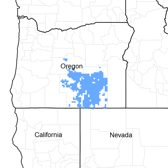
Figure 1. Mapped extent
Areas shown in blue indicate the maximum mapped extent of this ecological site. Other ecological sites likely occur within the highlighted areas. It is also possible for this ecological site to occur outside of highlighted areas if detailed soil survey has not been completed or recently updated.
Associated sites
| R023XY212OR |
LOAMY 10-12 PZ Loamy 10-12 PZ (shallow to moderately deep loamy upland site, different composition- ARTRW8/ACTH7-PSSPS association) |
|---|---|
| R023XY214OR |
CLAYPAN 10-12 PZ Claypan 10-12 PZ (very shallow to a restrictive layer upland site, different composition- ARAR8/PSSPS-POSE association) |
| R023XY220OR |
CLAYEY 10-12 PZ Clayey 10-12 PZ (shallow to moderately deep clayey upland site, different composition- ARTRW8/PSSPS association) |
| R023XY316OR |
DROUGHTY LOAM 11-13 PZ Droughty Loam 11-13 PZ (shallow to moderately deep loamy upland site, different composition- ARTRT-V/FEID-ACTH7 association) |
Similar sites
| R023XY100OR |
LAKEBED Lakebed (frequent ponding to greater depth and longer duration - 2 feet 3 in 10 years, different composition-ELEOC/RUMEX/JUARL association, ARCA13 absent) |
|---|---|
| R024XY007OR |
DRY PONDED CLAY 6-10 PZ Dry Ponded Clay 6-10 PZ (drier, flooding and ponding rare, lower production, different composition- ARTRT/LETR5 association) |
| R024XY125OR |
SEMI PONDED LAKEBED Semi Ponded Lakebed (shorter annual ponding duration with infrequent long deep ponding, different composition- MURI-PONE3(POSE) association, ARCA13 absent) |
| R024XY126OR |
FLOODED CLAY SWALE Flooded Clay Swale (swale and overflow channel position, variable annual flooding, not ponded, higher production) |
Table 1. Dominant plant species
| Tree |
Not specified |
|---|---|
| Shrub |
(1) Artemisia cana ssp. bolanderi |
| Herbaceous |
(1) Poa nevadensis |
Physiographic features
This site typically occurs in small playas and depressional areas located on uplands and plateaus. They are subject to annual spring ponding events. The depth and duration of ponding is dependent on the extent of runoff, rain and snow events on frozen soil, the size of the watershed and cyclical weather patterns. Slopes typically range from 0 to 2%. Elevations vary from 4,500 to 6,000 feet.
Table 2. Representative physiographic features
| Landforms |
(1)
Depression
(2) Plateau |
|---|---|
| Ponding duration | Brief (2 to 7 days) to very brief (4 to 48 hours) |
| Ponding frequency | Frequent to occasional |
| Elevation | 4,500 – 6,000 ft |
| Slope | 2% |
| Aspect | Aspect is not a significant factor |
Climatic features
The annual precipitation ranges from 10 to 12 inches, most of which occurs in the form of snow and rain during the months of December through April. A seasonal supply of ponded and subsurface moisture augments the precipitation. The soil temperature regime is frigid with a mean air temperature of 45 degrees F. Temperature extremes range from 100 to -20 degrees F. The frost-free period ranges from less than 60 to 90 days. The optimum growth period for plant growth is from mid April to early July.
Table 3. Representative climatic features
| Frost-free period (average) | 90 days |
|---|---|
| Freeze-free period (average) | 0 days |
| Precipitation total (average) | 12 in |
Influencing water features
Soil features
The soils of this site are typically fine textured, deep and somewhat poorly to poorly drained. The surface layer is a typically a silty clay loam over a clay subsoil often with a pick-up of loams to very gravelly loams at greater depths. Substratums are old lake terrace lacustrine sediments or basalt and rhyolitic bedrock. Variable duration ponding in the depressions occurs in the spring. Permeability is slow to very slow. The available water holding capacity (AWC) is about 6 to 10 inches for the profile. A seasonal high water table is present in the spring. The water erosion potential is slight due to the depositional position of the site.
Table 4. Representative soil features
| Parent material |
(1)
Lacustrine deposits
–
rhyolite
|
|---|---|
| Surface texture |
(1) Silty clay loam (2) Clay loam |
| Family particle size |
(1) Clayey |
| Drainage class | Somewhat poorly drained to poorly drained |
| Permeability class | Slow to very slow |
| Soil depth | 40 – 72 in |
| Available water capacity (0-40in) |
6 – 10 in |
Ecological dynamics
The potential native plant community is dominated by Nevada bluegrass and silver sagebrush (Bolander). Beardless (creeping) wildrye is prominent. Sedges, rushes, bottlebrush squirrreltail, Sandberg and a variety of forbs are present. Vegetative composition of the community is approximately 85 percent grasses, 5 percent forbs and 10 percent shrubs. The approximate ground cover is 60 to 80 percent (basal and crown).
Range in Characteristics:
Variability in plant composition and production on this site results from differences in the duration of annual ponding events and related sub-surface water availability. Production increases with increasing available surface and subsurface moisture. Nevada bluegrass increases at the upper end of the precipitation zone were ponding duration is longer. Beardless wildrye increases in drier areas. Concentric vegetation patterns develop in depressional playas based on the extent and duration of ponding. With longer duration ponding sedges and rushes increase in the center and silver sagebrush decreases. Nevada bluegrass typically occurs throughout the playa except where extended deep ponding occurs. Mat muhly and Douglas’ sedge increase in drier areas. Sandberg bluegrass and associated upland vegetation occur on the outer dry playa edges.
Response to Disturbance - States:
Deterioration of the site can result from both hydrologic alterations and overgrazing. Limited hydrologic alterations occur on playa sites with the construction of dugouts to concentrate water for extended seasonal livestock water. The concentration of water reduces the extent and depth of water on the remaining site with variable loss of wetland plants. The changes are most apparent at the lower end of the precipitation zone where limited runoff is available for ponding.
When the condition of the site deteriorates as a result of over grazing, Nevada bluegrass decreases. Silver sage, creeping wild rye and a variety of forbs increase. Under deteriorated conditions bare ground rapidly increases. Production decreases and silver sage strongly dominates the site. Upland vegetation including big sagebrush, beardless wildrye and Sandberg bluegrass increases on the drier site edges. Soil surface structural changes are apparent. There is a reduction in organic matter, an increase in dry season surface plateness and a decrease in intake rates.
States: ARCAB3/bare ground; playa; altered land use changes
State and transition model
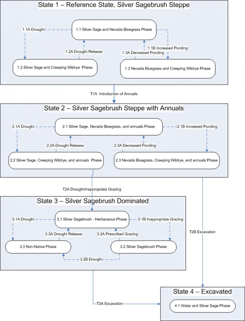
More interactive model formats are also available.
View Interactive Models
More interactive model formats are also available.
View Interactive Models
Click on state and transition labels to scroll to the respective text
State 1 submodel, plant communities
State 3 submodel, plant communities
State 4 submodel, plant communities
State 1
Reference State
Community 1.1
Reference Plant Community
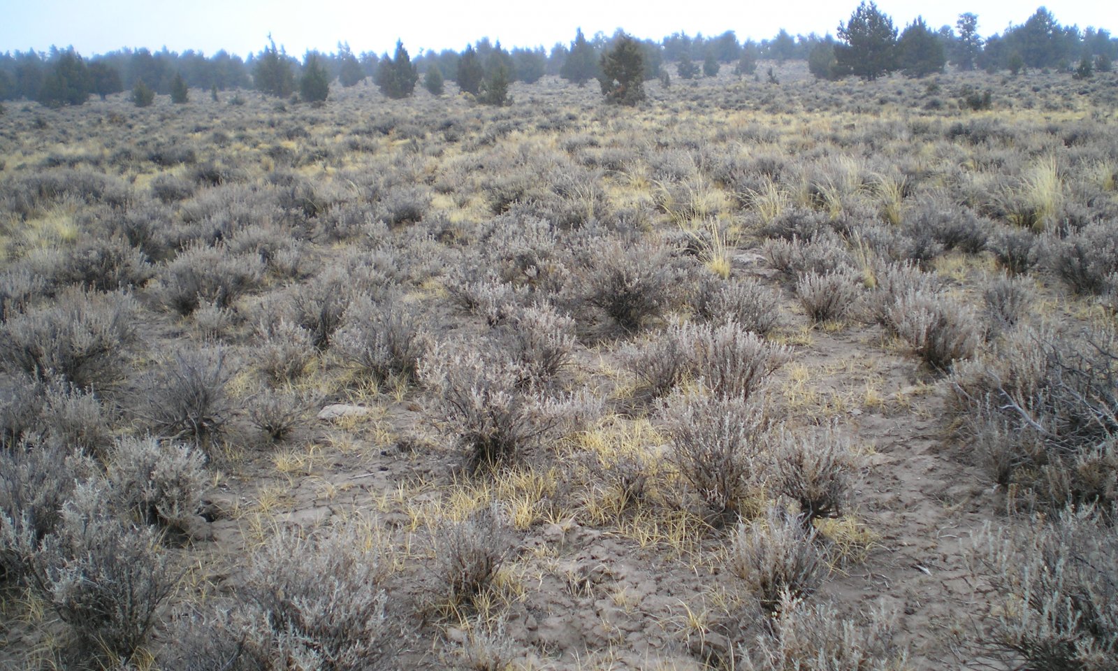
The reference native plant community is dominated by Nevada bluegrass and silver sagebrush (Bolander). Beardless (creeping) wildrye is prominent. Sedges, rushes, bottlebrush squirrreltail, Sandberg and a variety of forbs are present. Vegetative composition of the community is approximately 80 percent grasses, 5 percent forbs and 15 percent shrubs. The approximate ground cover is 60 to 80 percent (basal and crown).
Figure 2. Annual production by plant type (representative values) or group (midpoint values)
Table 5. Annual production by plant type
| Plant type | Low (lb/acre) |
Representative value (lb/acre) |
High (lb/acre) |
|---|---|---|---|
| Grass/Grasslike | 480 | 800 | 1200 |
| Shrub/Vine | 90 | 150 | 225 |
| Forb | 30 | 50 | 75 |
| Total | 600 | 1000 | 1500 |
Community 1.2
Silver Sage and Creeping Wildrye
Community phase 1.2 is a grass/grasslike dominated plant community with an increase of silver sagebrush in the overstory and creeping wildrye in the understory. Nevada bluegrass, creeping wildrye, dryland sedges and other perennial grasses are the major grasses/grasslikes.
Community 1.3
Nevada Bluegrass and Creeping Wildrye
1.3 is a grass-dominated community with a decrease of silver sagebrush in the overstory, an increase of Nevada bluegrass in the grass/grasslike community, and an increase in forbs. Nevada bluegrass, creeping wildrye, dryland sedges and other perennial grasses are the major grasses/grasslikes. Prolonged wet conditions during the growing season result in increased floristic expression of annual forbs. Multiple wet years may result in the establishment of more perennial forbs. During wet years, ponding exceeds the duration that silver sagebrush can withstand, causing large-scale silver sagebrush mortality. Small patches of silver sagebrush remain on microtopographical high spots throughout the site and around the edges of the site where ponding duration is the shortest.
Pathway 1.1 A
Community 1.1 to 1.2
Long-term drought favors silver sagebrush and rhizomatous species such as creeping wildrye. Bunchgrass density may decline under prolonged drought; resulting in Phase 1.2.
Pathway 1.1B
Community 1.1 to 1.3
Multiple wet years may reduce sagebrush and increase production of bunchgrasses; resulting in Phase 1.3.
State 2
Silver Sagebrush steppe with annuals
State 2 mimics State 1 with the addition of non-native species (e.g. cheatgrass, bur buttercup,clasping pepperweed and whitetop) being present. Presence of these species reduces the site’s resistance and resiliency to disturbance and slightly alters function by altering the site’s resource availability and shifting it slightly towards the non-native species. Many non-native species are more well-adapted to extract site resources than native species by being prolific seed producers, shallow-rooted to extract water quickly when water is limiting in drought years, and through rapid uptake of available nutrients in the soils. When a disturbance does occur, the non-native species will also respond more rapidly to the disturbance further impacting the site’s resiliency and resistance. Feedback mechanisms: Herbaceous cover provides organic matter to the soil preventing vesicular crust formation which promotes infiltration and seedling establishment. Annual ponding prevents conversion to upland vegetation.
Community 2.1
Silver Sage Steppe with Annuals
Similar to reference community phase 1.1 and is dominated by Nevada bluegrass, creeping wildrye, and silver sagebrush. Significant amounts of dryland sedges, mat muhly, rushes, bottlebrush squirreltail, bluegrasses, and forbs also occur on this site. Non-native species are present in this phase.
Community 2.2
Silver Sage and Creeping Wildrye with non-natives
This is an “at-risk” community for State 2, and similar to reference community phase 1.2. Drier conditions in this phase and reduced resiliency due to the presence of non-native species make this phase sensitive to disturbance and more suitable for the more opportunistic non-native species to begin to increase on site. This community is “at-risk” of transitioning into State 3.
Community 2.3
Nevada Bluegrass and Creeping Wildrye w/ Non-natives
Prolonged drought and heavy disturbance, such as continuous heavy grazing by animals that exceeds the plant community’s ability to recover, favors silver sagebrush and creeping wildrye over bunchgrasses and encourages native increasers (e.g. povertyweed and evening primrose) and non-native species.
Pathway 2.1A
Community 2.1 to 2.2
Long-term drought favors silver sagebrush and rhizomatous species such as creeping wildrye. Bunchgrass density may decline under prolonged drought; resulting in Phase 2.2. Non-native species stable to increasing.
Pathway 2.1B
Community 2.1 to 2.3
Multiple wet years may reduce silver sagebrush and increase production of bunchgrasses; resulting in phase 2.3. Non-native species present.
State 3
Silver Sagebrush dominated
State 3 has three community phases depending on the amount (percent composition by weight) of silver sagebrush in relation with perennial grasses/grasslikes, native increaser forbs, and non-native species. As disturbance increases, native perennial grasses/grasslikes and forbs decrease while silver sagebrush increases. Non-natives (e.g. cheatgrass, bur buttercup, clasping pepperweed and whitetop) and native increaser forbs (e.g. povertyweed and evening primrose) are common. If disturbance is continuous and/or repeatedly impacts the plants during the critical growing season, silver sagebrush declines and non-native species increase. Ecological functional groups described in State 1 are still present in this state, however the production and resiliency of the state has been reduced by the presence of non-native species and a thick silver sagebrush overstory. Feedback mechanisms: Reduced organic matter inputs into the soil increase the prevalence of vesicular crusts which slow infiltration, increasing water loss to evaporation, and inhibit seedling establishment. Silver sagebrush dominates the site reducing availability of light and nutrients to other species on the site.
Community 3.1
Silver Sagebrush-Herbaceous Phase

Figure 3. Community Phase 3.1
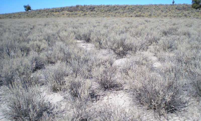
Figure 4. Community Phase 3.
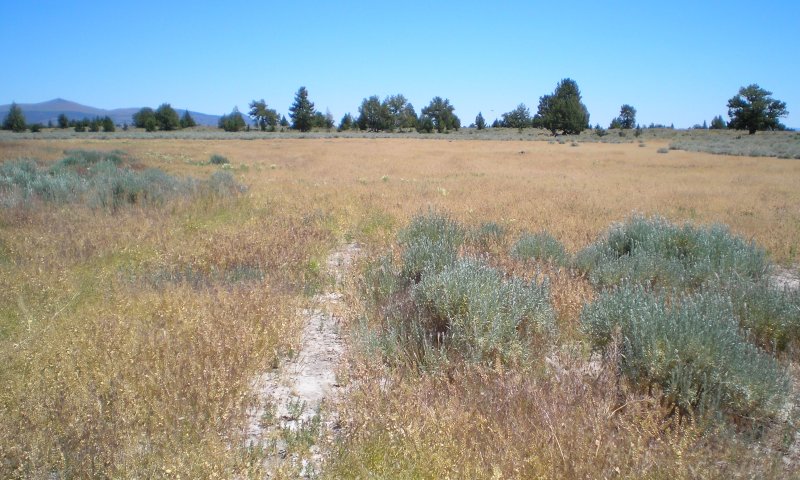
Figure 5. Community Phase 3.3
Community phase 3.1 is dominated by a silver sagebrush overstory. Nevada bluegrass and creeping wildrye are present in the understory, but at reduced amounts compared to the reference community. Dryland sedges, mat muhly, rushes, bottlebrush squirreltail, bluegrasses, and forbs also occur on this site, but in reduced amounts compared to the reference community. Native increasers (e.g. povertyweed and evening primrose) have increased, and are now common throughout the site. Non-natives on site are stable to increasing. Bare ground is high and vesicular crusts are becoming more prevalent on site.
Figure 6. Annual production by plant type (representative values) or group (midpoint values)
Community 3.2
Silver Sagebrush Phase
Community phase 3.2 is dominated by a silver sagebrush overstory. Silver sagebrush has increased to maximum capability of the community for this state. The native grasses/grasslikes are only present in trace amounts in this phase and are in jeopardy of being removed from the site. Bare ground and vesicular crusts are very high. Native increaser forbs and non-native species range from present in small amounts to common in the understory.
Community 3.3
Non-native Phase
Community phase 3.3 is dominated by non-native species. Native species are only present in trace amounts in this phase and are in jeopardy of being removed from the site. Repeated disturbance has hindered the ability of silver sagebrush to resprout causing mortality of the sagebrush overstory. Non-native species are able to respond quickly to disturbance and utilize site resources released by the silver sagebrush, and increase on site.
Pathway 3.1B
Community 3.1 to 3.2
Continuous heavy grazing by animals that exceeds the plant community’s ability to recover, increased fire frequency, and/or long-term drought favor silver sagebrush; leads to a decline in all grasses, an increase in silver sagebrush, and an increase in native increasers and non-native species; resulting in phase 3.2.
Pathway 3.1A
Community 3.1 to 3.3
Disturbance is continuous and/or repeatedly impacts the plants during the critical growing season (e.g. increased fire frequency or continuous heavy grazing by animals that exceeds the plant community’s ability to recover) causing mortality of native species. As silver sagebrush declines non-native species increase due to their ability to quickly respond to disturbance and utilize site resources released by the native species; resulting in phase 3.3.
Pathway 3.2A
Community 3.2 to 3.1
Grazing that does not inhibit the plant community’s ability to recover, reduced fire frequency, and/or multiple wet years or herbivory by insects reduce silver sagebrush and increase production of grass plants; resulting in phase 3.1.
Pathway 3.2B
Community 3.2 to 3.3
Disturbance is continuous and/or repeatedly impacts the plants during the critical growing season (e.g. increased fire frequency or continuous heavy grazing by animals that exceeds the plant community’s ability to recover) causing mortality of native species. As silver sagebrush declines non-native species increase due to their ability to quickly respond to disturbance and utilize site resources released by the native species; resulting in phase 3.3.
Pathway 3.3A
Community 3.3 to 3.1
Removal of disturbance that is continuous and/or repeatedly impacts the plants during the critical growing season (e.g. decreased fire frequency and/or prescribed grazing by animals) in combination with multiple wet years allows remnant native species to recover and allows for limited seedling establishment when not inhibited by vesicular crusts; resulting in phase 3.1.
State 4
Excavated
State 4 has been hydrologically-altered through the excavation of a water hole (dug-out) in the center of the site causing it to cross an abiotic threshold. The altered hydrology of the site is controlling vegetative composition. Water holes concentrate ponded water in the center of the site, reducing the extent and duration of ponding across the site. This causes a moisture gradient change on the site which alters the vegetative composition. Hydrologic conditions on the perimeter of the site are drier than can support the species composition of the Ponded Clay ecological site. Due to concentration of water into the water hole, the perimeter of the site no longer ponds, allowing it to convert to upland vegetation. The portion of the site rmaining in the Ponded Clay ecological site will have a similar plant composition to any of the phases in the previous states. These water holes concentrate livestock and wildlife in the area which can lead to impacts including continuous heavy grazing by animals that exceeds the plant community's ability to recover, soil compaction when soils are wet, and trampling of plants. Concentrated use by livestock and wildlife favors silver sagebrush and generally causes a reduction of perennial grasses. This impact may be reduced by providing off-site water away from this water hole. Degree of upland vegetation encroachment is influenced by climatic conditions and the size of the water hole. If available water for ponding exceeds the capacity of the water hole, the area around the water hole will pond, simulating natural conditions and facilitating growth of vegetation as described in the reference community or wet phases described in the model. Sites with smaller capacity water holes or large playas where the water hole constitutes a small fraction of the playa's total capacity are also more likely to have ponding outside of the water hole. During wet climatic cycles, available water is more likely to exceed water hole capacity.
Community 4.1
Water and Silver Sage Phase
Community phases found with State 5 can be any of the phases in States 1-3 based on what phase existed prior to excavating the water hole and management of the site; however, the extent of the site is reduced due to the concentration of water in the water hole. The site will follow the same pathways described in States 1-3. Drier conditions as a result of the water hole may emulate long-term drought in other portions of the model.
Transition T1A
State 1 to 2
Introduction of non-native species (e.g. cheatgrass, bur buttercup, clasping pepperweed and whitetop) reduces the site's resiliency to disturbance.
Transition T2A
State 2 to 3
Prolonged drought and heavy disturbance, such as continuous heavy grazing by animals that exceeds the plant community's ability to recover, favors silver sagebrush and creeping wildrye over bunchgrasses and encourages native increasers (e.g. povertyweed and evening primrose) and non-native species. Silver sagebrush dominates the site and creates a denser canopy that reduces availability of light and nutrients to other species on the site and favors the native increasers and non-natives. This reduces ecological resiliency of the site and a biotic threshold is crossed. As perennial bunchgrass composition decreases and silver sagebrush increases, vesicular crusts also become more common on the soil surface due to reduced organic matter inputs. Vesicular crusts slow infiltration, increasing water loss to evaporation and inhibit seedling establishment of native forbs and grasses, further facilitating the dominance of the native increasers and the non-native species.
Transition T2B
State 2 to 4
Excavation of a water hole (dug-out) in the center of the site alters the hydrologic function of the site causing it to cross an abiotic threshold.
Transition T3A
State 3 to 4
Excavation of a water hole (dug-out) in the center of the site alters the hydrologic function of the site causing it to cross an abiotic threshold.
Additional community tables
Table 6. Community 1.1 plant community composition
| Group | Common name | Symbol | Scientific name | Annual production (lb/acre) | Foliar cover (%) | |
|---|---|---|---|---|---|---|
|
Grass/Grasslike
|
||||||
| 1 | Dominant, perennial, moderate-rooted bunchgrass | 400–600 | ||||
| 2 | Sub-dominant, moderate rooted, rhizomatous grass | 20–50 | ||||
| beardless wildrye | LETR5 | Leymus triticoides | 20–50 | – | ||
| 3 | Perennial, moderate rooted, grass/grass-like | 100–200 | ||||
| sedge | CAREX | Carex | 50–100 | – | ||
| mat muhly | MURI | Muhlenbergia richardsonis | 50–100 | – | ||
| 4 | Other perennial grass/grass-like | 70–170 | ||||
| squirreltail | ELEL5 | Elymus elymoides | 20–70 | – | ||
| meadow barley | HOBR2 | Hordeum brachyantherum | 0–50 | – | ||
| rush | JUNCU | Juncus | 10–50 | – | ||
| basin wildrye | LECI4 | Leymus cinereus | 0–50 | – | ||
| Sandberg bluegrass | POSE | Poa secunda | 5–30 | – | ||
| Douglas' sedge | CADO2 | Carex douglasii | 5–30 | – | ||
|
Forb
|
||||||
| 5 | Perennial forbs | 20–80 | ||||
| povertyweed | IVAX | Iva axillaris | 5–20 | – | ||
| desertparsley | LOMAT | Lomatium | 5–20 | – | ||
| lupine | LUPIN | Lupinus | 5–20 | – | ||
| evening primrose | OENOT | Oenothera | 3–10 | – | ||
| figwort | SCROP | Scrophularia | 0–10 | – | ||
|
Shrub/Vine
|
||||||
| 6 | Dominant, deciduous, sprouting shrub | 150–200 | ||||
| silver sagebrush | ARCAB3 | Artemisia cana ssp. bolanderi | 150–200 | – | ||
| 7 | Other shrub | 0–30 | ||||
| Wyoming big sagebrush | ARTRW8 | Artemisia tridentata ssp. wyomingensis | 0–30 | – | ||
Table 7. Community 1.3 plant community composition
| Group | Common name | Symbol | Scientific name | Annual production (lb/acre) | Foliar cover (%) |
|---|
Table 8. Community 3.1 plant community composition
| Group | Common name | Symbol | Scientific name | Annual production (lb/acre) | Foliar cover (%) | |
|---|---|---|---|---|---|---|
|
Grass/Grasslike
|
||||||
| 1 | Dominant, perennial, moderate-rooted bunchgrass | 10–25 | ||||
| 2 | Sub-dominant, moderate rooted, rhizomatous grass | 10–25 | ||||
| beardless wildrye | LETR5 | Leymus triticoides | 10–25 | – | ||
| 3 | Perennial, moderate rooted, grass/grass-like | 60–125 | ||||
| sedge | CAREX | Carex | 25–50 | – | ||
| squirreltail | ELEL5 | Elymus elymoides | 25–50 | – | ||
| mat muhly | MURI | Muhlenbergia richardsonis | 10–25 | – | ||
| 4 | Other perennial grass/grass-like | 5–25 | ||||
| rush | JUNCU | Juncus | 5–10 | – | ||
|
Forb
|
||||||
| 5 | Perennial forbs | 30–50 | ||||
| evening primrose | OENOT | Oenothera | 5–25 | – | ||
| povertyweed | IVAX | Iva axillaris | 0–5 | – | ||
| desertparsley | LOMAT | Lomatium | 0–5 | – | ||
| lupine | LUPIN | Lupinus | 0–5 | – | ||
|
Shrub/Vine
|
||||||
| 6 | Dominant, deciduous, sprouting shrub | 250–350 | ||||
| silver sagebrush | ARCAB3 | Artemisia cana ssp. bolanderi | 250–350 | – | ||
Interpretations
Animal community
Livestock Grazing:
This site can easily be damaged if grazed when the soils are wet. It is well suited for livestock grazing use in the summer and fall under a planned grazing system. Use should be postponed until the soils are firm enough to prevent trampling damage and soil compaction. Grazing management should be keyed for Nevada bluegrass. Nevada bluegrass can be severely damaged if heavily grazed during periods of grass seed formation before root reserves have accumulated and soil moisture is low. Deferred grazing or rest is recommended at least once every three years.
Wildlife
This site is used by pronghorn antelope, mule deer, rabbits, rodents, sage grouse and other upland birds, waterfowl and various predators. It provides excellent spring forage, rearing food and water for a large variety of wildlife.
Hydrological functions
The soils of this site are typically in a depressional topographic position, accumulate off-site surface flows and have no runoff potential. When vegetation cover is high they have improved soil surface characteristics and optimized inherently low infiltration rates. Hydrologic cover is high when the composition of Nevada and other perennial dominant understory grasses, is greater than 70 percent of potential. The soils are in hydrologic group D.
Other information
This site presently has limited potential for native reseeding due to the present unavailability of Nevada bluegrass seed.
Supporting information
Contributors
A V Bahn
Bob Gillaspy
M. Parks (OSU)
NRCS/BLM Team
NRCS/BLM Team - Redmond (Up-date)
SCS/BLM Teams - Hines (1988 & 1994)
Rangeland health reference sheet
Interpreting Indicators of Rangeland Health is a qualitative assessment protocol used to determine ecosystem condition based on benchmark characteristics described in the Reference Sheet. A suite of 17 (or more) indicators are typically considered in an assessment. The ecological site(s) representative of an assessment location must be known prior to applying the protocol and must be verified based on soils and climate. Current plant community cannot be used to identify the ecological site.
| Author(s)/participant(s) | Jeff Repp |
|---|---|
| Contact for lead author | Oregon NRCS State Rangeland Management Specialist |
| Date | 08/09/2012 |
| Approved by | Bob Gillaspy |
| Approval date | |
| Composition (Indicators 10 and 12) based on | Annual Production |
Indicators
-
Number and extent of rills:
None, slight sheet & rill erosion hazard -
Presence of water flow patterns:
None -
Number and height of erosional pedestals or terracettes:
None to very few pedestals -
Bare ground from Ecological Site Description or other studies (rock, litter, lichen, moss, plant canopy are not bare ground):
10-30% -
Number of gullies and erosion associated with gullies:
None -
Extent of wind scoured, blowouts and/or depositional areas:
None, moderate wind erosion hazard -
Amount of litter movement (describe size and distance expected to travel):
Fine - limited movement -
Soil surface (top few mm) resistance to erosion (stability values are averages - most sites will show a range of values):
Moderate to significant resistance to erosion: aggregate stability = 3-6 -
Soil surface structure and SOM content (include type of structure and A-horizon color and thickness):
Deep poorly to very poorly drained neutral to mildly alkaline silt loam to clays: Low OM (0-2%) -
Effect of community phase composition (relative proportion of different functional groups) and spatial distribution on infiltration and runoff:
Low ground cover (20-40%) and gentle slopes (0-2%) moderately limit rainfall impact and overland flow -
Presence and thickness of compaction layer (usually none; describe soil profile features which may be mistaken for compaction on this site):
None -
Functional/Structural Groups (list in order of descending dominance by above-ground annual-production or live foliar cover using symbols: >>, >, = to indicate much greater than, greater than, and equal to):
Dominant:
Nevada bluegrass > Creeping wildrye > other grasses & grass-likes > Silver sagebrush > forbsSub-dominant:
Other:
Additional:
-
Amount of plant mortality and decadence (include which functional groups are expected to show mortality or decadence):
Normal decadence and mortality expected -
Average percent litter cover (%) and depth ( in):
-
Expected annual annual-production (this is TOTAL above-ground annual-production, not just forage annual-production):
Favorable: 1800, Normal: 1500, Unfavorable: 1000 lbs/acre/year at high RSI (HCPC) -
Potential invasive (including noxious) species (native and non-native). List species which BOTH characterize degraded states and have the potential to become a dominant or co-dominant species on the ecological site if their future establishment and growth is not actively controlled by management interventions. Species that become dominant for only one to several years (e.g., short-term response to drought or wildfire) are not invasive plants. Note that unlike other indicators, we are describing what is NOT expected in the reference state for the ecological site:
Perennial brush species will increase with deterioration of plant community. Cheatgrass, Medusahead, and povertyweed invade sites that have lost deep rooted perennial grass functional groups. -
Perennial plant reproductive capability:
All species should be capable of reproducing annually
Print Options
Sections
Font
Other
The Ecosystem Dynamics Interpretive Tool is an information system framework developed by the USDA-ARS Jornada Experimental Range, USDA Natural Resources Conservation Service, and New Mexico State University.
Click on box and path labels to scroll to the respective text.