Provisional. A provisional ecological site description has undergone quality control and quality assurance review. It contains a working state and transition model and enough information to identify the ecological site.
MLRA notes
Major Land Resource Area (MLRA): 026X–Carson Basin and Mountains
The area lies within western Nevada and eastern California, with about 69 percent being within Nevada, and 31 percent being within California. Almost all this area is in the Great Basin Section of the Basin and Range Province of the Intermontane Plateaus. Isolated north-south trending mountain ranges are separated by aggraded desert plains. The mountains are uplifted fault blocks with steep side slopes. Most of the valleys are drained by three major rivers flowing east across this MLRA. A narrow strip along the western border of the area is in the Sierra Nevada Section of the Cascade-Sierra Mountains Province of the Pacific Mountain System. The Sierra Nevada Mountains are primarily a large fault block that has been uplifted with a dominant tilt to the west. This structure leaves an impressive wall of mountains directly west of this area. This helps create a rain shadow affect to MLRA 26. Parts of this eastern face, but mostly just the foothills, mark the western boundary of this area. Elevations range from about 3,806 feet (1,160 meters) on the west shore of Pyramid Lake to 11,653 feet (3,552 meters) on the summit of Mount Patterson in the Sweetwater Mountains.
Valley areas are dominantly composed of Quaternary alluvial deposits with Quaternary playa or alluvial flat deposits often occupying the lowest valley bottoms in the internally drained valleys, and river deposited alluvium being dominant in externally drained valleys. Hills and mountains are dominantly Tertiary andesitic flows, breccias, ash flow tuffs, rhyolite tuffs or granodioritic rocks. Quaternary basalt flows are present in lesser amounts, and Jurassic and Triassic limestone and shale, and Precambrian limestone and dolomite are also present in very limited amounts. Also of limited extent are glacial till deposits along the east flank of the Sierra Nevada Mountains, the result of alpine glaciation.
The average annual precipitation in this area is 5 to 36 inches (125 to 915 millimeters), increasing with elevation. Most of the rainfall occurs as high-intensity, convective storms in spring and autumn. Precipitation is mostly snow in winter. Summers are dry. The average annual temperature is 37 to 54 degrees F (3 to 12 degrees C). The freeze-free period averages 115 days and ranges from 40 to 195 days, decreasing in length with elevation.
The dominant soil orders in this MLRA are Aridisols and Mollisols. The soils in the area dominantly have a mesic soil temperature regime, an aridic or xeric soil moisture regime, and mixed or smectitic mineralogy. They generally are well drained, are clayey or loamy and commonly skeletal, and are very shallow to moderately deep.
This area supports shrub-grass vegetation characterized by big sagebrush. Low sagebrush and Lahontan sagebrush occur on some soils. Antelope bitterbrush, squirreltail, desert needlegrass, Thurber needlegrass, and Indian ricegrass are important associated plants. Green ephedra, Sandberg bluegrass, Anderson peachbrush, and several forb species also are common. Juniper-pinyon woodland is typical on mountain slopes. Jeffrey pine, lodgepole pine, white fir, and manzanita grow on the highest mountain slopes. Shadscale is the typical plant in the drier parts of the area. Sedges, rushes, and moisture-loving grasses grow on the wettest parts of the wet flood plains and terraces. Basin wildrye, alkali sacaton, saltgrass, buffaloberry, black greasewood, and rubber rabbitbrush grow on the drier sites that have a high concentration of salts.
Some of the major wildlife species in this area are mule deer, coyote, beaver, muskrat, jackrabbit, cottontail, raptors, pheasant, chukar, blue grouse, mountain quail, and mourning dove. The species of fish in the area include trout and catfish. The Lahontan cutthroat trout in the Truckee River is a threatened and endangered species.
LRU notes
The Bodie Hills LRU straddles the California-Nevada state boundary, just north of Mono Lake. The area is underlain by late Miocene age volcanic fields with upper Miocene and Pliocene sedimentary deposits over top. The youngest faults in the area are north and north-east striking. Extensive zones of hydrothermally altered rocks and large mineral deposits, including gold and silver rich veins, formed during hydrothermally active periods of the Miocene (John et al. 2015). A primary distinguishing factor between the Bodie Hills and other hills in MLRA 26 is the dominance of volcanic parent material. Elevations range from 2170 to 2650 meters and slopes typically range from 5 to 35 percent. FFD range from 75-105.
Ecological site concept
The Ashy Mountain Basin site occurs on mountain summits and plateaus. Slopes generally range from 0 to 8 percent. Soils are moderately deep to a duripan and moderately well drained. The dominant vegetation is silver sagebrush (Artemisia cana) and western needlegrass (Achnatherum occidentale ssp. occidentale).
This site occurs on mountain summits and plateaus. Slopes generally range from 0 to 8 percent. Elevations are 7,900 to over 8,500 feet.
Table 2. Representative physiographic features
Landforms
(1) Plateau
Elevation
7,900–8,500 ft
Slope
8%
Climatic features
The climate on this site is subhumid-continental, characterized by cold, moist winters, and cool dry summers. Average annual precipitation is 14 to 16 inches. Mean annual air temperature is 42 to 44 degrees F. The average growing season is about 30 to 60 days.
Table 3. Representative climatic features
Frost-free period (characteristic range)
Freeze-free period (characteristic range)
Precipitation total (characteristic range)
14-16 in
Frost-free period (average)
60 days
Freeze-free period (average)
Precipitation total (average)
16 in
Influencing water features
There are no influencing water features associated with this site.
Soil features
Soils are moderately deep to a duripan and moderately well drained that formed in residuum and colluvium from volcanic rock such as andesite with surficial additions of eolian volcanic ash. The soil profile typically has significant amounts of volcanic glass in the soil profile. A mollic epipedon occurs from the soil surface to more than 9 inches. Episaturation is present with a perched seasonal high water table between 10 and 12 inches between March and May.
Soils series correlated to this ecological site include Needahoe.
Table 4. Representative soil features
Parent material
(1) Volcanic ash (2) Eolian deposits (3) Colluvium–volcanic rock (4) Residuum–volcanic rock
Ecological dynamics
As ecological condition declines, mountain big sagebrush and silver sagebrush become dominant while perennial grasses decrease in the understory. Rubber rabbitbrush is an invader in this site.
Fire Ecology:
Presettlement fire return intervals in mountain big sagebrush communities varied from 15 to 25 years. Plants are readily killed in all seasons, even light severity fires.
Mountain big sagebrush is highly susceptible to injury from fire. It is often top-killed by fire and will not resprout.
Silver sagebrush steppes experience stand-replacement fires. Fire frequencies are uncertain: fire histories for silver sagebrush communities are sparse to altogether lacking. Since plant productivity and community structure vary across the species' wide geographical distribution, historic fire intervals were probably similarly varied.
Surface fires top kills silver sagebrush. Silver sagebrush has a strong sprouting response after top kill fire. Because perennating buds on rhizomes and roots are protected by soil, silver sagebrush ordinarily survives even severe surface fires. Fall burning is harder on silver sagebrush than spring burning.
Western needlegrass is moderately damaged by fire. The recovery time is between 3 and 5 years. Sandberg bluegrass is generally unharmed by fire. It produces little litter, and its small bunch size and sparse litter reduces the amount of heat transferred to perennating buds in the soil. Its rapid maturation in the spring also reduces fire damage, since it is dormant when most fires occur.
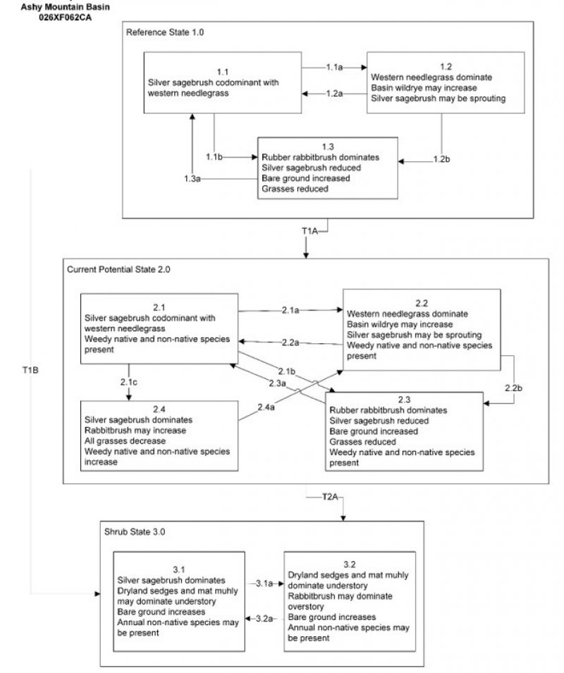
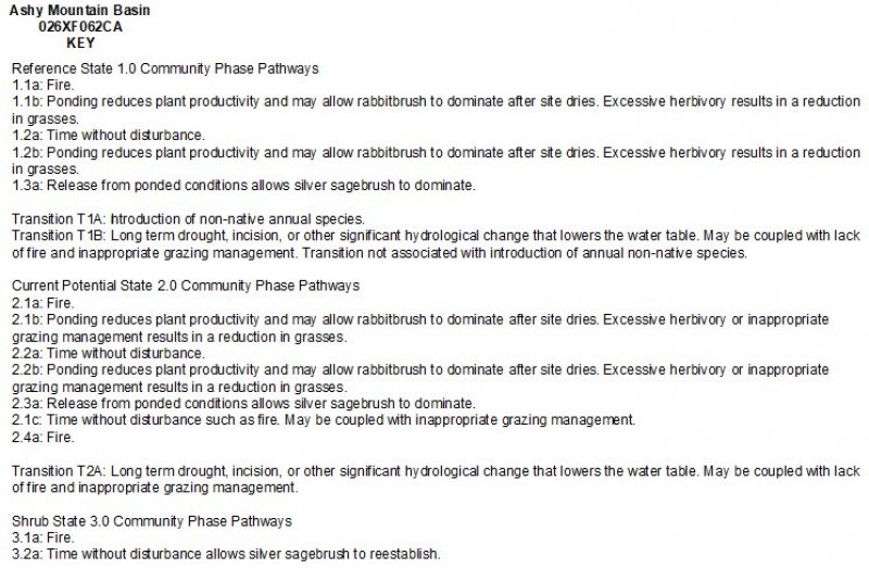
State and Transition Model Narrative Group 5
This is a text description of the states, phases, transitions, and community pathways possible in the State and Transition model for the MLRA 26 Disturbance Response Group 5. Other sites included in this group are R026XY049NV and R026XY037NV. All sites in this group respond similarly to disturbance and have similar state and transition models.
Reference State 1.0:
The reference state 1.0 is a representative of the natural range of variability under pristine conditions. The reference state has three general community phases: a shrub-grass dominant phase, a perennial grass dominant phase and a shrub dominant phase. State dynamics are maintained by interactions between climatic patterns, hydrology and disturbance regimes. Negative feedbacks enhance ecosystem resilience and contribute to the stability of the state. These include the presence of all structural and functional groups, low fine fuel loads, and retention of organic matter and nutrients. Plant community phase changes are primarily driven by fire, periodic drought and/or insect or disease attack.
Community Phase 1.1:
This community is dominated by silver sagebrush and needlegrasses. Mat muhly and western wheatgrass can be significant components. Forbs and other grasses make up smaller components.
Community Phase Pathway 1.1a, from Phase 1.1 to 1.2:
Fire will top-kill silver sagebrush and allow for the perennial bunchgrasses and mat-forming grasses to increase. Fire severity is dependent on amount of fine fuels in the understory.
Community Phase Pathway 1.1b, from Phase 1.1 to 1.3:
Ponding reduces plant productivity and may allow rabbitbrush to dominate.
Community Phase 1.2:
This community phase is characteristic of a post-disturbance, early- to mid-seral community. Needlegrasses and other perennial grasses dominate. Silver sagebrush is reduced within the community after fire, but will be sprouting. Rabbitbrush and other sprouting shrubs may increase. Perennial forbs may be a significant component for a number of years following fire. If coming from a Phase 1.3 (post-flood), silver sagebrush will reestablish by seed.
Community Phase Pathway 1.2a, from Phase 1.2 to 1.1:
Time and lack of disturbance will allow sagebrush to increase.
Community Phase Pathway 1.2b, from Phase 1.2 to 1.3:
Prolonged ponding reduces plant productivity, causes silver sagebrush stress, and may allow rabbitbrush to dominate once the site dries.
Community Phase 1.3:
Rubber rabbitbrush becomes dominant after a wet year or years that result in ponded conditions. Bare ground increases and may dominate the visual aspect. Silver sagebrush and grasses are reduced.
Community Phase Pathway 1.3a, from Phase 1.3 to 1.1:
Release from ponded conditions allows silver sagebrush to dominate.
T1A: Transition from the Reference State 1.0 to Current Potential State 2.0
Trigger: This transition is caused by the introduction of non-native annual plants.
Slow variables: Over time the annual non-native species will increase within the community.
Threshold: Any amount of introduced non-native species causes an immediate decrease in the resilience of the site. Annual non-native species cannot be easily removed from the system and have the potential to significantly alter disturbance regimes from their historic range of variation.
T1B: Transition from the Reference State 1.0 to Sagebrush State 3.0
Trigger: Long term drought, incision, or other significant hydrological change that lowers the water table. May be coupled with lack of fire and inappropriate grazing management. Transition not associated with introduction of annual non-native species.
Slow Variables: Silver sagebrush is not capable of surviving with a low water table. Over time, plants die off and are not capable of reproducing in the drier soil conditions. Wyoming big sagebrush is able to populate the area. If coupled with inappropriate grazing management, needlegrasses are lost from excessive long-term use.
Threshold: Permanent lowering of the water table beyond the reach of silver sagebrush that results in mortality of adult plants.
Current Potential State 2.0:
This state is similar to the Reference State 1.0. Ecological function has not changed, however the resiliency of the state has been reduced by the presence of invasive weeds. This state has four general community phases: a shrub-grass dominant phase, a perennial grass dominant phase, a shrub dominant phase and a sprouting shrub dominant phase. These non-native species can be highly flammable and promote fire where historically fire had been infrequent. Negative feedbacks enhance ecosystem resilience and contribute to the stability of the state. These feedbacks include the presence of all structural and functional groups, low fine fuel loads, and retention of organic matter and nutrients. Positive feedbacks decrease ecosystem resilience and stability of the state. These include the non-natives’ high seed output, persistent seed bank, rapid growth rate, ability to cross pollinate, and adaptations for seed dispersal.
Community Phase 2.1:
This community phase is similar to the Reference State Community Phase 1.1, with the presence of non-native species in trace amounts. Silver sagebrush, needlegrasses and mat muhly dominate the site. Forbs and other shrubs and grasses make up smaller components of this site.
Community Phase Pathway 2.1a, from Phase 2.1 to 2.2:
Fire will top kill silver sagebrush and allow for the herbaceous community to increase. Fire severity is dependent on amount of fine fuels in the understory. Annual non-native species are likely to increase after fire.
Community Phase Pathway 2.1b, from Phase 2.1 to 2.3:
Ponding reduces plant productivity and may allow rabbitbrush to dominate.
Community Phase Pathway 2.1c, from Phase 2.1 to 2.4:
Time without disturbance such as fire. May be coupled with inappropriate grazing management.
Community Phase 2.2:
This community phase is characteristic of a post-disturbance, early/mid-seral community. Needlegrasses and other perennial bunchgrasses dominate. Silver sagebrush is reduced within the community post-fire, but will resprout. Rabbitbrush and other sprouting shrubs may increase. Perennial forbs may be a significant component for a number of years following fire. If coming from a Phase 2.3 (post-flood), silver sagebrush will reestablish by seed. Annual non-native species are stable or increasing within the community.
Community Phase Pathway 2.2a, from Phase 2.2 to 2.1:
Time and lack of disturbance and/or grazing management that favors the establishment and growth of sagebrush allows the shrub component to recover. Silver sagebrush sprouts and will be able to return to pre-burn levels quickly.
Community Phase Pathway 2.2b, from Phase 2.2 to 2.3:
Prolonged ponding reduces plant productivity, causes silver sagebrush stress, and may allow rabbitbrush to dominate once the site dries.
Community Phase 2.3:
Rubber rabbitbrush becomes dominant after a wet year or years that result in ponded conditions. Bare ground increases and may dominate the visual aspect. Silver sagebrush and bunchgrasses are reduced.
Community Phase Pathway 2.3a, from Phase 2.3 to 2.1:
Release from ponded conditions allows silver sagebrush to dominate.
Community Phase 2.4:
Sagebrush dominates the overstory and perennial bunchgrasses in the understory are reduced, either from competition with shrubs or from inappropriate grazing, or from both. Rabbitbrush may be a significant component. Mat muhly may increase. This site is susceptible to further degradation from grazing, drought, and fire.
Community Phase Pathway 2.4a, from Phase 2.4 to 2.2:
Fire will top kill silver sagebrush and allow for the herbaceous community to increase. Fire severity is dependent on amount of fine fuels in the understory.
T2A: Transition from Current Potential State 2.0 to Sagebrush State 3.0
Trigger: Long term drought, incision, or other significant hydrological change that lowers the water table. May be coupled with lack of fire and inappropriate grazing management. Transition not associated with introduction of annual non-native species.
Slow Variables: Silver sagebrush is not capable of surviving with a water table below the rooting zone during spring growing season. Over time, plants die off and are not capable of reproducing in the drier soil conditions. Big sagebrush (Artemisia tridentata) is able to populate the area. If coupled with inappropriate grazing management, needlegrasses are lost from excessive long-term use. Rhizomatous grasses or dryland sedge may become the dominant understory.
Threshold: Permanent lowering of the water table beyond the reach of silver sagebrush that results in mortality of adult plants.
Shrub State 3.0:
This state has two community phases, a silver sagebrush-dominated phase and a post-fire phase. Long-term inappropriate grazing management reduces or eliminates grazing-intolerant grasses like needlegrasses and basin wildrye. Repeated heavy utilization in the spring or season-long use is damaging to the bunchgrass community on this site. Shrubs and grazing-tolerant grasses and grass-likes become dominant. The loss of deep-rooted grasses reduces the amount and depth of organic matter that is cycled in the soil. Shrub cover exceeds site concept and may be decadent, reflecting stand maturity and lack of seedling establishment due to competition with mature plants. The shrub overstory and rhizomatous grass and/or sedge understory dominate site resources such that soil water, nutrient capture, nutrient cycling and soil organic matter are temporally and spatially redistributed.
Community Phase 3.1:
Decadent silver sagebrush dominates the overstory. Deep-rooted perennial bunchgrasses are present in only trace amounts or are absent from the community. Mat muhly, western wheatgrass, and dryland sedges increase. Bare ground may be significant. Annual non-native species may be present.
Community Phase Pathway 3.1a, from Phase 3.1 to 3.2:
Fire reduces cover and production of silver sagebrush. Rabbitbrush sprouts after fire and becomes the dominant shrub. Mat muhly, western wheatgrass, and sedges survive fire and increase in the understory.
Community Phase 3.2:
Mat muhly, western wheatgrass, and/or Douglas sedge dominate. Rubber rabbitbrush may be a significant component. Basin wildrye and needlegrasses are missing. Silver sagebrush may be sprouting.
Community Phase Pathway 3.2a, from Phase 3.2 to 3.1:
Time without disturbance allows silver sagebrush to again become dominant.
The reference plant community is dominated by silver sagebrush, mountain big sagebrush and western needlegrass. Potential vegetative composition is approximately 50 percent grasses and grass-like plants, 10 percent forbs, and 40 percent shrubs. Approximate ground cover (basal and crown) is 30 to 40 percent.
Figure 1. Annual production by plant type (representative values) or group (midpoint values)
Table 5. Annual production by plant type
Plant type
Low (lb/acre)
Representative value (lb/acre)
High (lb/acre)
Grass/Grasslike
275
400
500
Shrub/Vine
220
320
400
Forb
55
80
100
Total
550
800
1000
Additional community tables
Table 6. Community 1.1 plant community composition
Livestock Interpretations:
Western needlegrass has a spreading and deeply penetrating root system, which makes it resistant to trampling. The early growth and abundant production of basin wildrye make it a valuable source of forage for livestock. It is important forage for cattle and is readily grazed by cattle and horses in early spring and fall. Though coarse-textured during the winter, basin wildrye may be utilized more frequently by livestock and wildlife when snow has covered low shrubs and other grasses. Bluegrass is a widespread forage grass. It is one of the earliest grasses in the spring and is sought by domestic livestock and several wildlife species. Sandberg bluegrass is a palatable species, but its production is closely tied to weather conditions. It produces little forage in drought years, making it a less dependable food source than other perennial bunchgrasses. Livestock use of silver sagebrush is variable depending upon availability of palatable herbs. Domestic sheep generally browse silver sagebrush more heavily than cattle. Livestock may actually make greater use of silver sagebrush when there is ample grass to go with it. Basin wildrye provides winter forage for mule deer, though use is often low compared to other native grasses. Basin wildrye provides summer forage for black-tailed jackrabbits. Because basin wildrye remains green throughout early summer, it remains available for small mammal forage for longer time than other grasses.
Mountain big sagebrush is eaten by domestic livestock but has long been considered to be of low palatability, and a competitor to more desirable species.
Wildlife Interpretations:
Silver sagebrush provides valuable habitat and forage for wildlife. Deer, pronghorn, bighorn sheep, and sage-grouse browse the foliage. Mule deer may browse silver sagebrush heavily when other forage is dormant. Silver sagebrush is also important on fall and winter ranges.
Mountain big sagebrush is highly preferred and nutritious winter forage for mule deer and elk.
Sage-grouse: Sagebrush-grassland communities provide critical sage-grouse breeding and nesting habitats. Meadows surrounded by sagebrush may be used as feeding and strutting grounds. Sagebrush is a crucial component of their diet year-round, and sage-grouse select sagebrush almost exclusively for cover. Sage-grouse prefer mountain big sagebrush and Wyoming big sagebrush communities to basin big sagebrush communities.
Other products
Tribes of the Great Basin used silver sagebrush branches as a fuelbed for roasting pinyon pinecones. Many tribes use the branches in ceremonial rites.
Native Americans used big sagebrush leaves and branches for medicinal teas, and the leaves as a fumigant. Bark was woven into mats, bags and clothing. Basin wildrye was used as bedding for various Native American ceremonies, providing a cool place for dancers to stand.
Other information
Silver sagebrush has potential as a soil stabilizer and for use in rangeland, wildlife and riparian restoration projects. Basin wildrye is useful in mine reclamation, fire rehabilitation and stabilizing disturbed areas. Its usefulness in range seeding, however, may be limited by initially weak stand establishment.
Supporting information
Type locality
Location 1: Mono County, CA
Latitude
38° 17′ 51″
Longitude
118° 58′ 47″
General legal description
Bodie Hills, Approximately 3 miles south-southeast of Bridgeport, California
A. Mushrush Tamzen Stringham Patti Novak-Echenique
Approval
Kendra Moseley, 4/10/2024
Rangeland health reference sheet
Interpreting Indicators of Rangeland Health is a qualitative assessment protocol used to
determine ecosystem condition based on benchmark characteristics described in the Reference Sheet. A suite of 17 (or
more) indicators are typically considered in an assessment. The ecological site(s) representative of an assessment
location must be known prior to applying the protocol and must be verified based on soils and climate. Current plant
community cannot be used to identify the ecological site.
Author(s)/participant(s)
Contact for lead author
Date
04/11/2024
Approved by
Kendra Moseley
Approval date
Composition (Indicators 10 and 12) based on
Annual Production
Indicators
Number and extent of rills:
Presence of water flow patterns:
Number and height of erosional pedestals or terracettes:
Bare ground from Ecological Site Description or other studies (rock, litter, lichen, moss, plant canopy are
not bare ground):
Number of gullies and erosion associated with gullies:
Extent of wind scoured, blowouts and/or depositional areas:
Amount of litter movement (describe size and distance expected to travel):
Soil surface (top few mm) resistance to erosion (stability values are averages - most sites will show a range
of values):
Soil surface structure and SOM content (include type of structure and A-horizon color and thickness):
Effect of community phase composition (relative proportion of different functional groups) and spatial
distribution on infiltration and runoff:
Presence and thickness of compaction layer (usually none; describe soil profile features which may be
mistaken for compaction on this site):
Functional/Structural Groups (list in order of descending dominance by above-ground annual-production or live foliar
cover using symbols: >>, >, = to indicate much greater than, greater than, and equal to):
Dominant:
Sub-dominant:
Other:
Additional:
Amount of plant mortality and decadence (include which functional groups are expected to show mortality or
decadence):
Average percent litter cover (%) and depth ( in):
Expected annual annual-production (this is TOTAL above-ground annual-production, not just forage annual-production):
Potential invasive (including noxious) species (native and non-native). List species which BOTH characterize
degraded states and have the potential to become a dominant or co-dominant species on the ecological site if
their future establishment and growth is not actively controlled by management interventions. Species that become
dominant for only one to several years (e.g., short-term response to drought or wildfire) are not invasive
plants. Note that unlike other indicators, we are describing what is NOT expected in the reference state for the
ecological site:
The Ecosystem Dynamics Interpretive Tool is an information system framework developed by the USDA-ARS Jornada Experimental Range, USDA Natural Resources Conservation Service, and New Mexico State University.
Click on box and path labels to scroll to the respective text.