Provisional. A provisional ecological site description has undergone quality control and quality assurance review. It contains a working state and transition model and enough information to identify the ecological site.
MLRA notes
Major Land Resource Area (MLRA): 026X–Carson Basin and Mountains
The area lies within western Nevada and eastern California, with about 69 percent being within Nevada, and 31 percent being within California. Almost all this area is in the Great Basin Section of the Basin and Range Province of the Intermontane Plateaus. Isolated north-south trending mountain ranges are separated by aggraded desert plains. The mountains are uplifted fault blocks with steep side slopes. Most of the valleys are drained by three major rivers flowing east across this MLRA. A narrow strip along the western border of the area is in the Sierra Nevada Section of the Cascade-Sierra Mountains Province of the Pacific Mountain System. The Sierra Nevada Mountains are primarily a large fault block that has been uplifted with a dominant tilt to the west. This structure leaves an impressive wall of mountains directly west of this area. This helps create a rain shadow affect to MLRA 26. Parts of this eastern face, but mostly just the foothills, mark the western boundary of this area. Elevations range from about 3,806 feet (1,160 meters) on the west shore of Pyramid Lake to 11,653 feet (3,552 meters) on the summit of Mount Patterson in the Sweetwater Mountains.
Valley areas are dominantly composed of Quaternary alluvial deposits with Quaternary playa or alluvial flat deposits often occupying the lowest valley bottoms in the internally drained valleys, and river deposited alluvium being dominant in externally drained valleys. Hills and mountains are dominantly Tertiary andesitic flows, breccias, ash flow tuffs, rhyolite tuffs or granodioritic rocks. Quaternary basalt flows are present in lesser amounts, and Jurassic and Triassic limestone and shale, and Precambrian limestone and dolomite are also present in very limited amounts. Also of limited extent are glacial till deposits along the east flank of the Sierra Nevada Mountains, the result of alpine glaciation.
The average annual precipitation in this area is 5 to 36 inches (125 to 915 millimeters), increasing with elevation. Most of the rainfall occurs as high-intensity, convective storms in spring and autumn. Precipitation is mostly snow in winter. Summers are dry. The average annual temperature is 37 to 54 degrees F (3 to 12 degrees C). The freeze-free period averages 115 days and ranges from 40 to 195 days, decreasing in length with elevation.
The dominant soil orders in this MLRA are Aridisols and Mollisols. The soils in the area dominantly have a mesic soil temperature regime, an aridic or xeric soil moisture regime, and mixed or smectitic mineralogy. They generally are well drained, are clayey or loamy and commonly skeletal, and are very shallow to moderately deep.
This area supports shrub-grass vegetation characterized by big sagebrush. Low sagebrush and Lahontan sagebrush occur on some soils. Antelope bitterbrush, squirreltail, desert needlegrass, Thurber needlegrass, and Indian ricegrass are important associated plants. Green ephedra, Sandberg bluegrass, Anderson peachbrush, and several forb species also are common. Juniper-pinyon woodland is typical on mountain slopes. Jeffrey pine, lodgepole pine, white fir, and manzanita grow on the highest mountain slopes. Shadscale is the typical plant in the drier parts of the area. Sedges, rushes, and moisture-loving grasses grow on the wettest parts of the wet flood plains and terraces. Basin wildrye, alkali sacaton, saltgrass, buffaloberry, black greasewood, and rubber rabbitbrush grow on the drier sites that have a high concentration of salts.
Some of the major wildlife species in this area are mule deer, coyote, beaver, muskrat, jackrabbit, cottontail, raptors, pheasant, chukar, blue grouse, mountain quail, and mourning dove. The species of fish in the area include trout and catfish. The Lahontan cutthroat trout in the Truckee River is a threatened and endangered species.
LRU notes
The Semiarid Fans and Basins LRU includes basins, alluvial fans and adjacent hill slopes immediately east of the Sierra Nevada mountain range and are affected by its climate or have its granitic substrate. Elevations range from 1355 to 1920 meters and slopes range from 0 to 30 percent, with a median value of 6 percent. Frost free days range from 121 to 170.
Ecological site concept
This site occurs on axial-stream flood plains and terraces. Slopes generally range from 0 to 2 percent. Elevations are 4400 to 4800 feet. The soils are moderately to very deep and poorly to somewhat poorly drained. The soils are strongly saline-alkali affected and bake and crust upon drying, inhibiting seedling establishment. The soils are occasionally flooded and a seasonal water table fluctuates from 12 inches in spring to over 60 inches during drier periods. The dominant plants are black greasewood (Sarcobatus vermiculatus), alkali sacaton (Sporobolus airoides), and saltgrass (Distichlis spicata).
This site occurs on axial-stream flood plains and terraces. Slopes generally range from 0 to 2 percent. Elevations are 4400 to 4800 feet.
Table 2. Representative physiographic features
Landforms
(1) Stream terrace (2) Flood plain
Flooding duration
Very brief (4 to 48 hours)
Flooding frequency
Rare
Ponding frequency
None
Elevation
1,341–1,463 m
Slope
0–2%
Water table depth
30–152 cm
Aspect
Aspect is not a significant factor
Climatic features
The climate associated with this site is semiarid, characterized by cool, moist winters and warm, dry summers. Average annual precipitation is 8 to 10 inches. Mean annual air temperature is 48 to 53 degrees F. The average growing season is about 90 to 125 days.
Nevada’s climate is predominantly arid, with large daily ranges of temperature, infrequent severe storms, heavy snowfall in the higher mountains, and great location variations with elevation. Three basic geographical factors largely influence Nevada’s climate: continentality, latitude, and elevation. Continentality is the most important factor. The strong continental effect is expressed in the form of both dryness and large temperature variations. Nevada lies on the eastern, lee side of the Sierra Nevada Range, a massive mountain barrier that markedly influences the climate of the State. The prevailing winds are from the west, and as the warm moist air from the Pacific Ocean ascend the western slopes of the Sierra Range, the air cools, condensation occurs and most of the moisture falls as precipitation. As the air descends the eastern slope, it is warmed by compression, and very little precipitation occurs. The effects of this mountain barrier are felt not only in the West but throughout the state, with the result that the lowlands of Nevada are largely desert or steppes. The temperature regime is also affected by the blocking of the inland-moving maritime air. Nevada sheltered from maritime winds, has a continental climate with well-developed seasons and the terrain responds quickly to changes in solar heating.
Nevada lies within the mid-latitude belt of prevailing westerly winds which occur most of the year. These winds bring frequent changes in weather during the late fall, winter and spring months, when most of the precipitation occurs. To the south of the mid-latitude westerlies, lies a zone of high pressure in subtropical latitudes, with a center over the Pacific Ocean. In the summer, this high-pressure belt shifts northward over the latitudes of Nevada, blocking storms from the ocean. The resulting weather is mostly clear and dry during the summer and early fall, with scattered thundershowers. The eastern portion of the state receives significant summer thunderstorms generated from monsoonal moisture pushed up from the Gulf of California, known as the North American monsoon. The monsoon system peaks in August and by October the monsoon high over the Western U.S. begins to weaken and the precipitation retreats southward towards the tropics (NOAA 2004).
Table 3. Representative climatic features
Frost-free period (characteristic range)
Freeze-free period (characteristic range)
Precipitation total (characteristic range)
203-254 mm
Frost-free period (average)
107 days
Freeze-free period (average)
Precipitation total (average)
229 mm
Bar
Line
Figure 1. Monthly average minimum and maximum temperature
Figure 2. Annual precipitation pattern
Figure 3. Annual average temperature pattern
Influencing water features
This site is associated with axial-stream flood plains and terraces subject to occasional flooding.
Soil features
The soils are moderately to very deep and poorly to somewhat poorly drained. The available water capacity is low to moderate. The soils are strongly saline-alkali affected and bake and crust upon drying, inhibiting seedling establishment. The soils are occasionally flooded and a seasonal water table fluctuates from 12 inches in spring to over 60 inches during drier periods. Because of occasional overland flow, these soils are highly susceptible to gullying. Runoff is medium to very high. The soil series associated with this site include: Dangberg, Fettic, Nofet, Sagouspe, Truckee, Voltaire, Pullout, and Voltcan.
Table 4. Representative soil features
Parent material
(1) Alluvium
Surface texture
(1) Clay
(2) Silt loam
(3) Very fine sandy loam
Family particle size
(1) Clayey
Drainage class
Poorly drained to somewhat poorly drained
Permeability class
Very slow to moderately rapid
Soil depth
61–213 cm
Surface fragment cover <=3"
0–4%
Surface fragment cover >3"
0%
Available water capacity (0-101.6cm)
7.62–18.8 cm
Calcium carbonate equivalent (0-101.6cm)
0–5%
Electrical conductivity (0-101.6cm)
0–32 mmhos/cm
Sodium adsorption ratio (0-101.6cm)
0–90
Soil reaction (1:1 water) (0-101.6cm)
7.9–9.6
Subsurface fragment volume <=3" (Depth not specified)
0–4%
Subsurface fragment volume >3" (Depth not specified)
0%
Ecological dynamics
As ecological condition deteriorates inland saltgrass, black greasewood, rubber rabbitbrush and big saltbush increase. Plants which are tolerant of strongly saline-alkali conditions and the fluctuating water table are dominant on this site. Species most likely to invade this site are annuals.
Fire Ecology:
Black greasewood communities have been historically subject to stand-replacing fire regimes with intervals of <100 years. Black greasewood may be killed by severe fires, but it commonly sprouts soon after low to moderate-severity fire. Torrey’s quailbush has been shown to have reduced flammability due to high moisture and ash contents. Torrey’s quailbush can survive at least some fires. The limited information available suggests that the most likely postfire regeneration strategy of Torrey’s quailbush is seed production.
Alkali sacaton is classified as tolerant of, but not resistant to, fire. Top-killing by fire is probably frequent, and the plants can be killed by severe fire. Saltgrass rhizomes occur deep in the soil where they are insulated from the heat of most fires. Saltgrass survives fire by sending up new growth from rhizomes. Basin wildrye is top-killed by fire. Older basin wildrye plants with large proportions of dead material within the perennial crown can be expected to show higher mortality due to fire than younger plants having little debris. Basin wildrye is generally tolerant of fire but may be damaged by early season fire combined with dry soil conditions.
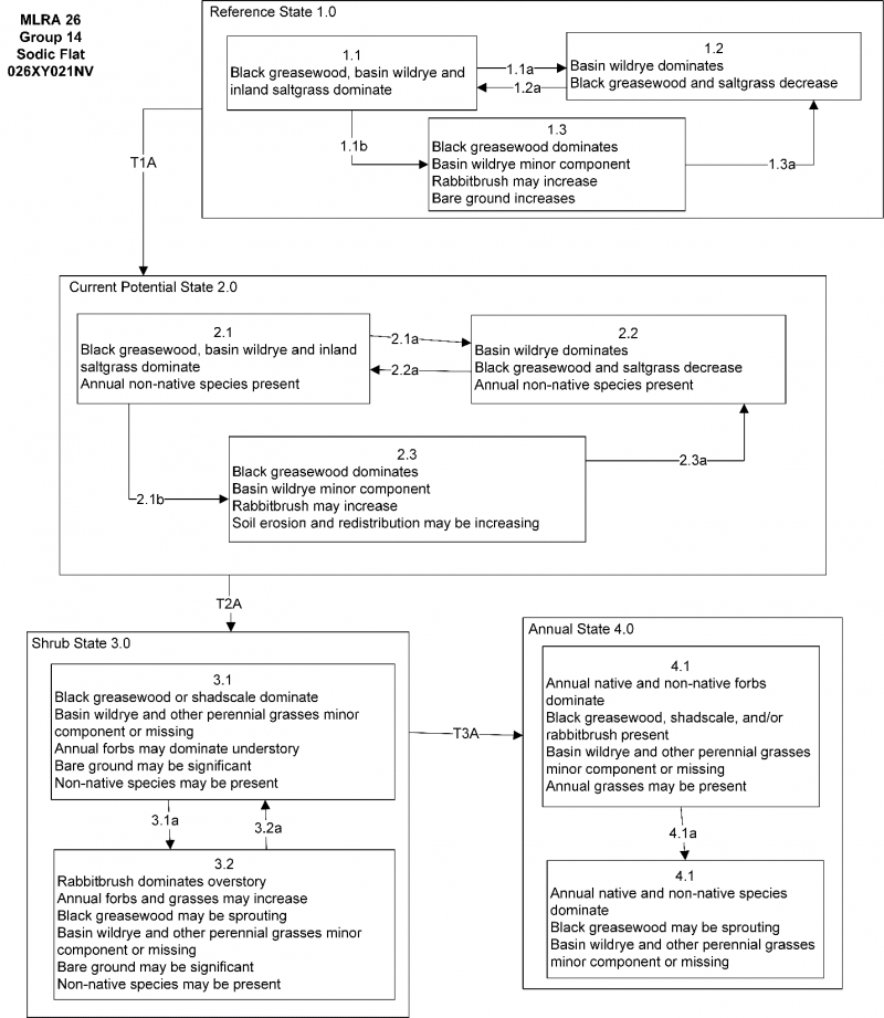
State and Transition Model Narrative – Group 14
This is a text description of the states, phases, transitions, and community pathways possible in the State and Transition model for MLRA 26 Disturbance Response Group 14. Sites included in this group are R026XY021NV, R026XY013NV, and R026XY004NV.
Reference State 1.0:
The Reference State 1.0 represents the natural range of variability under pristine conditions. The Reference State has three general community phases: a shrub-grass dominant phase, a perennial grass dominant phase and a shrub dominant phase. State dynamics are maintained by interactions between climatic patterns and disturbance regimes. Negative feedbacks enhance ecosystem resilience and contribute to the stability of the state. These include the presence of all structural and functional groups, low fine fuel loads, and retention of organic matter and nutrients. Plant community phase changes are primarily driven by fire, periodic long-term drought and/or insect or disease attack.
Community Phase 1.1:
This community is dominated by black greasewood. Shadscale and rubber rabbitbrush are also common. The herbaceous understory is dominated by basin wildrye and inland saltgrass. Squirreltail and alkali sacaton make up minor components.
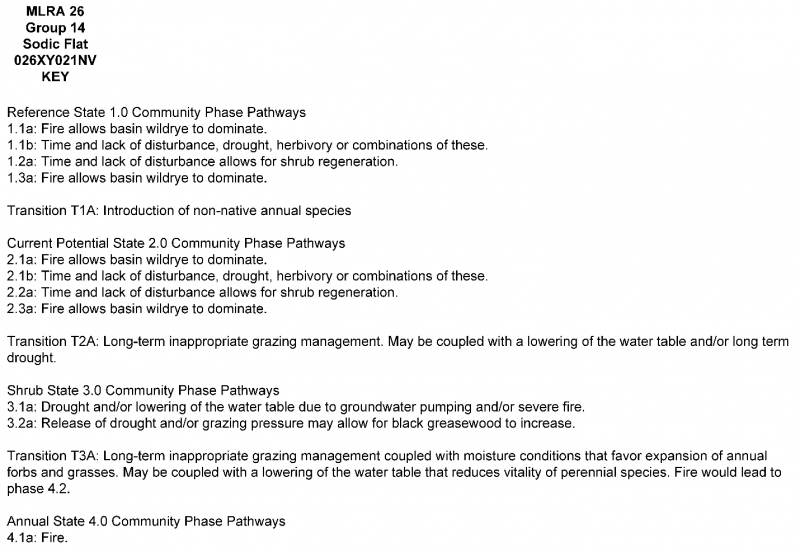
Community Phase Pathway 1.1a, from phase 1.1 to 1.2:
A low severity fire would decrease the overstory of black greasewood and allow the understory perennial grasses to increase. Fires are typically low severity and rare due to low fuel loadsbut would result in a mosaic pattern of shrubs and grasses. A fire following an unusually wet spring facilitating an increase in fine fuels may be more severe and reduce black greasewood cover to trace amounts.
Community Phase Pathway 1.1b, from phase 1.1 to 1.3:
Absence of disturbance over time, significant herbivory, long term drought, or combinations of these would allow the black greasewood overstory to increase and dominate the site. This will generally cause a reduction in basin wildrye. Inland saltgrass may increase in the understory depending on the timing and intensity of herbivory. Heavy spring utilization will favor an increase in black greasewood.
Community Phase 1.2:
This community phase is characteristic of a post-disturbance, early-seral community phase. Basin wildrye dominates the community. Black greasewood will decrease but will likely sprout and return to pre-burn levels within a few years. Early colonizers such as rabbitbrush and inland saltgrass may increase.
Community Phase Pathway 1.2a, from phase 1.2 to 1.1:
Time and lack of disturbance will allow shrubs to increase.
Community Phase 1.3:
Black greasewood and shadscale increase in the absence of disturbance. Decadent shrubs dominate the overstory and basin wildrye is reduced either from competition with shrubs, herbivory, drought, or combinations of these.
Community Phase Pathway 1.3a, from phase 1.3 to 1.1:
Fire will decrease the overstory of black greasewood and allow for the perennial bunchgrasses to dominate the site. Fires will typically be high intensity in this phase due to the dominance of greasewood, resulting in removal of the overstory shrub community.
T1A: Transition from Reference State 1.0 to Current Potential State 2.0:
Trigger: This transition is caused by the introduction of non-native annual plants, such as cheatgrass, mustards, halogeton, or Russian thistle.
Slow variables: Over time the annual non-native species will increase within the community.
Threshold: Any amount of introduced non-native species causes an immediate decrease in the resilience of the site. Annual non-native species cannot be easily removed from the system and have the potential to significantly alter disturbance regimes from their historic range of variation.
Current Potential State 2.0:
This state is similar to the Reference State 1.0 with three similar community phases. Ecological function has not changed; however, the resilience of the state has been reduced by the presence of invasive weeds. Non-natives may increase in abundance but will not become dominant within this State. These non-natives can be highly flammable and can promote fire where historically fire had been infrequent. Negative feedbacks enhance ecosystem resilience and contribute to the stability of the state. These feedbacks include the presence of all structural and functional groups, low fine fuel loads, and retention of organic matter and nutrients. Positive feedbacks decrease ecosystem resilience and stability of the state. These include the non-natives’ high seed output, persistent seed bank, rapid growth rate, ability to cross pollinate, and adaptations for seed dispersal.
Community Phase 2.1:
This community phase is similar to the Reference State Community Phase 1.1. This community is dominated by black greasewood. Shadscale and rubber rabbitbrush are also common. The herbaceous understory is dominated by basin wildrye and inland saltgrass. Squirreltail and alkali sacaton make up minor components. Non-native annual species such as halogeton, Russian thistle and cheatgrass are present.
Community Phase Pathway 2.1a, from Phase 2.1 to 2.2:
A low severity fire would decrease the overstory of black greasewood and allow the understory perennial grasses to increase. Fires are typically low severity and rare due to low fuel loads but would result in a mosaic pattern of shrubs and grasses. A fire following an unusually wet spring facilitating an increase in fine fuels may be more severe and reduce black greasewood cover to trace amounts. Brush treatments with minimal soil disturbance may also reduce black greasewood and allow for perennial bunchgrasses to increase. Annual non-native species are likely to increase after fire.
Community Phase Pathway 2.1b, from Phase 2.1 to 2.3:
Absence of disturbance over time, significant herbivory, long term drought, or combinations of these would allow the black greasewood overstory to increase and dominate the site. Inappropriate grazing management reduces basin wildrye, and inland saltgrass may increase in the understory.
Community Phase 2.2:
This community phase is characteristic of a post-disturbance, early-seral community phase. Basin wildrye dominates the community. Black greasewood will decrease but will likely sprout and return to pre-burn levels within a few years. Early colonizers such as rabbitbrush and inland saltgrass may increase. Annual non-native species are stable to increasing in the community.
Community Phase Pathway 2.2a, form Phase 2.2 to 2.1:
Absence of disturbance over time and/or grazing management that favors the establishment and growth of black greasewood allows the shrub component to recover.
Community Phase 2.3:
Black greasewood and shadscale increase in the absence of disturbance. Decadent shrubs dominate the overstory and basin wildrye is reduced either from competition with shrubs, herbivory, drought, or combinations of these. Annual non-native species are stable or increasing. This community is at risk of crossing a threshold to the Shrub State.
Community Phase Pathway 2.3a, from Phase 2.3 to 2.2:
Grazing management that reduces shrubs will allow for the perennial bunchgrasses in the understory to increase. Heavy late-fall/winter grazing may cause mechanical damage to black greasewood promoting the perennial bunchgrass understory. Brush treatments with minimal soil disturbance will also decrease black greasewood and release the perennial understory. Annual non-native species are present and may increase in the community. Fire will decrease the overstory of black greasewood and allow for the perennial bunchgrasses to dominate the site. Fires will typically be high intensity in this phase due to the dominance of greasewood, resulting in removal of the overstory shrub community.
T2A: Transition from Current Potential State 2.0 to Shrub State 3.0:
Trigger: To Community Phase 3.1: Inappropriate cattle/horse grazing will decrease or eliminate deep rooted perennial bunchgrasses and favor shrub growth and establishment. To Community Phase 3.2: Severe fire will reduce and/or eliminate the black greasewood overstory. Soil disturbing brush treatments will reduce black greasewood and possibly increase non-native annual species. Lowering of the water table due to groundwater pumping will also decrease basin wildrye and black greasewood, and will allow rabbitbrush and other shrubs to increase.
Slow variables: Long term decline in perennial grass density.
Threshold: Loss of perennial grasses alters nutrient cycling, nutrient redistribution, and reduces soil organic matter. Loss of long-lived black greasewood changes the temporal and the spatial distribution of nutrient cycling depending on the replacement shrub.
Shrub State 3.0:
This state has two community phases, one that is characterized by a dominance of a black greasewood overstory and the other with a rabbitbrush overstory. This site has crossed a biotic and abiotic threshold and site processes are being controlled by shrubs. Bare ground has increased and pedestalling of grasses may be excessive.
Community Phase 3.1:
Black greasewood dominates the overstory. Perennial grasses have significantly declined and may be missing. Annual non-native species increase. Bare ground is significant; however, there may be occasional flushes of annual forbs with certain moisture conditions in winter and spring.
Community Phase Pathway 3.1a, from Phase 3.1 to 3.2:
Long term drought and/or lowering of water table by groundwater pumping would reduce black greasewood and allow rabbitbrush and other shrubs on the site to dominate. Severe fire would also reduce black greasewood overstory and allow for an increase in rabbitbrush.
Community Phase 3.2:
Rabbitbrush is a significant component. Native and non-native annual forbs (primarily mustards) present. Perennial bunchgrasses may be present but are a minor component. Bare ground may be significant in years with little moisture to support an annual community.
Community Phase Pathway 3.2a, from Phase 3.2 to 3.1:
Release from drought conditions may allow black greasewood to increase.
T3A: Transition from Shrub State 3.0 to Annual State 4.0:
Trigger: Fire, or moisture conditions that cause a sudden increase in density and production of annual plants. May be coupled with a lowering of the water table that reduces vitality of perennial species.
Slow variable: Increasing non-native annuals causes an increase of fine fuel loads over time. These fuel loads cause frequent fires, or build up over time until it causes a catastrophic fire.
Threshold: Annual forbs and/or grasses dominate the site. Loss of perennial grasses changes spatial and temporal nutrient cycling and nutrient redistribution, and reduces soil organic matter. Non-native annual species increase in the seedbank and respond positively to fire.
Annual State 4.0:
This state has one community phase characterized by the dominance of annual native and non-native species such as western tansymustard and cheatgrass in the understory. Time since fire may facilitate the maturation of sprouting shrubs. Ecological dynamics are significantly altered in this state. Annual non-native species create a highly combustible fuel bed that shortens the fire return interval. Nutrient cycling is spatially and temporally truncated as annual plants contribute significantly less to deep soil carbon. Some perennial grasses may remain but they are a minor component. Without management, it is unlikely these plants will be able to recruit in the presence of dominant annual plants.
Community Phase 4.1:
Annual non-native species dominate. Black greasewood, other shrubs, and perennial bunchgrasses are a minor component or missing. Soil redistribution and erosion may be significant.
Community Phase Pathway 4.1a, from Phase 4.1 to 4.2:
Fire reduces shrub community and allows annuals to dominate.
Community Phase 4.2:
This is a post-fire community phase. Native and non-native annual forbs and grasses dominate. Black greasewood may be sprouting.
State and transition model
Custom diagram
Standard diagram
Figure 4. Similar STM in the Disturbance Response Group.
The reference plant community is dominated by alkali sacaton, inland saltgrass and black greasewood. Potential vegetative composition is about 75% grasses and grass-like plants, 5% forbs and 20% shrubs. Approximate ground cover (basal and crown) is 25 to 35 percent.
Figure 5. Annual production by plant type (representative values) or group (midpoint values)
Table 5. Annual production by plant type
Plant type
Low (kg/hectare)
Representative value (kg/hectare)
High (kg/hectare)
Shrub/Vine
280
392
448
Grass/Grasslike
252
353
404
Forb
28
39
45
Total
560
784
897
Additional community tables
Table 6. Community 1.1 plant community composition
Livestock Interpretations:
This site is suited for livestock grazing. Grazing managment should be keyed to alkali sacaton and inland saltgrass. Saltgrass's value as forage depends primarily on the relative availability of other grasses of higher nutritional value and palatability. It can be an especially important late summer grass in arid environments after other forage grasses have deceased. Saltgrass is rated fair to good forage species only because it stays green after most other grasses dry. Livestock generally avoid saltgrass due to its coarse foliage. Saltgrass is described as an “increaser” under grazing pressure. Alkali sacaton is a valuable forage species in arid and semiarid regions. Plants are tolerant to moderate grazing and can produce abundant herbage utilized by livestock. The early growth and abundant production of basin wildrye make it a valuable source of forage for livestock. It is important forage for cattle and is readily grazed by cattle and horses in early spring and fall. Though coarse-textured during the winter, basin wildrye may be utilized more frequently by livestock and wildlife when snow has covered low shrubs and other grasses. Black greasewood is an important winter browse plant for domestic sheep and cattle. It also receives light to moderate use by domestic sheep and cattle during spring and summer months. Black greasewood contains soluble sodium and potassium oxalates that may cause poisoning and death in domestic sheep and cattle if large amounts are consumed in a short time. Livestock browse the leaves of Torrey’s quailbush.
Stocking rates vary over time depending upon season of use, climate variations, site, and previous and current management goals. A safe starting stocking rate is an estimated stocking rate that is fine tuned by the client by adaptive management through the year and from year to year.
Wildlife Interpretations:
The western saltdesert shrub and grassland communities where alkali sacaton is common support an abundance of mule deer, pronghorn, carnivores, small mammals, birds, amphibians, and reptiles. Black greasewood is an important winter browse plant for big game animals and a food source for many other wildlife species. It also receives light to moderate use by mule deer and pronghorn during spring and summer months. Leaves and seeds of Torrey’s quailbush are eaten by many species. Mule deer and pronghorn browse the leaves. Small mammals such as rabbits and rodents have been reported to eat Torrey’s quailbush. Dense stands of Torrey’s quailbush provide excellent cover for several species. The western salt desert shrub and grassland communities where alkali sacaton is common support an abundance of mule deer, pronghorn, carnivores, small mammals, birds, amphibians, and reptiles. Saltgrass provides cover for a variety of bird species, small mammals, and arthropods and is on occasion used as forage for several big game wildlife species. Basin wildrye provides winter forage for mule deer, though use is often low compared to other native grasses. Basin wildrye provides summer forage for black-tailed jackrabbits. Because basin wildrye remains green throughout early summer, it remains available for small mammal forage for longer time than other grasses.
Hydrological functions
Runoff is medium to very high. Permeability is very slow to moderately rapid.
Recreational uses
Aesthetic value is derived from the diverse floral and faunal composition and the colorful flowering of wild flowers and shrubs during the spring and early summer. This site offers rewarding opportunities to photographers and for nature study. This site is used for camping and hiking and has potential for upland and big game hunting.
Other products
The leaves, seeds and stems of black greasewood are edible. Tribes of the American southwest used Torrey’s quailbush seeds to make a thick gruel. They made flour to make small cakes, used the leaves as soap, and used the flowers, stems and leaves as a treatment for nasal congestion. The seeds were likely used in a similar way to fourwing saltbush. Seeds of fourwing saltbush were also reportedly ground into flour. Other uses for fourwing saltbush that may have been similar for big saltbush are the use of the ground meal as an emetic, use of ground flowers or roots moistened with saliva in treating ant bites, and addition of ashes to water for dyeing meal greenish-blue.
Other information
Given its extensive system of rhizomes and roots which form a dense sod, saltgrass is considered an outstanding species for controlling wind and water erosion. Alkali sacaton is one of the most commonly used species for seeding and stabilizing disturbed lands. Due to alkali sacaton’s salt tolerance, is recommended for native grass seeding on subirrigated saline sites. Black greasewood is useful for stabilizing soil on wind-blown areas. It successfully revegetates processed oil shale and is commonly found on eroded areas and sites too saline for most plant species. Torrey’s quailbush is a recommended revegetation species in riparian areas throughout its range and has also been used in revegetation projects in other habitats. Given its extensive system of rhizomes and roots which form a dense sod, saltgrass is considered a suitable species for controlling wind and water erosion.
Supporting information
Type locality
Location 1: Carson City County, NV
General legal description
This site also occurs in Douglas, Lyon, Mineral, Storey, and Washoe Counties.
Interpreting Indicators of Rangeland Health is a qualitative assessment protocol used to
determine ecosystem condition based on benchmark characteristics described in the Reference Sheet. A suite of 17 (or
more) indicators are typically considered in an assessment. The ecological site(s) representative of an assessment
location must be known prior to applying the protocol and must be verified based on soils and climate. Current plant
community cannot be used to identify the ecological site.
Author(s)/participant(s)
Contact for lead author
Date
03/14/2025
Approved by
Kendra Moseley
Approval date
Composition (Indicators 10 and 12) based on
Annual Production
Indicators
Number and extent of rills:
Presence of water flow patterns:
Number and height of erosional pedestals or terracettes:
Bare ground from Ecological Site Description or other studies (rock, litter, lichen, moss, plant canopy are
not bare ground):
Number of gullies and erosion associated with gullies:
Extent of wind scoured, blowouts and/or depositional areas:
Amount of litter movement (describe size and distance expected to travel):
Soil surface (top few mm) resistance to erosion (stability values are averages - most sites will show a range
of values):
Soil surface structure and SOM content (include type of structure and A-horizon color and thickness):
Effect of community phase composition (relative proportion of different functional groups) and spatial
distribution on infiltration and runoff:
Presence and thickness of compaction layer (usually none; describe soil profile features which may be
mistaken for compaction on this site):
Functional/Structural Groups (list in order of descending dominance by above-ground annual-production or live foliar
cover using symbols: >>, >, = to indicate much greater than, greater than, and equal to):
Dominant:
Sub-dominant:
Other:
Additional:
Amount of plant mortality and decadence (include which functional groups are expected to show mortality or
decadence):
Average percent litter cover (%) and depth ( in):
Expected annual annual-production (this is TOTAL above-ground annual-production, not just forage annual-production):
Potential invasive (including noxious) species (native and non-native). List species which BOTH characterize
degraded states and have the potential to become a dominant or co-dominant species on the ecological site if
their future establishment and growth is not actively controlled by management interventions. Species that become
dominant for only one to several years (e.g., short-term response to drought or wildfire) are not invasive
plants. Note that unlike other indicators, we are describing what is NOT expected in the reference state for the
ecological site:
The Ecosystem Dynamics Interpretive Tool is an information system framework developed by the USDA-ARS Jornada Experimental Range, USDA Natural Resources Conservation Service, and New Mexico State University.
Click on box and path labels to scroll to the respective text.