Provisional. A provisional ecological site description has undergone quality control and quality assurance review. It contains a working state and transition model and enough information to identify the ecological site.
MLRA notes
Major Land Resource Area (MLRA): 026X–Carson Basin and Mountains
The area lies within western Nevada and eastern California, with about 69 percent being within Nevada, and 31 percent being within California. Almost all this area is in the Great Basin Section of the Basin and Range Province of the Intermontane Plateaus. Isolated north-south trending mountain ranges are separated by aggraded desert plains. The mountains are uplifted fault blocks with steep side slopes. Most of the valleys are drained by three major rivers flowing east across this MLRA. A narrow strip along the western border of the area is in the Sierra Nevada Section of the Cascade-Sierra Mountains Province of the Pacific Mountain System. The Sierra Nevada Mountains are primarily a large fault block that has been uplifted with a dominant tilt to the west. This structure leaves an impressive wall of mountains directly west of this area. This helps create a rain shadow affect to MLRA 26. Parts of this eastern face, but mostly just the foothills, mark the western boundary of this area. Elevations range from about 3,806 feet (1,160 meters) on the west shore of Pyramid Lake to 11,653 feet (3,552 meters) on the summit of Mount Patterson in the Sweetwater Mountains.
Valley areas are dominantly composed of Quaternary alluvial deposits with Quaternary playa or alluvial flat deposits often occupying the lowest valley bottoms in the internally drained valleys, and river deposited alluvium being dominant in externally drained valleys. Hills and mountains are dominantly Tertiary andesitic flows, breccias, ash flow tuffs, rhyolite tuffs or granodioritic rocks. Quaternary basalt flows are present in lesser amounts, and Jurassic and Triassic limestone and shale, and Precambrian limestone and dolomite are also present in very limited amounts. Also of limited extent are glacial till deposits along the east flank of the Sierra Nevada Mountains, the result of alpine glaciation.
The average annual precipitation in this area is 5 to 36 inches (125 to 915 millimeters), increasing with elevation. Most of the rainfall occurs as high-intensity, convective storms in spring and autumn. Precipitation is mostly snow in winter. Summers are dry. The average annual temperature is 37 to 54 degrees F (3 to 12 degrees C). The freeze-free period averages 115 days and ranges from 40 to 195 days, decreasing in length with elevation.
The dominant soil orders in this MLRA are Aridisols and Mollisols. The soils in the area dominantly have a mesic soil temperature regime, an aridic or xeric soil moisture regime, and mixed or smectitic mineralogy. They generally are well drained, are clayey or loamy and commonly skeletal, and are very shallow to moderately deep.
This area supports shrub-grass vegetation characterized by big sagebrush. Low sagebrush and Lahontan sagebrush occur on some soils. Antelope bitterbrush, squirreltail, desert needlegrass, Thurber needlegrass, and Indian ricegrass are important associated plants. Green ephedra, Sandberg bluegrass, Anderson peachbrush, and several forb species also are common. Juniper-pinyon woodland is typical on mountain slopes. Jeffrey pine, lodgepole pine, white fir, and manzanita grow on the highest mountain slopes. Shadscale is the typical plant in the drier parts of the area. Sedges, rushes, and moisture-loving grasses grow on the wettest parts of the wet flood plains and terraces. Basin wildrye, alkali sacaton, saltgrass, buffaloberry, black greasewood, and rubber rabbitbrush grow on the drier sites that have a high concentration of salts.
Some of the major wildlife species in this area are mule deer, coyote, beaver, muskrat, jackrabbit, cottontail, raptors, pheasant, chukar, blue grouse, mountain quail, and mourning dove. The species of fish in the area include trout and catfish. The Lahontan cutthroat trout in the Truckee River is a threatened and endangered species.
LRU notes
The Sierra Influenced Ranges LRU is characterized by wooded great basin mountains with climatic and biotic affinities to the Sierra Nevada mountain range. The Sierra Influences Ranges LRU receives greater precipitation that the mountain ranges of central NV. Amount of precipitation varies in relation to the local strength of the Sierra NV rain shadow, characterized by pinyon and juniper trees. The White, Sweetwater, Pine Nut, Wassuk, and Virginia ranges of Nevada support varying amounts of Sierra Nevada flora, such as ponderosa pine. Elevations range from 1610 to 2420 meters and slopes range from 5 to 49 percent, with a median value of 22 percent. Frost free days (FFD) ranges from 92 to 163.
Ecological site concept
The Churning Clay 8-10 P.Z. site occurs on nearly level to slightly sloping hills and plateaus slopes. The soils associated with this site are moderately deep to very deep and well drained. On partial drying, deep wide cracks develop in these heavy textured soils which may extend to a depth of 40 inches or more. These openings in the soil result in rapid loss of soil moisture by exposing the subsoil to the atmosphere. The vertical and horizontal movement of the soil from alternative wetting and drying, shears fine and very fine roots and the establishment of plants with extensive lateral root system is restricted. The combination of rapid moisture loss and root shear adversely affects root development. Disturbance of the soil surface by cracking and a sloughing of the surface layer into the cracks, favors plants capable of rapid regeneration through production of highly viable seed or rhizomatous growth habit. The dominant plants are little sagebrush (Artemisia arbuscula), squirreltail (Elymus elymoides), and Sandberg bluegrass (Poa secunda).
The Churning Clay 8-10 P.Z. site occurs on nearly level to slightly sloping hills and plateaus slopes. Slopes range from 2 to 30 percent. Elevations are 4400 to 6000 feet.
Table 2. Representative physiographic features
Landforms
(1) Hill (2) Plateau
Elevation
4,400–6,000 ft
Slope
2–30%
Aspect
Aspect is not a significant factor
Climatic features
The climate associated with this site is semiarid, characterized by cool, moist winters and warm, dry summers. Average annual precipitation is 8 to 10 inches. Mean annual air temperature is 47 to 52 degrees F. The average growing season is about 90 to 130 days.
Nevada’s climate is predominantly arid, with large daily ranges of temperature, infrequent severe storms, heavy snowfall in the higher mountains, and great location variations with elevation. Three basic geographical factors largely influence Nevada’s climate: continentality, latitude, and elevation. Continentality is the most important factor. The strong continental effect is expressed in the form of both dryness and large temperature variations. Nevada lies on the eastern, lee side of the Sierra Nevada Range, a massive mountain barrier that markedly influences the climate of the State. The prevailing winds are from the west, and as the warm moist air from the Pacific Ocean ascend the western slopes of the Sierra Range, the air cools, condensation occurs and most of the moisture falls as precipitation. As the air descends the eastern slope, it is warmed by compression, and very little precipitation occurs. The effects of this mountain barrier are felt not only in the West but throughout the state, with the result that the lowlands of Nevada are largely desert or steppes. The temperature regime is also affected by the blocking of the inland-moving maritime air. Nevada sheltered from maritime winds, has a continental climate with well-developed seasons and the terrain responds quickly to changes in solar heating.
Nevada lies within the mid-latitude belt of prevailing westerly winds which occur most of the year. These winds bring frequent changes in weather during the late fall, winter and spring months, when most of the precipitation occurs. To the south of the mid-latitude westerlies, lies a zone of high pressure in subtropical latitudes, with a center over the Pacific Ocean. In the summer, this high-pressure belt shifts northward over the latitudes of Nevada, blocking storms from the ocean. The resulting weather is mostly clear and dry during the summer and early fall, with scattered thundershowers. The eastern portion of the state receives significant summer thunderstorms generated from monsoonal moisture pushed up from the Gulf of California, known as the North American monsoon. The monsoon system peaks in August and by October the monsoon high over the Western U.S. begins to weaken and the precipitation retreats southward towards the tropics (NOAA 2004).
Table 3. Representative climatic features
Frost-free period (characteristic range)
90-130 days
Freeze-free period (characteristic range)
Precipitation total (characteristic range)
8-10 in
Frost-free period (average)
110 days
Freeze-free period (average)
Precipitation total (average)
9 in
Bar
Line
Figure 1. Monthly precipitation range
Bar
Line
Figure 2. Monthly average minimum and maximum temperature
Figure 3. Annual precipitation pattern
Figure 4. Annual average temperature pattern
Influencing water features
There are no influencing water features associated with this site.
Soil features
The soils are moderately deep to very deep and well drained. The available water capacity is low to moderate. On partial drying, deep wide cracks develop in these heavy textured soils which may extend to a depth of 40 inches or more. These openings in the soil result in rapid loss of soil moisture by exposing the subsoil to the atmosphere. The vertical and horizontal movement of the soil from alternative wetting and drying, shears fine and very fine roots and the establishment of plants with extensive lateral root system is restricted. The combination of rapid moisture loss and root shear adversely affects root development. Disturbance of the soil surface by cracking and a sloughing of the surface layer into the cracks, favors plants capable of rapid regeneration through production of highly viable seed or rhizomatous growth habit. Permeability is very slow to moderately slow. The soil series associated with this site include: Manogue and Tunnison.
Table 4. Representative soil features
Parent material
(1) Colluvium–basalt
Surface texture
(1) Cobbly clay
(2) Very stony clay
Family particle size
(1) Clayey
Drainage class
Well drained
Permeability class
Very slow to slow
Soil depth
20–65 in
Surface fragment cover <=3"
13%
Surface fragment cover >3"
15–28%
Available water capacity (0-40in)
3.7–5.9 in
Calcium carbonate equivalent (0-40in)
5%
Electrical conductivity (0-40in)
8 mmhos/cm
Sodium adsorption ratio (0-40in)
10
Soil reaction (1:1 water) (0-40in)
6.4–8.4
Subsurface fragment volume <=3" (Depth not specified)
5%
Subsurface fragment volume >3" (Depth not specified)
2%
Ecological dynamics
As ecological condition declines, shadscale, Douglas' rabbitbrush, littleleaf horsebrush, and low sagebrush become more dominant. Species most likely to invade this site are annuals.
Fire Ecology:
Prior to 1897, mean fire return intervals for low sagebrush communities have been estimated to be from 35 to over 100 years. Fire most often occurs during wet years with high forage production. Low sagebrush is very susceptible to fire damage. Low sagebrush is usually killed by fire and does not re-sprout. The recovery in burned areas is usually via small, light, wind-dispersed seed for all low sagebrush subspecies. Partially injured low sagebrush may re-grow from living branches, but sprouting does not occur. Wyoming big sagebrush is killed by fire and establishes after fire from a seedbank; from seed produced by remnant plants that escaped fire; and from plants adjacent to the burn that seed in. Fire top-kills littleleaf horsebrush. Horsebrush species are rarely killed by fire. Littleleaf horsebrush is dormant in summer and fall, so fires in those seasons have almost no effect on established plants. When top-killed by fire, littleleaf horsebrush establishes by sprouting from the root crown. Fires in spiny hopsage sites generally occur in late summer when plants are dormant, and sprouting generally does not occur until the following spring. Spiny hopsage is considered to be somewhat fire tolerant and often survives fires that kill sagebrush. Mature spiny hopsage generally sprout after being burned. Spiny hopsage is reported to be least susceptible to fire during summer dormancy. Bottlebrush squirreltail's small size, coarse stems, and sparse leafy material aid in its tolerance of fire. Postfire regeneration occurs from surviving root crowns and from on- and off-site seed sources. Frequency of disturbance greatly influences post-fire response of bottlebrush squirreltail. Undisturbed plants within a 6 to 9 year age class generally contain large amounts of dead material, increasing bottlebrush squirreltail's susceptibility to fire. Sandberg bluegrass is generally unharmed by fire. It produces little litter, and its small bunch size and sparse litter reduces the amount of heat transferred to perennating buds in the soil. Its rapid maturation in the spring also reduces fire damage, since it is dormant when most fires occur.
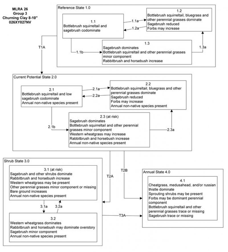
Reference State 1.0:
The Reference State 1.0 is representative of the natural range of variability under pristine conditions. The reference state has three general community phases: a shrub-grass dominant phase, a perennial grass dominant phase and a shrub dominant phase. State dynamics are maintained by interactions between climatic patterns and disturbance regimes. Negative feedbacks enhance ecosystem resilience and contribute to the stability of the state. These include the presence of all structural and functional groups, low fine fuel loads, and retention of organic matter and nutrients. Plant community phase changes are primarily driven by fire, periodic drought and/or insect or disease attack.
Community Phase 1.1:
This community is dominated by low sagebrush, bottlebrush squirreltail and Sandberg bluegrass. Forbs and other grasses make up smaller components.
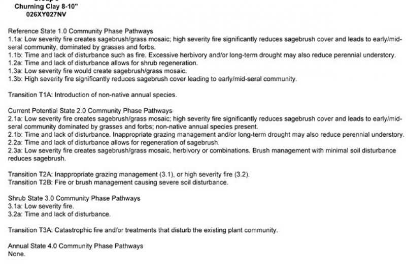
Community Phase Pathway 1.1a, from Phase 1.1 to 1.2:
Fire will decrease or eliminate the overstory of sagebrush and allow for the perennial bunchgrasses to dominate the site. Fires will typically be low severity resulting in a mosaic pattern due to low fuel loads. A fire following an unusually wet spring may be more severe and reduce sagebrush cover to trace amounts.
Community Phase Pathway 1.1b, from Phase 1.1 to 1.3:
Time and lack of disturbance such as fire allows for sagebrush to increase and become decadent. Long-term drought, herbivory, or combinations of these will cause a decline in perennial bunchgrasses and fine fuels leading to a reduced fire frequency and allowing sagebrush to dominate the site.
Community Phase 1.2:
This community phase is characteristic of a post-disturbance, early/mid-seral community. Bottlebrush squirreltail, Sandberg bluegrass and other perennial bunchgrasses dominate. Depending on fire severity patches of intact sagebrush may remain. Rabbitbrush and other sprouting shrubs may be sprouting. Perennial forbs may be a significant component for a number of years following fire.
Community Phase Pathway 1.2a, from Phase 1.2 to 1.1:
Time and lack of disturbance will allow sagebrush to increase.
Community Phase 1.3:
Sagebrush increases in the absence of disturbance. Decadent sagebrush dominates the overstory and the deep-rooted perennial bunchgrasses in the understory are reduced either from competition with shrubs and/or from herbivory.
Community Phase Pathway 1.3a, from Phase 1.3 to 1.2:
Fire will decrease or eliminate the overstory of sagebrush and allow for the perennial bunchgrasses to dominate the site. Fires may be high severity in this community phase due to the dominance of sagebrush resulting in removal of overstory shrub community.
T1A: Transition from the Reference State 1.0 to Current Potential State 2.0:
Trigger: This transition is caused by the introduction of non-native annual plants, such as cheatgrass, mustards, and bur buttercup (Ceratocephala testiculata).
Slow variables: Over time the annual non-native species will increase within the community.
Threshold: Any amount of introduced non-native species causes an immediate decrease in the resilience of the site. Annual non-native species cannot be easily removed from the system and have the potential to significantly alter disturbance regimes from their historic range of variation.
Current Potential State 2.0:
This state is similar to the Reference State 1.0. Ecological function has not changed, however, the resiliency of the state has been reduced by the presence of invasive weeds. This state has the same three general community phases. These non-native species can be highly flammable, and promote fire where historically fire had been infrequent. Negative feedbacks enhance ecosystem resilience and contribute to the stability of the state. These feedbacks include the presence of all structural and functional groups, low fine fuel loads, and retention of organic matter and nutrients. Positive feedbacks decrease ecosystem resilience and stability of the state. These include the non-natives’ high seed output, persistent seed bank, rapid growth rate, ability to cross pollinate, and adaptations for seed dispersal.
Community Phase 2.1:
This community phase is similar to the Reference State Community Phase 1.1, with the presence of non-native species in trace amounts. Sagebrush, bottlebrush squirreltail and Sandberg bluegrass dominate the site. Forbs and other shrubs and grasses make up smaller components of this site.
Community Phase Pathway 2.1a, from Phase 2.1 to 2.2:
Fire reduces the shrub overstory and allows for perennial bunchgrasses to dominate the site. Fires are typically low severity resulting in a mosaic pattern due to low fuel loads. A fire following an unusually wet spring or a change in management favoring an increase in fine fuels may be more severe and reduce sagebrush cover to trace amounts. Annual non-native species are likely to increase after fire.
Community Phase Pathway 2.1b, from Phase 2.1 to 2.3:
Time and lack of disturbance allows for sagebrush to increase and become decadent. Long-term drought reduces fine fuels and leads to a reduced fire frequency, allowing sagebrush to dominate the site. Inappropriate grazing management reduces the perennial grass understory.
Community Phase 2.2:
This community phase is characteristic of a post-disturbance, early to mid-seral community where annual non-native species are present. Sagebrush is present in trace amounts; bottlebrush squirreltail, Sandberg bluegrass and other perennial bunchgrasses dominate the site. Depending on fire severity patches of intact sagebrush may remain. Rabbitbrush may be sprouting or dominant in the community. Perennial forbs may be a significant component for a number of years following fire. Annual non-native species are stable or increasing within the community.
Community Phase Pathway 2.2a, from Phase 2.2 to 2.1:
Time and lack of disturbance and/or grazing management that favors the establishment and growth of sagebrush allows the shrub component to recover. The establishment of low sagebrush can take many years.
Community Phase 2.3 (At Risk):
This community is at risk of crossing a threshold to another state. Sagebrush dominates the overstory and perennial bunchgrasses in the understory are reduced, either from competition with shrubs, from inappropriate grazing, or from both. Rabbitbrush may be a significant component. Bare ground increases. Annual non-native species may be stable or increasing due to lack of competition with perennial bunchgrasses. Pinyon and/or juniper may be present. This site is susceptible to further degradation from grazing, drought, and fire.
Community Phase Pathway 2.3a, from Phase 2.3 to 2.2:
Fire eliminates/reduces the overstory of sagebrush and allows for the understory perennial grasses to increase. Fires may be high severity in this community phase due to the dominance of sagebrush resulting in removal of overstory shrub community. Annual non-native species respond well to fire and may increase post burn.
T2A: Transition from Current Potential State 2.0 to Shrub State 3.0:
Trigger: To Community Phase 3.1: Inappropriate grazing will decrease or eliminate deep rooted perennial bunchgrasses, increase Sandberg bluegrass and favor shrub growth and establishment. To Community Phase 3.2: Severe fire in Community Phase 2.3 will remove sagebrush overstory. Annual non-native species will increase.
Slow variables: Long term decrease in deep-rooted perennial grass density.
Threshold: Loss of deep-rooted perennial bunchgrasses changes nutrient cycling, nutrient redistribution, and reduces soil organic matter.
T2B: Transition from Current Potential State 2.0 to Annual State 4.0:
Trigger: Fire or soil disturbing treatment would transition to Community Phase 4.1.
Slow variables: Increased production and cover of non-native annual species.
Threshold: Loss of deep-rooted perennial bunchgrasses and shrubs changes temporal and spatial nutrient capture and cycling within the community. Increased, continuous fine fuels modify the fire regime by increasing frequency, size and spatial variability of fires.
Shrub State 3.0:
This state has two community phases, a shrub-dominated phase and a grass-dominated phase. This state is a product of many years of heavy grazing during time periods harmful to perennial bunchgrasses. Sagebrush dominates the overstory and rabbitbrush may be a significant component. Sagebrush cover exceeds site concept and may be decadent, reflecting stand maturity and lack of seedling establishment due to competition with mature plants. The shrub overstory and bottlebrush squirreltail or western wheatgrass understory dominate site resources such that soil water, nutrient capture, nutrient cycling and soil organic matter are temporally and spatially redistributed.
Community Phase 3.1 (At Risk):
Decadent sagebrush dominates the overstory. Rabbitbrush may be a significant component. Deep-rooted perennial bunchgrasses may be present in trace amounts or absent from the community. Western wheatgrass and annual non-native species increase. Bare ground is significant. Pinyon and/or juniper may be present.
Community Phase Pathway 3.1a, from Phase 3.1 to 3.2:
Fire, heavy fall grazing causing mechanical damage to shrubs, and/or brush treatments with minimal soil disturbance, will greatly reduce the overstory shrubs to trace amounts and allow grasses to dominate the site.
Community Phase 3.2:
Bottlebrush squirreltail and/or western wheatgrass dominate the site; annual non-native species may be present but are not dominant. Trace amounts of sagebrush or rabbitbrush may be present. Bare ground may be significant.
Community Phase Pathway 3.2a, from Phase 3.2 to 3.1:
Time and lack of disturbance and/or grazing management that favors the establishment and growth of sagebrush allows the shrub component to recover. The establishment of low sagebrush can take many years.
T3A: Transition from Shrub State 3.0 to Annual State 4.0:
Trigger: Fire and/or treatments that disturb the soil and existing plant community.
Slow variables: Increased seed production (following a wet spring) and cover of annual non-native species.
Threshold: Increased, continuous fine fuels modify the fire regime by changing frequency, intensity, size and spatial variability of fires. Changes in plant community composition and spatial variability of vegetation due to the loss of perennial bunchgrasses and sagebrush truncate energy capture and impact the temporal and spatial aspects of nutrient cycling and distribution.
Annual State 4.0:
This state has one community phase dominated by annual plants. An abiotic threshold has been crossed and state dynamics are driven by fire and time. The herbaceous understory is dominated by annual non-native species such as cheatgrass, medusahead, Russian thistle, and mustards. Resiliency has declined and further degradation from fire facilitates a cheatgrass and sprouting shrub plant community. Fire return interval has shortened due to the dominance of annual grasses in the understory and is a driver in site dynamics.
Community Phase 4.1:
Annual plants like cheatgrass, medusahead, and Russian thistle dominate. Bottlebrush squirreltail and perennial forbs may still be present in trace amounts. Surface erosion may increase with summer convection storms and would be evidenced by increased pedestalling of plants, rill formation, or extensive water flow paths.
The reference plant community is dominated by low sagebrush, bottlebrush squirreltail, and Sandberg's bluegrass. Potential vegetative composition is about 60% grasses, 10% forbs and 30% shrubs. Approximate ground cover (basal and crown) is 15 to 25 percent.
Figure 5. Annual production by plant type (representative values) or group (midpoint values)
Table 5. Annual production by plant type
Plant type
Low (lb/acre)
Representative value (lb/acre)
High (lb/acre)
Grass/Grasslike
150
180
240
Shrub/Vine
75
90
120
Forb
25
30
40
Total
250
300
400
Additional community tables
Table 6. Community 1.1 plant community composition
Livestock Interpretations:
This site is suited to livestock grazing. Grazing management should be keyed to bottlebrush squirreltail and Sandberg bluegrass production. Domestic sheep and to a much lesser degree cattle consume low sagebrush, particularly during the spring, fall and winter. Bluegrass is a widespread forage grass. It is one of the earliest grasses in the spring and is sought by domestic livestock and several wildlife species. Sandberg bluegrass is a palatable species, but its production is closely tied to weather conditions. It produces little forage in drought years, making it a less dependable food source than other perennial bunchgrasses.
Stocking rates vary over time depending upon season of use, climate variations, site, and previous and current management goals. A safe starting stocking rate is an estimated stocking rate that is fine tuned by the client by adaptive management through the year and from year to year.
Wildlife Interpretations:
Low sagebrush is considered a valuable browse plant during the spring, fall and winter months. In some areas it is of little value in winter due to heavy snow. Mule deer utilize and sometimes prefer low sagebrush, particularly in winter and early spring.
Sagebrush-grassland communities provide critical sage-grouse breeding and nesting habitats. Sagebrush is a crucial component of their diet year-round, and sage-grouse select sagebrush almost exclusively for cover. Leks are often located on low sagebrush sites, grassy openings, dry meadows, ridgetops, and disturbed sites. Bottlebrush squirreltail and Sandberg's bluegrass are important forage species for several wildlife species.
Hydrological functions
Rills and water flow patterns are rare. Pedestals formed due to erosion are rare. Pedestals formed due to shrink-swell soil activity are commonly associated with bunch grasses. Frost heaving and shrink-swell soil activity that affects shallow rooted plants are not indicators of soil erosion. Gullies are none to very rare in areas of this site that occur on stable landforms. Runoff is low to very low and ponding occurs in many areas. Shallow-rooted perennial grass plants [i.e., bottlebrush squirreltail & Sandberg's bluegrass] and perennial forbs having thick tap roots can slow runoff. Infiltration is slow to very slow once the surface soil is wetted. Shrub canopy and associated litter break raindrop impact and provide opportunity for snow catch and accumulation on site.
Recreational uses
Aesthetic value is derived from the diverse floral and faunal composition and the colorful flowering of wild flowers and shrubs during the spring and early summer. This site is used for camping and hiking and has potential for upland and big game hunting.
Other information
Low sagebrush can be successfully transplanted or seeded in restoration.
Supporting information
Type locality
Location 1: Carson City County, NV
General legal description
This site occurs in Carson City, Douglas, Lyon, Mineral, Storey, and Washoe Counties, Nevada.
Interpreting Indicators of Rangeland Health is a qualitative assessment protocol used to
determine ecosystem condition based on benchmark characteristics described in the Reference Sheet. A suite of 17 (or
more) indicators are typically considered in an assessment. The ecological site(s) representative of an assessment
location must be known prior to applying the protocol and must be verified based on soils and climate. Current plant
community cannot be used to identify the ecological site.
Author(s)/participant(s)
GK BRACKLEY
Contact for lead author
State Rangeland Management Specialist
Date
06/20/2006
Approved by
Kendra Moseley
Approval date
Composition (Indicators 10 and 12) based on
Annual Production
Indicators
Number and extent of rills:
Rills are rare.
Presence of water flow patterns:
Water flow patterns are rare.
Number and height of erosional pedestals or terracettes:
Pedestals formed due to erosion are rare. Pedestals formed due to shrink-swell soil activity are commonly associated with bunch grasses. Frost heaving and shrink-swell soil activity that affects shallow rooted plants are not indicators of soil erosion.
Bare ground from Ecological Site Description or other studies (rock, litter, lichen, moss, plant canopy are
not bare ground):
Bare ground 50 to 65%; surface rock fragments ±15%; shrub canopy 15 to 25%; basal area for perennial herbaceous plants about 5%.
Number of gullies and erosion associated with gullies:
Gullies are none to very rare in areas of this site that occur on stable landforms.
Extent of wind scoured, blowouts and/or depositional areas:
None
Amount of litter movement (describe size and distance expected to travel):
Fine litter (foliage from grasses and annual & perennial forbs) is expected to move the distance of slope length during intense summer convection storms or rapid snowmelt events. Persistent litter (large woody material) will remain in place except during catastrophic events.
Soil surface (top few mm) resistance to erosion (stability values are averages - most sites will show a range
of values):
Soil stability values should be 4 to 6 on the heavy clay surface soil textures found on this site. (To be field tested.)
Soil surface structure and SOM content (include type of structure and A-horizon color and thickness):
Surface structure is typically granular at the immediate surface grading to platy or massive below. Soil surface colors are light and soils are typified by an ochric epipedon. Organic carbon of the surface 2 to 3 inches is typically less than 1.5 percent.
Effect of community phase composition (relative proportion of different functional groups) and spatial
distribution on infiltration and runoff:
Runoff is slow to very slow and ponding occurs in many areas. Shallow-rooted perennial grass plants [i.e., bottlebrush squirreltail & Sandberg bluegrass] and perennial forbs having thick tap roots can slow runoff. Infiltration is slow to very slow once the surface soil is wetted. Shrub canopy and associated litter break raindrop impact and provide opportunity for snow catch and accumulation on site.
Presence and thickness of compaction layer (usually none; describe soil profile features which may be
mistaken for compaction on this site):
Compacted layers are not typical. Platy or massive sub-surface horizons and heavy clay surface soils are not to be interpreted as compacted layers.
Functional/Structural Groups (list in order of descending dominance by above-ground annual-production or live foliar
cover using symbols: >>, >, = to indicate much greater than, greater than, and equal to):
Amount of plant mortality and decadence (include which functional groups are expected to show mortality or
decadence):
Dead branches within individual shrubs is somewhat common and standing dead shrub canopy material may be as much as 15% of total woody canopy; some of the mature bunchgrasses (<10%) have dead centers.
Average percent litter cover (%) and depth ( in):
Between plant interspaces (<5%) and litter depth is <¼ inch.
Expected annual annual-production (this is TOTAL above-ground annual-production, not just forage annual-production):
For normal or average growing season (through May) ± 300lbs/ac; Spring moisture significantly affects total production.
Potential invasive (including noxious) species (native and non-native). List species which BOTH characterize
degraded states and have the potential to become a dominant or co-dominant species on the ecological site if
their future establishment and growth is not actively controlled by management interventions. Species that become
dominant for only one to several years (e.g., short-term response to drought or wildfire) are not invasive
plants. Note that unlike other indicators, we are describing what is NOT expected in the reference state for the
ecological site:
Cheatgrass and other annual bromegrasses, medusahead, Russian thistle, and annual mustards are invaders on this site. Douglas rabbitbrush is an increaser on this site.
Perennial plant reproductive capability:
All functional groups should reproduce in average (or normal) and above average growing season years.
The Ecosystem Dynamics Interpretive Tool is an information system framework developed by the USDA-ARS Jornada Experimental Range, USDA Natural Resources Conservation Service, and New Mexico State University.
Click on box and path labels to scroll to the respective text.