Ecological dynamics
As ecological condition declines, perennial grasses and fourwing saltbush decrease. Species most likely to invade this site are annuals.
Fire Ecology:
Grassland communities with a basin wildrye component historically experienced mostly infrequent to frequent stand replacing fires. Grassland vegetation types experienced both short fire intervals of less than 35 years as well as intervals ranging from 35 to 100 years, depending on climate and ignition sources.
Basin wildrye is top-killed by fire. Older basin wildrye plants with large proportions of dead material within the perennial crown can be expected to show higher mortality due to fire than younger plants having little debris. Basin wildrye is generally tolerant of fire but may be damaged by early season fire combined with dry soil conditions.
Fourwing saltbush is most common under regimes of infrequent fire and moderate browsing. Fire top-kills or kills fourwing saltbush, depending upon ecotype. Fourwing saltbush may sprout after top-kill.
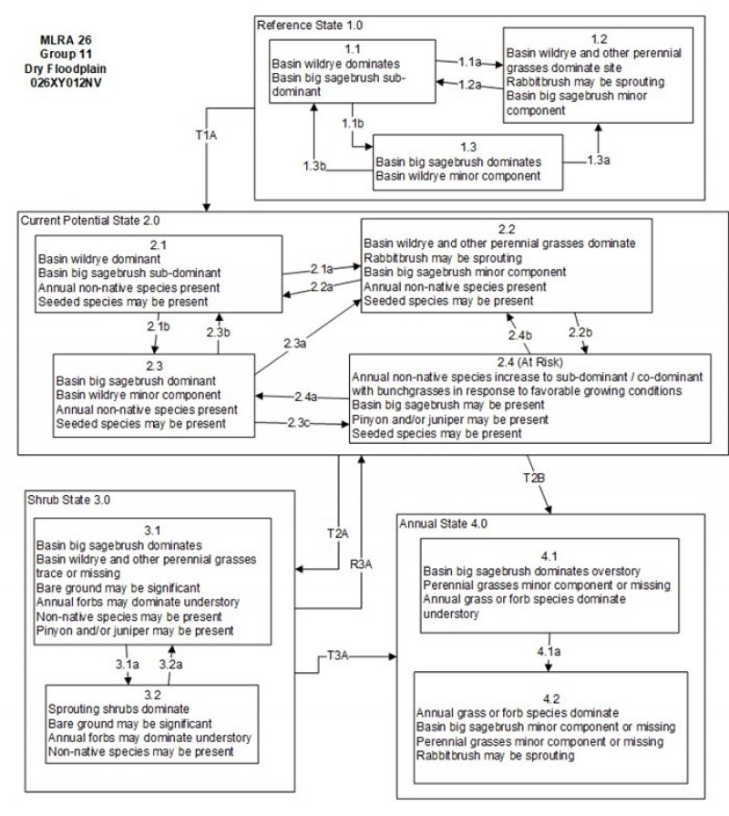
State and Transition Model Narrative for Group 11
This is a text description of the states, phases, transitions, and community pathways possible in the State and Transition model for the MLRA 26 Disturbance Response Group 11. Additional sites included in the group are R026XY012NV and R026XY034NV.
Reference State 1.0:
The Reference State 1.0 is a representation of the natural range of variability under pristine conditions. The reference state has three general community phases: a shrub-grass dominant phase, a perennial grass dominant phase, and a shrub dominant phase. State dynamics are maintained by interactions between climatic patterns and disturbance regimes. Negative feedbacks enhance ecosystem resilience and contribute to the stability of the state. These include the presence of all structural and functional groups, low fine fuel loads, and retention of organic matter and nutrients. Plant community phase changes are primarily driven by fire, periodic drought and/or insect or disease attack.
Community Phase 1.1:
Basin wildrye and basin big sagebrush dominate the plant community. Forbs and other grasses make up smaller components.
Community Phase Pathway 1.1a, from phase 1.1 to 1.2:
Fire would decrease or eliminate the overstory of sagebrush and allow the perennial bunchgrasses and forbs to dominate the site. Fires would typically be small and patchy due to low or moist fuel loads.
Community Phase Pathway 1.1b, from phase 1.1 to 1.3:
Time and lack of disturbance such as fire allows sagebrush to increase and become dominant. Long-term drought, herbivory, or combinations of these would cause a decline in basin wildrye and fine fuels, leading to a reduced fire frequency allowing big sagebrush to dominate the site.
Community Phase 1.2:
This community phase is characteristic of a post-disturbance, early- to mid-seral community. Basin wildrye, western wheatgrass, and other perennial bunchgrasses dominate. Depending on fire severity or intensity of Aroga moth infestation, patches of intact sagebrush may remain. Rabbitbrush may be sprouting and may be a significant component of the plant community.
Community Phase Pathway 1.2a, from phase 1.2 to 1.1:
Time and lack of disturbance allows sagebrush to reestablish.
Community Phase 1.3:
Big sagebrush dominates in the absence of disturbance. Mature sagebrush may be decadent. The deep-rooted perennial bunchgrasses in the understory are reduced either from competition with shrubs and/or from herbivory. Basin wildrye is a minor component.
Community Phase Pathway 1.3a, from phase 1.3 to 1.2:
Fire would decrease or eliminate the overstory of sagebrush and allow the perennial bunchgrasses to dominate the site. Fires would typically be low severity resulting in a mosaic pattern due to low fine fuel loads. A fire following an unusually wet spring or a change in management favoring an increase in fine fuels, may be more severe and reduce sagebrush cover to trace amounts. A severe infestation of Aroga moth could also cause a large decrease in sagebrush within the community, giving a competitive advantage to the perennial grasses and forbs.
Community Phase Pathway 1.3b, from phase 1.3 to 1.1:
Low severity fire, Aroga moth, or a combination of both will reduce some of the sagebrush overstory and allow grass species to increase.
T1A: Transition from Reference State 1.0 to Current Potential State 2.0:
Trigger: This transition is caused by the introduction of non-native annual weeds, such as cheatgrass, mustard and Russian thistle.
Slow variables: Over time, the annual non-native plants will increase within the community.
Threshold: Any amount of introduced non-native species causes an immediate decrease in the resilience of the site. Annual non-native species cannot be easily removed from the system and have the potential to significantly alter disturbance regimes from their historic range of variation.
Current Potential State 2.0:
This state is similar to the Reference State 1.0 with the addition of one community phase. Ecological function has not changed, however the resiliency of the state has been reduced by the presence of invasive weeds. This state has the same three general community phases. Negative feedbacks enhance ecosystem resilience and contribute to the stability of the state. These include the presence of all structural and functional groups, low fine fuel loads and retention of organic matter and nutrients. Positive feedbacks decrease ecosystem resilience and stability of the state. These include the non-natives high seed output, persistent seed bank, rapid growth rate, ability to cross pollinate and adaptations for seed dispersal. Additionally, the presence of highly flammable non-native species reduces State resilience because these species can promote fire where historically fire has been infrequent leading to positive feedbacks that further the degradation of the system. Seeded species may be present in all phases of this group. This site was not seen in a seeded state, however crested wheatgrass was found, likely from nearby seedings.
Community Phase 2.1:
This community phase is similar to Reference State Community Phase 1.1, with the presence of non-native annual species present. Basin wildrye and basin big sagebrush dominate the plant community. Forbs and other grasses make up smaller components.
Community Phase Pathway 2.1a, from phase 2.1 to 2.2:
Fire would decrease or eliminate the overstory of sagebrush and allow the perennial bunchgrasses and forbs to dominate the site. Fires would typically be small and patchy due to low or moist fuel loads.
Community Phase Pathway 2.1b, from phase 2.1 to 2.3:
Time without disturbance, long-term drought, grazing management that favors shrubs, or combinations of these would allow the sagebrush overstory to increase and dominate the site.
Community Phase 2.2:
This community phase is characteristic of a post-disturbance, early- to mid-seral community. Basin wildrye, western wheatgrass, and other perennial bunchgrasses dominate. Depending on fire severity or intensity of Aroga moth infestation, patches of intact sagebrush may remain. Rabbitbrush may be sprouting and may be a significant component of the plant community. Annual non-native species are stable or increasing within the community.
Community Phase Pathway 2.2a, from phase 2.2 to 2.1:
Absence of disturbance over time allows sagebrush to recover. This may be combined with grazing management that favors shrubs.
Community Phase Pathway 2.2b, from phase 2.2. to 2.4:
Fall and spring growing conditions that favor the germination and production of non-native, annual grasses cause these species to codominate with bunchgrasses in the understory. This pathway typically occurs three to five years post fire and phase 2.4 may be a transitory plant community.
Community Phase 2.3:
Big sagebrush dominates in the absence of disturbance. Mature sagebrush may be decadent. The deep-rooted perennial bunchgrasses in the understory are reduced either from competition with shrubs and/or from herbivory. Basin wildrye is a minor component. Rabbitbrush may be a significant component. Annual non-natives species may be stable or increasing due to lack of competition with perennial bunchgrasses. This site is susceptible to further degradation from grazing, drought, and fire.
Community Phase Pathway 2.3a, from phase 2.3 to 2.2:
Fire would decrease or eliminate the overstory of sagebrush and allow the perennial bunchgrasses to dominate the site. Fires would typically be low severity resulting in a mosaic pattern due to low fine fuel loads. A fire following an unusually wet spring or a change in management favoring an increase in fine fuels, may be more severe and reduce sagebrush cover to trace amounts. A severe infestation of Aroga moth could also cause a large decrease in sagebrush within the community, giving a competitive advantage to the perennial grasses and forbs. Annual non-native species respond well to fire and may increase post-burn. Brush management with minimal soil disturbance and/or late-fall/winter grazing that causes mechanical damage to sagebrush may also cause this change.
Community Phase Pathway 2.3b, from phase 2.3 to 2.1:
A change in grazing management that decreases shrubs will allow for the perennial bunchgrasses in the understory to increase. Heavy late-fall/winter grazing will reduce sagebrush and increase the herbaceous understory. A moderate infestation of Aroga moth may reduce some sagebrush overstory and allow perennial grasses to increase in the community. Brush treatments with minimal soil disturbance will also decrease sagebrush and release the perennial understory. Annual non-native species are present in the community.
Community Phase Pathway 2.3c, from phase 2.3 to 2.4:
Fall and spring growing season conditions that favor the germination and production of non-native annual grasses cause these species to become dominant. This phase may be a transitory plant community.
Community Phase 2.4:
This community is at risk of crossing to an annual state. Native bunchgrasses and forbs still comprise 50% or more of the understory annual production, however, non-native annual grasses are nearly codominant. If this site originated from phase 2.3 there may be significant shrub cover as well. Annual production and abundance of these annuals may increase drastically in years with heavy spring precipitation. Seeded species may be present. This site is susceptible to further degradation from grazing, drought and fire.
Community Phase Pathway 2.4a, from phase 2.4 to 2.3:
Growing season conditions that favor perennial bunchgrass production and reduce cheatgrass production.
Community Phase Pathway 2.4b, from phase 2.4 to 2.2:
Growing season conditions that favor perennial bunchgrass production and reduce cheatgrass production. May occur as site recovers from fire.
T2A: Transition from Current Potential State 2.0 to Shrub State 3.0:
Trigger: Inappropriate, long-term grazing of perennial bunchgrasses during growing season favors shrubs and initiates the transition to Phase 3.1 from Phase 2.3. May be exacerbated by a lowered seasonal water table. Fire causes a transition to Community Phase 3.2.
Slow variables: Long term reduction in deep-rooted perennial grass density results in a decrease in organic matter inputs and subsequent soil water decline.
Threshold: Loss of deep-rooted perennial bunchgrasses spatially and temporally changes nutrient cycling and redistribution, and reduces soil organic matter. Loss of high seasonal water table prevents regeneration of basin wildrye.
T2B: Transition from Current Potential State 2.0 to Annual State 4.0:
Trigger: Severe fire or multiple fires, long term inappropriate grazing, and/or soil disturbing treatments such as plowing.
Slow variables: Increased production and cover of non-native annual species.
Threshold: Loss of deep-rooted perennial bunchgrasses and shrubs truncates, spatially and temporally, nutrient capture and cycling within the community. Increased, continuous fine fuels from annual non-native plants modify the fire regime by changing intensity, size and spatial variability of fires.
Shrub State 3.0:
This state is a product of many years of heavy grazing during time periods harmful to perennial bunchgrasses. Sagebrush dominates the overstory and rabbitbrush may be a significant component. Sagebrush cover exceeds site concept and may be decadent, reflecting stand maturity and lack of seedling establishment due to competition with mature plants. The shrub overstory dominates site resources such that soil water, nutrient capture, nutrient cycling and soil organic matter are temporally and spatially redistributed.
Community Phase 3.1:
Sagebrush and/or rabbitbrush dominates the overstory and other shrubs may be a significant component. Perennial bunchgrasses are a minor component. Annual non-native species are present to increasing. Understory may be sparse, with bare ground increasing.
Community Phase Pathway 3.1a, from phase 3.1 to 3.2:
Fire or heavy fall grazing reduces or eliminates the overstory of sagebrush to trace amounts and allows bunchgrasses to dominate the site. Brush treatments causing minimal soil disturbance causing mechanical damage to shrubs may also cause this change.
Community Phase 3.2:
Rabbitbrush dominates the overstory. Annual non-native species may be present in the understory but are not dominant. Perennial bunchgrasses may be a minor component. Bare ground may be increasing.
Community Phase Pathway 3.2a, from phase 3.2 to 3.1:
Time and lack of disturbance over time and/or grazing management that favors the establishment and growth of sagebrush allows sagebrush to recover.
T3A: Transition from Shrub State 3.0 to Annual State 4.0:
Trigger: Fire or inappropriate grazing management can eliminate the perennial community and transition to community phase 4.1 or 4.2. This may be coupled with gullying and loss of seasonally high water table that maintains basin wildrye.
Slow variable: Increased seed production and cover of annual non-native species.
Threshold: Increased, continuous fine fuels modify the fire regime by changing intensity, size and spatial variability of fires. Changes in plant community composition and spatial variability of vegetation due to the loss of perennial bunchgrasses and sagebrush truncate energy capture and impact the nutrient cycling and distribution.
R3A: Restoration from Shrub State 3.0 to Current Potential State 2.0:
Brush management coupled with seeding of desired perennial bunchgrass. Concurrent herbicide treatment may be needed to avoid an increase in annual invasive species. If changes in vegetation were caused by altered hydrology, restoration of associated channels will be needed to achieve success.
Annual State 4.0:
An abiotic threshold has been crossed and state dynamics are driven by fire and time. The herbaceous understory is dominated by annual non-native species such as cheatgrass and mustards. Resiliency has declined and further degradation from fire facilitates a cheatgrass and sprouting shrub plant community. Fire return interval has shortened due to the dominance of cheatgrass in the understory and is a driver in site dynamics.
Community Phase 4.1:
Big sagebrush dominates the overstory, with non-native annual grasses and forb species in the understory. Perennial grasses are a minor component and may be missing entirely.
Community Phase pathway 4.1a, from phase 4.1 to 4.2:
Fire and/or a failed brush treatment or seeding eliminates the shrub overstory. Annuals such as cheatgrass increase after fire and dominate the site.
Community Phase 4.2:
Annual non-native plants such as cheatgrass dominate the site. This phase may have seeded species present if resulting from a failed seeding attempt. Perennial bunchgrasses and forbs may still be present in trace amounts. Rabbitbrush may be sprouting Surface erosion may increase with summer convection storms; increased pedestalling of plants, rill formation, or extensive water flow paths identify these events.
Community 1.1
Reference Plant Community
The reference plant community is dominated by basin wildrye, fourwing saltbush and Torrey's quailbush. Potential vegetative composition is about 65% grasses, 5% forbs and 30% shrubs.
Table 5. Annual production by plant type
| Plant type |
Low
(lb/acre) |
Representative value
(lb/acre) |
High
(lb/acre) |
| Grass/Grasslike |
585 |
780 |
975 |
| Shrub/Vine |
270 |
360 |
450 |
| Forb |
45 |
60 |
75 |
| Total |
900 |
1200 |
1500 |