Ecological dynamics
As ecological condition declines, perennial grasses decline while Douglas' rabbitbrush, littleleaf horsebrush, and Lahontan sagebrush become more dominant Species most likely to invade this site are non-native annual forbs and grasses.
Fire Ecology:
The mean fire return interval for Lahontan sagebrush communities have been estimated to be from 35 to over 100 years. Fire most often occurs during wet years with high forage production. Lahontan sagebrush is very susceptible to fire damage. Lahontan sagebrush is usually killed by fire and does not re-sprout. The recovery in burned areas is usually via small, light, wind-dispersed seed for all low sagebrush subspecies. Partially injured Lahontan sagebrush may re-grow from living branches, but sprouting does not occur.
Desert needlegrass has persistent dead leaf bases, which make it susceptible to burning. Fire removes the accumulation; a rapid, cool fire will not burn deep into the root crown.
Bottlebrush squirreltail's small size, coarse stems, and sparse leafy material aid in its tolerance of fire. Postfire regeneration occurs from surviving root crowns and from on- and off-site seed sources. Frequency of disturbance greatly influences postfire response of bottlebrush squirreltail. Undisturbed plants within a 6 to 9 year age class generally contain large amounts of dead material, increasing bottlebrush squirreltail's susceptibility to fire.
Sandberg bluegrass is generally unharmed by fire. It produces little litter, and its small bunch size and sparse litter reduces the amount of heat transferred to perennating buds in the soil. Its rapid maturation in the spring also reduces fire damage, since it is dormant when most fires occur.
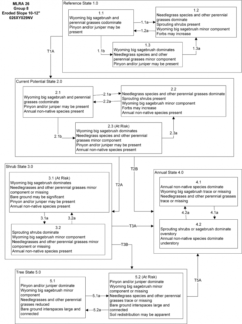
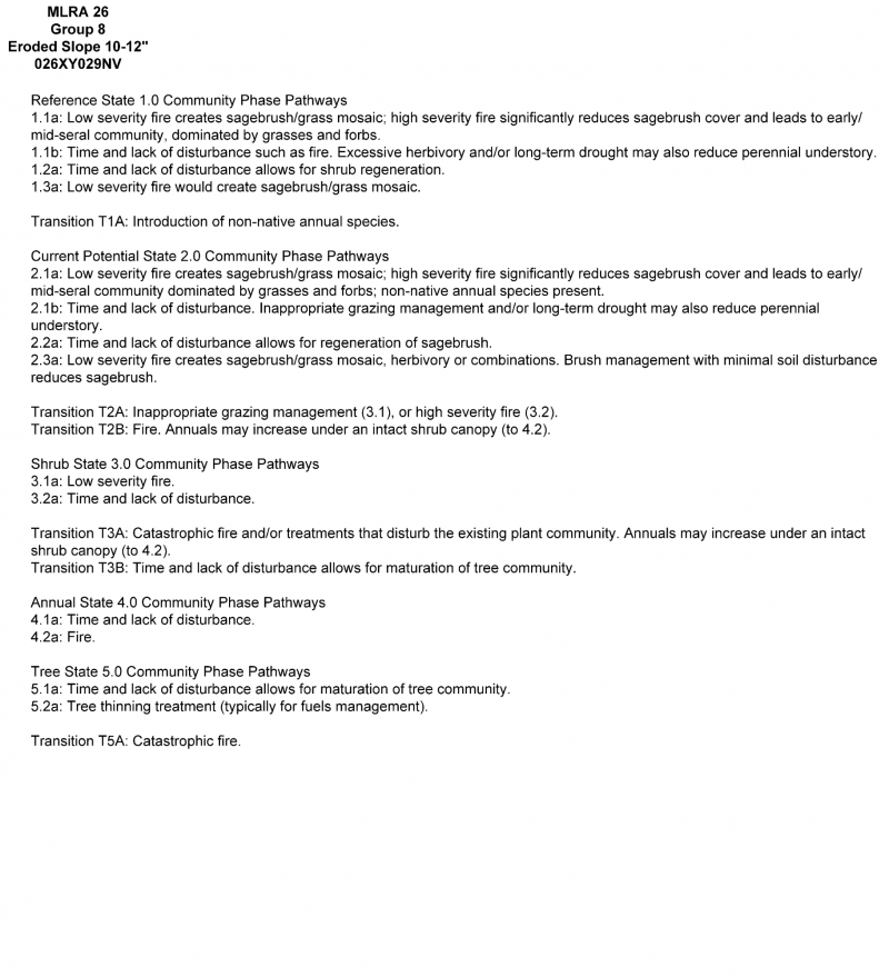
State and Transition Model Narrative Group 8
This is a text description of the states, phases, transitions, and community pathways possible in the State and Transition model for the MLRA 26 Disturbance Response Group 8.
Reference State 1.0:
The Reference State 1.0 is a representative of the natural range of variability under pristine conditions. The reference state has three general community phases; a shrub-grass dominant phase, a perennial grass dominant phase and a shrub dominant phase. State dynamics are maintained by interactions between climatic patterns and disturbance regimes. Negative feedbacks enhance ecosystem resilience and contribute to the stability of the state. These include the presence of all structural and functional groups, low fine fuel loads, and retention of organic matter and nutrients. Plant community phase changes are primarily driven by fire, periodic drought and/or insect or disease attack.
Community Phase 1.1:
Wyoming big sagebrush, Thurber’s needlegrass, desert needlegrass, bottlebrush squirreltail and Indian ricegrass dominate the site. Douglas rabbitbrush, purple sage and antelope bitterbrush are also common on this site. Utah juniper and singleleaf pinyon are described in the site concept and may be present in minor amounts.
Community Phase Pathway 1.1a, from Phase 1.1 to 1.2:
Fire would decrease or eliminate the overstory of sagebrush and allow for the perennial bunchgrasses to dominate the site. Fires would typically be small and patchy due to low fuel loads. A fire following an unusually wet spring or a change in management may be more severe and reduce sagebrush cover to trace amounts. A severe infestation of Aroga moth could also cause a large decrease in sagebrush within the community, giving a competitive advantage to the perennial grasses and forbs.
Community Phase Pathway 1.1b, Phase 1.1 to 1.3:
Long-term drought, time and/or herbivory favor an increase in Wyoming big sagebrush over deep-rooted perennial bunchgrasses. Combinations of these would allow the sagebrush overstory to increase and dominate the site, causing a reduction in the perennial bunchgrasses.
Community Phase 1.2:
This community phase is characteristic of a post-disturbance, early to mid-seral community phase. Thurber’s needlegrass, desert needlegrass, bottlebrush squirreltail, Indian ricegrass and other perennial grasses are common. Sprouting shrubs are present. Wyoming big sagebrush is killed by fire, therefore decreasing within the burned community. Sagebrush could still be present in unburned patches. Needlegrasses can experience high mortality from fire and may be reduced in the community for several years.
Community Phase Pathway 1.2a, Phase 1.2 to 1.1:
Time and lack of disturbance allows for sagebrush to reestablish.
Community Phase 1.3:
Wyoming big sagebrush increases in the absence of disturbance. Decadent sagebrush dominates the overstory and the deep-rooted perennial bunchgrasses in the understory are reduced either from competition with shrubs or from herbivory. Squirreltail will likely increase in the understory and may be the dominant grass on the site.
Community Phase Pathway 1.3a, from Phase 1.3 to 1.2:
Fire would decrease or eliminate the overstory of sagebrush and allow for the perennial bunchgrasses to dominate the site. Fires would typically be small and patchy due to low fuel loads. A fire following an unusually wet spring or a change in management may be more severe and reduce sagebrush cover to trace amounts. A severe infestation of Aroga moth could also cause a large decrease in sagebrush within the community, giving a competitive advantage to the perennial grasses and forbs.
T1A: Transition from Reference State 1.0 to Current Potential State 2.0:
Trigger: This transition is caused by the introduction of non-native annual weeds, such as cheatgrass and mustards.
Slow variables: Over time the annual non-native plants will increase within the community decreasing organic matter inputs from deep-rooted perennial bunchgrasses resulting in reductions in soil water availability for perennial bunchgrasses.
Threshold: Any amount of introduced non-native species causes an immediate decrease in the resilience of the site. Annual non-native species cannot be easily removed from the system and have the potential to significantly alter disturbance regimes from their historic range of variation.
Current Potential State 2.0:
This state is similar to the Reference State 1.0. Ecological function has not changed, however the resiliency of the state has been reduced by the presence of invasive weeds. This state has the same three general community phases. Negative feedbacks enhance ecosystem resilience and contribute to the stability of the state. These include the presence of all structural and functional groups, low fine fuel loads and retention of organic matter and nutrients. Positive feedbacks decrease ecosystem resilience and stability of the state. These include the non-natives high seed output, persistent seed bank, rapid growth rate, ability to cross-pollinate and adaptations for seed dispersal. Additionally, the presence of highly flammable, non-native species reduces state resilience because these species can promote fire where historically fire has been infrequent leading to positive feedbacks that further the degradation of the system.
Community Phase 2.1:
Wyoming big sagebrush, desert needlegrass and Thurber’s needlegrass dominate the site. Bottlebrush squirreltail, Indian ricegrass, Douglas rabbitbrush, purple sage and antelope bitterbrush are also common on this site. Utah juniper and singleleaf pinyon may be present. Non-native annual species are present in minor amounts.
Community Phase Pathway 2.1a, from Phase 2.1 to 2.2:
Fire would decrease or eliminate the overstory of sagebrush and allow perennial bunchgrasses to dominate the site. Fires would typically be small and patchy due to low fuel loads. A fire following an unusually wet spring or a change in management may be more severe and reduce sagebrush cover to trace amounts. A severe infestation of Aroga moth could also cause a large decrease in sagebrush within the community, giving a competitive advantage to the perennial grasses and forbs. Annual non-native species generally respond well after fire and may be stable or increasing within the community.
Community Phase Pathway 2.1b, from Phase 2.1 to 2.3:
Time, long-term drought, grazing management that favors shrubs or combinations of these would allow the sagebrush overstory to increase and dominate the site, causing a reduction in the perennial bunchgrasses. However, squirreltail may increase in the understory depending on the grazing management. Heavy spring grazing will favor an increase in sagebrush. Annual non-native species may be stable or increasing within the understory.
Community Phase 2.2:
This community phase is characteristic of a post-disturbance, early seral community phase. Thurber’s needlegrass, desert needlegrass, bottlebrush squirreltail, Indian ricegrass and other perennial grasses are common. Sprouting shrubs are present. Wyoming big sagebrush is killed by fire, therefore decreasing within the burned community. Sagebrush could still be present in unburned patches. Perennial forbs may increase or dominate after fire for several years. Thurber’s needlegrass can experience high mortality from fire and may be reduced in the community for several years. Annual non-native species generally respond well after fire and may be stable or increasing within the community. Rabbitbrush may dominate the aspect for a number of years following wildfire.
Community Phase Pathway 2.2a, from Phase 2.2 to 2.1:
Absence of disturbance over time allows for the sagebrush to recover. This transition may be combined with grazing management that favors shrubs.
Community Phase 2.3 (At-Risk):
Wyoming big sagebrush increases and the perennial understory is reduced. Decadent sagebrush dominates the overstory and the deep-rooted perennial bunchgrasses in the understory are reduced either from competition with shrubs or from inappropriate grazing management. Squirreltail will likely increase in the understory and may be the dominant grass on the site. Utah juniper and singleleaf pinyon may be present. Annual non-native species present.
Community Phase Pathway 2.3a, from Phase 2.3 to 2.2:
Low severity fire or Aroga moth infestation creates sagebrush/grass mosaic. Other disturbances/practices include brush management with minimal soil disturbance; late-fall/winter grazing causing mechanical damage to sagebrush.
T2A: Transition from Current Potential State 2.0 to Shrub State 3.0:
Trigger: Inappropriate, long-term grazing of perennial bunchgrasses during growing season would favor shrubs and initiate transition to Community Phase 3.1. Fire would cause a transition to Community Phase 3.2.
Slow variables: Long term decrease in deep-rooted perennial grass density resulting in a decrease in organic matter inputs and subsequent soil water decline.
Threshold: Loss of deep-rooted perennial bunchgrasses changes spatial and temporal nutrient cycling and nutrient redistribution, and reduces soil organic matter.
T2B: Transition from Current Potential State 2.0 to Annual State 4.0:
Trigger: Fire leads to Community Phase 4.1. Inappropriate grazing management that favors shrubs in the presence of non-native annual species leads to Community Phase 4.2.
Slow variables: Increased production and cover of non-native annual species.
Threshold: Cheatgrass or other non-native annuals dominate understory.
Shrub State 3.0:
This state has two community phases; a Wyoming big sagebrush dominated phase and a sprouting shrub dominated phase. This state is a product of many years of heavy grazing during time periods harmful to perennial bunchgrasses. Squirreltail will increase with a reduction in deep-rooted perennial bunchgrass competition and become the dominant grass. Sagebrush dominates the overstory and rabbitbrush may be a significant component. Sagebrush canopy cover is high and sagebrush may be decadent, reflecting stand maturity and lack of seedling establishment due to competition with mature plants. The shrub overstory and squirreltail understory dominate site resources such that soil water, nutrient capture, nutrient cycling and soil organic matter are temporally and spatially redistributed.
Community Phase 3.1:
Wyoming big sagebrush dominates overstory and sprouting shrubs may be a significant component. Squirreltail dominates the understory and may also be a significant component of the plant community. Utah juniper and singleleaf pinyon may be present or increasing. Annual non-native species are present to increasing. Understory may be sparse, with bare ground increasing.
Community Phase Pathway 3.1a, from Phase 3.1 to 3.2:
Fire would decrease or eliminate the overstory of sagebrush. A severe infestation of Aroga moth could also cause a large decrease in sagebrush within the community, giving a competitive advantage to sprouting shrubs. Heavy fall grazing causing mechanical damage to shrubs, and/or brush treatments with minimal soil disturbance, would greatly reduce the overstory shrubs and allow for squirreltail to dominate the site.
Community Phase 3.2:
Sprouting shrubs such as Douglas rabbitbrush, littleleaf horsebrush, desert peach and antelope bitterbrush dominate the understory; annual non-natives are present but are not dominant. Trace amounts of sagebrush may be present.
Community Phase Pathway 3.2a, from Phase 3.2 to 3.1:
Absence of disturbance over time would allow for sagebrush and other shrubs to recover.
T3A: Transition from Shrub State 3.0 to Annual State 4.0:
Trigger: Fire or inappropriate grazing management can eliminate the squirreltail understory and transition to community Phase 4.1 or 4.2.
Slow variable: Increased seed production and cover of annual non-native species.
Threshold: Increased, continuous fine fuels modify the fire regime by changing intensity, size and spatial variability of fires. Changes in plant community composition and spatial variability of vegetation due to the loss of perennial bunchgrasses and sagebrush truncate energy capture and impact the nutrient cycling and distribution.
T3B: Transition from Shrub State 3.0 to Tree State 5.0:
Trigger: Lack of fire allows for trees to dominate site; may be coupled with inappropriate grazing management that reduces fine fuels.
Slow variables: Increased establishment and cover of juniper/pinyon trees, reduction in organic matter inputs.
Threshold: Trees overtop Wyoming big sagebrush and out-compete shrubs for water and sunlight. Shrub skeletons exceed live shrubs with minimal recruitment of new cohorts.
Annual State 4.0:
This state has two community phases; one dominated by annual non-native species and the other is a shrub dominated state. This state is characterized by the dominance of annual non-native species such as cheatgrass in the understory. Sagebrush and/or rabbitbrush may dominate the overstory. Annual non-native species dominate the understory.
Community Phase 4.1:
Annual non-native plants dominate the site. Sagebrush and sprouting shrubs may be present.
Community Phase Pathway 4.1a, from Phase 4.1 to 4.2:
Time and lack of disturbance allows for shrubs to reestablish. Sprouting shrubs such as rabbitbrush will be the first to reappear after fire. Probability of sagebrush establishment is extremely low.
Community Phase 4.2:
Sprouting shrubs and/or sagebrush remains in the overstory with annual non-native species, likely cheatgrass, dominating the understory. Trace amounts of desirable bunchgrasses may be present.
Community Phase Pathway 4.2a, from Phase 4.2 to 4.1:
Fire allows for annual, non-native species to dominate site.
Tree State 5.0:
This state has two community phases that are characterized by the dominance of Utah juniper and singleleaf pinyon in the overstory. Wyoming big sagebrush and perennial bunchgrasses may still be present, but they are no longer controlling site resources. Soil moisture, soil nutrients, soil organic matter distribution and nutrient cycling have been spatially and temporally altered.
Community Phase 5.1:
Juniper trees dominate overstory, sagebrush is decadent and dying, deep rooted perennial bunchgrasses are decreasing. Recruitment of sagebrush cohorts is minimal. Annual non-natives may be present or increasing.
Community Phase Pathway 5.1a, from Phase 5.1 to 5.2:
Absence of disturbance over time allows for tree cover and density to further increase and out-compete the herbaceous understory species for sunlight and water.
Community Phase 5.2:
Utah juniper dominates the site and tree leader growth is minimal; annual non-native species may be the dominant understory species and will typically be found under the tree canopies. Trace amounts of sagebrush may be present however dead skeletons will be more numerous than living sagebrush. Bunchgrasses may or may not be present. Squirreltail or mat forming forbs may be present in trace amounts. Bare ground interspaces are large and connected. Soil redistribution is evident.
Community Phase Pathway 5.2a, from Phase 5.2 to 5.1:
Manual or mechanical thinning of trees allows understory regrowth due to less competition for resources.
T5A: Transition from Tree State 5.0 to Annual State 4.0:
Trigger: Catastrophic crown fire would reduce or eliminate trees to transition the site to 4.1. Tree removal when annual non-natives such as cheatgrass are present would also transition the site to state 4.0.
Slow variable: Increased seed production and cover of annual non-native species.
Threshold: Increased, continuous fine fuels modify the fire regime by changing intensity, size and spatial variability of fires. Changes in plant community composition and spatial variability of vegetation due to the loss of perennial bunchgrasses and sagebrush truncate energy capture and impact the nutrient cycling and distribution.
State 1
Reference Plant Community
Community 1.1
Reference Plant Community
The reference plant community is dominated by Lahontan sagebrush, Douglas rabbitbrush, desert needlegrass and bottlebrush squirreltail. Potential vegetative composition is about 25% grasses, 10% forbs and 65% shrubs and trees. Approximate ground cover (basal and crown) is 10 to 20 percent.
Table 5. Annual production by plant type
| Plant type |
Low
(lb/acre) |
Representative value
(lb/acre) |
High
(lb/acre) |
| Shrub/Vine |
63 |
95 |
125 |
| Grass/Grasslike |
25 |
37 |
50 |
| Forb |
10 |
15 |
20 |
| Tree |
2 |
3 |
5 |
| Total |
100 |
150 |
200 |