
Natural Resources
Conservation Service
Ecological site R028AY131UT
Desert Salty Silt (Pickleweed)
Last updated: 5/02/2025
Accessed: 02/07/2026
General information
Provisional. A provisional ecological site description has undergone quality control and quality assurance review. It contains a working state and transition model and enough information to identify the ecological site.
MLRA notes
Major Land Resource Area (MLRA): 028A–Ancient Lake Bonneville
MLRA 28A occurs in Utah (82%), Nevada (16%), and Idaho (2%). It encompasses approximately 36,775 square miles (95,246 square kilometers). A large area west and southwest of Great Salt Lake is a salty playa. This area is the farthest eastern extent of the Great Basin Section of the Basin and Range Province of the Intermontane Plateaus. It is an area of nearly level basins between widely separated mountain ranges trending north to south. The basins are bordered by long, gently sloping alluvial fans. The mountains are uplifted fault blocks with steep side slopes. Most of the valleys are closed basins containing sinks or playa lakes. Elevation ranges from 3,950 to 6,560 feet (1,204 to 2000 meters) in the basins and from 6,560 to 11,150 feet (1996 to 3398 meters) in the mountains. Much of the MLRA has alluvial valley fill and playa lakebed deposits at the surface from pluvial Lake Bonneville, which dominated this MLRA 13,000 years ago. A level line of remnant lake terraces on some mountain slopes indicates the former extent of this glacial lake. The Great Salt Lake is what remains of the pluvial lake.
Mountains in the interior of this MLRA consist of tilted blocks of marine sediments from Cambrian to Mississippian age with scattered outcrops of Tertiary continental sediments and volcanic rocks. The average annual precipitation is 5 to 12 inches (13 to 30 cm) in the valleys and ranges up to 49 inches (124 cm) in the mountains. Most of the rainfall in the southern LRU occurs as high-intensity, convective thunderstorms during the growing season (April through September). The driest period is from midsummer to early autumn in the northern LRU. Precipitation in winter typically occurs as snow. The average annual temperature is 39 to 53 °F (4 to 12 °C). The freeze-free period averages 165 days and ranges from 110 to 215 days, decreasing in length with increasing elevation. The dominant soil orders in this MLRA are Aridisols, Entisols, and Mollisols. Soils are dominantly in the mesic or frigid soil temperature regime, aridic or xeric soil moisture regime, and mixed mineralogy. They generally are well drained, loamy or loamy-skeletal, and very deep.
LRU notes
The Basin and Range North LRU exhibits dry summer with stronger xeric patterns than the Basin and Range South LRU. Ranges in the north LRU are about 50 percent Paleozoic sedimentary/metasedimentary (limestone/quartzite dominant) and about 10 percent Tertiary volcanics. The basin floors are between 4,200 and 5,100 feet (1280 to 1554 meters) in elevation. Pinyon and juniper sites have a greater percentage of Utah juniper (Juniperus osteosperma) in the plant community than pinyon pine (Pinus edulis or monophylla). The Basin and Range North have few semidesert ecological sites with Utah juniper. Cool season grasses, such as bluebunch wheatgrass (Pseudoroegneria spicata), are dominant in the plant community, while warm season grasses are largely absent or a small component of the plant community.
Classification relationships
MLRA 28A, LRU A, northern desert ecological zone
Ecological site concept
This site occurs in lake plains, lake terraces and depressions and typically has watertable within 20 inches of the soil surface and can have ponding. This site is saline and is dominated by pickelweed.
Associated sites
| R028AY004UT |
Alkali Flat (Black Greasewood) This site occurs upslope and has not water table within 60 inches. It is dominated by greasewood. |
|---|---|
| R028AY024UT |
Wet Saline Meadow (Saltgrass) This site occurs areas where the water table is less than 24 inches from the surface and is dominated by inland saltgrass. |
| R028AY025UT |
Lakeshore Marsh This site occurs on the edges of lakes with standing water. |
Similar sites
| R028AY132UT |
Desert Salty Silt (Iodinebush) This site is found in association but is dominated by iodinebush. |
|---|
Table 1. Dominant plant species
| Tree |
Not specified |
|---|---|
| Shrub |
Not specified |
| Herbaceous |
(1) Salicornia utahensis |
Physiographic features
This site is typically located on lake plains, lake terraces and in depressional areas within lake terraces. It typically occupies the elevational area just above lake playas and just below the alkali flat ecological site. Slopes typically range from 0 to 1 percent but may occasionally reach 3 percent. This site may occasionally pond during the spring months, it may also occasionally flood during runoff periods. Runoff ranges from negligible when the site is ponded to very high when it is not.
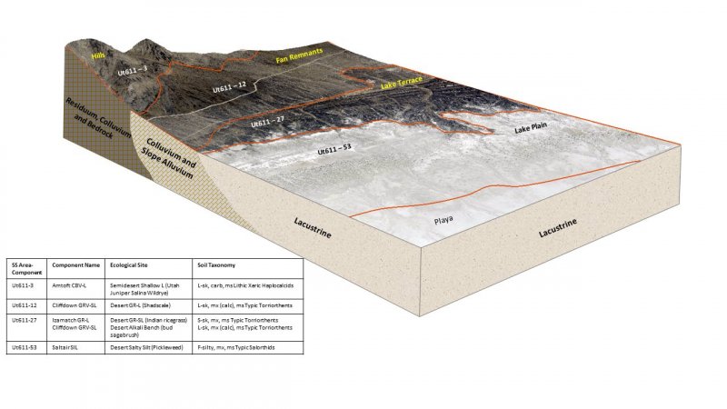
Figure 1.
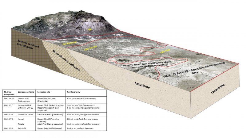
Figure 2.
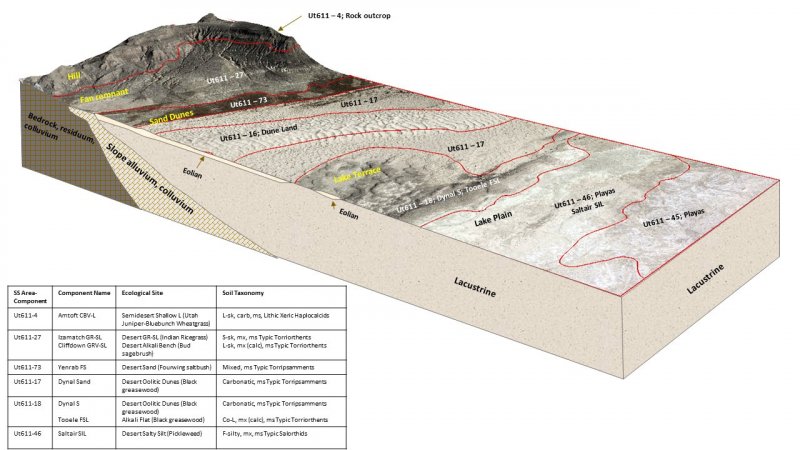
Figure 3.
Table 2. Representative physiographic features
| Landforms |
(1)
Lake plain
(2) Lake terrace (3) Basin floor |
|---|---|
| Flooding duration | Extremely brief (0.1 to 4 hours) to long (7 to 30 days) |
| Flooding frequency | None to occasional |
| Ponding duration | Very brief (4 to 48 hours) to brief (2 to 7 days) |
| Ponding frequency | None to occasional |
| Elevation | 4,200 – 5,100 ft |
| Slope | 1% |
| Ponding depth | 2 – 6 in |
| Water table depth | 8 – 10 in |
| Aspect | Aspect is not a significant factor |
Climatic features
The climate of this site is dry subhumid and semiarid. It is characterized by cold, snowy winters and warm, dry summers. The average annual precipitation ranges from 13 to 19 inches. April and May are typically the wettest months with July and August being the driest. The most reliable sources of moisture for plant growth are the snow that accumulates over the winter, and spring rains, that in combination, wet the sites soil throughout the spring and early summer months. Summer thunderstorms are intermittent and sporadic in nature, and thus are not reliable sources of moisture to support vegetative growth on this site. The mean annual air temperature is 45 to 54 degrees.
Table 3. Representative climatic features
| Frost-free period (average) | 172 days |
|---|---|
| Freeze-free period (average) | 207 days |
| Precipitation total (average) | 16 in |
Figure 4. Monthly precipitation range
Figure 5. Monthly average minimum and maximum temperature
Figure 6. Annual precipitation pattern
Figure 7. Annual average temperature pattern
Influencing water features
This site may occasionally pond for brief periods during the months of March thru June. Ponding depth is typically 2 to 6 inches. A water table is present during much of the year at a depth of 8 to 10 inches.
Soil features
Characteristic soils in this site are very deep and poorly or very poorly drained. The soil moisture and temperature regimes are typic aquic and mesic respectively. The dry surface color is typically a dark grayish brown. These soils formed in lacustrine deposits derived mainly from limestone, shale or quartzite parent material. Soil textures are typically silt loams and silty clay loams. They are strongly saline (100 to 250 mmhos/cm) and moderately to strongly alkaline. Available water capacity is highly variable ranging from 0.0 to 7.1 inches.
This site has been used in the following soil surveys and has been correlated to the following components:
UT601 – Box Elder County, Western Part – Saltair.
UT602 – Box Elder County, Eastern Part – Saltair.
UT607 – Davis-Weber Area – Saltair.
UT612 – Salt Lake Area – Saltair.
Typical Profile (Saltair):
Az – 0-1 inches; silt loam; strongly effervescent; strongly saline; moderately alkaline.
Czgl – 1-4 inches; silty clay loam; strongly effervesent; strongly saline; strongly alkaline.
Czg2 – 4-9 inches; silty clay loam; strongly effervesent; strongly saline; strongly alkaline.
Czg3 – 9-20 inches; silty clay loam; strongly effervesent; strongly saline; strongly alkaline.
Czg4 – 20-32 inches; silt loam; strongly effervesent; strongly saline; strongly alkaline.
2Czg5 – 32-44 inches; silty clay loam; strongly effervesent; strongly saline; strongly alkaline.
2Czg6 – 44-60 inches; silty clay loam; strongly effervesent; strongly saline; strongly alkaline.
Table 4. Representative soil features
| Parent material |
(1)
Lacustrine deposits
–
limestone and shale
|
|---|---|
| Surface texture |
(1) Silt (2) Silty clay loam |
| Family particle size |
(1) Clayey |
| Drainage class | Poorly drained to very poorly drained |
| Permeability class | Slow to very slow |
| Soil depth | 60 in |
| Surface fragment cover <=3" | Not specified |
| Surface fragment cover >3" | Not specified |
| Available water capacity (0-40in) |
7.1 in |
| Calcium carbonate equivalent (0-40in) |
5 – 40% |
| Electrical conductivity (0-40in) |
100 – 250 mmhos/cm |
| Sodium adsorption ratio (0-40in) |
100 – 1,000 |
| Soil reaction (1:1 water) (0-40in) |
7.9 – 9 |
| Subsurface fragment volume <=3" (Depth not specified) |
Not specified |
| Subsurface fragment volume >3" (Depth not specified) |
Not specified |
Ecological dynamics
This site developed under the natural ecological conditions found in the Great Basin portion of the Basin and Range Province, and includes the influence of the Great Salt Lakes natural water level fluxuations, waterfowl foraging, and climate. Vegetation is composed primarily of forbs with Utah pickleweed dominating the aspect. Red pickleweed, seepweed and low goosefoot may also be present. Grasses are less common but desert saltgrass and foxtail barley are sometimes present. On average years, plant growth begins after seasonal ponding recedes and ends when available moisture is gone.
This site is of limited extent and is usually found just above lake playas and just below the Alkali Flat (Greasewood) 028AY004UT site. Plants common on the Alkali Flat site such as black greasewood may increase on this site where it adjoins the Alkali Flat site.
During periods of drought, total site production often decreases, but returns to normal levels during years with average or above average precipitation.
The Great Salt Lake is an inland water body with no outlet and is thus highly affected by weather patterns that cause it the grow or shrink in size. As its shoreline moves up or down, ecological sites found along its shore must also migrate in their relationship to its shore. Man has caused additional changes to the areas ecology by developing a series of canals, dikes and diversions designed to control and manage the lakes incoming water. In spite of these natural and human caused impacts, distinct ecological sites can be found surrounding this body of water.
This ecological site has been grazed by domestic livestock since they were first introduced into the area around 1860. This livestock introduction, including the use of fencing, and the development of reliable water sources, has influenced the disturbance regime historically associated with this ecological site. This site often served as wintering pastures for sheep and cattle producers.
Improperly managed livestock grazing (continuous season long grazing, heavy stocking rates, repeated early spring grazing, etc.) can cause this site to depart from its reference plant community. During periods of continous winter grazing by sheep, alkail seepweed and any perennial grasses present will also decrease leaving Utah and red pickleweed as the principle remaining species.
Waterfowl, including many species of geese and ducks prefer pickleweed as forage and will feed on it during much of the year. The common name given to pickleweed by local ranchers is goose weed because of its use by geese.
As vegetative communities respond to changes in management or natural influences that move them from one state to another, a return to previous states may not be possible. The amount of energy needed to affect these vegetative shifts depends on present biotic and abiotic features and the desired results.
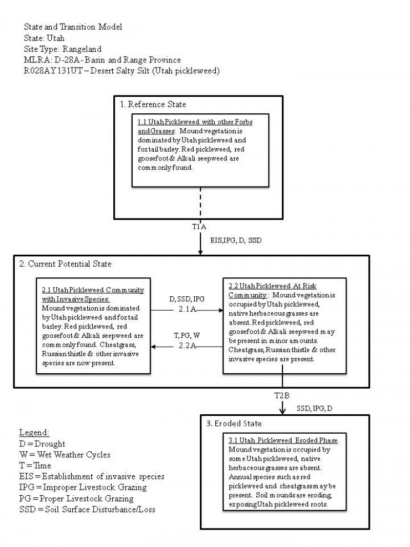
The following state and transition model diagram depicts some of the most commonly occurring plant communities found on this ecological site. These communities may not represent every possibility, but they are the most prevalent and repeatable. As more data are collected, some of these plant communities may be revised or removed, and new ones may be added. This model was developed using range data collected for publication of the Box Elder County, Eastern Part, Soil Survey and the recent Eastern Shores update. Both ocular and measured data was collected and utilized. Range data collected by the NRCS since 1983 was also used.
State and transition model
More interactive model formats are also available.
View Interactive Models
More interactive model formats are also available.
View Interactive Models
Click on state and transition labels to scroll to the respective text
Ecosystem states
State 1 submodel, plant communities
State 2 submodel, plant communities
State 3 submodel, plant communities
State 1
Reference State
This reference state describes the natural biotic communities that may become established on the Desert Salty Silt - Utah pickleweed ecological site when all successional sequences are completed under the natural disturbance regime. The reference state is self-sustaining and resistant to change due to its high resistance to natural disturbances and high resilience following natural disturbances. When natural disturbances occur, the rate of recovery is variable due to disturbance intensity. This community could become at risk where increased disturbance frequencies allow for the introduction of annuals, such as cheatgrass and Russian thistle. Once invasive plants become established, return to the reference state may not be possible. Reference State: Community phases influenced by native herbivore grazing, insect herbivory, and weather. Indicators: A sparse perennial cool and warm season understory with Utah pickleweed and foxtail barley forming the dominant visual aspect. Feedbacks: Extended drought and/or improper grazing that result in a reduction of native perennial plant vigor which may cause invasive species to become established in the community, increased bare ground, erosion, and soil loss. Properly managed grazing that maintains the perennial plant community. At-risk Community Phase: All communities in this state are at risk when native plants are stressed and/or nutrients become available for invasive plants to establish. Trigger: Introduction and establishment of non-native invasive plants such as cheatgrass and Russian thistle.
Community 1.1
Utah pickleweed with other forbs and grasses.

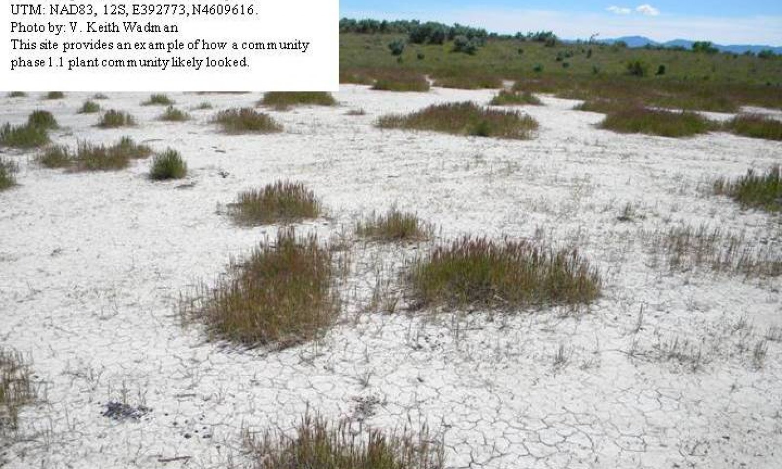
Figure 8. Community Phase 1.1
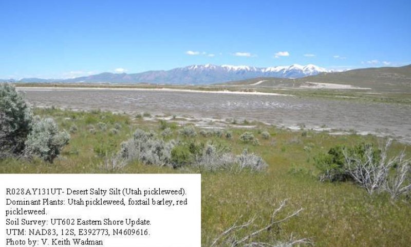
Figure 9. Site Showing Spring Ponding
This community phase is characterized by a perennial forb layer dominated by Utah pickleweed, with other native forbs and perennial grasses commonly present. Common species include red pickleweed, low goosefoot, foxtail barley and desert saltgrass. Where grass cover increases, forb interspaces are filled and vegetative production significantly increases. Other perennial grasses, shrubs, and forbs may also be present and cover is variable. Bare ground is also variable (20-60%). The following tables provide an example of the typical vegetative floristics of a commumity phase 1.1 plant community.
Figure 10. Annual production by plant type (representative values) or group (midpoint values)
Table 5. Annual production by plant type
| Plant type | Low (lb/acre) |
Representative value (lb/acre) |
High (lb/acre) |
|---|---|---|---|
| Forb | 40 | 70 | 100 |
| Grass/Grasslike | 40 | 60 | 90 |
| Shrub/Vine | 10 | 20 | 40 |
| Total | 90 | 150 | 230 |
State 2
Current Potential State
The current potential state is similar to the reference state, except that non-native and/or invasive species are present in all community phases. This state is generally dominated by Utah pickleweed and foxtail barley; however, depending on disturbance history, native grasses, forbs, or other shrubs may be lacking on the site. Primary disturbance mechanisms include climate fluctuations, waterfowl grazing, domestic livestock grazing, and surface disturbances such as road and pipeline development and off road vehicle (OHV) use. Timing of these disturbances dictates the ecological dynamics that can occur. The current potential state is still self- sustaining; but could be losing resistance to change due to increased disturbance and lower resilience following disturbances. Indicators: A site dominated by Utah pickleweed and foxtail barley. Red pickleweed and desert saltgrass are also commonly present. Non-native species are now present in the stand. Feedbacks: Extended drought resulting in a reduction of native perennial plant vigor. Normal fluctuations in weather allowing for the maintenance of both perennial forbs and grasses. At-risk Community Phase: This state is at risk when perennial plant cover is reduced and nutrients become available for invasive plants to flourish. Trigger: Spread of invasive plants to fill available niches.
Community 2.1
Utah pickleweed with invasive species.
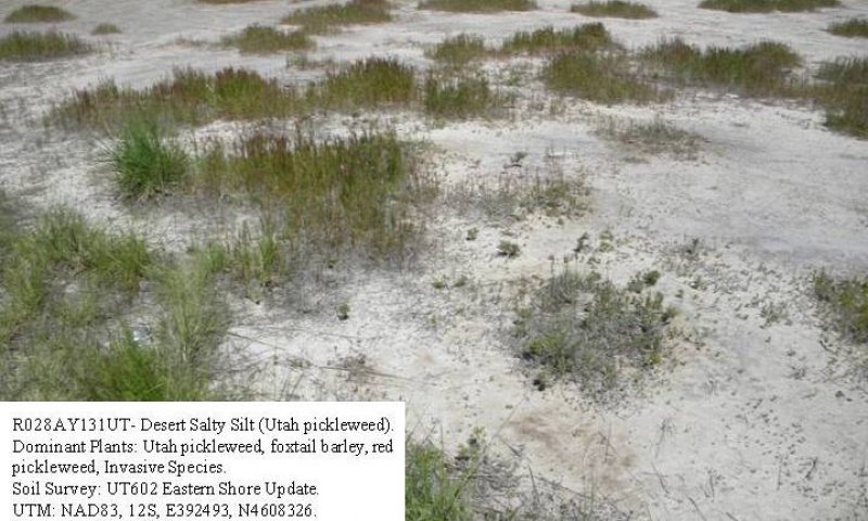
Figure 11. Community Phase 2.1
This community is characterized by a perennial forb layer dominated by Utah pickleweed, with other native forbs and perennial grasses commonly present. Common species include red pickleweed, low goosefoot, foxtail barley and saltgrass. Invasive species including cheatgrass and Russian thistle are now present. Where grass cover increases, forb interspaces are filled and vegetative production significantly increases. Other perennial grasses, shrubs, and forbs may also be present and cover is variable. Bare ground is also variable (20-60%). The following tables provide an example of the typical vegetative floristics of a commumity phase 2.1 plant community.
Figure 12. Annual production by plant type (representative values) or group (midpoint values)
Table 6. Annual production by plant type
| Plant type | Low (lb/acre) |
Representative value (lb/acre) |
High (lb/acre) |
|---|---|---|---|
| Forb | 40 | 70 | 100 |
| Grass/Grasslike | 40 | 60 | 90 |
| Shrub/Vine | 10 | 20 | 40 |
| Total | 90 | 150 | 230 |
Community 2.2
Utah pickleweed At Risk Community.
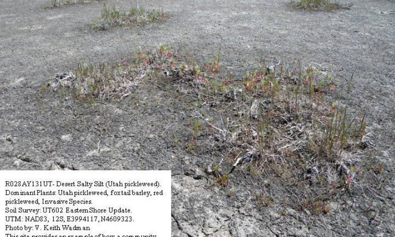
Figure 13. Community Phase 2.2
This community is characterized by a perennial forb layer occupied by Utah pickleweed, with other native forbs and perennial grasses present in limited amounts. Common species include red pickleweed, low goosefoot, foxtail barley and saltgrass. Invasive species including cheatgrass and Russian thistle are now present. Where grass cover decreases, forb interspaces become void of vegetation, production significantly decreases. Other grasses, shrubs, and forbs may be present in very minor amounts and cover is variable. Bare ground is also variable (40-80%). The following tables provide an example of the typical vegetative floristics of a commumity phase 2.1 plant community.
Figure 14. Annual production by plant type (representative values) or group (midpoint values)
Table 7. Annual production by plant type
| Plant type | Low (lb/acre) |
Representative value (lb/acre) |
High (lb/acre) |
|---|---|---|---|
| Forb | 20 | 40 | 70 |
| Grass/Grasslike | 20 | 30 | 50 |
| Shrub/Vine | 0 | 10 | 20 |
| Total | 40 | 80 | 140 |
Pathway 2.1A
Community 2.1 to 2.2


When perennial plants are reduced as a result of soil surface disturbance, improper livestock grazing and/or dry climate, annual invasive grasses and forbs may increase. As the soil becomes exposed, and the perennial plants are removed, there is more opportunity for cheatgrass and other invasive annuals to dominate the site. Soil stability decreases, and interspaces between perennial native plants increase, changing the vegetative dynamics of the site.
Pathway 2.2A
Community 2.2 to 2.1


Over time, without additional disturbance and in the presents of proper livestock management and average or above average weather periods, Utah pickleweed and perennial grasses may increase.
State 3
Eroded State
This community phase is characterized by sparse stand of Utah pickleweed associated with a few annuals such as red pickleweed, cheatgrass and Russian thistle. Total site vegetation is significently reduced. Cryptogamic crust, where present, and the roots of Utah pickleweed may be all that are holding the soil in place. When these conditions persist, the sites soil mounds begins to erode away turning the area into a lake playa. Indicators: A site occupied by a sparse stand of Utah pickleweed. Red pickleweed may also be present. Non-native species may or may not be present in the stand. Feedbacks: Extended drought resulting in a reduction of native perennial plant vigor. Normal fluctuations in weather allowing for the maintenance of both perennial forbs and grasses. At-risk Community Phase: This state is at risk when perennial plant cover is reduced and soil begins to erode and move into surrounding lake playas. Trigger: Loss of soil sufficient to destroy the sites integrity.
Community 3.1
Utah pickleweed eroded phase.
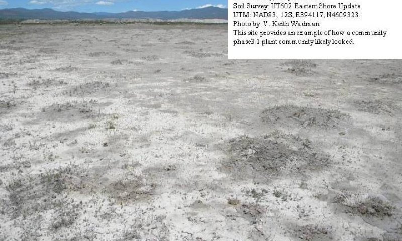
Figure 15. Community Phase 3.1
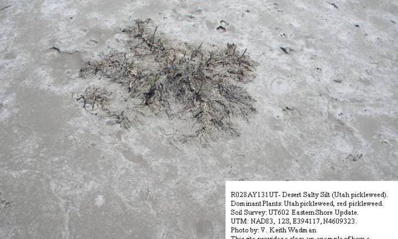
Figure 16. Community Phase 3.1 Close-up.
This community is characterized by a remnant forb layer occupied by Utah pickleweed, with other native forbs and perennial grasses present in very limited amounts. When present, species may include red pickleweed, low goosefoot, foxtail barley and saltgrass. Invasive species including cheatgrass and Russian thistle may also be present when conditions allow. Forb interspaces are nearly void of vegetation, production significantly decreases. Other grasses, shrubs, and forbs may be present in very minor amounts and cover is variable. Bare ground is also variable (60-90%). The following tables provide an example of the typical vegetative floristics of a commumity phase 3.1 plant community.
Figure 17. Annual production by plant type (representative values) or group (midpoint values)
Table 8. Annual production by plant type
| Plant type | Low (lb/acre) |
Representative value (lb/acre) |
High (lb/acre) |
|---|---|---|---|
| Forb | 10 | 30 | 50 |
| Grass/Grasslike | 0 | 10 | 20 |
| Shrub/Vine | 0 | 5 | 10 |
| Total | 10 | 45 | 80 |
Transition T1A
State 1 to 2
This transition is from the native perennial forb and grass community in the reference state to a state that now contains invasive species. Events that allow for the establishment of invasive plant species include, improper livestock grazing that reduces perennial vegetation, prolonged drought, surface disturbances, etc. However, invasive species such as cheatgrass have been known to invade intact perennial plant communities with little to no disturbance. Once invasive species are found in the plant community a threshold has been crossed.
Transition T2A
State 2 to 3
This transition is from the Current Potential State Community 2.2 - Utah picklwweed/At Risk Phase to State 3 - eroded state which has a very sparse stand of Utah pickleweed, red pickleweed and annual invasive plants. This transition occurs as events favor the reduction of perennial species and the increase of annual invasive plants. Typically, this occurs as total site production continues to decline due to surface disturbance, improper livestock grazing and/or drought. Once vegetative cover is reduced to the point where plants can hold the sites soil in place, a threshold has been crossed.
Additional community tables
Table 9. Community 1.1 plant community composition
| Group | Common name | Symbol | Scientific name | Annual production (lb/acre) | Foliar cover (%) | |
|---|---|---|---|---|---|---|
|
Grass/Grasslike
|
||||||
| 1 | 60–90 | |||||
| foxtail barley | HOJU | Hordeum jubatum | 25–45 | – | ||
| saltgrass | DISP | Distichlis spicata | 10–20 | – | ||
| meadow barley | HOBRB2 | Hordeum brachyantherum ssp. brachyantherum | 10–20 | – | ||
| 2 | Sub-dominant | 20–40 | ||||
| scratchgrass | MUAS | Muhlenbergia asperifolia | 10–20 | – | ||
| annual rabbitsfoot grass | POMO5 | Polypogon monspeliensis | 10–20 | – | ||
| weeping alkaligrass | PUDI | Puccinellia distans | 10–20 | – | ||
| Nuttall's alkaligrass | PUNU2 | Puccinellia nuttalliana | 10–20 | – | ||
|
Forb
|
||||||
| 3 | Forbs | 40–100 | ||||
| Utah swampfire | SAUT2 | Sarcocornia utahensis | 40–80 | – | ||
| red swampfire | SARU | Salicornia rubra | 20–30 | – | ||
| Pursh seepweed | SUCA2 | Suaeda calceoliformis | 10–20 | – | ||
| Mojave seablite | SUMO | Suaeda moquinii | 10–20 | – | ||
| low goosefoot | CHCH | Chenopodium chenopodioides | 5–10 | – | ||
| ribseed sandmat | CHGL13 | Chamaesyce glyptosperma | 5–10 | – | ||
| povertyweed | IVAX | Iva axillaris | 5–10 | – | ||
|
Shrub/Vine
|
||||||
| 4 | Dominant Shrubs | 20–40 | ||||
| greasewood | SAVE4 | Sarcobatus vermiculatus | 15–30 | – | ||
| iodinebush | ALOC2 | Allenrolfea occidentalis | 10–20 | – | ||
| winterfat | KRLA2 | Krascheninnikovia lanata | 10–20 | – | ||
Table 10. Community 2.1 plant community composition
| Group | Common name | Symbol | Scientific name | Annual production (lb/acre) | Foliar cover (%) | |
|---|---|---|---|---|---|---|
|
Grass/Grasslike
|
||||||
| 1 | Dominant Grasses | 60–90 | ||||
| cheatgrass | BRTE | Bromus tectorum | 30–60 | – | ||
| foxtail barley | HOJU | Hordeum jubatum | 25–45 | – | ||
| saltgrass | DISP | Distichlis spicata | 10–20 | – | ||
| meadow barley | HOBRB2 | Hordeum brachyantherum ssp. brachyantherum | 10–20 | – | ||
| 2 | Sub-dominant | 20–40 | ||||
| scratchgrass | MUAS | Muhlenbergia asperifolia | 10–20 | – | ||
| annual rabbitsfoot grass | POMO5 | Polypogon monspeliensis | 10–20 | – | ||
| weeping alkaligrass | PUDI | Puccinellia distans | 10–20 | – | ||
| Nuttall's alkaligrass | PUNU2 | Puccinellia nuttalliana | 10–20 | – | ||
|
Forb
|
||||||
| 3 | Forbs | 40–100 | ||||
| Utah swampfire | SAUT2 | Sarcocornia utahensis | 40–80 | – | ||
| Russian thistle | SAKA | Salsola kali | 20–50 | – | ||
| saltlover | HAGL | Halogeton glomeratus | 20–40 | – | ||
| red swampfire | SARU | Salicornia rubra | 20–30 | – | ||
| Pursh seepweed | SUCA2 | Suaeda calceoliformis | 10–20 | – | ||
| Mojave seablite | SUMO | Suaeda moquinii | 10–20 | – | ||
| povertyweed | IVAX | Iva axillaris | 5–10 | – | ||
| low goosefoot | CHCH | Chenopodium chenopodioides | 5–10 | – | ||
| ribseed sandmat | CHGL13 | Chamaesyce glyptosperma | 5–10 | – | ||
|
Shrub/Vine
|
||||||
| 4 | Dominant Shrubs | 20–40 | ||||
| greasewood | SAVE4 | Sarcobatus vermiculatus | 15–30 | – | ||
| iodinebush | ALOC2 | Allenrolfea occidentalis | 10–20 | – | ||
| winterfat | KRLA2 | Krascheninnikovia lanata | 10–20 | – | ||
Table 11. Community 2.2 plant community composition
| Group | Common name | Symbol | Scientific name | Annual production (lb/acre) | Foliar cover (%) | |
|---|---|---|---|---|---|---|
|
Grass/Grasslike
|
||||||
| 1 | Dominant Grasses | 20–50 | ||||
| cheatgrass | BRTE | Bromus tectorum | 15–30 | – | ||
| foxtail barley | HOJU | Hordeum jubatum | 10–20 | – | ||
| saltgrass | DISP | Distichlis spicata | 5–10 | – | ||
| meadow barley | HOBRB2 | Hordeum brachyantherum ssp. brachyantherum | 5–10 | – | ||
| 2 | Sub-dominant | 10–20 | ||||
| scratchgrass | MUAS | Muhlenbergia asperifolia | 5–10 | – | ||
| annual rabbitsfoot grass | POMO5 | Polypogon monspeliensis | 5–10 | – | ||
| weeping alkaligrass | PUDI | Puccinellia distans | 5–10 | – | ||
| Nuttall's alkaligrass | PUNU2 | Puccinellia nuttalliana | 5–10 | – | ||
|
Forb
|
||||||
| 3 | Forbs | 20–70 | ||||
| Russian thistle | SAKA | Salsola kali | 20–50 | – | ||
| Utah swampfire | SAUT2 | Sarcocornia utahensis | 20–50 | – | ||
| saltlover | HAGL | Halogeton glomeratus | 20–40 | – | ||
| red swampfire | SARU | Salicornia rubra | 20–30 | – | ||
| Pursh seepweed | SUCA2 | Suaeda calceoliformis | 10–20 | – | ||
| Mojave seablite | SUMO | Suaeda moquinii | 10–20 | – | ||
| povertyweed | IVAX | Iva axillaris | 5–10 | – | ||
| low goosefoot | CHCH | Chenopodium chenopodioides | 5–10 | – | ||
| ribseed sandmat | CHGL13 | Chamaesyce glyptosperma | 5–10 | – | ||
|
Shrub/Vine
|
||||||
| 4 | Dominant Shrubs | 0–20 | ||||
| iodinebush | ALOC2 | Allenrolfea occidentalis | 0–10 | – | ||
| winterfat | KRLA2 | Krascheninnikovia lanata | 0–10 | – | ||
| greasewood | SAVE4 | Sarcobatus vermiculatus | 0–10 | – | ||
Table 12. Community 3.1 plant community composition
| Group | Common name | Symbol | Scientific name | Annual production (lb/acre) | Foliar cover (%) | |
|---|---|---|---|---|---|---|
|
Grass/Grasslike
|
||||||
| 1 | Dominant Grasses | 0–20 | ||||
| cheatgrass | BRTE | Bromus tectorum | 10–20 | – | ||
| foxtail barley | HOJU | Hordeum jubatum | 0–15 | – | ||
| saltgrass | DISP | Distichlis spicata | 0–10 | – | ||
| meadow barley | HOBRB2 | Hordeum brachyantherum ssp. brachyantherum | 0–10 | – | ||
| 2 | Sub-dominant | 0–20 | ||||
| scratchgrass | MUAS | Muhlenbergia asperifolia | 0–10 | – | ||
| annual rabbitsfoot grass | POMO5 | Polypogon monspeliensis | 0–10 | – | ||
| weeping alkaligrass | PUDI | Puccinellia distans | 0–10 | – | ||
| Nuttall's alkaligrass | PUNU2 | Puccinellia nuttalliana | 0–10 | – | ||
|
Forb
|
||||||
| 3 | Forbs | 10–50 | ||||
| Utah swampfire | SAUT2 | Sarcocornia utahensis | 10–20 | – | ||
| red swampfire | SARU | Salicornia rubra | 5–10 | – | ||
| Pursh seepweed | SUCA2 | Suaeda calceoliformis | 0–5 | – | ||
| Mojave seablite | SUMO | Suaeda moquinii | 0–5 | – | ||
| low goosefoot | CHCH | Chenopodium chenopodioides | 0–5 | – | ||
| ribseed sandmat | CHGL13 | Chamaesyce glyptosperma | 0–5 | – | ||
| saltlover | HAGL | Halogeton glomeratus | 0–5 | – | ||
| povertyweed | IVAX | Iva axillaris | 0–5 | – | ||
| Russian thistle | SAKA | Salsola kali | 0–5 | – | ||
|
Shrub/Vine
|
||||||
| 4 | Dominant Shrubs | 0–10 | ||||
| iodinebush | ALOC2 | Allenrolfea occidentalis | 0–5 | – | ||
| winterfat | KRLA2 | Krascheninnikovia lanata | 0–5 | – | ||
| greasewood | SAVE4 | Sarcobatus vermiculatus | 0–5 | – | ||
Interpretations
Animal community
--Threatened and Endangered Species--
This section will be populated as more information becomes available.
--Wildlife Interpretation--
This ecological site and associated other wetlands associated with the Great Salt Lake provide critical habitat for migrating birds from both the Pacific and Central Flyway of North America. This area contains abundant food for birds. Birds come to the Refuge by the millions to eat and rest during migration.
The following statistics were provided by the Bear River Migratory Bird Refuge where much of this ecological site is located:
1. Breeding colonies of white-faced ibis contain as many as 18,000 birds.
2. Up to 10,000 American avocets breed at the Refuge annually.
3. One of North America’s three largest American white pelican breeding colonies, containing in excess of 50,000 birds, is found on Gunnison Island in Great Salt Lake.
4. Northern Utah marshes host up to 60 percent of the continental breeding population of cinnamon teal.
5. The Great Salt Lake boasts the largest fall staging concentration of Wilson’s phalaropes in the world, at approximately 500,000 birds. Red-necked phalaropes number nearly 100,000.
6. The Great Salt Lake area hosts greater than 50 percent of the continental breeding population of snowy plovers.
7. The Great Salt Lake area hosts 26 percent of the global population of marbled godwits during migration.
8. Bear River Refuge may attract over 65,000 black-necked stilts in the fall, more than anywhere else in the country.
--Grazing Interpretations--
This site has somewhat limited potential for livestock grazing. It is primarily perennial forbs, with the majority of canopy cover being attributed to Utah pickleweed. Pickleweed can serve as forage for livestock, especially as winter range. When present, grasses, primarily Foxtail barley and saltgrass, can provide good forage for horses, cattle, and sheep; however, many times these species are not abundant enough to support livestock. Grazing must be carefully planned and managed to prevent damage to the site. Before making specific grazing management recommendations, an onsite evaluation should be conducted as part of a science based grazing management plan.
Hydrological functions
The soils associated with this ecological site are generally in Hydrologic Soil Group D due to their high runoff potential when dry and a water table during much of the year at 8 to 10 inches (NRCS National Engineering Handbook). Hydrologic groups are used in equations that estimate runoff from rainfall. These estimates are needed for solving hydrologic problems that arise in planning watershed-protection and flood-prevention projects and for designing structures for the use, control and disposal of water. Surface disturbance can alter the hydrology by decreasing plant cover and increasing bare ground. Fire can also affect hydrology, but it is rare on this site. Fire intensity, fuel type, soil, climate, and topography can each have different influences. (National Range and Pasture Handbook, 2003)
Recreational uses
This ecological site provides forage for several species of both residential and migratory waterfowl as they pass through the area. These waterfowl reside and nest in marshes and open water but often travel to this site to forage. This movement back and forth creates opportunities for recreational hunting during open seasons.
Wood products
None.
Other information
--Poisonous and Toxic Plant Communities--
Russian thistle can be an invasive toxic plant on this site, causing nitrate and to a lesser extent oxalate poisoning, which affects all classes of livestock. Livestock rarely consume this plant species unless other forage is not available. The buildup of nitrates in these plants is highly dependent upon environmental factors, such as after a rain storm during a drought, during periods with cool/cloudy days, and on soils high in nitrogen and low in sulfur and phosphorus. Nitrate collects in the plant stems and can persist throughout the growing season. Clinical signs of nitrate poisoning include drowsiness, weakness, muscular tremors, increased heart and respiratory rates, staggering gait, and death. Conversely, oxalate poisoning causes kidney failure; clinical signs include muscle tremors, tetany, weakness, and depression. Poisoning generally occurs when livestock consume and are not accustomed to grazing oxalate containing plants. Animals with prior exposure to oxalates have increased numbers of oxalate degrading rumen microflora and thus are able to degrade the toxin before clinical poisoning can occur (Knight and Walter, 2001).
--Invasive Plant Communities--
As ecological conditions deteriorate and native vegetation decreases due to disturbance (improper livestock grazing, drought, off road vehicle overuse, erosion, etc.) invasive species can establish on the site. Of particular concern in arid environments are the non-native annual invaders including cheatgrass, Russian thistle, kochia, halogeton, common sunflower and mustards. The presence of these species will depend on soil properties and moisture availability; however, these invaders are highly adaptive and can flourish in many locations. Once established, complete removal is difficult but suppression may be possible.
--Fire Ecology--
The ability for any ecological site to carry fire depends primarily on its present fuel load and plant moisture content. Sites with small fuel loads will burn more slowly and less intensely than sites with large fuel loads.
This ecological site, like many found in semi-desert communities in the Basin and Range Province may have evolved without a significant influence of fire. Because this ecological site is comprised of scattered low stature Utah pickleweed and similar associated species which are located on mounds surrounded by bare interspaces, it is unlikely to carry a fire even when high winds, high temperatures, and low humidity are present.
Supporting information
Inventory data references
This site description was developed from an old pickleweed site concept that was dropped from the list of NRCS ecological site descriptions several years ago.
It was developed using new data and photos collected during the East Shore Soil Survey udate and includes a state and transition model. A significant portion of this ecological site was inventoried during the survey. This site description will need to be updated as more data are collected.
Type locality
| Location 1: Box Elder County, UT | |
|---|---|
| UTM zone | N |
| UTM northing | 4609616 |
| UTM easting | 392773 |
| General legal description | East of Little Mountain; along public access road leading to DWR public hunting preserve. |
Other references
US Fish and Wildlife Service; Bear River Migratory Bird Refuge; BearRiver@fws.gov
Knight, A.P. and R.G. Walter. 2001. A guide to plant poisoning of animals in North America. Teton NewMedia. Jackson, WY.
National Engineering Handbook. US Department of Agriculture, Natural Resources Conservation Service. Available: http://www.info.usda.gov/CED/Default.cfm#National%20Engineering%20Handbook. Accessed February 25, 2008.
NRCS Grazing Lands Technology Institute. 2003. National Range and Pasture Handbook. Fort Worth, TX, USA: US Department of Agriculture, Natural Resources Conservation Service, 190-VI-NRPH.
NPS.gov. 2008. Canyonlands National Park. Nature and Science. Available: http://www.nps.gov/cany/naturescience/. Accessed on January 4, 2008.
Utah Climate Summaries. 2009. Available: http://www.wrcc.dri.edu/summary/climsmut.html. Accessed on February 25, 2008.
Plant.USDA.gov, Natural Resources Conservation Service, Plants Database, accessed at various times.
United States Department of Agriculture Handbook 296, Land resource Regions and Major Land Resource Areas of the United States, the Caribbean, and the Pacific Basin, Issued 2006.
Contributors
G. Brock Benson
V. Keith Wadman, Brock Benson
Approval
Jamin Johanson, 5/02/2025
Rangeland health reference sheet
Interpreting Indicators of Rangeland Health is a qualitative assessment protocol used to determine ecosystem condition based on benchmark characteristics described in the Reference Sheet. A suite of 17 (or more) indicators are typically considered in an assessment. The ecological site(s) representative of an assessment location must be known prior to applying the protocol and must be verified based on soils and climate. Current plant community cannot be used to identify the ecological site.
| Author(s)/participant(s) | V. Keith Wadman (NRCS, Ret.) |
|---|---|
| Contact for lead author | shane.green@ut.usda.gov |
| Date | 06/10/2011 |
| Approved by | Jamin Johanson |
| Approval date | |
| Composition (Indicators 10 and 12) based on | Annual Production |
Indicators
-
Number and extent of rills:
Very minor rill development should be apparent in reference community under normal conditions. A slight increase may be observed following significant storm or snow melt events. Any rills should be short (< 1’) and spaced 2’ – 4’. The very few rills will run from the soil mounds comprising this site onto the interspaced playas and will travel in random directions. Evidence of rills will slowly decrease in the months following major weather events. Rills development may also be slightly more pronounced on the edges of this site where run-off onto the playa occurs. -
Presence of water flow patterns:
Flow patterns are confined to the playa interspaces within this site, which will also often have standing water after storm events. Playa flow patterns are normally <25 feet long, flow around pickleweed mounds, and are typically spaced 12 to 15 feet apart. -
Number and height of erosional pedestals or terracettes:
Very slight evidence of pedestals or terracettes caused by accelerated water erosion may be evident in the reference community. 1 – 2 inches of depositional mounding within Pickleweed clumps is normal and may not be water erosion caused. -
Bare ground from Ecological Site Description or other studies (rock, litter, lichen, moss, plant canopy are not bare ground):
Bare ground ranges from 50% - 60% in the reference community. -
Number of gullies and erosion associated with gullies:
Developed gully channels are a normal component of this site. Gullies associated with reference areas will typically have stable, partially vegetated sides and bottoms with no evidence of head-cutting. Some evidence of disturbance may be apparent following significant weather events or when gullies convey runoff from higher elevation rocky or naturally eroding areas -
Extent of wind scoured, blowouts and/or depositional areas:
No evidence of wind generated soil movement is present in reference communities. Wind caused blowouts are also not present. Slight depositional mounding within Saltgrass patches and under pickleweed canopies is a normal characteristic of this site. -
Amount of litter movement (describe size and distance expected to travel):
Most litter resides in place within grass patches or under plant canopies. Some movement of the finest material (< 1/8” or less) may move (1’ – 2’) in the direction of prevailing winds or down slope if being transported by water. Little accumulation is observed behind obstructions. -
Soil surface (top few mm) resistance to erosion (stability values are averages - most sites will show a range of values):
This site should have a soil stability rating of 3 to 4 under plant canopies and 2 to 3 in interspaces. Surface textures are typically silts containing no coarse fragments. -
Soil surface structure and SOM content (include type of structure and A-horizon color and thickness):
Soil surface is 1 inch deep and structure is weak, thick platy. The A-horizon color is very light colored. Where surface soil is lost, increased clay and silt percentages are common in the remaining soil material. -
Effect of community phase composition (relative proportion of different functional groups) and spatial distribution on infiltration and runoff:
The presence of healthy Utah Pickleweed/ foxtail barley patches in the reference community provides for the best infiltration and least runoff from storm events and snow melt. As perennial vegetation decreases and bare ground increases, runoff increases and soil loss is accelerated. -
Presence and thickness of compaction layer (usually none; describe soil profile features which may be mistaken for compaction on this site):
None. Soils are deep to very deep. Increases in clay or silt content in subsoil layers could be mistaken for compaction. -
Functional/Structural Groups (list in order of descending dominance by above-ground annual-production or live foliar cover using symbols: >>, >, = to indicate much greater than, greater than, and equal to):
Dominant:
Utah pickleweed > Foxtail barley.Sub-dominant:
Red pickleweed > saltgrass > meadow barley.Other:
Dominance by average annual production: Non-sprouting perennial forbs > Cool season perennial grasses > other perennial and annual native forbs. Biological soil crust is variable in its expression where present on this site and is measured as a component of ground cover.Additional:
Perennial and annual forbs can be expected to vary widely in their expression in the plant community based upon departures from average growing conditions. Functional/structural groups may appropriately contain non-native species if their ecological function is the same as the native species in the reference state. -
Amount of plant mortality and decadence (include which functional groups are expected to show mortality or decadence):
All age classes of perennial grasses and forbs should be present on an average to above average precipitation year with age class expression likely subdued during below average years, or on sites with high (usually greater than 65%) similarity index (late seral to historic climax). In general, a mix of age classes may be expected with some dead and decadent plants present. -
Average percent litter cover (%) and depth ( in):
Litter amount will vary based on pickleweed mound size and long-term weather patterns. -
Expected annual annual-production (this is TOTAL above-ground annual-production, not just forage annual-production):
150-250 #/acre on an average year. -
Potential invasive (including noxious) species (native and non-native). List species which BOTH characterize degraded states and have the potential to become a dominant or co-dominant species on the ecological site if their future establishment and growth is not actively controlled by management interventions. Species that become dominant for only one to several years (e.g., short-term response to drought or wildfire) are not invasive plants. Note that unlike other indicators, we are describing what is NOT expected in the reference state for the ecological site:
Cheatgrass, Russian thistle, halogeton, kochia. -
Perennial plant reproductive capability:
All perennial plants should have the ability to reproduce sexually or asexually in most years, except in drought years.
Print Options
Sections
Font
Other
The Ecosystem Dynamics Interpretive Tool is an information system framework developed by the USDA-ARS Jornada Experimental Range, USDA Natural Resources Conservation Service, and New Mexico State University.
Click on box and path labels to scroll to the respective text.