Natural Resources
Conservation Service
Ecological site R029XY015NV
SHALLOW CALCAREOUS HILL 8-10 P.Z.
Last updated: 2/20/2025
Accessed: 04/10/2026
General information
Provisional. A provisional ecological site description has undergone quality control and quality assurance review. It contains a working state and transition model and enough information to identify the ecological site.
MLRA notes
Major Land Resource Area (MLRA): 029X–Southern Nevada Basin and Range
The Southern Nevada Basin and Range MLRA (29) represents the transition from the Mojave Desert to the Great Basin. It is cooler and wetter than the Mojave. It is warmer and typically receives more summer precipitation than the Great Basin. This area is in Nevada (73 percent), California (25 percent), and Utah (2 percent). It makes up about 26,295 square miles (68,140 square kilometers). Numerous national forests occur in the area, including the San Bernardino, Angeles, Sequoia, Inyo, Humboldt-Toiyabe, and Dixie National Forests. Portions of Death Valley National Monument, the Nuclear Regulatory Commission’s Nevada Test Site, the Hawthorne Ammunition Depot, and the Nellis Air Force Range in Nevada and the China Lake Naval Weapons Center in California also are in this MLRA. The northeast part of the Paiute Indian Reservation and the southern third of the Walker River Indian Reservation are in the part of this MLRA in Nevada, and the Lone Pine, Fort Independence, and Big Pine Indian Reservations are in the part in California.
Physiography:
The entire area is in the Great Basin Section of the Basin and Range Province of the Intermontane Plateaus. The area of broad, nearly level, aggraded desert basins and valleys between a series of mountain ranges trending north to south. The basins are bordered by sloping fans and pluvial lake terraces. The mountains are uplifted fault blocks with steep side slopes and not well dissected due to limited annual precipitation. Most of the valleys in this MLRA are closed basins or bolsons containing sinks or playa lakes.
Geology:
The mountains are dominated by Pliocene and Miocene andesite and basalt rocks, Paleozoic and Precambrian carbonate rocks prominent in some areas. Scattered outcrops of older Tertiary intrusives and very young tuffaceous sediments (Pliocene and Miocene) are in the western and eastern thirds of this MLRA. The valleys consist mostly of alluvial fill and playa deposits at the lowest elevations in the closed basins.
Climate:
The average annual precipitation is 3 to 12 inches (75 to 305 millimeters) in most of this area. It may be as high as 29 inches (735 millimeters), on the higher mountain slopes. Most of the rainfall occurs as high-intensity, convective thunderstorms during the growing season. Summers are dry, but sporadic storms are common in July and August.
Water Resources:
Water resources are scarce. Ground water and surface water sources are limited. Streams are small and intermittent. Quality of surface water in naturally degraded as streams cross area of valley fill effected by dissolved salts. Irrigation water may raise the levels of dissolved salts and suspended sediments causing contamination.
Soils:
Dominant soil orders include Entisols and Aridisols.
Ecological site concept
The Shallow Calcareous Hill 8-10 P.Z. site occurs on summits and backslopes of mountains and low hills. Slopes range from 2 to over 50 percent, but slope gradients of 8 to 50 percent are typical. Elevations are 4600 to about 7000 feet. The soils are very shallow and have been derived from volcanic sources. These soils are calcareous with slight to violent effervescence in all parts.
Associated sites
| R029XY010NV |
LOAMY SLOPE 8-10 P.Z. This site occurs on piedmont slopes, rock pediments, hills, and lower mountain sideslopes on all exposures. Slopes range from 4 to 75 percent, but slope gradients of 15 to 50 percent are typical. Elevations are 4400 to about 8200 feet. The soils are very shallow to moderately deep and are derived from a variety of parent materials. The surface may be stony, cobbly or gravelly. |
|---|---|
| R029XY014NV |
SHALLOW CALCAREOUS SLOPE 8-12 P.Z. This site occurs on summits and backslopes of hills and mountains, fan remnants, and rock pediments. Slopes range from 2 to over 75 percent, but slope gradients of 15 to 50 percent are typical. Elevations are 4300 to about 8800 feet. The soils on this site are calcareous or carbonatic and have a shallow effective rooting zone with depth to a hardpan or bedrock ranging from 5 to 20 inches. The soils have high amounts of gravels throughout the soil profile and are well drained to moderately well drained. The soil surface typically has a cover of 75 percent or more rock fragments. |
| F029XY071NV |
Shallow Rocky Loam 10-12" P.Z is found on shallow soils on mountains and hills at greater than 15 percent slopes. The dominant vegetation is typically Utah juniper (Juniperus osteosperma), black sagebrush (Artemisia nova), and Indian ricegrass (Achnatherum hymenoides). The Shallow Rocky Loam 10-12" P.Z. was previously known as JUOS WSG 0D0404 10 to 12. |
| R029XY008NV |
SHALLOW CALCAREOUS LOAM 8-12 P.Z. This site occurs on fan remnants, inset fans, and mountains on all exposures. Slopes range from 0 to 75 percent, but slope gradients of 4 to 30 percent are most typical. Elevations are 4200 to 8000 feet. The soils associated with this site are very shallow to very deep or they have a restrictive layer within the main rooting depth. These soils are moderately to strongly calcareous and soil reaction increases with soil depth. Some soils will accumulate variable concentrations of salts and sodium in their lower substratum. |
| R029XY081NV |
SHALLOW CALCAREOUS HILL 10-14 P.Z. This site occurs on summits and sideslopes of hills, mountains, fan remnants, and rock pediments on all aspects. Slopes range from 4 to 75 percent, but slope gradients of 15 to 50 are typical. Elevations are 4400 to about 8800 feet. The soils are very shallow to shallow to bedrock or duripan and well drained. |
Similar sites
| R029XY028NV |
SHALLOW CALCAREOUS SLOPE 12-14 P.Z. PSSPI dominant grass |
|---|---|
| R029XY081NV |
SHALLOW CALCAREOUS HILL 10-14 P.Z. More productive site; PUST and JUOS major species |
| R029XY099NV |
STONY CALCAREOUS HILL BEFR important shrub |
| R029XY014NV |
SHALLOW CALCAREOUS SLOPE 8-12 P.Z. PUST and JUOS minor species, if present |
| R029XY045NV |
STONY CALCAREOUS SLOPE 8-12 P.Z. More productive site |
| R029XY008NV |
SHALLOW CALCAREOUS LOAM 8-12 P.Z. More productive site |
Table 1. Dominant plant species
| Tree |
Not specified |
|---|---|
| Shrub |
(1) Purshia stansburiana |
| Herbaceous |
(1) Achnatherum hymenoides |
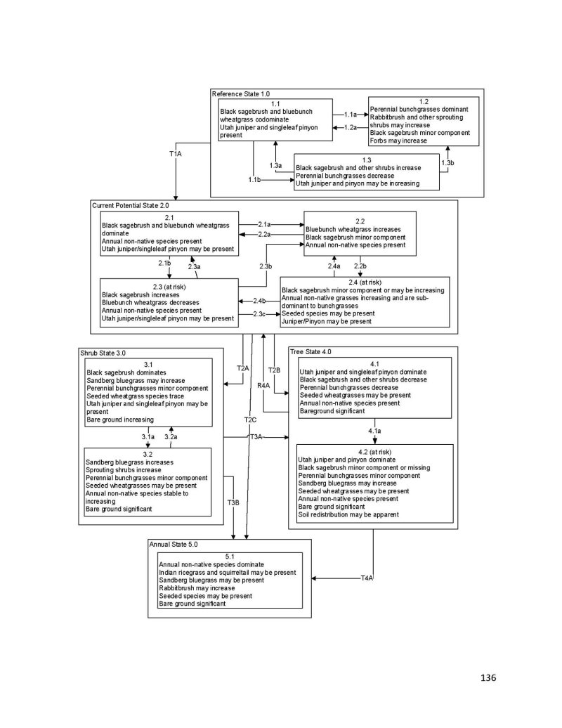
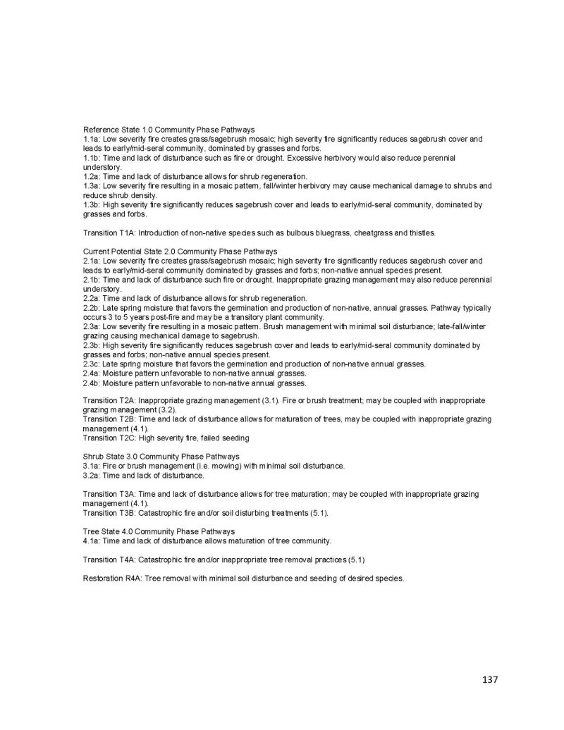
Click on box and path labels to scroll to the respective text.