Natural Resources
Conservation Service
Ecological site R029XY045NV
STONY CALCAREOUS SLOPE 8-12 P.Z.
Accessed: 02/09/2026
General information
Provisional. A provisional ecological site description has undergone quality control and quality assurance review. It contains a working state and transition model and enough information to identify the ecological site.

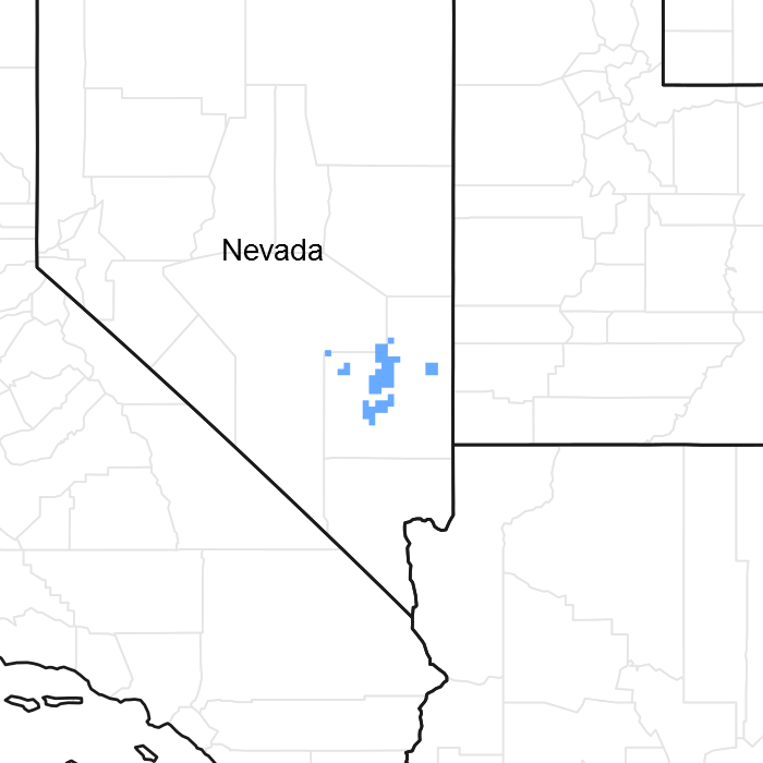
Figure 1. Mapped extent
Areas shown in blue indicate the maximum mapped extent of this ecological site. Other ecological sites likely occur within the highlighted areas. It is also possible for this ecological site to occur outside of highlighted areas if detailed soil survey has not been completed or recently updated.
Associated sites
| F029XY069NV |
PIMO-JUOS WSG 0R0504 12 to 16 |
|---|---|
| R029XY064NV |
STONY SLOPE 5-8 P.Z. |
| R029XY073NV |
BOULDERY SLOPE 8-12 P.Z. |
Similar sites
| R029XY014NV |
SHALLOW CALCAREOUS SLOPE 8-12 P.Z. ACSP12 minor grass |
|---|---|
| R029XY099NV |
STONY CALCAREOUS HILL BEFR important shrub |
| R029XY028NV |
SHALLOW CALCAREOUS SLOPE 12-14 P.Z. PSSPI dominant grass |
| R029XY081NV |
SHALLOW CALCAREOUS HILL 10-14 P.Z. Less productive site |
| R029XY008NV |
SHALLOW CALCAREOUS LOAM 8-12 P.Z. ACSP12 minor grass |
| R029XY015NV |
SHALLOW CALCAREOUS HILL 8-10 P.Z. JUOS dominates visual aspect |
Table 1. Dominant plant species
| Tree |
Not specified |
|---|---|
| Shrub |
(1) Artemisia nova |
| Herbaceous |
(1) Achnatherum speciosum |
Physiographic features
This site occurs on sideslopes and summits of low mountains and hills on all exposures. Slopes range from 8 to 75 percent, but slope gradients of 15 to 50 percent are typical. Elevations are 4700 to about 5500 feet.
Table 2. Representative physiographic features
| Landforms |
(1)
Mountain
(2) Hill |
|---|---|
| Flooding frequency | None |
| Ponding frequency | None |
| Elevation | 4,700 – 5,500 ft |
| Slope | 8 – 75% |
| Aspect | Aspect is not a significant factor |
Climatic features
The climate associated with this site is arid, characterized by cool, moist winters and hot, dry summers. Average annual precipitation is 8 to 12 inches. Mean annual air temperature is 50 to 56 degrees F. The average growing season is about 120 to 150 days
Table 3. Representative climatic features
| Frost-free period (average) | 150 days |
|---|---|
| Freeze-free period (average) | 0 days |
| Precipitation total (average) | 12 in |
Figure 2. Monthly average minimum and maximum temperature
Influencing water features
There are no influencing water features associated with this site.
Soil features
The soils associated with this site are shallow. They have formed predominantly from volcanic rock sources and have a shallow effective rooting zone with depth to a hardpan or bedrock ranging from 10 to 20 inches. The soils have high amounts of gravels throughout the soil profile. The soil surface typically has a cover of 75 percent or more rock fragments. The available water capacity is very low. Runoff is moderate to rapid. Soil series associated with this site include: Amtoft, Chubard, Lomoine and Stewval.
Table 4. Representative soil features
| Surface texture |
(1) Very gravelly loam (2) Extremely gravelly fine sandy loam |
|---|---|
| Family particle size |
(1) Loamy |
| Drainage class | Well drained |
| Permeability class | Rapid |
| Soil depth | 10 – 20 in |
| Surface fragment cover <=3" | 30 – 35% |
| Surface fragment cover >3" | 15 – 37% |
| Available water capacity (0-40in) |
0.3 – 1 in |
| Calcium carbonate equivalent (0-40in) |
70% |
| Electrical conductivity (0-40in) |
2 mmhos/cm |
| Sodium adsorption ratio (0-40in) |
2 |
| Soil reaction (1:1 water) (0-40in) |
7.4 – 9 |
| Subsurface fragment volume <=3" (Depth not specified) |
30 – 46% |
| Subsurface fragment volume >3" (Depth not specified) |
12 – 35% |
Ecological dynamics
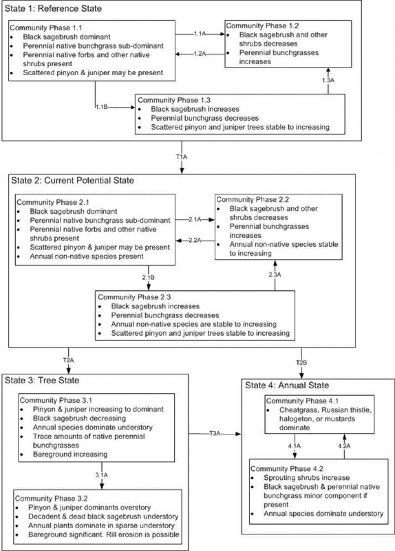
Where management results in abusive livestock use, Douglas rabbitbrush, shadscale, threadleaf snakeweed and galleta increase, while Indian ricegrass, desert needlegrass, and palatable forbs and shrubs decrease. Cheatgrass and annual forbs are likely to invade this site. Shadscale is recognized as a seral community dominant after fire or other disturbance to the black sagebrush community at the lower elevation and precipitation range of this site. Utah juniper and/or singleleaf pinyon readily increase on this site where it occurs adjacent to these woodlands.
Fire Effects:
Black sagebrush communities generally lack enough fine fuels to carry a fire. In addition to low fine fuel loading, wide shrub spacing makes fire infrequent or difficult to prescribe in black sagebrush types. Black sagebrush is highly susceptible to fire-caused mortality; plants are readily killed by all fire intensities. Following burning, reestablishment occurs through off-site sources. Fire effects on Stansbury cliffrose are variable. Fire may kill or severely damage plants. Late-season fire also increases the risk of mortality. Stansbury cliffrose is a weak sprouter that is generally killed by severe fire. Nevada ephedra generally sprouts after fire damages aboveground vegetation. Underground regenerative structures commonly survive when aboveground vegetation is consumed by fire. However, severe fires may kill shallowly buried regenerative structures. Green ephedra generally sprouts vigorously from the roots or woody root crown after fire and rapidly produces aboveground biomass from surviving meristematic tissue. Desert needlegrass has persistent dead leaf bases, which make it susceptible to burning. Fire removes the accumulation; a rapid, cool fire will not burn deep into the root crown. Indian ricegrass can be killed by fire, depending on severity and season of burn. Indian ricegrass reestablishes on burned sites through seed dispersed from adjacent unburned areas. Galleta is a rhizomatous perennial which can resprout after top-kill by fire.
State and transition model

Figure 3. DRAFT STM

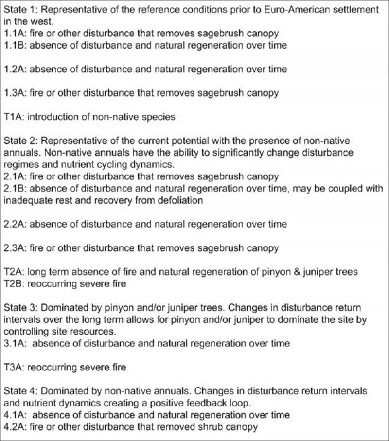
Figure 4. DRAFT STM LEGEND
More interactive model formats are also available.
View Interactive Models
More interactive model formats are also available.
View Interactive Models
Click on state and transition labels to scroll to the respective text
State 1 submodel, plant communities
State 1
Reference State
Community 1.1
Reference Plant Community
The reference plant community is dominated by black sagebrush and desert needlegrass. Potential vegetative composition is about 45% grasses, 5% forbs, and 50% shrubs and trees. Approximate ground cover (basal and crown) is 10 to 20 percent.
Figure 5. Annual production by plant type (representative values) or group (midpoint values)
Table 5. Annual production by plant type
| Plant type | Low (lb/acre) |
Representative value (lb/acre) |
High (lb/acre) |
|---|---|---|---|
| Shrub/Vine | 96 | 215 | 333 |
| Grass/Grasslike | 90 | 203 | 315 |
| Forb | 10 | 22 | 35 |
| Tree | 4 | 10 | 17 |
| Total | 200 | 450 | 700 |
State 2
Current Potential State
State 3
Tree State
State 4
Annual State
Additional community tables
Table 6. Community 1.1 plant community composition
| Group | Common name | Symbol | Scientific name | Annual production (lb/acre) | Foliar cover (%) | |
|---|---|---|---|---|---|---|
|
Grass/Grasslike
|
||||||
| 1 | Primary Perennial Grasses | 158–271 | ||||
| desert needlegrass | ACSP12 | Achnatherum speciosum | 113–158 | – | ||
| Indian ricegrass | ACHY | Achnatherum hymenoides | 45–90 | – | ||
| James' galleta | PLJA | Pleuraphis jamesii | 0–23 | – | ||
| 2 | Secondary Perennial Grasses | 9–68 | ||||
| little Parish's needlegrass | ACPAD | Achnatherum parishii var. depauperatum | 2–14 | – | ||
| Scribner needlegrass | ACSC11 | Achnatherum scribneri | 2–14 | – | ||
| threeawn | ARIST | Aristida | 2–14 | – | ||
| squirreltail | ELEL5 | Elymus elymoides | 2–14 | – | ||
| needle and thread | HECO26 | Hesperostipa comata | 2–14 | – | ||
| muttongrass | POFE | Poa fendleriana | 2–14 | – | ||
| Sandberg bluegrass | POSE | Poa secunda | 2–14 | – | ||
|
Forb
|
||||||
| 3 | Perennial | 9–36 | ||||
| globemallow | SPHAE | Sphaeralcea | 2–14 | – | ||
| threeawn | ARIST | Aristida | 2–7 | – | ||
| 4 | Annual | 0–14 | ||||
|
Shrub/Vine
|
||||||
| 5 | Primary Shrubs | 145–272 | ||||
| black sagebrush | ARNO4 | Artemisia nova | 113–158 | – | ||
| Stansbury cliffrose | PUST | Purshia stansburiana | 23–68 | – | ||
| banana yucca | YUBA | Yucca baccata | 0–23 | – | ||
| Nevada jointfir | EPNE | Ephedra nevadensis | 4–12 | – | ||
| mormon tea | EPVI | Ephedra viridis | 5–11 | – | ||
| 6 | Secondary Shrubs | 23–68 | ||||
| Bigelow sage | ARBI3 | Artemisia bigelovii | 2–23 | – | ||
| fourwing saltbush | ATCA2 | Atriplex canescens | 2–23 | – | ||
| shadscale saltbush | ATCO | Atriplex confertifolia | 2–23 | – | ||
| Apache plume | FAPA | Fallugia paradoxa | 2–23 | – | ||
| winterfat | KRLA2 | Krascheninnikovia lanata | 2–23 | – | ||
| wild crab apple | PERA4 | Peraphyllum ramosissimum | 2–23 | – | ||
|
Tree
|
||||||
| 7 | Evergreen | 4–28 | ||||
| Utah juniper | JUOS | Juniperus osteosperma | 2–14 | – | ||
| singleleaf pinyon | PIMO | Pinus monophylla | 2–14 | – | ||
| Apache plume | FAPA | Fallugia paradoxa | 2–7 | – | ||
| wild crab apple | PERA4 | Peraphyllum ramosissimum | 2–7 | – | ||
| bud sagebrush | PIDE4 | Picrothamnus desertorum | 2–7 | – | ||
Interpretations
Animal community
Livestock Interpretations:
This site is suited for livestock grazing. Grazing management should be keyed to desert needlegrass, indian ricegrass, and perennial grass production. Desert needlegrass produces considerable basal foliage and is good forage while young. Young desert needlegrass is palatable to all classes of livestock. Mature herbage is moderately grazed by horses and cattle but rarely grazed by sheep. Indian ricegrass is highly palatable to all classes of livestock in both green and cured condition. It supplies a source of green feed before most other native grasses have produced much new growth. and fair forage for domestic sheep. Although not preferred, all classes of livestock may use galleta when it is dry. Domestic sheep show greater use in winter than summer months and typically feed upon central portions of galleta tufts, leaving coarser growth around the edges. Galleta may prove somewhat coarse to domestic sheep. In winter, at lower elevations, black sagebrush is heavily utilized by domestic sheep. Stansbury cliffrose is an important browse species for livestock, especially in the winter. Green ephedra is heavily browsed by livestock on winter range but only moderately or lightly browsed during other seasons. Nevada ephedra is important winter range browse for domestic cattle, sheep and goats.
Stocking rates vary over time depending upon season of use, climate variations, site, and previous and current management goals. A safe starting stocking rate is an estimated stocking rate that is fine tuned by the client by adaptive management through the year and from year to year.
Wildlife Interpretations:
Black sagebrush is a significant browse species within the Intermountain region. It is especially important on low elevation winter ranges in the southern Great Basin, where extended snow free periods allow animal’s access to plants throughout most of the winter. In these areas it is heavily utilized by pronghorn and mule deer. Stansbury cliffrose is an important browse species for mule deer, pronghorn, game birds, and songbirds. Wild ungulates use it heavily in winter. Green ephedra is an important browse species for big game animals. Green ephedra is heavily used by wildlife on winter ranges. Mule deer, bighorn sheep, and pronghorn browse Nevada ephedra, especially in spring and late summer when new growth is available. Desert needlegrass and Indian ricegrass are important forage species for several wildlife species.
Hydrological functions
Runoff is medium. Permeability is rapid.
Recreational uses
Aesthetic value is derived from the diverse floral and faunal composition and the colorful flowering of wild flowers and shrubs during the spring and early summer. This site offers rewarding opportunities to photographers and for nature study. This site is used for hiking and has potential for upland and big game hunting.
Other products
Triterpenoids extracted from Stansbury cliffrose have been shown to have inhibitory effects on HIV and Epstein-Barr virus. Native Americans used the inner bark for making clothing and ropes, and the branches for making arrows. Native Americans used Nevada ephedra as a tea to treat stomach and kidney ailments. Indian ricegrass was traditionally eaten by some Native Americans. The Paiutes used seed as a reserve food source.
Other information
Black sagebrush is an excellent species to establish on sites where management objectives include restoration or improvement of domestic sheep, pronghorn, or mule deer winter range.
Desert needlegrass seeds are easily germinated and have potential for commercial use. Green ephedra is listed as a successful shrub for restoring western rangeland communities and can be used to rehabilitate disturbed lands. It also has value for reducing soil erosion on both clay and sandy soils. Stansbury cliffrose is recommended for wildlife, roadside, construction, and mine spoils plantings; and for restoring pinyon-juniper woodland, mountain brushland, basin big sagebrush grassland, black sagebrush, and black greasewood communities. It can be established on disturbed seedbeds by broadcast seeding, drill seeding, or transplanting. Fall or winter seeding is recommended. Nevada ephedra is useful for erosion control, and seedlings have been successfully planted onto reclaimed strip mines, with survival ranging from 12 to 94%. Atrazine may be effective in controlling Nevada ephedra, though some plants can survive through crown sprouting. Irrigation may increase control by atrazine. Green ephedra establishes readily through direct seeding, transplants, and stem cuttings. Desert needlegrass may be used for groundcover in areas of light disturbance, but it is susceptible to excessive trampling.
Supporting information
Type locality
| Location 1: Lincoln County, NV | |
|---|---|
| Township/Range/Section | T3 R62 S35 |
| Latitude | 37° 38′ 35″ |
| Longitude | 115° 0′ 0″ |
| General legal description | NW¼ Section 35, T3S. R62E. MDBM. About 10 miles south of Panaca, Cedar Range, Lincoln County, Nevada. |
Other references
Fire Effects Online (http://www.fs.fed.us/database/feis/)
USDA-NRCS Plants Database (Online; http://www.plants.usda.gov
Contributors
RRK
Rangeland health reference sheet
Interpreting Indicators of Rangeland Health is a qualitative assessment protocol used to determine ecosystem condition based on benchmark characteristics described in the Reference Sheet. A suite of 17 (or more) indicators are typically considered in an assessment. The ecological site(s) representative of an assessment location must be known prior to applying the protocol and must be verified based on soils and climate. Current plant community cannot be used to identify the ecological site.
| Author(s)/participant(s) | |
|---|---|
| Contact for lead author | State Rangeland Management Specialist. |
| Date | 11/01/1988 |
| Approved by | |
| Approval date | |
| Composition (Indicators 10 and 12) based on | Annual Production |
Indicators
-
Number and extent of rills:
-
Presence of water flow patterns:
-
Number and height of erosional pedestals or terracettes:
-
Bare ground from Ecological Site Description or other studies (rock, litter, lichen, moss, plant canopy are not bare ground):
-
Number of gullies and erosion associated with gullies:
-
Extent of wind scoured, blowouts and/or depositional areas:
-
Amount of litter movement (describe size and distance expected to travel):
-
Soil surface (top few mm) resistance to erosion (stability values are averages - most sites will show a range of values):
-
Soil surface structure and SOM content (include type of structure and A-horizon color and thickness):
-
Effect of community phase composition (relative proportion of different functional groups) and spatial distribution on infiltration and runoff:
-
Presence and thickness of compaction layer (usually none; describe soil profile features which may be mistaken for compaction on this site):
-
Functional/Structural Groups (list in order of descending dominance by above-ground annual-production or live foliar cover using symbols: >>, >, = to indicate much greater than, greater than, and equal to):
Dominant:
Sub-dominant:
Other:
Additional:
-
Amount of plant mortality and decadence (include which functional groups are expected to show mortality or decadence):
-
Average percent litter cover (%) and depth ( in):
-
Expected annual annual-production (this is TOTAL above-ground annual-production, not just forage annual-production):
-
Potential invasive (including noxious) species (native and non-native). List species which BOTH characterize degraded states and have the potential to become a dominant or co-dominant species on the ecological site if their future establishment and growth is not actively controlled by management interventions. Species that become dominant for only one to several years (e.g., short-term response to drought or wildfire) are not invasive plants. Note that unlike other indicators, we are describing what is NOT expected in the reference state for the ecological site:
-
Perennial plant reproductive capability:
Print Options
Sections
Font
Other
The Ecosystem Dynamics Interpretive Tool is an information system framework developed by the USDA-ARS Jornada Experimental Range, USDA Natural Resources Conservation Service, and New Mexico State University.
Click on box and path labels to scroll to the respective text.