
Natural Resources
Conservation Service
Ecological site R029XY046NV
SANDY LOAM 5-8 P.Z.
Accessed: 04/30/2025
General information
Provisional. A provisional ecological site description has undergone quality control and quality assurance review. It contains a working state and transition model and enough information to identify the ecological site.

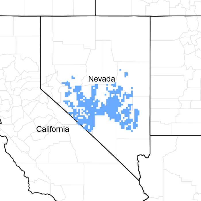
Figure 1. Mapped extent
Areas shown in blue indicate the maximum mapped extent of this ecological site. Other ecological sites likely occur within the highlighted areas. It is also possible for this ecological site to occur outside of highlighted areas if detailed soil survey has not been completed or recently updated.
Associated sites
R029XY016NV |
LOAMY UPLAND 5-8 P.Z. |
---|---|
R029XY017NV |
LOAMY 5-8 P.Z. |
R029XY020NV |
SILTY 5-8 P.Z. |
R029XY042NV |
COARSE SILTY 5-8 P.Z. |
Similar sites
R029XY048NV |
OUTWASH PLAIN More productive site; LECI4 dominant grass |
---|---|
R029XY012NV |
SANDY 5-8 P.Z. KRLA2 not codominant |
R029XY016NV |
LOAMY UPLAND 5-8 P.Z. GRSP dominant shrub |
R029XY080NV |
SHALLOW SANDY LOAM 5-8 P.Z. MESP2 codominant shrub; ACHY dominant grass; less productive site |
R029XY042NV |
COARSE SILTY 5-8 P.Z. KRLA2 dominant shrub |
R029XY020NV |
SILTY 5-8 P.Z. Less productive site; KRLA2 dominant plant |
R029XY017NV |
LOAMY 5-8 P.Z. ATCO dominant shrub |
Table 1. Dominant plant species
Tree |
Not specified |
---|---|
Shrub |
(1) Atriplex canescens |
Herbaceous |
(1) Achnatherum hymenoides |
Physiographic features
This site occurs on inset fans and on axial-stream floodplains of basin floors. Slopes range from 0 to 15 percent, but slope gradients of 0 to 8 percent are typical. Elevations are 4400 to about 7000 feet.
Table 2. Representative physiographic features
Landforms |
(1)
Inset fan
(2) Flood plain |
---|---|
Flooding duration | Very brief (4 to 48 hours) |
Flooding frequency | Rare |
Elevation | 1,341 – 2,134 m |
Slope | 0 – 15% |
Aspect | Aspect is not a significant factor |
Climatic features
The climate associated with this site is arid, characterized by cool, moist winters and hot, dry summers. Average annual precipitation is 5 to 8 inches. Mean annual air temperature is 53 to 59 degrees F. The average growing season is about 140 to 200 days.
Table 3. Representative climatic features
Frost-free period (average) | 200 days |
---|---|
Freeze-free period (average) | 0 days |
Precipitation total (average) | 203 mm |
Figure 2. Monthly average minimum and maximum temperature
Influencing water features
There are no influencing water features associated with this site.
Soil features
The soils of this site are typically deep to very deep and well to excessively well drained. These soils have coarse textured surfaces (sandy loams, loamy sands). Water infiltration is moderate to moderately rapid, available water capacity is low. The soils have an ochric epipedon. The soils are usually dry, but are moist during winter and early spring and for 10 to 20 cumulative days between July and September due to summer convection storms. The soils have a typic aridic soil moisture regime and a mesic temperature regime. Soils associated with this site include: Belcher, Eastgate, Fang, Koyen, Leo, Lyx, Panacker, Papoose, Quina, Roic, Sundown, and Univega.
Table 4. Representative soil features
Surface texture |
(1) Sandy loam (2) Gravelly sandy loam (3) Gravelly fine sand |
---|---|
Family particle size |
(1) Loamy |
Drainage class | Well drained to excessively drained |
Permeability class | Moderate to moderately rapid |
Soil depth | 183 – 213 cm |
Surface fragment cover <=3" | 0% |
Surface fragment cover >3" | 0 – 7% |
Available water capacity (0-101.6cm) |
2.03 – 12.95 cm |
Calcium carbonate equivalent (0-101.6cm) |
0 – 30% |
Electrical conductivity (0-101.6cm) |
0 – 4 mmhos/cm |
Sodium adsorption ratio (0-101.6cm) |
0 – 12 |
Soil reaction (1:1 water) (0-101.6cm) |
7.9 – 9 |
Subsurface fragment volume <=3" (Depth not specified) |
5 – 45% |
Subsurface fragment volume >3" (Depth not specified) |
0 – 9% |
Ecological dynamics
Where management results in abusive use by cattle and/or feral horses, Douglas' rabbitbrush, galleta and exotic annuals increase on the site as fourwing saltbush, winterfat and Indian ricegrass decrease. With continued abusive use, galleta may also decrease. Species likely to invade this site are cheatgrass, Russian thistle and other annuals.
Fire Ecology:
Salt-desert shrub communities with fourwing saltbush historically experienced infrequent, stand-replacement fires. Fire top-kills or kills fourwing saltbush, depending upon ecotype. Fourwing saltbush may sprout after top-kill. Fourwing saltbush probably establishes primarily from seed after fire, with some populations also regenerating vegetatively. Winterfat is either killed or top-killed by fire, depending on fire severity. Severe fire can kill the perennating buds located several inches above the ground surface and thus kills the plant. In addition, severe fire usually destroys seed on the plant. Low-severity fire scorches or only partially consumes the aboveground portions of winterfat and thus does not cause high mortality. Budsage is killed by fire. Indian ricegrass can be killed by fire, depending on severity and season of burn. Indian ricegrass reestablishes on burned sites through seed dispersed from adjacent unburned areas.
State and transition model

Figure 3. DRAFT STM

Figure 4. DRAFT STM LEGEND
More interactive model formats are also available.
View Interactive Models
More interactive model formats are also available.
View Interactive Models
Click on state and transition labels to scroll to the respective text
Ecosystem states
State 1 submodel, plant communities
State 1
Reference State
Community 1.1
Reference Plant Community
The reference plant community is dominated by fourwing saltbush, winterfat and Indian ricegrass. Other important species for this site are spiny hopsage, bud sagebrush, galleta, sand dropseed and spike dropseed. Potential vegetative composition is about 45% grasses, 5% forbs, and 50% shrubs. Approximate ground cover (basal and crown) is 15 to 25 percent.
Figure 5. Annual production by plant type (representative values) or group (midpoint values)
Table 5. Annual production by plant type
Plant type | Low (kg/hectare) |
Representative value (kg/hectare) |
High (kg/hectare) |
---|---|---|---|
Shrub/Vine | 168 | 280 | 392 |
Grass/Grasslike | 151 | 252 | 353 |
Forb | 17 | 28 | 39 |
Total | 336 | 560 | 784 |
State 2
Current Potenital State
State 3
Annual State
Additional community tables
Table 6. Community 1.1 plant community composition
Group | Common name | Symbol | Scientific name | Annual production (kg/hectare) | Foliar cover (%) | |
---|---|---|---|---|---|---|
Grass/Grasslike
|
||||||
1 | Primary Perennial Grasses | 236–353 | ||||
Indian ricegrass | ACHY | Achnatherum hymenoides | 224–280 | – | ||
James' galleta | PLJA | Pleuraphis jamesii | 1–45 | – | ||
squirreltail | ELEL5 | Elymus elymoides | 11–28 | – | ||
2 | Secondary Perennial Grasses | 11–45 | ||||
threeawn | ARIST | Aristida | 3–17 | – | ||
King's eyelashgrass | BLKI | Blepharidachne kingii | 3–17 | – | ||
needle and thread | HECO26 | Hesperostipa comata | 3–17 | – | ||
sand dropseed | SPCR | Sporobolus cryptandrus | 3–17 | – | ||
Forb
|
||||||
3 | Perennial | 6–28 | ||||
James' galleta | PLJA | Pleuraphis jamesii | 0–45 | – | ||
globemallow | SPHAE | Sphaeralcea | 6–28 | – | ||
milkvetch | ASTRA | Astragalus | 3–11 | – | ||
4 | Annual | 1–28 | ||||
Indian ricegrass | ACHY | Achnatherum hymenoides | 224–280 | – | ||
squirreltail | ELEL5 | Elymus elymoides | 11–28 | – | ||
needle and thread | HECO26 | Hesperostipa comata | 3–17 | – | ||
sand dropseed | SPCR | Sporobolus cryptandrus | 3–17 | – | ||
Shrub/Vine
|
||||||
5 | Primary Shrubs | 191–353 | ||||
fourwing saltbush | ATCA2 | Atriplex canescens | 112–168 | – | ||
winterfat | KRLA2 | Krascheninnikovia lanata | 56–112 | – | ||
spiny hopsage | GRSP | Grayia spinosa | 11–28 | – | ||
6 | Secondary Shrubs | 28–56 | ||||
shadscale saltbush | ATCO | Atriplex confertifolia | 6–17 | – | ||
yellow rabbitbrush | CHVI8 | Chrysothamnus viscidiflorus | 6–17 | – | ||
Nevada jointfir | EPNE | Ephedra nevadensis | 6–17 | – | ||
desert-thorn | LYCIU | Lycium | 6–17 | – | ||
horsebrush | TETRA3 | Tetradymia | 6–17 | – | ||
yucca | YUCCA | Yucca | 6–17 | – |
Interpretations
Animal community
Livestock Interpretations:
This site is suited to livestock grazing. Grazing management should be keyed to Indian ricegrass, fourwing saltbush, and winterfat production. Indian ricegrass has good forage value for domestic sheep, cattle and horses. It supplies a source of green feed before most other native grasses have produced much new growth. Fourwing saltbush is one of the most palatable shrubs in the West. Its protein, fat, and carbohydrate levels are comparable to alfalfa. It provides nutritious forage for all classes of livestock. Palatability is rated as good for domestic sheep and domestic goats; fair for cattle; fair to good for horses in winter, poor for horses in other seasons. Winterfat is an important forage plant for livestock, especially during winter when forage is scarce. Abusive grazing practices have reduced or eliminated winterfat on some areas even though it is fairly resistant to browsing. Effects depend on severity and season of grazing.
Stocking rates vary over time depending upon season of use, climate variations, site, and previous management goals. A safe starting stocking rate is an estimated stocking rate that is fine tuned by the client by adaptive management throught the year and from year to year.
Wildlife Interpretations:
Fourwing saltbush provides valuable habitat and year-round browse for wildlife. Fourwing saltbush also provides browse and shelter for small mammals. Additionally, the browse provides a source of water for black-tailed jackrabbits in arid environments. Granivorous birds consume the fruits. Wild ungulates, rodent and lagomorphs readily consume all aboveground portions of the plant. Palatability is rated good for deer, elk, pronghorn and bighorn sheep. Winterfat is an important forage plant for wildlife, especially during winter when forage is scarce. Winterfat seeds are eaten by rodents and are a staple food for black-tailed jackrabbit. Mule deer and pronghorn antelope browse winterfat. Winterfat is used for cover by rodents and is potential nesting cover for upland game birds, especially when grasses grow up through its crown. Indian ricegrass is an important forage species for several wildlife species.
Hydrological functions
Runoff is slow. Permeability is moderate to moderately rapid.
Recreational uses
Aesthetic value is derived from the diverse floral and faunal composition and the colorful flowering of wild flowers and shrubs during the spring and early summer. This site offers rewarding opportunities to photographers and for nature study. This site is used for camping and hiking and has potential for upland and big game hunting.
Other products
Fourwing saltbush is traditionally important to Native Americans. They ground the seeds for flour. The leaves, placed on coals, impart a salty flavor to corn and other roasted food. Top-growth produces a yellow dye. Young leaves and shoots were used to dye wool and other materials. The roots and flowers were ground to soothe insect bites. Indian ricegrass was traditionally eaten by some Native Americans. The Paiutes used seed as a reserve food source.
Other information
Fourwing saltbush is widely used in rangeland and riparian improvement and reclamation projects, including burned area recovery. It is probably the most widely used shrub for restoration of winter ranges and mined land reclamation. Winterfat adapts well to most site conditions, and its extensive root system stabilizes soil. However, winterfat is intolerant of flooding, excess water, and acidic soils. Indian ricegrass is well-suited for surface erosion control and desert revegetation although it is not highly effective in controlling sand movement.
Supporting information
Type locality
Location 1: Nye County, NV | |
---|---|
Township/Range/Section | T8N R53E S14 |
UTM zone | N |
UTM northing | 4267720 |
UTM easting | 589140 |
Latitude | 38° 33′ 12″ |
Longitude | 115° 58′ 37″ |
General legal description | SE¼NW¼ Section 14, T8N. R53E. MDBM. About 4 miles northwest of Black Rock Summit along USHwy 6, Big Sand Springs Valley, Nye County, Nevada. This site also occurs in Esmeralda County, Nevada. |
Other references
Fire Effects Information System (Online; http://www.fs.fed.us/database/feis/plants/)
USDA-NRCS Plants Database (Online; http://www.plants.usda.gov)
Contributors
HA/GED/VWM
Rangeland health reference sheet
Interpreting Indicators of Rangeland Health is a qualitative assessment protocol used to determine ecosystem condition based on benchmark characteristics described in the Reference Sheet. A suite of 17 (or more) indicators are typically considered in an assessment. The ecological site(s) representative of an assessment location must be known prior to applying the protocol and must be verified based on soils and climate. Current plant community cannot be used to identify the ecological site.
Author(s)/participant(s) | P. NOVAK-ECHENIQUE |
---|---|
Contact for lead author | State Rangeland Management Specialist |
Date | 07/12/2012 |
Approved by | |
Approval date | |
Composition (Indicators 10 and 12) based on | Annual Production |
Indicators
-
Number and extent of rills:
None -
Presence of water flow patterns:
Water flow patterns none to rare. -
Number and height of erosional pedestals or terracettes:
Pedestals and terracettes are none. -
Bare ground from Ecological Site Description or other studies (rock, litter, lichen, moss, plant canopy are not bare ground):
Bare Ground ± 50%, depending on amount of rock fragments. -
Number of gullies and erosion associated with gullies:
None -
Extent of wind scoured, blowouts and/or depositional areas:
None -
Amount of litter movement (describe size and distance expected to travel):
Fine litter (foliage from grasses and annual & perennial forbs) expected to move distance of slope length (< 3 m) during intense summer storms. Persistent litter (large woody material) will remain in place except during large rainfall events. -
Soil surface (top few mm) resistance to erosion (stability values are averages - most sites will show a range of values):
Soil stability values should be 1 to 4 on the moderately coarse soil textures typically found on this site. (This will be field tested.) -
Soil surface structure and SOM content (include type of structure and A-horizon color and thickness):
Surface structure is typically single grain or medium platy. Soil surface colors are pale browns or light grayish browns and soils are typified by an ochric epipedon. Organic matter of the surface 2 to 3 inches is typically 1 to 1.5 percent dropping off quickly below. Organic matter content can be more or less depending on micro-topography. -
Effect of community phase composition (relative proportion of different functional groups) and spatial distribution on infiltration and runoff:
Perennial herbaceous plants (especially deep-rooted perennial grasses [i.e., big galleta & Indian ricegrass] slow runoff and increase infiltration. Shrub canopy and associated litter break raindrop impact and provide opportunity for snow catch and accumulation on site. -
Presence and thickness of compaction layer (usually none; describe soil profile features which may be mistaken for compaction on this site):
None. Subsoil argillic horizons and duripans should not be mistaken for compaction. -
Functional/Structural Groups (list in order of descending dominance by above-ground annual-production or live foliar cover using symbols: >>, >, = to indicate much greater than, greater than, and equal to):
Dominant:
Deep-rooted, cool season, perennial bunchgrasses > salt-desert shrubs (i.e., fourwing saltbush, winterfat, spiny hopsage)Sub-dominant:
deep-rooted perennial forbs > warm season, rhizomatous perennial grasses >> associated shrubs > warm season, perennial bunchgrasses > shallow-rooted, cool season, annual forbsOther:
Additional:
-
Amount of plant mortality and decadence (include which functional groups are expected to show mortality or decadence):
Dead branches within individual shrubs common and standing dead shrub canopy material may be as much as 30% of total woody canopy; some of the mature bunchgrasses (±20%) have dead centers. -
Average percent litter cover (%) and depth ( in):
Reference Plant Community: Under canopy and between plant interspaces (20-30%) and depth of litter is <¼ inch. -
Expected annual annual-production (this is TOTAL above-ground annual-production, not just forage annual-production):
For normal or average growing season (March-June) ± 500 lbs/ac; Late summer moisture affects production of warm season grasses -
Potential invasive (including noxious) species (native and non-native). List species which BOTH characterize degraded states and have the potential to become a dominant or co-dominant species on the ecological site if their future establishment and growth is not actively controlled by management interventions. Species that become dominant for only one to several years (e.g., short-term response to drought or wildfire) are not invasive plants. Note that unlike other indicators, we are describing what is NOT expected in the reference state for the ecological site:
Potential invaders on this site include red brome, Russian thistle, cheatgrass, and annual mustards. -
Perennial plant reproductive capability:
All functional groups should reproduce in average (or normal) and above average growing season years. Little to no reproduction occurs during years of below average precipitation.
Print Options
Sections
Font
Other
The Ecosystem Dynamics Interpretive Tool is an information system framework developed by the USDA-ARS Jornada Experimental Range, USDA Natural Resources Conservation Service, and New Mexico State University.
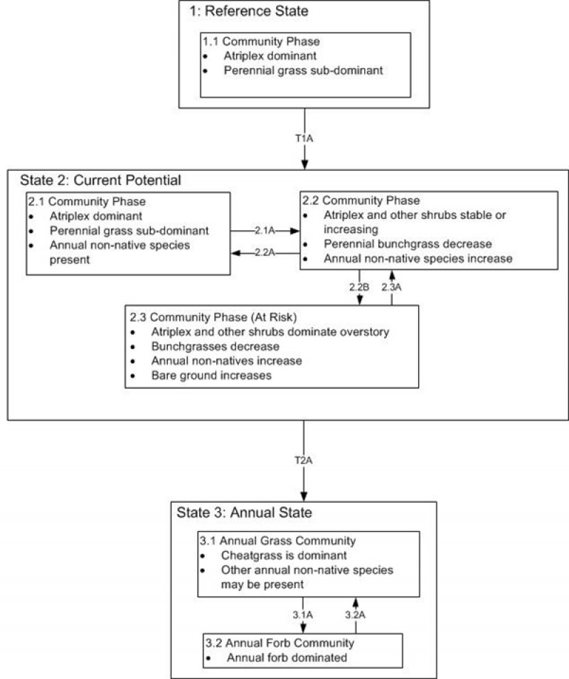
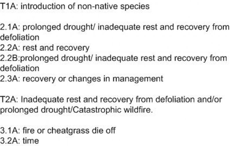
Click on box and path labels to scroll to the respective text.