Provisional. A provisional ecological site description has undergone quality control and quality assurance review. It contains a working state and transition model and enough information to identify the ecological site.
Areas shown in blue indicate the maximum mapped extent of this ecological site. Other ecological sites likely occur within the highlighted areas. It is also possible for this ecological site to occur outside of highlighted areas if detailed soil survey has not been completed or recently updated.
MLRA notes
Major Land Resource Area (MLRA): 030X–Mojave Basin and Range
MLRA Description:
Major Land Resource Area (MLRA) 30, Mojave Desert, is found in southern California, southern Nevada, the extreme southwest corner of Utah and northwestern Arizona within the Basin and Range Province of the Intermontane Plateaus. The climate of the area is hot and dry with mostly hyperthermic and thermic soil temperature regimes and typic-aridic soil moisture regimes. Mean annual air temperatures are between 59-68 degrees F (15-20 C) with average summer maximum temperatures between 100-115 degrees F (38-46 C) and average winter minimum temperatures between 32-59 degrees F (0-15 C). This MLRA is within the arid climate zone however steep elevational gradients contribute to microclimates where semi-arid [mean annual precipitation is greater than 8 inches (200mm)] and hyper-arid [mean annual precipitation is less than 4 inches (100mm)] islands exist. Elevations range from below sea level to over 12,000 feet (3650 meters) in the higher mountain areas. Generally above 5,000 feet, soil temperature regimes can be mesic, cryic and frigid with soil moisture regimes being xeric or ustic. Orographic effects and low elevations can create hyper-arid conditions where the soil moisture regime is aridic-aridic. Due to the extreme elevational range found within this MLRA, land resource units (LRUs) were designated to group areas within the MLRA into similar land units.
LRU Description:
The arid climate zone (XB in ESD ID) LRU is found across the eastern half of California, much of the mid-elevations of Nevada, the southernmost portions of western Utah, and the mid-elevations of northwestern Arizona. Elevations range from 1800-5000 feet and precipitation ranges from 4-8 inches/year. Precipitation is bi-modal for most of the Mojave with precipitation occurring in winter and summer. Areas west of the 117 degree W meridian near Barstow, CA receive precipitation mainly during the winter months (Hereford et al. 2004). The soil temperature regimes are hyperthermic and thermic with a typic-aridic soil moisture regime. Vegetation includes creosote bush (Larrea tridentata), burrobush (Ambrosia dumosa), Mojave yucca (Yucca schidigera) Joshua tree (Yucca brevifolia), chollas, cactus, big galleta grass (Pleuraphis rigida) and several other warm season grasses. At the upper portions of the LRU, where the mean annual precipitation is between 6 to 8 inches (150-200 mm), plant production and diversity are greater and blackbrush (Coleogyne ramosissima) is a common dominant shrub.
Classification relationships
U.S. National Vegetation Classification (USNVC): 3 Desert and Semi-Desert, 3.A Warm Semi-Desert Scrub and Grassland, 3.A.1 Warm Semi-Desert Scrub and Grassland, D039 North America Warm Desert Scrub and Grassland, M088 Mojave-Sonoran Semi-Desert Scrub, G295 Sonoran-Mojave Creosotebush- White Bursage Desert Scrub Group, CEGL005145 Larrea tridentata Shrubland.
This site occurs on fan remnants and alluvial fans on all exposures. Slopes range from 0 to 15 percent, but slope gradients of 2 to 8 percent are typical. Elevations range from 500 to about 3800 feet.
Table 2. Representative physiographic features
Landforms
(1) Fan remnant (2) Alluvial fan
Flooding duration
Very brief (4 to 48 hours) to brief (2 to 7 days)
Flooding frequency
Very rare to rare
Ponding frequency
None
Elevation
500–3,800 ft
Slope
15%
Aspect
Aspect is not a significant factor
Climatic features
The climate of the Mojave Desert has extreme fluctuations of daily temperatures, strong seasonal winds, and clear skies. The climate is arid and is characterized with cool, moist winters and hot, dry summers. Most of the rainfall occurs between November and April. Summer convection storms, from July to September, may contribute up to 25 percent of the annual precipitation. The relative humidity is low, evaporation is high, the percentage of sunshine is high and the daily and seasonal range in temperatures is wide. Average annual precipitation is 3 to 5 inches. Mean annual air temperature is 65 to 76 degrees F. The average growing season is approximately 240 to 360 days.
Average monthly precipitation (inches) at the Las Vegas airport climate station (264436) is: Jan. 0.50, Feb. 0.57, Mar. 0.43, Apr. 0.20, May 0.14, Jun. 0.07, Jul. 0.43, Aug. 0.45, Sept. 0.33, Oct. 0.27, Nov. 0.36. Dec. 0.41. Total annual precipitation is 4.15 inches.
Table 3. Representative climatic features
Frost-free period (average)
360 days
Freeze-free period (average)
0 days
Precipitation total (average)
5 in
Bar
Line
Figure 2. Monthly average minimum and maximum temperature
Influencing water features
Influencing water features are not associated with this site.
Soil features
The soils associated with this site are typically very deep and are derived from mixed sources. Desert pavement is common. The soils are well to excessively drained, available water capacity is low to medium and runoff is very low or low. The soils typically have an ochric epipedon and a calcic horizon. The soil moisture regime is typic aridic and the soil temperature regime is hyperthermic. Limy soils found within this site generally have low organic matter, high alkalinity and a coarse texture. The soil series associated with this site include: Arizo, Baseline, Carrizo, Cheme, Eastland, Gilo, Govwash, Gypwash, Heleweiser, Huevi, Knob Hill, Nickel, Riverbend, Sweetspring, Teebar, Tencee, Underton, Vace, Varwash, Wechech, and Weiser.
A representative soil series is Varwash, a sandy-skeletal, mixed, hyperthermic Typic Haplocalcids. An ochric epipedon occurs from the soil surface to 4 inches and a calcic horizon occurs from 4 to 60 inches.
Desert pavement is common throughout this ecological site. The formation of desert pavement is a function of the deposition of eolian material and mechanical weathering. These surfaces form over hundreds of thousands of years. Salt-rich fine material is deposited in fractures of basaltic bedrock. As the sediments accumulate, wetting and drying causes shrinking and swelling of the clay, resulting in mechanical weathering. These shrinking and swelling cycles cause increased fracturing and displacement of the basaltic clasts vertically and laterally (McFadden et al. 1987). As the process continues, more eolian sediments are deposited between the clasts and migrate downward, further separating them from the underlying bedrock. Thus, these pavements are created and maintained at the soil surface. An important component of pavement development, and the soil beneath, is the formation of a vesicular (Av) horizon. Vesicular horizons are unique in that pores are not interconnected, which results in slow infiltration rates (Yonovitz and Drohan 2009).
Well-developed desert pavements can require thousands of years to form (Graham et al. 2008). Even at maturity, pavement surfaces are characterized by a dynamic stability. Stone mobility is an important aspect of pavement longevity. Disturbances can also be repaired by this process if not too extensive (Haff and Werner 1996). Natural mechanisms influencing stone mobility include animal movement and running water.
Table 4. Representative soil features
Surface texture
(1) Gravelly fine sandy loam
(2) Very gravelly loamy sand
(3) Very gravelly loamy coarse sand
Family particle size
(1) Loamy
Drainage class
Well drained to excessively drained
Permeability class
Rapid to very rapid
Soil depth
72–84 in
Surface fragment cover <=3"
15–65%
Surface fragment cover >3"
2–15%
Available water capacity (0-40in)
3–5.3 in
Calcium carbonate equivalent (0-40in)
5–25%
Electrical conductivity (0-40in)
16 mmhos/cm
Sodium adsorption ratio (0-40in)
10
Soil reaction (1:1 water) (0-40in)
7.9–8.4
Subsurface fragment volume <=3" (Depth not specified)
10–65%
Subsurface fragment volume >3" (Depth not specified)
15%
Ecological dynamics
This creosotebush site is extensive throughout the Mojave Desert and consists of both long and short-lived perennial species. Creosotebush is a native, drought tolerant, evergreen perennial. In stable, old communities, individual creosotebush or clones may attain ages of several thousand years. Creosotebush persists throughout the successional process, but dominates in late successional communities due to its low recruitment and mortality rates.
Defoliation and branch death of creosotebush may occur as a result of long periods of intense moisture stress. Flowering and seed development is directly related to moisture availability, flowering generally occurs in the spring but can occur at any time during the summer if it receives enough rain (Marshall 1995). Creosotebush can produce essential resources (root exudates, leaves, sap, nectar, pollen and seeds) during almost every year of its long life. Germination is related to rainfall and recruitment events are infrequent. The root system of creosotebush consists of a shallow tap root and an extensive system of lateral roots. Sinker roots that originate from lateral roots can penetrate through breaks in cemented soil horizons to extract water during drought in order to maintain physiologically viable tissue water potentials. Consequently, the species is ecologically reliable and supports the lives of many desert animals (Pavlik 2008).
In this system, the clast cover is the dominant control of water and sediment distribution (Wood et al. 2005). Depth of soil water movement is strongly tied to surface clast distribution. Due to the high percentage of surface clasts and fine grained materials of the vesicular horizon, desert pavement sites experience minimal infiltration. Runoff is increased by this process, leading to maximum infiltration and deeper leaching when surface water reaches islands of vegetation on the landscape (Graham et al. 2008). Soils under desert pavements also have high concentrations of nitrate near the surface (Graham et al. 2008). These accumulations are largely a function of desert pavement hydrology. Since infiltration is severely impeded, soils underneath desert pavements experience minimum leaching and salts in the upper soil profile remain there. Nitrate is highly soluble, therefore it is quickly used by plants and excess nitrate is promptly leached away in moist soils. Researchers assume the high salinity and lack of available moisture beneath desert pavement prevent plant roots from accessing the nitrate stored there (Graham et al. 2008).
The frost-free season can last for the better part of a year. However, vegetation is limited by nutrient availability. Nutrient availability in the Mojave Desert is characterized by resource pulses. High temperatures and relatively small rainfall events allow nutrients to accumulate during extended dry periods when plant and microbial growth is restricted. When rainfall events do occur, they trigger biological activities including plant growth and nutrient uptake (Collins et al. 2008). Resource pulse availability is strongly correlated to the presence of microbiotic crusts in arid systems. Microbiotic crusts fix both carbon and nitrogen, and can be considered functional resource reserves. These reserves have lower activation thresholds in relation to water availability than plants, creating nonlinear ecosystem interactions (Collins et al. 2008). This relationship facilitates plant growth in arid environments and allows plants to utilize nutrients that would otherwise remain unavailable during small precipitation events. Nutrient availability in arid systems is also influenced by “resource islands”, also called “islands of fertility”. Resource islands refer to the ability of plants, particularly long-lived perennial shrubs, to increase organic matter and nutrient cycling beneath their canopy. In addition to altering the edaphic environment, these islands provide important habitat for animals, birds, reptiles, and insects (Bainbridge 2007).
Surface disturbance may reduce plant cover, density and diversity and increase erosion on this site. These changes can be very subtle or extremely obvious depending on the intensity and rate of use and an assortment of environmental factors (topography, rainfall, soil type). Desert pavement formed as a function of eolian erosion and deposition, therefore the site is not vulnerable to wind erosion if surface clasts are intact. If disturbed, the fine grained materials of the vesicular horizon will be released into the air potentially causing ecological and health problems (Yonovitz and Drohan 2009). Anthropogenic disturbances disrupt the pavement surface and increase erosion. However, studies have shown that soil functions related to pore morphology are not significantly affected by disturbance. Characteristics of the vesicular horizon, including the non-connected nature of the pores and its effect on restricting infiltration are able to rapidly recover to pre-disturbance conditions (Yonovitz and Drohan 2009). The implications of this are that the increased availability of nitrogen will not facilitate increased vegetative growth because infiltration will continue to be impeded even following disturbance. Creosotebush, after physical damage, has the ability to resprout from axillary buds hidden in the bark of the woody stems (Gibson et al. 2003). Destructive impacts such as land clearing can reduce long-lived creosotebush. The opportunistic perennials such as rayless goldenhead (ACSP), white burrobush (HYSA), and wire lettuce (STEPH) will increase. With a loss of perennial cover, non-native annual grasses and forbs such as red brome (BRRU2), Mediterranean grass (SCBA), and redstem filaree (ERCI6) will readily invade this site.
Fire Ecology:
Prior to Euro-American settlement, fire regimes in Mojave Desert shrub communities were characterized by relatively infrequent, stand-replacing fires with return intervals in the range of 35 years to several centuries. Mojave Desert communities are typically unaffected by fire because of low fuel loads, although a year of exceptionally heavy winter rains can generate fuels by producing a heavy stand of annual forbs and grasses. Plant species, native to the Mojave Desert, produce very little biomass, and communities generally have large interspaces, characteristics which are not conducive for carrying fire across the landscape. When fires do occur, the effect on the ecosystem may be extreme due to the harsh environment and the slow rate of recovery.
An altered fire regime can be detrimental to native plants that are not adapted to a frequent fire return interval. Fire can increase resource availability by reducing the amount of resources (moisture, nutrients) used by resident vegetation through mortality or injury (Zouhar et al. 2008). This increased resource availability can make the ecosystem more susceptible to invasions by non-natives. Relative competitive ability post-fire controls the invasibility of a system. Often non-natives have superior competitive ability for resources such as water, nutrients and light. Creosotebush foliage is resinous and very flammable, and even low severity fires result in high mortality (Marshall 1995). White bursage and creosotebush possess limited sprouting ability, thus can be killed by fire. White bursage, however, can rapidly re-establish from off-site seed. Range ratany generally reproduces sexually from seed, but has also been known to sprout post-fire (Griffith 1991). Damage to big galleta from fire varies. If big galleta is dry, damage may be severe. However, when plants are green, fire will tend to be less severe and damage may be minimal, with big galleta recovering quickly.
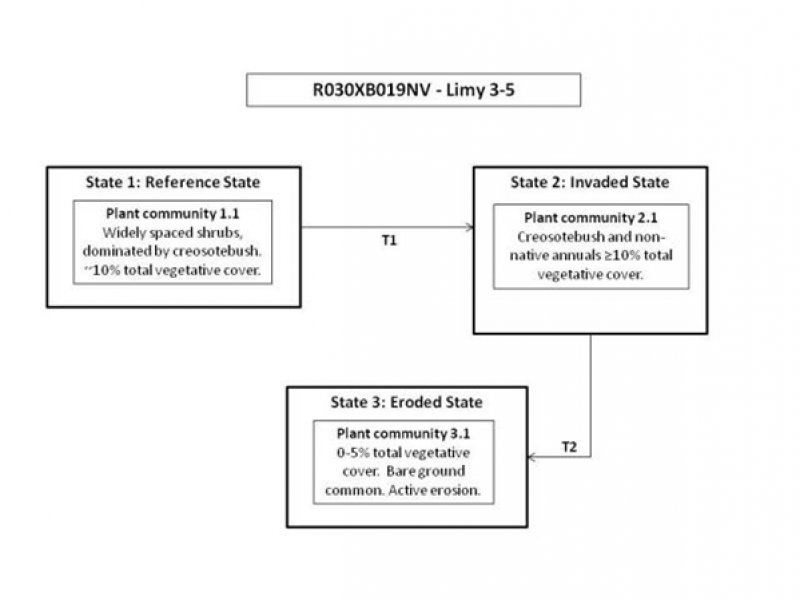
This state is representative of the natural range of variability prior to Euro-American settlement conditions. Plant community phase changes are primarily driven by long-term drought. Insect attack and wildfire are infrequent, but have long-term impacts on the plant community. The reference state is depicted by one general community phase. This community is characterized by dynamic stability. It is stable and long-lived, but is dynamic in response to changes in disturbance regimes and weather patterns.
Community 1.1 Reference Plant Community
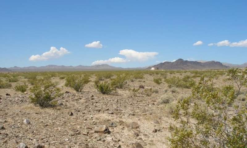
Figure 4. reference plant community
The reference community phase is dominated by creosotebush. Other species include white bursage, range ratany and big galleta. Perennial grasses and forbs are sparse. In wet years, annual forbs are common, especially desert Indianwheat (PLOV). Potential vegetative composition is 90 percent shrubs with approximately 5 percent grasses, 5 percent annual and perennial forbs. Approximate ground cover (basal and crown) is less than 10 percent. Although the total vegetative cover is quite low, bare ground is not abundant. Desert pavement is common and important for soil stability. Desert pavement is characterized by dynamic stability, small scale disturbances can self-repair by natural processes (Haff and Werner 1996). Prolonged drought will result in an overall reduction in the plant community.
Figure 5. Annual production by plant type (representative values) or group (midpoint values)
Table 5. Annual production by plant type
Plant type
Low (lb/acre)
Representative value (lb/acre)
High (lb/acre)
Shrub/Vine
67
113
180
Forb
4
6
10
Grass/Grasslike
4
6
10
Total
75
125
200
Figure 6. Plant community growth curve (percent production by month). NV3001, Mojave Desert, Creosotebush white bursage. Growth begins in spring if sufficient moisture is present from the previous winter. Dormancy occurs with hot summer temperatures and soil moisture is depleted. Some species will break summer dormancy if late summer convection storms bring adequate moisture..
Jan
Feb
Mar
Apr
May
Jun
Jul
Aug
Sep
Oct
Nov
Dec
J
F
M
A
M
J
J
A
S
O
N
D
0
5
25
35
25
0
0
5
5
0
0
0
State 2 Invaded State
The invaded state is characterized by the presence of non-native species. Compositionally, State 2 is similar to the reference state with a trace of non-natives in the understory. The presence of non-native annuals such as red brome, Mediterranean grass, and red-stem filaree reduce ecological resistance and resilience, making it more difficult for this state to recover following a disturbance. Non-natives annuals are highly flammable and promote wildfires where fires historically have been infrequent. Creosotebush persists through invasion by non-native annuals, but the other shrubs and desirable grasses suffer from increased competition and may be removed from the system.
Community 2.1 Plant Community Phase 2.1
This community phase is compositionally similar to the reference community phase with the presence of non-native species in the understory. Ecological processes such as; nutrient cycling, energy capture and soil hydrology are not compromised at this time. However, non-natives are favored and will increase if disturbance frequency varies from the historic range of variation. Total vegetative cover will increase slightly due to the presence of non-native annuals. This plant community is identified as “at risk”. Surface disturbances contributing to the introduction of non-natives may also damage desert pavement, increasing bare ground and decreasing ecological resistance and resilience, leaving the site susceptible to increased erosion. Non-natives provide a continuous bed of fine fuels increasing susceptibility to wildfire. Prolonged drought will result in an overall reduction in the plant community, including non-natives.
State 3 Eroded State
The Eroded State is characterized by reduced vegetative cover, loss of desert pavement and increased bare ground. Persistent and severe surface disturbance, reduced soil moisture and active soil loss prevents establishment and recovery of long-lived native perennials and desert pavement through natural processes. Non-native annuals are of tolerant degraded conditions.
Community 3.1 Plant Community Phase 3.1
This community phase is characterized by low vegetative cover and reduced surface gravels. Non-natives are present in the plant community. Severe reduction or loss of deep-rooted native perennials reduces organic matter inputs and infiltration rates. These changes affect water availably, resistance to erosion and plant production. Damage to desert pavement releases fine-grained materials of the vesicular horizon, causing soil loss. Rain, wind, and surface water all contribute to increased erosion. Prolonged drought will lead to further reduction of the plant community, increasing susceptibility to erosion.
Transition 1 State 1 to 2
Trigger: Introduction of non-native species.
Slow variables: Surface disturbance, changes in the kinds of animals and their grazing patterns, drought and/or changes in fire history that altered the recruitment rate of native species.
Threshold: Non-native species cannot be easily removed from the system and have the potential to significantly alter disturbance regimes from their historic range of variation. Changes in the herbaceous understory, associated with the introduction of non-native annuals, and decreased cover of desert pavement, reduce ecological resistance and resilience following a disturbance.
Transition 2 State 2 to 3
Trigger: Catastrophic event (ex: wildfire, land clearing, drought, heavy rain event) that removes or kills existing perennial vegetation.
Slow variables: Persistent surface disturbances such as; off-highway vehicle use, military operations, changes in the kinds or grazing animals and their grazing patterns, or settlements that damage desert pavement, remove existing perennial vegetation and alter recruitment rates of native species.
Threshold: Severe reduction or loss of deep-rooted native perennials leads to changes in energy flow, soil hydrology and nutrient cycling. Decreased infiltration and increased runoff reduces soil stability contributing to erosion and soil loss.
Additional community tables
Table 6. Community 1.1 plant community composition
Livestock Interpretations:
This site has limited value for livestock grazing because of low forage production and limited water availability. White bursage is of intermediate forage value. It is fair to good forage for horses and fair to poor for cattle and sheep. However, because there is often little other forage where white bursage grows, it is often highly valuable to browsing animals in the winter months. It is sensitive to over browsing and will decrease in cover. Nutrient content of white bursage fluctuates seasonally, causing browsing pressure to fluctuate seasonally, as well. Studies have shown crude protein to be the highest in the late winter at 10 percent, declining the rest of the year to 4 to 7 percent (Hanley et al. 1977). Creosotebush is unpalatable to livestock. The leaves of creosotebush contain antimicrobial phototoxins that provide a defense against a variety of damaging agents. Toxicity of these chemicals is enhanced by exposure to light (Downum et al. 1989). Consumption of creosotebush may be fatal to sheep. Range ratany is an important forage species for all classes of livestock. It is rated fair to good for cattle and sheep. However, under heavy grazing pressure it will decrease.
Stocking rates vary over time depending upon season of use, climate variations, site, and previous and current management goals. A safe starting stocking rate is an estimated stocking rate, fine-tuned by the client through adaptive management throughout the year and from year to year.
Wildlife Interpretations:
A large compliment of wildlife species, including many bird, small mammal and reptile species depend on or at least partially utilize Mojave Warm Desert Scrub habitat.
This key habitat is critical to the survival of the federal and state threatened desert tortoise in Nevada. Desert tortoises often place their burrows directly under creosote bushes, taking advantage of the substrate stability created by the creosote roots. Similarly, large kit fox den complexes are often found in association with creosote habitat for the same reason. Desert reptiles, amphibians and other wildlife use creosotebush as a food source, a perch site and hibernate or estivate in burrows under it. The burrows provide a place to raise young and also allow wildlife to avoid predators and excessive daytime temperatures.
A host of additional heat-tolerant reptile species are also dependent on this habitat; lizards include the desert iguana, desert horned lizards, western whiptails, zebra-tailed lizards and side blotched lizards. Snakes include the spotted leafnosed snake, rosy boa, Western diamondback, Mojave and sidewinder rattlesnakes. The rocky slopes of many of southern Nevada’s mountain ranges within the Mojave/Sonoran Warm Desert Scrub are critical to the survival of the Nelson bighorn sheep subspecies.
Mammalian predators common to this site include the American badger, bobcat, coyote, kit fox and the occasional mountain lion (cougar); all of which utilize small mammals and other wildlife as a source of prey. Small mammals common to this site include antelope ground squirrels; Merriams, Panamint, and desert kangaroo rats; grasshopper and deer mice; black-tailed jackrabbits. Desert kangaroo rats and the desert pocket mouse depend on wind-blown sandy areas associated with this habitat type. Creosote seeds make up a large part of the desert pocket mouse’s diet. These small mammals, and others, are an important prey source for snakes as well as various bird species; including the burrowing owl and loggerhead shrike. Additional avian predators such as the American kestrel, great horned owls, and Ferruginous-legged and red-tail hawks are found throughout the area. Sparsely vegetated creosote and saltbush areas are home to the Le Conte’s thrasher. Other birds occurring on this site include common ravens, horned larks, rock wrens, great roadrunners, black-throated and sage sparrows and raptors.
White bursage is an important browse species for wildlife. Browsing pressure may be particularly heavy in years of low precipitation, when availability of winter annuals is limited. Mule deer browse range ratany year-long with seasonal peaks. Mule deer peak use is from February to April and from August to October. The intricately branched round shape of range ratany also provides valuable shelter for small mammals and birds.
Insects associated with this ecological site provide a significant foraging resource for bats. Typical bat species include: Allen’s big eared, big brown, California leaf-nosed, California myotis, fringed myotis, spotted, hoary, Townsend’s big eared, Western pipistrelle, Western small footed myotis, as well as, other bat species which are seasonally present. Bats utilize caves and crevices in rock formations, along with old mining shafts and tunnels for roost sites. Seasonal use of roost structures may depend on temperature and elevation. However, this site does not provide a significant source of roosting sites.
Drastic changes in the plant community composition, soil properties and disturbance regimes associated with this ecological site may affect the limited perennial water sources found in the Mojave desert. These water sources provide habitat for a variety fish species unique to the Mojave. The introduction of non-native fish species and the decreasing availability of perennial water have already impacted these fish.
Hydrological functions
Runoff is low to very low. Rills and water flow patterns are rare to none. Gullies are none. Natural drainages occur on steeper slopes. Sparse shrub cover and associated litter aid in infiltration. Hydrologic soil groups are A, B, C, and D.
Recreational uses
Aesthetic value is derived from the diverse floral and faunal composition and the colorful flowering of wild flowers and shrubs during the spring and early summer. This site offers rewarding opportunities for photographers and for nature study.
Other products
This site is located within the home territory of the Moapa Southern Paiute American Indians. Plants play a large role in many different types of Southern Paiute Indians ceremonial and non-ceremonial activites. Creosotebush has been highly valued for its medicinal properties by American Indians. It has been used to treat at least 14 illnesses, including colds. Twigs and leaves may be boiled as tea, steamed, pounded into a powder, pressed into a poultice, or heated into an infusion. White bursage is a host for sandfood (Pholisma sonorae), a parasitic plant with a sweet, succulent, subterranean flowerstalk. Sandfood was a valuable food supply for American Indians. A list of some traditional plants identified by Stoffle et al. (2011) that may be considered culturally sensitive can be found on this ecological site.
Other information
White bursage and creosotebush may be used to revegetate disturbed sites in southwestern deserts. Once established, creosotebush may improve sites for annuals that grow under its canopy by trapping fine soil, organic matter, and symbiont propagules. It may also increase water infiltration and storage.
Supporting information
Type locality
Location 1: Lincoln County, NV
Township/Range/Section
T11S R63E S14
General legal description
Kane Springs Wash area, Lincoln County, Nevada. This site also occurs in Clark and southern Nye Counties, Nevada.
Other references
Bainbridge, D.A. 2007. A Guide for Desert and Dry land Restoration: A new hope for arid lands. Island Press, Washington D.C.
Collins, S.L., R.L. Sinsabaugh, C. Crenshaw, L. Green, A. Porras-Alfaro, M. Stursova and L.H. Zeglin. 2008. Pulse dynamics and microbial processes in aridland ecosystems. J. of Ecology. 96: 413-420.
Downum, K.R., S. Villegas, E. Rodriguez and D.J. Keil. 1989. Plant Photosensitizers: A survey of their occurrence in arid and semiarid plant from North America. J. of Chemical Ecology. 15(1): 345-355.
Fire Effects Information System (Online; http://www.fs.fed.us/database/feis/plants/).
Gibson, A.C., M. Rasoul Sharifi, and P.W. Rundel. 2003. Resprout characteristics of creosote bush (Larrea tridentata) when subjected to repeated vehicle damage. J. of Arid Environments. 57: 411-429.
Graham R.C., D.R. Hirmas, Y.A. Wood, and C. Amrhein. 2008. Large near-surface nitrate pool in soils capped by desert pavement in the Mojave Desert, California. Geology. 36.3: 259-262.
Griffith, R.S. 1991. Krameria parvifolia. In: Fire Effects Information System, [Online]. U.S. Department of Agriculture, Forest Service, Rocky Mountain Research Station, Fire Sciences Laboratory (Producer). Available: http://www.fs.fed.us/database/feis/
Haff, P.K. and B.T. Werner. 1996. Dynamical Processes on Desert Pavements and the Healing of Surficial Disturbances. Quaternary Research. 45: 38-46.
Hanley, Thomas A.; Brady, Ward W. 1977. Seasonal fluctuations in nutrient content of feral burro forages, lower Colorado River Valley, Arizona. Journal of Range Management. 30(5): 370-375.
Marshall, K.A. 1995. Larrea tridentata. In: Fire Effects Information System, [Online]. U.S. Department of Agriculture, Forest Service, Rocky Mountain Research Station, Fire Sciences Laboratory (Producer). Available: http://www.fs.fed.us/database/feis/
McFadden, L.D., S.G. Wells, and M.J. Jerinovich. 1987. Influences of eolian and pedogenic processes on the origin and evolution of desert pavement. Geology. 15: 504-508.
Pavlik, B.M. 2008. The California Deserts: an ecological rediscovery. University of California Press.
Stoffle, R.W., K.A Van Vlack, H.Z. Johnson, P.T. Dukes, S.C. De Sola and K.L. Simmons. 2011. Tribally approved American Indian ethnographic analysis of the proposed Dry Lake solar energy zone. Solar Progtammatic Environmental Impact Statement. Bureau of Applied Research in Anthropology. U of Arizona. Available: http://solareis.anl.gov/documents/ethnographic/EthnographicAnalysis_AmargosaValley.pdf
USDA-NRCS Plants Database (Online; http://www.plants.usda.gov).
Wood, Y.A., R.C. Graham, and S.G. Wells. 2005. Surface control of desert pavement pedologic process and landscape function, Cima volcanic field Mojave Desert, California. Catena. 59: 205-230.
Yonovitz, M. and P.J. Drohan. 2009. Pore morphology characterists of vesicular horizons in undisturbed and disturbed arid soils; implication for arid land management. Soil Use and Management. 25: 293-302.
Zouhar, K., J.K. Smith, and S. Sutherland. 2008. Effect of Fire on Nonnative Invasive Plant and Invasibility of Wildland Ecosystems. USDA Forest Service Gen. Tech. Rep. RMRS-GTR-42-vol. 6.
Contributors
E. Hourihan/ P. Novak-Echenquie HA/RRK/GKB
Rangeland health reference sheet
Interpreting Indicators of Rangeland Health is a qualitative assessment protocol used to
determine ecosystem condition based on benchmark characteristics described in the Reference Sheet. A suite of 17 (or
more) indicators are typically considered in an assessment. The ecological site(s) representative of an assessment
location must be known prior to applying the protocol and must be verified based on soils and climate. Current plant
community cannot be used to identify the ecological site.
Author(s)/participant(s)
P.Novak-Echenique
Contact for lead author
State Rangeland Management Specialist
Date
07/14/2009
Approved by
P.Novak-Echenique
Approval date
Composition (Indicators 10 and 12) based on
Annual Production
Indicators
Number and extent of rills:
Rills are rare to none. Rock fragments armor the soil surface against erosion.
Presence of water flow patterns:
Water flow patterns are none to few. A few may occur in areas recently subject to intense summer rainfall and on steeper slopes. Flow patterns are short (<3m) and stable.
Number and height of erosional pedestals or terracettes:
Pedestals and terracettes are none to rare.
Bare ground from Ecological Site Description or other studies (rock, litter, lichen, moss, plant canopy are
not bare ground):
Bare ground varies depending on amount of rock fragments: 5-25%
Number of gullies and erosion associated with gullies:
None
Extent of wind scoured, blowouts and/or depositional areas:
None
Amount of litter movement (describe size and distance expected to travel):
Litter typically remains in place. Fine litter (foliage from grasses and annual & perennial forbs) is expected to move the distance of slope length during intense summer convection storms or rapid snowmelt events. Persistent litter (large woody material) will remain in place except during large rainfall events.
Soil surface (top few mm) resistance to erosion (stability values are averages - most sites will show a range
of values):
Soil stability values are typically 3 to 4 without canopy cover and 5 to 6 with canopy cover.
Soil surface structure and SOM content (include type of structure and A-horizon color and thickness):
Surface soil structure is typically moderate medium to thick platy. Soil colors are light and soils have an ochric epipedon. Organic matter of the surface 2 to 3 inches is less than 1 percent.
Effect of community phase composition (relative proportion of different functional groups) and spatial
distribution on infiltration and runoff:
Sparse shrub canopy and associated litter provide some protection from raindrop impact and provide limited infiltration.
Presence and thickness of compaction layer (usually none; describe soil profile features which may be
mistaken for compaction on this site):
None. Subsoil calcic or petrocalcic horizons are not to be interpreted as compacted layers.
Functional/Structural Groups (list in order of descending dominance by above-ground annual-production or live foliar
cover using symbols: >>, >, = to indicate much greater than, greater than, and equal to):
Amount of plant mortality and decadence (include which functional groups are expected to show mortality or
decadence):
Dead branches within individual shrubs are common and standing dead shrub canopy material may be as much as 25% of total woody canopy.
Average percent litter cover (%) and depth ( in):
Between plant interspaces 5-15% and depth (±¼-inch).
Expected annual annual-production (this is TOTAL above-ground annual-production, not just forage annual-production):
For normal or average growing season ~125 lbs/ac. Favorable years ~200 lbs/ac and unfavorable years ~75 lbs/ac.
Potential invasive (including noxious) species (native and non-native). List species which BOTH characterize
degraded states and have the potential to become a dominant or co-dominant species on the ecological site if
their future establishment and growth is not actively controlled by management interventions. Species that become
dominant for only one to several years (e.g., short-term response to drought or wildfire) are not invasive
plants. Note that unlike other indicators, we are describing what is NOT expected in the reference state for the
ecological site:
Potential invaders on this site include red brome, red-stem filaree, annual mustards and Mediterranean grass.
Perennial plant reproductive capability:
All functional groups should reproduce in normal and above-normal growing seasons. Little growth or reproduction occurs during extreme drought years.
The Ecosystem Dynamics Interpretive Tool is an information system framework developed by the USDA-ARS Jornada Experimental Range, USDA Natural Resources Conservation Service, and New Mexico State University.
Click on box and path labels to scroll to the respective text.