Natural Resources
Conservation Service
Ecological site R030XB138NV
DRY GRAVELLY WASH 5-7 P.Z.
Last updated: 2/26/2025
Accessed: 04/06/2026
General information
Provisional. A provisional ecological site description has undergone quality control and quality assurance review. It contains a working state and transition model and enough information to identify the ecological site.
MLRA notes
Major Land Resource Area (MLRA): 030X–Mojave Basin and Range
This Major Land Resource Area (MLRA) is in the Basin and Range Province of the Intermontane Plateaus. Most of the MLRA is in the Sonoran Desert Section of this province. The northern third is in the Great Basin Section, and the southeastern part is in the Mexican Highland Section. A small part of the southwest corner is in the Salton Trough Section. Broad basins, valleys, and old lakebeds make up most of the area, but widely spaced mountains trending north to south occur throughout the area. Isolated, short mountain ranges are separated by an aggraded desert plain. The mountains are fault blocks that have been tilted up. Long alluvial fans coalesce with dry lakebeds between some of the ranges. Elevation ranges from 282 feet (85 meters) below sea level, the lowest elevation occurring on dry land in the world, in Badwater Basin in Death Valley to 3,950 feet (1,205 meters) above sea level in valleys and basins. Some mountain ranges have peaks that exceed 11,100 feet (3,385 meters).
The 30XB Land Resource Unit (LRU) is found across the eastern half of California, much of the lower and mid-elevations of Nevada, the southernmost portions of western Utah, and the mid-elevations of northwestern Arizona. Elevations range from 1800 to 5000 feet and precipitation ranges from 4 to 9 inches per year, but is generally between 5 to 6 inches. This LRU is characterized primarily by summer precipitation. Summer precipitation falls between July and September in the form of rain, and winter precipitation falls starting in November and ends between February and March, also mostly in the form of rain; however, it does receive between 0 and 3 inches of snow, with an average of 1 inch. The soil temperature regime is thermic and the soil moisture regime is typic-aridic. Vegetation includes creosotebush (LATR2), white bursage (AMDU2), Nevada ephedra (EPNE), range ratany (KRER) Spanish dagger (YUSC2), Joshua tree (YUBR), cholla (OPUNT), big galleta (PLRI3) and several other warm season grasses. At the upper elevations, plant production and diversity are greater and blackbrush (CORA), sagebrush (ARTEM), and singleleaf pinyon (PIMO) are common. All plant species provided to characterize the broader LRU may or may not be present on a particular ecological site.
Ecological site concept
This site occurs in ephemeral drainageways. Slopes range from 2 to 8 percent. Elevations range from 3000 to 5000 feet. The soils associated with this site are very deep, well drained to somewhat excessively drained, and are formed in alluvium derived from limestone and dolomite.
Please refer to group concept R030XB186CA to view the provisional STM.
Similar sites
| R030XB137NV |
GRAVELLY WASH 5-7 P.Z. PRFA dominant shrub; more productive site |
|---|---|
| R030XB051NV |
UPLAND WASH AMER, PLRI3 dominant species; more productive site |
| R030XB133NV |
GRAVELLY INSET FAN 5-7 P.Z. AMDU2, MESP2, PSFR dominant shrubs; more productive site |
| R030XB132NV |
GRAVELLY WASH 3-5 P.Z. ACGR, PSFR dominant shrubs; more productive site |
Table 1. Dominant plant species
| Tree |
Not specified |
|---|---|
| Shrub |
(1) Psorothamnus fremontii |
| Herbaceous |
(1) Pleuraphis rigida |
Physiographic features
This site occurs in ephemeral drainageways. Slopes range from 2 to 8 percent. Elevations range from 3000 to 5000 feet.
Table 2. Representative physiographic features
| Landforms |
(1)
Drainageway
|
|---|---|
| Flooding duration | Brief (2 to 7 days) |
| Flooding frequency | Occasional |
| Elevation | 3,000 – 5,000 ft |
| Slope | 2 – 8% |
| Aspect | Aspect is not a significant factor |
Climatic features
The climate is hot and arid, with mild winters and very hot summers. Precipitation is greatest in the winter with a lesser secondary peak in summer, typical of the Mojave Desert. Average annual precipitation is 5 to 7 inches. Mean annual air temperature is 63 to 68 degrees F. The average growing season is about 210 to 320 days.
Table 3. Representative climatic features
| Frost-free period (average) | 320 days |
|---|---|
| Freeze-free period (average) | |
| Precipitation total (average) | 7 in |
Figure 1. Monthly average minimum and maximum temperature
Influencing water features
This site is subject to occasional flooding after summer convection storms or during spring runoff.
Soil features
The soils associated with this site are very deep, well drained to somewhat excessively drained, and are formed in alluvium derived from limestone and dolomite. Runoff is negligible to very low and permeability is moderate to moderately rapid. The soils are occasionally flooded. Soils correlated to this site include Colosseum, a sandy-skeletal, carbonatic, thermic Typic Haplocalcid, and Elbowcanyon, a loamy-skeletal, carbonatic, thermic Typic Torriorthent.
Table 4. Representative soil features
| Parent material |
(1)
Alluvium
–
limestone
(2) Alluvium – dolomite |
|---|---|
| Surface texture |
(1) Very gravelly fine sandy loam |
| Family particle size |
(1) Loamy |
| Drainage class | Well drained to somewhat excessively drained |
| Permeability class | Moderate to moderately rapid |
| Soil depth | 72 – 84 in |
| Surface fragment cover <=3" | 80 – 85% |
| Surface fragment cover >3" | 5% |
| Available water capacity (0-40in) |
1.25 – 3.07 in |
| Calcium carbonate equivalent (0-40in) |
30 – 60% |
| Electrical conductivity (0-40in) |
2 mmhos/cm |
| Sodium adsorption ratio (0-40in) |
2 |
| Soil reaction (1:1 water) (0-40in) |
8.2 – 8.4 |
| Subsurface fragment volume <=3" (Depth not specified) |
20 – 60% |
| Subsurface fragment volume >3" (Depth not specified) |
15% |
Ecological dynamics
Please refer to group concept R030XB186CA to view the provisional STM.
Ephemeral streams are unique in that they lack permanent flow although they perform the same critical hydrologic functions as perennial streams; they move water, sediment, nutrients and debris through the stream network and provide connectivity within the watershed. These systems experience extreme and rapid variations in flood magnitudes as a response to heavy rain events. The fundamental difference between ephemeral and perennial streams is that ephemeral stream channels have sizeable transmission losses when they flow. Ephemeral streams are also characterized by wider channels, low sinuosity, and flat bed topography. The sparseness of vegetation along the stream banks contributes to channel widening tendencies. (Levick et al 2008).
Along the desert washes, vegetation composition and structure overlap considerably with those of the surrounding desert uplands. An example of this is creosotebush and white bursage commonly occur in the washes and adjoining uplands. As water availability increases, the vegetation becomes increasingly distinct from the upland vegetation with respect of physiognomy and species composition. Canopy cover increases and mesoriparian and hydroriparian species increase in abundance (Levick et al 2008).
As a result of decreased flow rates in the downstream direction, more silts and fines are deposited in the channel, which can be advantageous to biotic communities. Many of the species (white burrobush, desert rabbitbrush) occurring on this site are generally considered to be increasers or pioneers in the presence of disturbance (Abella 2010). These species produce prolific numbers of wind-dispersed seeds and are more abundant in ephemeral streams with intense flood scour (Levick et al 2008). Rainfall and flood flow events can trigger a pulse of germination of annual and perennial forbs from a diverse soil seed bank. Some species have resprouting capabilities; an adaptation to withstand flooding flows. Fremont dalea also has nitrogen fixing bacteria associated with its roots, which can be an important influence on local nitrogen availability. The increased availability of nutrients on these sites compared to the surrounding area increases the likelihood of encountering invasive species, like saltcedar (Tamarix spp.). Saltcedar is successful in arid environments due to its ability to tolerate unpredictable periods of moisture. Perturbation of these systems by natural or anthropogenic causes can result in the development of continuous incised channels.
Flooding is a natural disturbance. Floods help to redistribute nutrients across the landscape, as well as, encouraging resprouting and seedling establishment. Seedling establishment and canopy expansion is greater for plants growing in the drainageways than the surrounding area. However, these plants are less tolerant of extended dry periods because they are adapted to increased soil moisture (Hamerlynk and McAuliffe 2008). Very large rainfall events rarely occur but have the potential to remove existing vegetation and deposit new sediment, initiating secondary succession.
Ephemeral stream channels are more sensitive to disturbance than their perennial counterparts. Recreational activities, especially OHV use, remove the protective vegetative cover, and change the sediment transport relationship in these systems. Loss of vegetative cover leaves channels more susceptible to entrenchment and channel widening resulting in habitat loss. In order for restoration attempts to succeed, it is important to wait until the system has reached a new dynamic equilibrium. Once the system has stabilized, restoration steps should include removal of disturbance, control of non-natives, and revegetation with native species (Briggs 1996).
Fire Ecology:
Wildfire is infrequent and patchy in this system, however, years with increased annual precipitation result in increased production from annuals and increase the chances of wildfire. Post-fire, creosotebush and other fire intolerant shrubs decrease. Fire tolerant species such as Fremont's dalea, bursage, burrobush and ephedra are able to sprout from the root crown and may increase following wildfire. Fire also favors an increase of perennial native grasses. This site is also susceptible to invasion by non-native species including Tamarix. Tamarix initially established along major drainages in the Southwest deserts but successfully invaded outlying ephemeral waters and springs through windblown seeds and possibly the occasional planting. The deep, extensive root system extends to the water table and is capable of extracting water from unsaturated soil horizons. Tamarix is characterized as a facultative phreatophyte and a halophyte, giving it a competitive advantage over native species in areas where salinities are elevated and water tables are depressed. Non-native annual grasses and forbs will also establish throughout ephemeral stream systems, primarily due to propagule pressure from surrounding uplands.
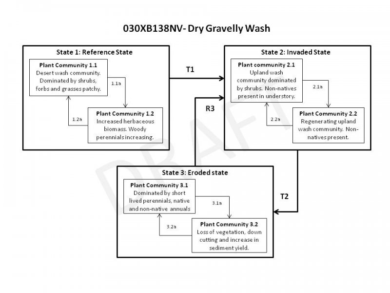
State and transition model
More interactive model formats are also available.
View Interactive Models
More interactive model formats are also available.
View Interactive Models
Click on state and transition labels to scroll to the respective text
Ecosystem states
State 1 submodel, plant communities
State 2 submodel, plant communities
State 3 submodel, plant communities
State 1
Reference State
The reference state is representative of the natural range of variability under pristine conditions. Plant community phase changes are driven by drought, infrequent wildfire, disease, insect attack and occasional flooding in response to heavy rainfall events and has increased available moisture and nutrients. Fire is rare in this system. This ecological site experiences seasonal flooding which is important in redistributing moisture and nutrients throughout the landscape. Plant community dynamics are controlled by interactions between weather patterns and disturbance regimes.
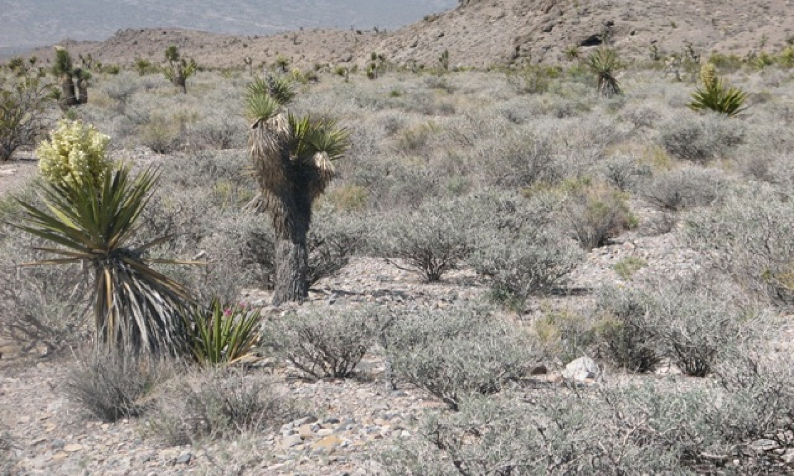
Community 1.1
Reference Plant Community
The reference plant community is characteristic of a healthy, mid to late-seral plant community phase. Dominant plant species include Fremont’s dalea and white burrobush. Nevada ephedra and Encelia species are other important species associated with this ecological site. Potential vegetative composition is about 10 percent grasses, 10 percent forbs and 85 percent shrubs. Approximate ground cover (basal and crown) is 10 to 20 percent. Annual natives are abundant in years with increased spring time precipitation.
Figure 2. Annual production by plant type (representative values) or group (midpoint values)
Table 5. Annual production by plant type
| Plant type | Low (lb/acre) |
Representative value (lb/acre) |
High (lb/acre) |
|---|---|---|---|
| Shrub/Vine | 80 | 200 | 280 |
| Forb | 10 | 25 | 35 |
| Grass/Grasslike | 10 | 25 | 35 |
| Total | 100 | 250 | 350 |
Community 1.2
At Risk Community
This plant community is an early seral post-disturbance community. Initially, herbaceous biomass and short-lived perennials increase. Additional run-in moisture from surrounding landscapes increases the ecological resilience and helps this site recover following a disturbance. Sprouting shrubs quickly recover and provide favorable sites for establishment of other shrub seedlings. Desert almond and Anderson wolfberry commonly sprout from root suckers following flooding and burial by sediment. Mexican bladdersage and ephedra are also capable of sprouting. Species such as brittlebush and white bursage reproduce sexually and are prolific seed producers. This plant community is ‘at-risk’ of invasion by non-native species. Non-natives take advantage of the increased availability of critical resources following a disturbance.
Pathway 1.1a
Community 1.1 to 1.2
Severe seasonal flooding, wildfire, prolonged drought, disease and/or insect attack.
Pathway 1.2a
Community 1.2 to 1.1
Absence from disturbance and natural regeneration over time.
State 2
Invaded State
The invaded state is characterized by the presence of non-native species in the understory. Non-native annuals will persist once introduced into the plant community, due to their annual growth form, abundant seed production and long term seed viability. Non-native annuals such as red brome, redstem filaree and Mediterranean grass are potential invaders on this ecological site. A biotic threshold is crossed with the introduction of non-natives that are difficult to remove from the system and have the potential to alter disturbance regimes significantly from their historic range of variation. Non-native annuals are highly flammable and promote wildfire where fires historically have been infrequent.
Community 2.1
Invaded Plant Community
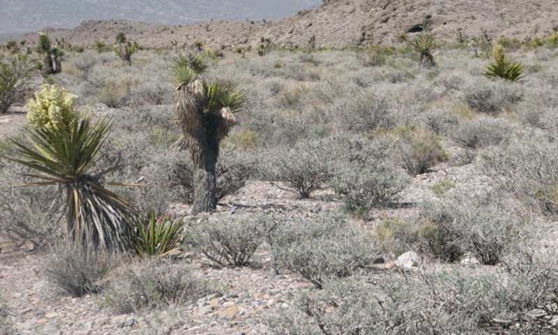
Figure 3. Trace understory of non-natives
This plant community is compositionally similar to the reference plant community with a trace of non-natives in the understory. Ecological processes have not been compromised at this time. However, ecological resilience is reduced by the presence of non-natives and this community phase will respond differently following a disturbance when compared to the reference plant community. Non-natives compete with native species for space, water and critical resources like nitrogen. Fine fuels provided by non-native annuals create a continuous fuel bed, facilitating the spread of fire.
Community 2.2
At Risk Community
This plant community is characteristic of an early seral post-disturbance community. It is heavily dominated by herbaceous biomass, which may or may not be non-native, woody perennials are increasing. Sprouting shrubs quickly recover and provide favorable microsites for establishment of other shrubs. Desert almond, Mexican bladdersage, ephedra and Anderson wolfberry commonly sprout from the root crown following disturbance. This plant community phase is characterized as “at-risk”. The initial decrease in long-lived perennial shrubs reduces the stability of the site, leaving it vulnerable to increased erosion. Management actions to prevent this community phase from cross a irreversible threshold into state 3, include reducing surface disturbances, managing non-natives and protecting remaining native vegetation. Actions could include long-term recreation management.
Pathway 2.1a
Community 2.1 to 2.2
Severe seasonal flooding, prolonged drought, wildfire, disease and/or insect attack.
Pathway 2.2a
Community 2.2 to 2.1
Absence from disturbance and natural regeneration over time.
State 3
Eroded State
The eroded state is characterized by increased erosion and sediment transport, channel entrenchment, and the loss of perennial vegetation. Natural ecosystem processes are disrupted and sediment and nutrients are increasingly redistributed downstream. Feedbacks contributing to the stability of this state include soil erosion, nutrient loss, increased runoff, and decreased infiltration. These feedbacks prevent the establishment of native vegetation and lead to further ecological damage. This state is considered to be hydrologically impaired.
Community 3.1
Eroded Plant Community
This plant community is dominated by short-lived perennial shrubs and non-natives, characteristic of a short disturbance return interval. The ability of this site to dissipate energy during large flow events is severely reduced contributing to ecological damage downstream. Loss of perennial native vegetation has reduced organic mater inputs, accelerating loss of soil stability and erosion by wind and water.
Community 3.2
Eroded Plant Community
This plant community is characterized by a loss of stability, increased erosion, and channel incision. Ecological processes have been altered including connectivity within the watershed, ground water recharge and habitat quality.
Pathway 3.1a
Community 3.1 to 3.2
Large scale disturbance removes remaining perennial shrubs.
Pathway 3.2a
Community 3.2 to 3.1
With time and the exclusion of disturbance some perennial plants return to the system increasing stability.
Transition T1
State 1 to 2
Introduction of non-native species due to combination of factors including: 1) surface disturbance, 2) changes in the kinds of animals and their grazing patterns, 3) drought and/or 4) changes in fire history.
Transition T2
State 2 to 3
Reoccurring disturbance on a short return interval and removal of stabilizing vegetation.
Restoration pathway R3
State 3 to 2
Ecological processes can be restored to the site, but non-natives remain. Possible restoration techniques include stabilizing the site by reestablishing native perennials and the use of erosion control structures to dissipate energy and reestablish the flood plain.
Conservation practices
| Channel Bank Vegetation | |
|---|---|
| Channel Bed Stabilization |
Additional community tables
Table 6. Community 1.1 plant community composition
| Group | Common name | Symbol | Scientific name | Annual production (lb/acre) | Foliar cover (%) | |
|---|---|---|---|---|---|---|
|
Grass/Grasslike
|
||||||
| 1 | Primary perennial grasses | 13–25 | ||||
| Indian ricegrass | ACHY | Achnatherum hymenoides | 1–8 | – | ||
| desert needlegrass | ACSP12 | Achnatherum speciosum | 1–8 | – | ||
| low woollygrass | DAPU7 | Dasyochloa pulchella | 1–8 | – | ||
| squirreltail | ELEL5 | Elymus elymoides | 1–8 | – | ||
| big galleta | PLRI3 | Pleuraphis rigida | 1–8 | – | ||
|
Forb
|
||||||
| 2 | Perennial forbs | 13–25 | ||||
| Cooper's dogweed | ADCO2 | Adenophyllum cooperi | 1–5 | – | ||
| woolly desert marigold | BAPL3 | Baileya pleniradiata | 1–5 | – | ||
| suncup | CAMIS | Camissonia | 1–5 | – | ||
| Indian paintbrush | CASTI2 | Castilleja | 1–5 | – | ||
| desert trumpet | ERIN4 | Eriogonum inflatum | 1–5 | – | ||
| desert globemallow | SPAM2 | Sphaeralcea ambigua | 1–5 | – | ||
| 3 | Annual forbs | 1–25 | ||||
| redroot cryptantha | CRMIM | Cryptantha micrantha var. micrantha | 1–5 | – | ||
| manybristle chinchweed | PEPA2 | Pectis papposa | 1–5 | – | ||
| New Mexico plumeseed | RANE | Rafinesquia neomexicana | 1–5 | – | ||
| wirelettuce | STEPH | Stephanomeria | 1–5 | – | ||
|
Shrub/Vine
|
||||||
| 4 | Primary shrubs | 148–226 | ||||
| Fremont's dalea | PSFR | Psorothamnus fremontii | 88–125 | – | ||
| burrobrush | HYSA | Hymenoclea salsola | 50–75 | – | ||
| brittlebush | ENCEL | Encelia | 5–13 | – | ||
| Nevada jointfir | EPNE | Ephedra nevadensis | 5–13 | – | ||
| 5 | Secondary shrubs | 25–50 | ||||
| burrobush | AMDU2 | Ambrosia dumosa | 3–8 | – | ||
| fourwing saltbush | ATCA2 | Atriplex canescens | 3–8 | – | ||
| brickellbush | BRICK | Brickellia | 3–8 | – | ||
| Mojave rabbitbrush | ERPA29 | Ericameria paniculata | 3–8 | – | ||
| littleleaf ratany | KRER | Krameria erecta | 3–8 | – | ||
| creosote bush | LATR2 | Larrea tridentata | 3–8 | – | ||
| desert pepperweed | LEFR2 | Lepidium fremontii | 3–8 | – | ||
| water jacket | LYAN | Lycium andersonii | 3–8 | – | ||
| desert almond | PRFA | Prunus fasciculata | 3–8 | – | ||
| purple sage | SADO4 | Salvia dorrii | 3–8 | – | ||
| Mexican bladdersage | SAME | Salazaria mexicana | 3–8 | – | ||
| turpentinebroom | THMO | Thamnosma montana | 3–8 | – | ||
| banana yucca | YUBA | Yucca baccata | 3–8 | – | ||
| Joshua tree | YUBR | Yucca brevifolia | 3–8 | – | ||
| Mojave yucca | YUSC2 | Yucca schidigera | 3–8 | – | ||
| beavertail pricklypear | OPBA2 | Opuntia basilaris | 1–3 | – | ||
| Engelmann's hedgehog cactus | ECEN | Echinocereus engelmannii | 1–3 | – | ||
| cottontop cactus | ECPOP | Echinocactus polycephalus var. polycephalus | 1–3 | – | ||
Interpretations
Animal community
Livestock Interpretations: This site is suitable for livestock grazing. However, domestic livestock grazing should be carefully managed to avoid damage to the plant community. Perennial grass species including desert needlegrass, Indian ricegrass, and big galleta are palatable to domestic livestock. However, they account for only five percent of total production and therefore provide a limited forage resource. Nevada ephedra is important to domestic livestock on winter ranges. It is typically browsed heavily without inducing toxicity.
Stocking rates vary over time depending upon season of use, climatic variations, site and previous and current management goals. A safe starting stocking rate is an estimated stocking rate that is fine tuned by the client by adaptive management through the year and from year to year.
Wildlife Interpretations: The microclimates created in and around ephemeral streams provide important wildlife habitats, especially for less mobile species. These areas provide predator protection, breeding and nesting sites, shade, movement corridors, migration stopover sites, and food sources and subsequently support the greatest concentrations of wildlife. The desert tortoise, (Gopherus agassizii) a federally listed species, commonly uses ephemeral washes for travel, excavation or burrows and for feeding (Jennings 1997).
Mule deer and small mammals commonly forage on desert almond. Nevada ephedra is preferred forage for mule deer, bighorn sheep and pronghorn in the spring and late summer when new growth is available. Birds commonly eat ephedra seeds.
Hydrological functions
This site experiences occasional flooding. Rills are none to few. Waterflow patterns are common. Sparse shrub canopy and associated litter break raindrop impact. Perennial herbaceous plants slow runoff and increase infiltration.
Recreational uses
Aesthetic value is derived from the diverse floral and faunal composition and the colorful flowering of wild flowers and shrubs during the spring and early summer. This site offers rewarding opportunities for photography and nature study. This site is suitable for hiking, nature study, photography, and has potential for upland and big game hunting.
Supporting information
Type locality
| Location 1: Clark County, NV | |
|---|---|
| Township/Range/Section | T17S R60E S34 |
| UTM zone | N |
| UTM northing | 4032064 |
| UTM easting | 656989 |
| Latitude | 36° 25′ 15″ |
| Longitude | 115° 14′ 56″ |
| General legal description | Approximately 1.2 miles from Lower White Blotch Spring, near Fossil Ridge. South of the Yucca Forest in the Desert National Wildlife Refuge, Clark County, Nevada. USGS Gass Peak, 7.5 minute topographic quadrangle. Mt. Diablo Meridian |
Other references
Abella, S.R. 2010. Disturbance and plant succession in the Mojave and Sonoran Desert of the American Southwest. Int. J. Environ. Res. Public Health. 7: 1248-1284.
Briggs, M.K. 1996. Riparian Ecosystem Recovery in Arid Lands: Strategies and Reference. University of Arizona Press. Tucson, Arizona.
Fire Effects Information System (Online; http://www.fs.fed.us/database/feis/plants/)
USDA-NRCS Plants Database (Online; http://plants.usda.gov)
Hamerlynck, E.P. and J.R. McAuliffe. 2008. Soil-dependent canopy die-back and plant mortality in two Mojave Desert shrubs. J. of Arid Environments. 72:1793-1802.
Jennings, W.B. 1997. Habitat use and food preferences of the desert tortoise, Gopherus agassizii, in the western Mojave Desert and impacts of off-road vehicles. pp. 42-45 in Proceedings: Conservation, Restoration, and Management of Tortoises and Turtles, an International Conference.
Levick, L.R., D.C Goodrich, M. Hernandez, J. Fonseca, D.J. Semmens, J. Stromberg, M. Tluczek, R.A. Leidy, M. Scianni, D.P. Guertin, and W.G. Kepner. 2008. The Ecological and Hydrological Significance of Ephemeral and Intermittent Streams in the Arid and Semi-arid American Southwest. U.S. Environmental Protection Agency. Office of Research and Development. Washington D.C.
Contributors
E. Hourihan
E.Hourihan
PN-E
Approval
Sarah Quistberg, 2/26/2025
Rangeland health reference sheet
Interpreting Indicators of Rangeland Health is a qualitative assessment protocol used to determine ecosystem condition based on benchmark characteristics described in the Reference Sheet. A suite of 17 (or more) indicators are typically considered in an assessment. The ecological site(s) representative of an assessment location must be known prior to applying the protocol and must be verified based on soils and climate. Current plant community cannot be used to identify the ecological site.
| Author(s)/participant(s) | P.Novak-Echenique |
|---|---|
| Contact for lead author | State Rangeland Management Specialist |
| Date | 06/28/2011 |
| Approved by | Sarah Quistberg |
| Approval date | |
| Composition (Indicators 10 and 12) based on | Annual Production |
Indicators
-
Number and extent of rills:
Rills are none to few. -
Presence of water flow patterns:
Water flow patterns are few to common. They are typically connected. -
Number and height of erosional pedestals or terracettes:
Pedestals are rare with occurrence typically limited to areas within water flow patterns. -
Bare ground from Ecological Site Description or other studies (rock, litter, lichen, moss, plant canopy are not bare ground):
Bare ground up to 10%, depending on amount of surface rock fragments. -
Number of gullies and erosion associated with gullies:
None. -
Extent of wind scoured, blowouts and/or depositional areas:
None. -
Amount of litter movement (describe size and distance expected to travel):
Fine litter (foliage from grasses and annual & perennial forbs) expected to move distance of slope length (<10 ft) during intense summer convection storms or rapid snowmelt events. Persistent litter (large woody material) will remain in place except during large rainfall events. -
Soil surface (top few mm) resistance to erosion (stability values are averages - most sites will show a range of values):
Soil stability values should be 1 to 4 on most soil textures found on this site. (To be field tested.) -
Soil surface structure and SOM content (include type of structure and A-horizon color and thickness):
Surface structure is moderate, very thick platy. Soil surface colors are yellowish brown and soils are typified by an ochric epipedon. Organic matter of the surface 2 to 3 inches is less than 1 percent. -
Effect of community phase composition (relative proportion of different functional groups) and spatial distribution on infiltration and runoff:
Sparse shrub canopy and associated litter break raindrop impact. Perennial herbaceous plants slow runoff and increase infiltration. -
Presence and thickness of compaction layer (usually none; describe soil profile features which may be mistaken for compaction on this site):
None. Platy or massive sub-surface horizons, should not to be interpreted as compacted layers. -
Functional/Structural Groups (list in order of descending dominance by above-ground annual-production or live foliar cover using symbols: >>, >, = to indicate much greater than, greater than, and equal to):
Dominant:
Reference Plant Community: Mojave Desert shrubs >> deep-rooted perennial forbs> deep-rooted, warm-season, bunchgrasses > deep-rooted, cool-season, bunchgrasses > annual forbs > shallow-rooted grasses.Sub-dominant:
Other:
succulents, annual grassesAdditional:
-
Amount of plant mortality and decadence (include which functional groups are expected to show mortality or decadence):
Dead branches within individual shrubs common and standing dead shrub canopy material may be as much as 25% of total woody canopy; mature bunchgrasses commonly (<20%) have dead centers. -
Average percent litter cover (%) and depth ( in):
Between plant interspaces and under canopy up to 20% and depth (<¼-inch). -
Expected annual annual-production (this is TOTAL above-ground annual-production, not just forage annual-production):
For normal or average growing season ±250 lbs/ac. Favorable years 350+ lb/ac and unfavorable years 100 lbs/ac. -
Potential invasive (including noxious) species (native and non-native). List species which BOTH characterize degraded states and have the potential to become a dominant or co-dominant species on the ecological site if their future establishment and growth is not actively controlled by management interventions. Species that become dominant for only one to several years (e.g., short-term response to drought or wildfire) are not invasive plants. Note that unlike other indicators, we are describing what is NOT expected in the reference state for the ecological site:
Potential invaders on this site include red brome, Mediterranean grass, redstem filaree and saltcedar. -
Perennial plant reproductive capability:
All functional groups should reproduce in above-average and average growing season years. Less reproduction will occur in below-average precipitation years. Some functional groups may not grow during below-average years.
Print Options
Sections
Font
Other
The Ecosystem Dynamics Interpretive Tool is an information system framework developed by the USDA-ARS Jornada Experimental Range, USDA Natural Resources Conservation Service, and New Mexico State University.
Click on box and path labels to scroll to the respective text.