Natural Resources
Conservation Service
Ecological site R030XC032NV
UPLAND WASH
Last updated: 2/25/2025
Accessed: 04/03/2026
General information
Provisional. A provisional ecological site description has undergone quality control and quality assurance review. It contains a working state and transition model and enough information to identify the ecological site.
Ecological site concept
This site occurs in ephemeral drainageways. Slope gradients of 4 to 8 percent are most typical. Elevations range from 4000 to 6000 feet. The soils associated with this site are very deep, well drained soils that formed in alluvium derived from limestone. Runoff is low and soils have high saturated hydraulic conductivity. The soils experience occasional flooding for brief periods during spring runoff and during summer convection storms.
Associated sites
| R030XC007NV |
SHALLOW GRAVELLY LOAM 7-9 P.Z. |
|---|---|
| R030XC042NV |
GRAVELLY LOAM 9-11 P.Z. |
Similar sites
| R030XC005NV |
PIEDMONT WASH Less productive, LELA4 & ERNAN5 important species. |
|---|---|
| R030XB051NV |
UPLAND WASH Less productive, AMER & HYMEN3 dominant shrubs. |
| R030XB137NV |
GRAVELLY WASH 5-7 P.Z. Less productive, PSFR & HYSA important shrubs. |
Table 1. Dominant plant species
| Tree |
Not specified |
|---|---|
| Shrub |
(1) Fallugia paradoxa |
| Herbaceous |
(1) Achnatherum hymenoides |
Physiographic features
This site occurs in ephemeral drainageways. Slope gradients of 4 to 8 percent are most typical. Elevations range from 4000 to 6000 feet.
Table 2. Representative physiographic features
| Landforms |
(1)
Drainageway
|
|---|---|
| Flooding duration | Very brief (4 to 48 hours) |
| Flooding frequency | Occasional |
| Elevation | 4,000 – 6,000 ft |
| Slope | 4 – 8% |
Climatic features
The climate is semiarid with cool, moist winters and warm, intermittently moist summers. Precipitation is greatest in the winter with lesser secondary peak in the summer, typical of the Mojave Desert transitional to Great Basin. Average annual precipitation is 7 to 11 inches. Mean annual air temperature is 51 to 57 degrees F. The average growing season is about 130 to 180 days.
Table 3. Representative climatic features
| Frost-free period (average) | 180 days |
|---|---|
| Freeze-free period (average) | |
| Precipitation total (average) | 11 in |
Figure 1. Monthly precipitation range
Figure 2. Monthly average minimum and maximum temperature
Influencing water features
This site is occasionally flooded during spring runoff and summer convection storms.
Soil features
The soils associated with this site are very deep, well drained soils that formed in alluvium derived from limestone. Runoff is low and soils have high saturated hydraulic conductivity. The soils experience occasional flooding for brief periods during spring runoff and during summer convection storms. The soils are characterized by an ochric epipedon and typic-aridic soil moisture regime. Soil series correlated to this site include Quijinump, a loamy-skeletal, carbonatic, mesic Typic Torriorthents.
Table 4. Representative soil features
| Parent material |
(1)
Alluvium
–
limestone
|
|---|---|
| Surface texture |
(1) Extremely gravelly sandy loam (2) Extremely cobbly fine sandy loam (3) Very gravelly fine sandy loam |
| Family particle size |
(1) Loamy |
| Drainage class | Well drained |
| Permeability class | Rapid |
| Soil depth | 60 – 84 in |
| Surface fragment cover <=3" | 35 – 60% |
| Surface fragment cover >3" | 4 – 25% |
| Available water capacity (0-40in) |
1.81 – 4.76 in |
| Calcium carbonate equivalent (0-40in) |
40 – 60% |
| Electrical conductivity (0-40in) |
2 mmhos/cm |
| Sodium adsorption ratio (0-40in) |
5 |
| Soil reaction (1:1 water) (0-40in) |
7.4 – 8.8 |
| Subsurface fragment volume <=3" (Depth not specified) |
20 – 65% |
| Subsurface fragment volume >3" (Depth not specified) |
2 – 20% |
Ecological dynamics
Ephemeral streams are unique in that they lack permanent flow although they perform the same critical hydrologic functions as perennial streams; they move water, sediment, nutrients and debris through the stream network and provide connectivity within the watershed. These systems experience extreme and rapid variations in flood magnitudes as a response to heavy rain events. The fundamental difference between ephemeral and perennial streams is that ephemeral stream channels have sizeable transmission losses when they flow. Ephemeral streams are also characterized by wider channels, low sinuosity, and flat bed topography. The sparseness of vegetation along the stream banks contributes to channel widening tendencies (Levick et al 2008).
Along the desert washes, vegetation composition and structure overlap considerably with those of the surrounding upland sites. As water availability increases, the vegetation becomes increasingly distinct from the upland vegetation with respect of physiognomy and species composition. Canopy cover increases and mesoriparian and hydroriparian species increase in abundance (Levick et al 2008). This ecological site is characterized as having intermediate water availability and supporting more drought-tolerant shrubs.
The topographic position of this site leads to increased moisture availability and higher annual production. The run-in moisture in combination with higher levels of organic matter results in increased ecological resilience. Upland washes play an important role in redistributing nutrients, sediment and water throughout the landscape. Common disturbances consist of short duration flooding during heavy winter or spring precipitation events and summer convection storms. Species dominating this site include Apache plume and desert almond, which commonly sprout from root suckers following flooding and burial by sediment. Prolific seed producers known to thrive on disturbed sites will be common following flooding or other disturbance, such as broom snakeweed and brittlebush. Species likely to invade this site are non-native annuals such as cheatgrass and red brome.
The microclimates created in and around ephemeral streams also provide important wildlife habitats, especially for less mobile species. These areas provide predator protection, breeding and nesting sites, shade, movement corridors, migration stopover sites, and food sources and subsequently support the greatest concentrations of wildlife.
Fire Ecology:
Fires tend to be infrequent in desert riparian communities. Ephemeral drainageways can be susceptible to fires depending on the season. During wet periods, drainageways tend be more resilient to burning due to higher moisture content of the soil and plants. During the dry months, these drainageways can be vulnerable to wildfires depending on plant community composition. Fires that occur in the uplands adjacent to drainageways can pose more of a threat due to increased sedimentation from burned sites. After fire, ephemeral drainageways act as sediment and ash catch basins, as post-fire storms increase runoff and erosion.
Aboveground portions of Apache plume are top-killed by fire. Apache plume exhibits vigorous sprouting from root suckers after top-kill by fire. Desert almond sprouts from rhizomes and/or lignotubers following fire, and becomes abundant on burned sites. Post-fire seedling establishment is rare based on the limited post fire regeneration studies available. Bladdersage is probably top-killed or killed by fire. Severe fires may kill belowground rhizomes. Nevada ephedra generally sprouts after fire damages aboveground vegetation. Underground regenerative structures commonly survive when aboveground vegetation is consumed by fire. However, severe fires may kill shallowly buried regenerative structures. Indian ricegrass can be killed by fire, depending on severity and season of burn. Indian ricegrass reestablishes on burned sites through seed dispersed from adjacent unburned areas. Arid needlegrass is damaged by burning due to the dense plant material that can burn slowly and long, charring to the growing points. Late summer and early fall fires are the least harmful.
State and transition model

More interactive model formats are also available.
View Interactive Models
More interactive model formats are also available.
View Interactive Models
Click on state and transition labels to scroll to the respective text
Ecosystem states
State 1 submodel, plant communities
State 2 submodel, plant communities
State 1
Reference State
The reference state is representative of the natural range of variability under pristine conditions. It is maintained by periodic flooding in response to heavy rainfall events and snowmelt and has increased available moisture and nutrients. Fire is rare in this system. This ecological site experiences seasonal flooding and is important for redistributing moisture and nutrients throughout the landscape.
Community 1.1
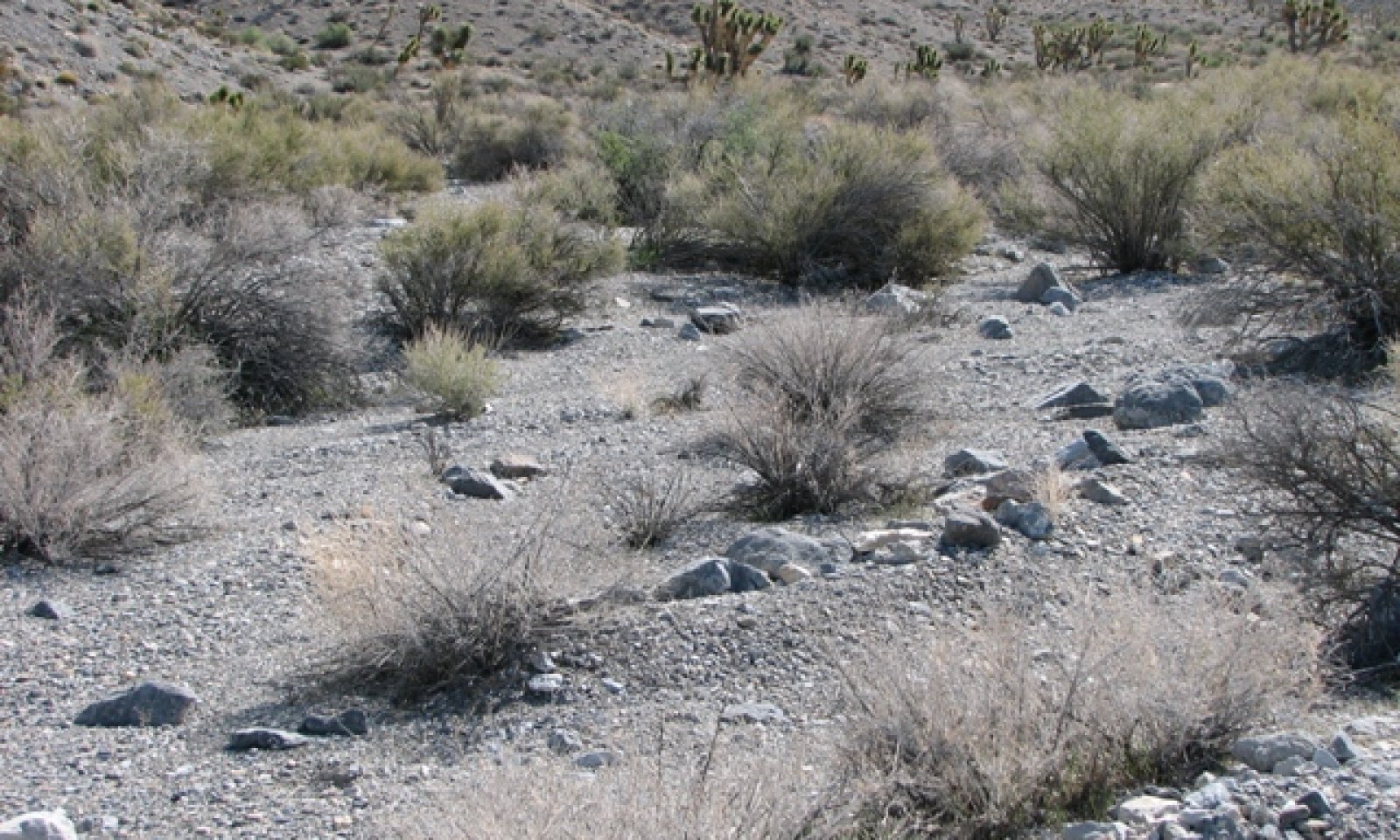
Reference Plant Community

Figure 3. Upland Wash
The reference plant community is dominated by long and short-lived shrubs. Species thriving here include those tolerant of periodic inundation, reproduce vegetatively, or are prolific seed producers. Dominant species include Apache plume, desert almond, Mexican bladdersage, ephedra and Indian ricegrass. Native annuals flourish in the spring while soils are moist. Periods of drought cause die-back among mature woody perennials, decreased annuals and herbaceous vegetation. Potential vegetative composition is about 10 percent grasses, 10 percent annual and perennial forbs and 80 percent shrubs. Approximate ground cover (basal and crown) is 25 to 40 percent.
Figure 4. Annual production by plant type (representative values) or group (midpoint values)
Table 5. Annual production by plant type
| Plant type | Low (lb/acre) |
Representative value (lb/acre) |
High (lb/acre) |
|---|---|---|---|
| Shrub/Vine | 480 | 640 | 800 |
| Forb | 60 | 80 | 100 |
| Grass/Grasslike | 60 | 80 | 100 |
| Total | 600 | 800 | 1000 |
Community 1.2
Plant Community 1.2
This plant community is characteristic of a post-disturbance plant community phase. Initially, it is heavily dominated by herbaceous vegetation and short-lived perennials. Sprouting shrubs quickly recover and provide a favorable environment for establishment of shrub seedlings. Additional run-in moisture from the surrounding landscape increases the ecological resilience and helps this site recover quickly following disturbance.
Pathway 1.1a
Community 1.1 to 1.2
Seasonal flooding, wildfire, disease or insect attack.
Pathway 1.2a
Community 1.2 to 1.1
Absence from disturbance and natural regeneration over time.
State 2
Invaded State
The invaded state is characterized by the presence of non-native species in the understory. A biotic threshold is crossed with the introduction of non-natives that are difficult to remove from the system and have they potential to significantly alter disturbance regimes from their historic range of variation. Non-native annuals will persist once introduced into the plant community, due to their annual growth form, abundant seed production and long term seed viability. Non-native annuals such as red brome and cheatgrass are potential invaders on this ecological site. These non-native annuals are highly flammable and promote wildfires where fires historically have been infrequent.
Community 2.1
Plant Community 2.1
Species composition is similar to the reference plant community. Ecological processes have not been compromised at this time, however, ecological resilience is reduced by the presence of non-natives. This plant community phase will respond differently following disturbance, when compared to the reference plant community. Management focused on decreasing the amount of anthropogenic disturbance is important for maintaining the health of perennial native species that protect the site against erosion.
Community 2.2
Plant Community 2.2
This plant community is characteristic of a post-disturbance plant community. It is dominated by herbaceous vegetation, which may or may not be non-native, woody perennials are increasing. Apache plume and desert almond commonly sprout from root suckers following flooding and burial by sediment. Mexican bladdersage will also sprout from rhizomes following disturbance. Sprouting species provide favorable sites for germination of species such as brittlebush, ratany, and spiny hopsage which reproduce sexually and are prolific seed producers.
Pathway 2.1a
Community 2.1 to 2.2
Seasonal flooding, wildfire, disease or insect attack.
Pathway 2.2a
Community 2.2 to 2.1
Absence from disturbance and natural regeneration over time.
Transition T1
State 1 to 2
Introduction of non-native species due to a combination of factors including: 1) surface disturbance, 2) changes in the kinds of animals and their grazing patterns, 3) drought and/or 4) changes in fire history.
Additional community tables
Table 6. Community 1.1 plant community composition
| Group | Common name | Symbol | Scientific name | Annual production (lb/acre) | Foliar cover (%) | |
|---|---|---|---|---|---|---|
|
Grass/Grasslike
|
||||||
| 1 | Primary Perennial Grasses | 32–80 | ||||
| Indian ricegrass | ACHY | Achnatherum hymenoides | 16–40 | – | ||
| purple threeawn | ARPU9 | Aristida purpurea | 16–40 | – | ||
| 2 | Secondary Perennial Grasses | 16–64 | ||||
| Mormon needlegrass | ACAR14 | Achnatherum aridum | 2–16 | – | ||
| desert needlegrass | ACSP12 | Achnatherum speciosum | 2–16 | – | ||
| low woollygrass | DAPU7 | Dasyochloa pulchella | 2–16 | – | ||
| bush muhly | MUPO2 | Muhlenbergia porteri | 2–16 | – | ||
| James' galleta | PLJA | Pleuraphis jamesii | 2–16 | – | ||
| big galleta | PLRI3 | Pleuraphis rigida | 2–16 | – | ||
|
Forb
|
||||||
| 3 | Perennial Forbs | 20–80 | ||||
| Cooper's dogweed | ADCO2 | Adenophyllum cooperi | 2–24 | – | ||
| milkvetch | ASTRA | Astragalus | 2–24 | – | ||
| desert marigold | BAILE | Baileya | 2–24 | – | ||
| smallseed sandmat | CHPO12 | Chamaesyce polycarpa | 2–24 | – | ||
| Mojave thistle | CIMO | Cirsium mohavense | 2–24 | – | ||
| desert trumpet | ERIN4 | Eriogonum inflatum | 2–24 | – | ||
| Cooper's rubberweed | HYCO2 | Hymenoxys cooperi | 2–24 | – | ||
| beardtongue | PENST | Penstemon | 2–24 | – | ||
| polygala | POLYG | Polygala | 2–24 | – | ||
| brightwhite | PREX | Prenanthella exigua | 2–24 | – | ||
| globemallow | SPHAE | Sphaeralcea | 2–24 | – | ||
| 4 | Annual Forbs | 1–40 | ||||
|
Shrub/Vine
|
||||||
| 5 | Primary Shrubs | 376–600 | ||||
| Apache plume | FAPA | Fallugia paradoxa | 200–280 | – | ||
| desert almond | PRFA | Prunus fasciculata | 120–200 | – | ||
| Mexican bladdersage | SAME | Salazaria mexicana | 40–80 | – | ||
| Nevada jointfir | EPNE | Ephedra nevadensis | 8–20 | – | ||
| mormon tea | EPVI | Ephedra viridis | 8–20 | – | ||
| 6 | Secondary Shrubs | 40–160 | ||||
| Shockley's goldenhead | ACSH | Acamptopappus shockleyi | 8–40 | – | ||
| fourwing saltbush | ATCA2 | Atriplex canescens | 8–40 | – | ||
| blackbrush | CORA | Coleogyne ramosissima | 8–40 | – | ||
| brittlebush | ENCEL | Encelia | 8–40 | – | ||
| spiny hopsage | GRSP | Grayia spinosa | 8–40 | – | ||
| broom snakeweed | GUSA2 | Gutierrezia sarothrae | 8–40 | – | ||
| burrobrush | HYSA | Hymenoclea salsola | 8–40 | – | ||
| littleleaf ratany | KRER | Krameria erecta | 8–40 | – | ||
| desert pepperweed | LEFR2 | Lepidium fremontii | 8–40 | – | ||
| spiny menodora | MESP2 | Menodora spinescens | 8–40 | – | ||
| purple sage | SADO4 | Salvia dorrii | 8–40 | – | ||
| turpentinebroom | THMO | Thamnosma montana | 8–40 | – | ||
| banana yucca | YUBA | Yucca baccata | 8–40 | – | ||
| Joshua tree | YUBR | Yucca brevifolia | 8–40 | – | ||
Interpretations
Animal community
Livestock Interpretation:
This site is suitable for livestock grazing. Grazing management should be keyed to dominant grasses and palatable shrub production. Apache plume is generally considered fair forage for livestock. Apache plume is usually considered low to fair in palatability to livestock. Desert almond is a seasonally important forage species on the dry ranges where it grows. Livestock consume the foliage in the spring and following rainy periods. Bladdersage is grazed only lightly by cattle and horses except on ranges where little other forage is available. Nevada ephedra is important winter range browse for domestic cattle, sheep and goats. Indian ricegrass is highly palatable to all classes of livestock in both green and cured condition. It supplies a source of green feed before most other native grasses have produced much new growth. Arid needlegrass is preferred by horses year round, desired by cattle and sheep in the spring.
Stocking rates vary over time depending upon season of use, climate variations, site, and previous and current management goals. A safe starting stocking rate is an estimated stocking rate that is fine tuned by the client by adaptive management through the year and from year to year.
Wildlife Interpretation:
Reports of Apache-plume's value as food to wildlife vary, but most sources rate it as fair or moderate. There are no references in the literature describing its value as cover for large wildlife, but it does provide cover for small mammals and birds. Mule deer and various small mammals feed on desert almond and/or utilize habitats where desert almond is dominant. Bladdersage is browsed by several different species of wildlife. Mule deer, bighorn sheep, and pronghorn browse Nevada ephedra, especially in spring and late summer when new growth is available. Indian ricegrass is eaten by pronghorn in moderate amounts whenever available. A number of heteromyid rodents inhabiting desert rangelands show preference for seed of Indian ricegrass. Indian ricegrass is an important component of jackrabbit diets in spring and summer. Indian ricegrass seed provides food for many species of birds. Doves, for example, eat large amounts of shattered Indian ricegrass seed lying on the ground. Mule deer and Pronghorn antelope prefer to graze on arid needlegrass during the spring, however it is undesirable during the winter.
Hydrological functions
Runoff is low. Permeability is rapid. Rills are none to rare. Water flow patterns are few to common especially after summer convection storms and spring runoff. Water flow patterns can be connected and long (>10 ft). Sparse shrub canopy and associated litter provide some protection from raindrop impact. Shrub canopy also provides some opportunity for snow catch on this site.
Recreational uses
Aesthetic value is derived from the diverse floral and faunal composition and the colorful flowering of wild flowers and shrubs during the spring and early summer. This site offers rewarding opportunities to photographers and for nature study. This site is used for hiking and has potential for upland and big game hunting.
Other products
Bundles of twigs from Apache plume were used by Native Americans as brooms and older stems for arrow shafts. A concoction from leaves was used as a growth stimulant for hair. Native Americans used Nevada ephedra as a tea to treat stomach and kidney ailments. Indian ricegrass was traditionally eaten by some Native Americans. The Paiutes used the seed as a reserve food source.
Other information
Apache plume's chief value for rehabilitation of disturbed sites is erosion control/soil stabilization, especially under arid or semi-arid conditions. It is valuable for erosion control/soil stabilization because it spreads underground vegetatively. Nevada ephedra is useful for erosion control, and seedlings have been successfully planted on reclaimed strip mines.
Supporting information
Type locality
| Location 1: Clark County, NV | |
|---|---|
| Township/Range/Section | T13S R60E S32 |
| UTM zone | N |
| UTM northing | 40469323 |
| UTM easting | 654542 |
| Latitude | 36° 33′ 2″ |
| Longitude | 115° 5′ 57″ |
| General legal description | Occurs northeast of U.S. Highway 95, near Yellowjacket Canyon, in section 32, T. 13 S., R. 60 E.; USGS Dead Horse Ridge, NV 7.5 minute topographic quadrangle. |
Other references
Fire Effects Information System (Online; http://www.fs.fed.us/database/feis/plants/).
Levick, L.R., D.C Goodrich, M. Hernandez, J. Fonseca, D.J. Semmens, J. Stromberg, M. Tluczek, R.A. Leidy, M. Scianni, D.P. Guertin, and W.G. Kepner. 2008. The Ecological and Hydrological Significance of Ephemeral and Intermittent Streams in the Arid and Semi-arid American Southwest. U.S. Environmental Protection Agency. Office of Research and Development. Washington D.C.
USDA-NRCS Plants Database (Online; http://www.plants.usda.gov).
Contributors
E. Hourihan
PNE/EH
Approval
Sarah Quistberg, 2/25/2025
Rangeland health reference sheet
Interpreting Indicators of Rangeland Health is a qualitative assessment protocol used to determine ecosystem condition based on benchmark characteristics described in the Reference Sheet. A suite of 17 (or more) indicators are typically considered in an assessment. The ecological site(s) representative of an assessment location must be known prior to applying the protocol and must be verified based on soils and climate. Current plant community cannot be used to identify the ecological site.
| Author(s)/participant(s) | P Novak-Echenique |
|---|---|
| Contact for lead author | State Rangeland Management Specialist |
| Date | 04/27/2011 |
| Approved by | Sarah Quistberg |
| Approval date | |
| Composition (Indicators 10 and 12) based on | Annual Production |
Indicators
-
Number and extent of rills:
Rills are none to rare. -
Presence of water flow patterns:
Water flow patterns are few to common, especially after summer convection storms and spring runoff. Water flow patterns are connected and long (>10ft). -
Number and height of erosional pedestals or terracettes:
Pedestals are rare with occurrence typically limited to areas within water flow patterns. -
Bare ground from Ecological Site Description or other studies (rock, litter, lichen, moss, plant canopy are not bare ground):
Bare Ground up to 20% depending on amount of surface rock fragments. -
Number of gullies and erosion associated with gullies:
None -
Extent of wind scoured, blowouts and/or depositional areas:
None -
Amount of litter movement (describe size and distance expected to travel):
Fine litter (foliage from grasses and annual & perennial forbs) expected to move distance of slope length during intense summer convection storms or rapid snowmelt events. Persistent litter (large woody material) will remain in place except during large rainfall events. -
Soil surface (top few mm) resistance to erosion (stability values are averages - most sites will show a range of values):
Soil stability values should be 1 to 4 on most soil textures found on this site. (To be field tested.) -
Soil surface structure and SOM content (include type of structure and A-horizon color and thickness):
Surface structure is typically weak, coarse platy to moderate, medium subangular blocky. Soil surface colors are yellowish browns and soils are typified by an ochric epipedon. Organic matter of the surface 2 to 3 inches is less than 1 percent. -
Effect of community phase composition (relative proportion of different functional groups) and spatial distribution on infiltration and runoff:
Deep-rooted bunchgrasses and sparse shrub canopy break raindrop impact, slow runoff, increase infiltration and provide some opportunity for snow catch on this site. -
Presence and thickness of compaction layer (usually none; describe soil profile features which may be mistaken for compaction on this site):
None. Platy or massive sub-surface horizons are not to be interpreted as compacted layers. -
Functional/Structural Groups (list in order of descending dominance by above-ground annual-production or live foliar cover using symbols: >>, >, = to indicate much greater than, greater than, and equal to):
Dominant:
Sprouting riparian shrubsSub-dominant:
> non-sprouting shrubs > deep-rooted, perennial forbs > cool-season, perennial bunchgrasses > warm-season, perennial bunchgrasses > warm-season rhizomatous grasses > shallow-rooted, perennial forbsOther:
succulents, annual forbs and grassesAdditional:
-
Amount of plant mortality and decadence (include which functional groups are expected to show mortality or decadence):
Dead branches within individual shrubs common and standing dead shrub canopy material may be as much as 25% of total woody canopy; mature bunchgrasses commonly (<20%) have dead centers. -
Average percent litter cover (%) and depth ( in):
Under canopy and between plant interspaces 10-20% and depth (±¼-inch). -
Expected annual annual-production (this is TOTAL above-ground annual-production, not just forage annual-production):
For normal or average growing season ±400lbs/ac. Favorable years1000 lbs/ac and unfavorable years 600 lbs/ac. -
Potential invasive (including noxious) species (native and non-native). List species which BOTH characterize degraded states and have the potential to become a dominant or co-dominant species on the ecological site if their future establishment and growth is not actively controlled by management interventions. Species that become dominant for only one to several years (e.g., short-term response to drought or wildfire) are not invasive plants. Note that unlike other indicators, we are describing what is NOT expected in the reference state for the ecological site:
Potential invaders on this site include red brome, cheatgrass, Mediterranean grass, and redstem filaree. -
Perennial plant reproductive capability:
All functional groups should reproduce in average and above average growing season years. Some functional groups may not reproduce in unfavorable years.
Print Options
Sections
Font
Other
The Ecosystem Dynamics Interpretive Tool is an information system framework developed by the USDA-ARS Jornada Experimental Range, USDA Natural Resources Conservation Service, and New Mexico State University.
Click on box and path labels to scroll to the respective text.