
Alkaline Meadow
Scenario model
Current ecosystem state
Select a state
Management practices/drivers
Select a transition or restoration pathway
- Transition 1 More details
- Transition 2 More details
- Restoration pathway R1 More details
- Restoration pathway R2 More details
-
No transition or restoration pathway between the selected states has been described
Target ecosystem state
Select a state
State 1
Current Potential State

Description
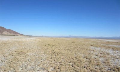
The current potential state exists with a shallow water table that remains within less than one meter of the soil surface, and regular intermittent ponding that dilutes soil surface salinity. Saltgrass monocultures dominate this state, with production and cover varying with ponding, DTW, and soil surface salinity. Invasive species are negligible in this site due to the harsh conditions present.
Submodel
Description
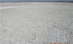
This state is dominated by a barren playa surface with heavy salt accumulations. Unvegetated playa surfaces are more prone to wind erosion, and the resulting dust is a major source of air pollution (e.g. Gill 1996, Lancaster and Baas 1998, Pelletier 2006, Reynolds et al. 2007, Groeneveld and Barz 2013).
Submodel
Description
This state is provisional, and is based on evidence from other playa systems. Declines in groundwater below the capillary zone decreases soil surface salinity, allowing colonization by less salt-tolerant deeper-rooted shrubs such as alkalki goldenbush, cattle saltbush (Atriplex polycarpa), fourwing saltbush (Atriplex canescens), and honey mesquite (Prosopis glandulosa). Further declines in the water table will lead to colonization by upland species such as creosote bush (Larrea tridentata), burrobush (Ambrosia dumosa), and big galleta (Pleuraphis rigida).
Submodel
Mechanism
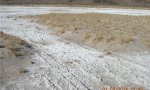
This transition occurs with persistent moderate declines in groundwater, where capillary action still draws water to the soil surface, but shallow surface horizons are dry relative to State 1, causing increased salt concentrations on the surface. Generally groundwater depth below 3 meters does not contribute to salt concentrations on the soil surface (Waisel 1972), although this may vary with horizon textures.
Mechanism
This transition occurs with persistent severe declines in groundwater, where capillary action no longer draws salt to the soil surface (approximately more than 3 meters below the soil surface).
Mechanism
Groundwater is recharged either through reduction in use, following above average precipitation years or both.
Model keys
Briefcase
Add ecological sites and Major Land Resource Areas to your briefcase by clicking on the briefcase (![]() ) icon wherever it occurs. Drag and drop items to reorder. Cookies are used to store briefcase items between browsing sessions. Because of this, the number of items that can be added to your briefcase is limited, and briefcase items added on one device and browser cannot be accessed from another device or browser. Users who do not wish to place cookies on their devices should not use the briefcase tool. Briefcase cookies serve no other purpose than described here and are deleted whenever browsing history is cleared.
) icon wherever it occurs. Drag and drop items to reorder. Cookies are used to store briefcase items between browsing sessions. Because of this, the number of items that can be added to your briefcase is limited, and briefcase items added on one device and browser cannot be accessed from another device or browser. Users who do not wish to place cookies on their devices should not use the briefcase tool. Briefcase cookies serve no other purpose than described here and are deleted whenever browsing history is cleared.
Ecological sites
Major Land Resource Areas
The Ecosystem Dynamics Interpretive Tool is an information system framework developed by the USDA-ARS Jornada Experimental Range, USDA Natural Resources Conservation Service, and New Mexico State University.