Provisional. A provisional ecological site description has undergone quality control and quality assurance review. It contains a working state and transition model and enough information to identify the ecological site.
Areas shown in blue indicate the maximum mapped extent of this ecological site. Other ecological sites likely occur within the highlighted areas. It is also possible for this ecological site to occur outside of highlighted areas if detailed soil survey has not been completed or recently updated.
MLRA notes
Major Land Resource Area (MLRA): 030X–Mojave Basin and Range
MLRA statement:
Major Land Resource Area (MLRA) 30, Mojave Desert, is found in southern California, southern Nevada, the extreme southwest corner of Utah and northwestern Arizona within the Basin and Range Province of the Intermontane Plateaus. The climate of the area is hot (primarily hyperthermic and thermic; however at higher elevations, generally above 5000 feet, mesic, cryic and frigid) and dry (aridic). Elevations range from below sea level to over 12,000 feet in the higher mountain areas found within the MLRA. Due to the extreme elevational range found within this MLRA, land resource units (LRUs) were designated to group the MLRA into similar land units.
LRU notes
"XY" LRU:
This LRU is found throughout the Mojave Desert MLRA. This LRU designation is set aside for ecological sites that are ubiquitous throughout the MLRA. These sites are driven by environmental or chemical features that override the climatic designations of the other LRU’s or are atypical compared to the surrounding landscape. Common overriding XY characteristics within this MLRA include: ephemeral streams subject to flash flood events, riparian areas or other water features, and soils with strong chemical influence (Na, Ca, etc).
Ecological site concept
This ecological site is associated with first and second order drainageways, where flow loses velocity or becomes divergent across inset fans and fan aprons. This site has small active drainageways, with adjacent areas that are prone low intensity sheet floods of less frequency. Creosote bush (Larrea tridentata), Schott’s dalea (Psorothamnus schottii) and burrobush (Ambrosia dumosa) are dominant on this site. It is found at elevations of 1020 to 3280 feet and on 0 to 8 percent slopes.
Data ranges in the physiographic data, climate data, water features, and soil data sections of this Ecological Site Description are based on major and minor components, since it is often only associated with minor components.
This site is part of provisional concept R030XY001CA
This ecological site is on gravelly alluvial fans that experience sheet floods, and a high diversity of species are present including Schott's dalea, creosote bush, desertsenna, Mexican bladdersage and Mojave Yucca.
This site is found on occasionally flooded drainageways, inset fan, and fan aprons. Elevations range from 1020 to 3280 feet, and slopes range from 0 to 8 percent.
Table 2. Representative physiographic features
Landforms
(1) Drainageway (2) Inset fan (3) Fan apron
Flooding duration
Extremely brief (0.1 to 4 hours) to very brief (4 to 48 hours)
Flooding frequency
None to occasional
Elevation
1,020–3,280 ft
Slope
8%
Climatic features
The climate is arid with hot, dry summers and warm, moist winters. The mean annual precipitation is 75 to 125 millimeters (3 to 5 inches) and the mean annual air temperature is 20 to 23 degrees C (68 to 73 degrees F.). The frost-free season is 300 to 340 days, and the freeze-free season is 340 to 360 days.
The tabular climate summary for this ESD was generated by the Climate Summarizer
(http://www.nm.nrcs.usda.gov/technical/handbooks/nrph/Climate_Summarizer.xls) using data from the climate stations listed below (results are unweighted averages).
Table 3. Representative climatic features
Frost-free period (average)
340 days
Freeze-free period (average)
360 days
Precipitation total (average)
5 in
Bar
Line
Figure 2. Monthly precipitation range
Bar
Line
Figure 3. Monthly average minimum and maximum temperature
Influencing water features
This ecological site is influenced by occasional flash flood events, which flood the drainageways and sheet flood across inset fans and alluvial fans.
Soil features
The soils associated with this ecological site are very deep, somewhat excessively to excessively drained, and formed in alluvium from gneiss or granitoid parent material. The surface textures are very gravelly loamy sand and gravelly sand. Subsurface horizons (1 to 59 inches) are composed of sandy textures with non gravelly to extremely gravelly modifiers. The surface rock fragments less than 3 inches range from 0 to 45 percent cover, and fragments greater than 3 inches range from 0 to 35 percent cover. The subsurface percent by volume of rock fragments less than 3 inches ranges from 17 to 65, and greater that 3 inch fragments range from 0 to 5.
The Carrizo soils are: sandy-skeletal, mixed, hyperthermic Typic Torriorthents. The Pintobasin soils are: mixed, hyperthermic Typic Torripsamments.
This ecological site is associated with the following map units and soil components within the Joshua Tree National Park Soil Survey (CA794):
Somewhat excessively drained to excessively drained
Permeability class
Rapid
Soil depth
60 in
Surface fragment cover <=3"
45%
Surface fragment cover >3"
35%
Available water capacity (0-40in)
1–2.8 in
Calcium carbonate equivalent (0-40in)
1%
Electrical conductivity (0-40in)
Not specified
Sodium adsorption ratio (0-40in)
Not specified
Soil reaction (1:1 water) (0-40in)
6–8
Subsurface fragment volume <=3" (Depth not specified)
17–65%
Subsurface fragment volume >3" (Depth not specified)
5%
Ecological dynamics
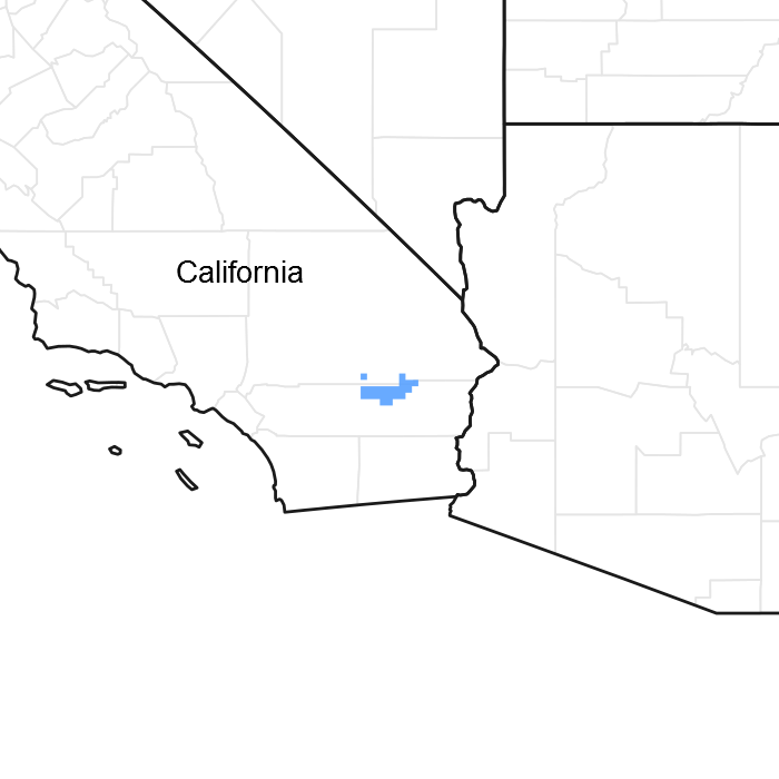
This ecological site occurs at the base of mountains on drainageways, inset fans and fan aprons. This site is distinguished by a small drainage size, on first and second order streams, low sediment transport capacity, and the absence of deep rooted phreatophytes, such as desert willow or catclaw acacia. This site receives flow from first and second order drainageways, but the flow infiltrates into the sandy soils in the divergent channels, leaving the distal areas without surface flow except in extreme precipitation events. Soil disturbance from flash flood events is the primary driver of plant community dynamics within this ecological site. The soils are hyperthermic, very deep, and composed of sands and gravels. Shrub diversity is higher than the surrounding less flooded landforms on the fan piedmont slope. Schott's dahlia, creosote bush and burrobush dominate the site.
Ephemeral streams lack permanent flow except in response to rainfall events (Bull 1997, Levick et al. 2008). These ephemeral streams are characterized by extreme and rapid variations in flooding regime, and a high degree of temporal and spatial variability in hydrologic processes (Bull 1997, Stanley et al. 1997, Levick et al. 2008, Shaw and Cooper 2008). The drought-tolerant vegetation that exists on ephemeral streams and drainageways is referred to as xeroriparian vegetation. It is distinct from the surrounding landforms due to a difference in species composition, size, and production (Johnson et al. 1984, Levick et al. 2008). Xeroriparian vegetation is present because of the increased availability of water and flood disturbances in these drainageways. Deep rooted phreatophytes, that rely primarily rely on a deep water source such as desert willow, smoketree, and catclaw acacia are generally absent. Collectively, the plant communities along the drainageways are considered xeroriparian vegetation, and provide xeroriparian habitat.
This site can experience channel avulsion (defined as the “diversion of the majority of the surface flow to a different channel, with total or partial abandonment of the original channel” [(Field 2001)]). As sediment deposits in the active drainageway the likelihood of channel avulsion increases because of decreased drainageway volume. Cycles of channel avulsion on alluvial fans are an ongoing and a long-term process in the development of alluvial fans, and can occur after any substantial overland flow event when existing channel capacity is rapidly and dramatically exceeded.
The active channels are small, and are composed of bare sand and gravels. In less active areas creosote bush, Schott’s dalea, and burrobush are present. Creosote bush and burrobush are larger and more productive in the wash than in neighboring alluvial fans, without the extra run-on. Creosote bush and burrobush are community dominates on adjacent fan aprons. Schott's dalea depends on flood water for dispersal and seed germination (Vogl and McHargue 1966), and occurs on hyperthermic soils in habitats receiving additional run-on such as rocky hill-slopes, washes, and alluvial fans with regular sheet-flow. This site is at the northern most distribution of Schott’s dalea. It is more common further south in California and Northern Mexico. Data is lacking on the ecology of this species.
Other disturbances such as drought, fire, and human hydrologic alterations can affect the community composition and/or hydrologic process of this site. Drought is common in the desert, and can cause mortality or die-back of vegetation. Decreased vegetative cover can lead to increased erosion and change sediment deposition patterns, possibly increasing the chance of channel migration.
Historically fire was very uncommon in these ephemeral drainages; however the presence of continuous and flashy fuels from non-native grasses in adjacent upland sites can increase the possibility of fire. Invasion by non-native annual grasses has increased the flammability of desert vegetation communities (Brooks 1999 2004), and after fire, Mojave Desert ecosystems appear to be more susceptible to invasion by exotic grasses, leading to a grass-fire cycle (D'Antonio and Vitousek 1992). Very wet (El Nino) years followed by severe drought produce conditions where large areas where creosote scrub burn (Brown and Minnich 1986, DeFalco et al. 2010).
A properly functioning ephemeral drainage will provide some similar hydrologic functions as perennial streams. Ephemeral streams maintain water quality by allowing energy dissipation during high water flow. They transport nutrients and sediments, store sediments and nutrients in deposition zones, provide temporary storage of surface water, and longer duration storage of subsurface water. The structure and forage provided by diverse vegetation, and the availability of water (although brief), significantly increases animal abundance along ephemeral streams relative to upland areas. The open channels provide important migration corridors for wildlife (Levick et al. 2008).
When modifications affect the hydrologic function of this ephemeral stream system, this ecological site has the potential to transition to a hydrologically altered state (State 3). Once this threshold is crossed, it is extremely difficult to repair the hydrologic system.
Modifications to hydrology such as surface flow alterations, ground water depletion, and loss of vegetative cover can have irreversible impacts on hydrologic processes (Nishikawa et al. 2004, Levick et al. 2008). An increase in cover of impermeable surfaces (such as pavement, homes, malls, etc.) reduces the amount of runoff that can infiltrate into the soil creating higher surface runoff and greater peak flows. The runoff is collected in ditches, culverts, and drainage networks, and diverted to the nearest ephemeral stream. In some areas, ephemeral streams are armored to reduce damage to property from flood events. These confined channels reduce the ability for the stream to spread out and decrease flow velocity to allow sediment deposition. As a result, the channels will generally incise, with a higher volume of concentrated flows. These processes eventually cause higher peak flows due to increased runoff and concentrated flows. Higher flow velocities may cause uprooting, stem breakage or scour under the roots of vegetation. This loss of root structure along the stream increases scour potential, and the loss of above ground vegetation will increase flow velocity. When the vegetative community is degraded, important animal species dependent upon this community may be lost from the area as well. Ground water drawdown from household wells (Nishikawa et al. 2004) can deplete the water source for deep rooted species.
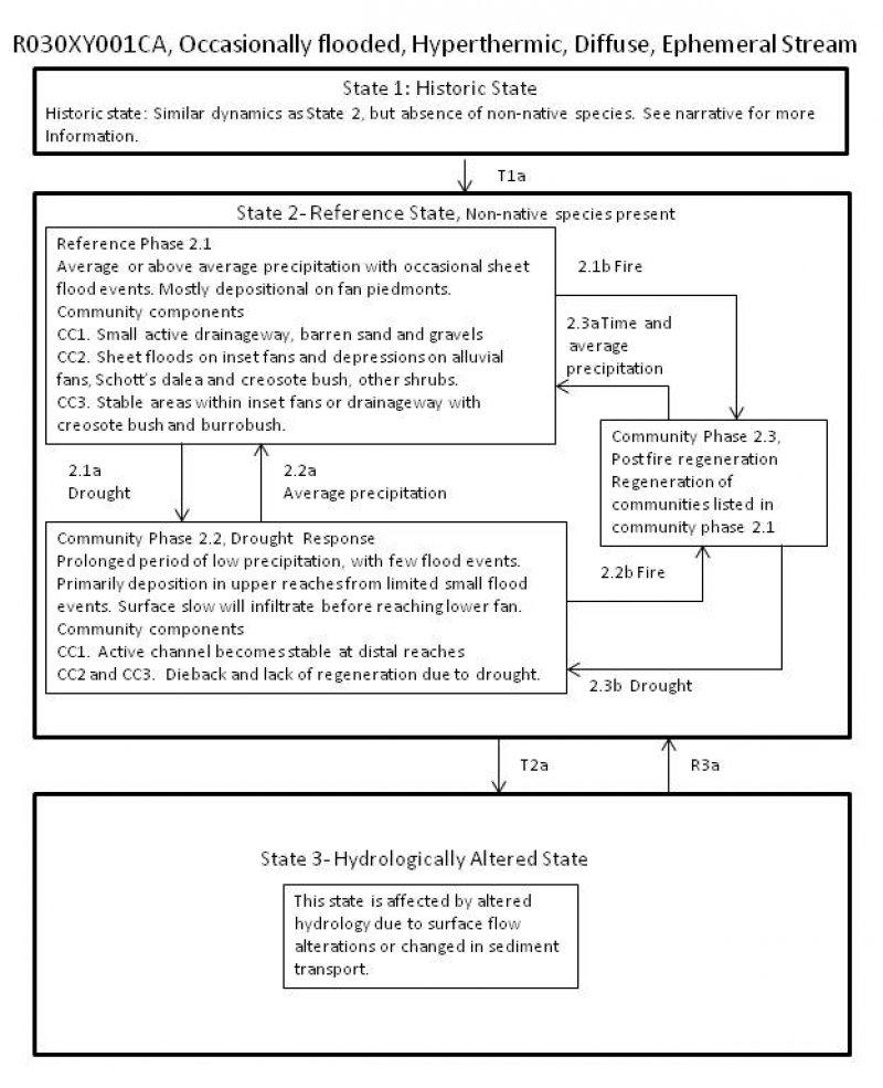
State 1 represents the historic-natural condition for this ecological site. It is similar to State 2, but has only native species. If we were to include dynamics for this state it would be the same as displayed in State 2. The presence of non-native species is minimal in State 2, and has not altered the hydrology or fire frequency.
State 2 Reference State
This state represents the most common and most ecologically intact condition for this ecological site at the present time.
Community 2.1 Reference Phase
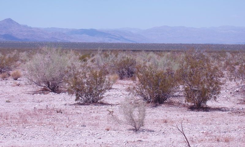
Figure 5. Community Phase 2.1
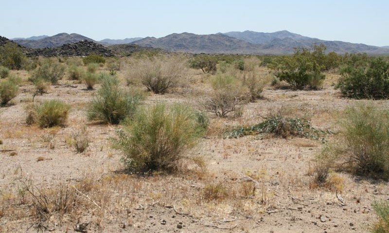
Figure 6. Community Phase 2.1
This community phase is dependent upon unimpaired hydrologic function and average to above average precipitation. At any given point along the stream the following community components are generally present. The relative spatial extent of these communities varies as the channel morphology fluctuates from flash flood events. Areas with sheet flow have a higher area of surface disturbance and will have more disturbance dependent species.
Three community components are present, including:
Community Component 1 (CC1):
Small active drainageway with occasional surface flow.
Community Component 2 (CC2):
This community is present on inset fans and depressions on alluvial fans. Sheet floods provide additional moisture and soil disturbance, which encourage the establishment of Schott's dalea, bladderpod spiderflower (Cleome isomeris), and burrobrush (Hymenoclea salsola). Creosote bush is larger and burrobrush is more abundant on this site than on the adjacent non-flooded alluvial fans. The presence and abundance of annual forbs is dependent upon precipitation but whitemargin sandmat (Chamaesyce albomarginata), cryptantha (Cryptantha sp.), western Mojave buckwheat (Eriogonum mohavense), smooth desertdandelion (Malacothrix glabrata), birdcage evening primrose (Oenothera deltoides), desert Indianwheat ((Plantago ovata), and chia (Salvia columbariae) are usually present in spring.
Community Component 3 (CC3):
This community is a transitional community that resembles adjacent non-flooded alluvial fans. It is not subject to active flooding, but is within the inset fan and is subject to flooding if channel avulsion occurs, and may have been in an active zone in the past. Creosote bush and burrobush dominate, but other species may include, Wiggins’ cholla (Cylindropuntia echinocarpa), branched pencil cholla (Cylindropuntia ramosissima), brittlebush (Encelia farinosa) and brownplume wirelettuce (Stephanomeria pauciflora), The forbs listed in CC2 are likely in this community as well.
The non-native annual forb redstem stork’s bill (Erodium cicutarium), and the non-native annual grasses red brome (Bromus rubens) and Mediterranean grass (Schismus sp.) arepresent in all community components but with low cover.
Figure 7. Annual production by plant type (representative values) or group (midpoint values)
Table 5. Annual production by plant type
Plant type
Low (lb/acre)
Representative value (lb/acre)
High (lb/acre)
Shrub/Vine
40
250
350
Forb
0
10
40
Grass/Grasslike
0
1
5
Total
40
261
395
Community 2.2 Drought Response
This community develops with prolonged or severe drought. It is difficult to determine the exact duration or intensity of drought that will cause this change, but a one to two year severe drought (of approximately 60 percent or less of average annual precipitation) can cause severe mortality in short lived perennials (Bowers 2005, Hereford et al. 2006, Miriti et al. 2007). During drought years, flood events are unlikely. The plant community components remain similar to those described in Community Phase 2.1, but show a decline in overall health, cover and production due to drought. Shorter lived species in CC2 (such as burrobush, burrobrush, and brittlebush) may suffer high mortality while longer lived species (creosote bush and Schott’s dalea) may have severe branch die back.
Community 2.3 Post-fire Regeneration
Initially annuals and short-lived perennials will dominate. Short-lived shrubs capable of quickly colonizing after fire include burrobush, burrobrush, and brittlebrush. These species produce seeds that are easily wind dispersed to the burn after fire. Creosote bush is generally killed by fire, and is slow to re-colonize burned areas due to specific recruitment requirements (Brown and Minnich 1986, Brooks et al. 2007, Steers and Allen 2011).
Pathway 2.1a Community 2.1 to 2.2
This pathway is caused by a prolonged or severe drought.
Pathway 2.1b Community 2.1 to 2.3
This pathway is caused by moderate to severe fire.
Pathway 2.2a Community 2.2 to 2.1
This pathway occurs with the return of average to above average precipitation and associated flood events.
Pathway 2.2b Community 2.2 to 2.3
This pathway occurs as a result of fire. Given low cover of annuals during drought, this pathway is unlikely except in periods immediately following heavy precipitation years.
Pathway 2.3a Community 2.3 to 2.1
This pathway occurs in response to the passing of time with average to above average precipitation and associate flood events.
Pathway 2.3b Community 2.3 to 2.2
This pathway occurs in response to the passing of time with drought conditions and absence of flooding.
State 3 Hydrologically altered
State 3 represents altered hydrological conditions typical of similar watersheds. Data is needed to develop a successional diagram for this state.
Community 3.1 Hydrologically Altered
Alterations in surface flow or changed in sediment transport capacity alter the stream hydrology. Surface flow can either be diverted away from or to an area. The diversion of flow from an area will cause a decline in disturbance dependent species such as Schott’s dalea and burrobrush and subsequent increase of creosote dominated plant communities. Increased flow to an area can cause erosion with channel widening or incision.
Transition T2A State 2 to 3
Triggers that can cause a transition to State 3 include surface flow alterations and prolonged drought.
Any of the community phases from this state can cross the threshold to State 3, but community phase 2.3 and the later stages of 2.2 are especially vulnerable because decreases in vegetation density (and upland vegetation density) leave soils more susceptible to erosion (Bull 1997).
Restoration pathway R3a State 3 to 2
Restoration from State 3 back to State 2 would be an intensive task. Individual site assessments would be required to determine proper restoration methods. Some hydrological modifications are not feasible restored, such as ground water depletion. However, road diversions can be redesigned to allow proper stream alignment and flow. Seeds or plants of appropriate species may need to be reintroduced to the restored channels.
Additional community tables
Table 6. Community 2.1 plant community composition
This site provides shade, food plants, and cover for a variety of animals. The site has complex vertical structure which provides habitat for birds to perch. Creosote bush is a dominant plant in the site whose root-mound provides good burrowing for lizards, ground squirrels, and other small rodents. Cover is necessary for a wide variety of animals as a refuge from predators. The number of large shrubs and high plant cover allow for many suitable hiding places. Some of the animals that use cover as protection include rodents, birds, snakes and lizards. This site provides habitat for the Threatened desert tortoise.
Hydrological functions
Ephemeral drainages provide some similar hydrologic functions as perennial streams. A properly functioning system will maintain water quality by allowing energy dissipation during high water flow. These systems transport nutrients and sediments, and store sediments and nutrients in deposition zones. Ephemeral drainages provide temporary storage of surface water, and longer duration storage of subsurface water (Levick et al. 2008).
Recreational uses
This site provides many opportunities to view wildlife and wildflowers, with open corridors for easier access.
Other information
Creosote bush is an important medicinal plant for Native Americans. It has a very wide range of uses from treatment for consumption, bowl complaints, and menstrual cramps, to induce vomiting, relief for arthritis, rheumatism, aching bones and sprains, congestion and cold, as an antiseptic and disinfectant, dandruff, antispasmodic, to induce urination, gonorrhea, and to cancer treatment. (This list is not exhaustive). http://herb.umd.umich.edu/herb/search.pl?searchstring=Larrea+tridentata.
The followin NRCS plots were used to describe this ecological site:
X-9 (Patty Novack) Type location
72210-01
PF304-Check
Type locality
Location 1: San Bernardino County, CA
UTM zone
N
UTM northing
3755312
UTM easting
609024
General legal description
The type location is in Joshua Tree National Park, in Pintobasin, at the base of Pinto Mountain, about 2.5 miles southwest of the peak.
Other references
Bowers, J. E. 2005. Effects of drought on shrub survival and longevity in the northern Sonoran Desert. Journal of the Torrey Botanical Society 132:421-431.
Brooks, M. L. 1999. Habitat invasibility and dominance by alien annual plants in the western Mojave Desert. Biological Invasions 1:325-337.
Brooks, M. L., T. C. Esque, and T. Duck. 2007. Creosotebush, blackbrush, and interior chaparral shrublands. RMRS-GTR-202.
Brown, D. E. and R. A. Minnich. 1986. Fire and Changes in Creosote Bush Scrub of the Western Sonoran Desert, California. American Midland Naturalist 116:411-422.
Bull, W. B. 1997. Discontinuous ephemeral streams. Geomorphology 19:227-276.
D'Antonio, C. M. and P. M. Vitousek. 1992. Biological invasions by exotic grasses, the grass/fire cycle, and global change. Annual Review of Ecology and Systematics 23:63-87.
DeFalco, L. A., T. C. Esque, S. J. Scoles-Sciulla, and J. Rodgers. 2010. Desert wildfire and severe drought diminish survivorship of the long-lived Joshua tree (Yucca brevifolia; Agavaceae). American Journal of Botany 97:243-250.
Field, J. 2001. Channel avulsion on alluvial fans in southern Arizona. Geomorphology 37:93-104.
Hereford, R., R. H. Webb, and C. I. Longpre. 2006. Precipitation history and ecosystem response to multidecadal precipitation variability in the Mojave Desert region, 1893-2001. Journal of Arid Environments 67:13-34.
Levick, L., J. .Fonseca, D. Goodrich, M. Hernandez, D. Semmens, J. Stromberg, R. Leidy, M. Scianni, D. P. Guertin, M. Tluczek, and W. Kepner. 2008. The ecological and hydrological significance of ephemeral and intermittent streams in the arid and semi-arid American Southwest.
Miriti, M. N., S. Rodriguez-Buritica, S. J. Wright, and H. F. Howe. 2007. Episodic death across species of desert shrubs. Ecology 88:32-36.
Nishikawa, T., J. A. Izbicki, C. L. Stamos, and P. Martin. 2004. Evaluation of geohydrologic framework, recharge estimates, and ground-water flow of the Joshua Tree area, San Bernardino County, California., U.S. Geological Survey.
Shaw, J. R. and D. J. Cooper. 2008. Linkages among watersheds, stream reaches, and riparian vegetation in dryland ephemeral stream networks. Journal of Hydrology 350:
Stanley, E. H., S. G. Fisher, and N. B. Grimm. 1997. Ecosystem expansion and contraction in streams. Bioscience 47:427-439.
Steers, R. J. and E. B. Allen. 2011. Fire effects on perennial vegetation in the western Colorado Desert, USA. Fire Ecology 7:59-74.
Vogl, R. J. and L. T. McHargue. 1966. Vegetation of California palm oases on the San Andreas Fault. Ecology 47:532-540.
Contributors
Marchel Munnecke P. Novak-Echenique
Approval
Kendra Moseley, 10/21/2024
Rangeland health reference sheet
Interpreting Indicators of Rangeland Health is a qualitative assessment protocol used to
determine ecosystem condition based on benchmark characteristics described in the Reference Sheet. A suite of 17 (or
more) indicators are typically considered in an assessment. The ecological site(s) representative of an assessment
location must be known prior to applying the protocol and must be verified based on soils and climate. Current plant
community cannot be used to identify the ecological site.
Author(s)/participant(s)
Contact for lead author
Date
10/22/2024
Approved by
Kendra Moseley
Approval date
Composition (Indicators 10 and 12) based on
Annual Production
Indicators
Number and extent of rills:
Presence of water flow patterns:
Number and height of erosional pedestals or terracettes:
Bare ground from Ecological Site Description or other studies (rock, litter, lichen, moss, plant canopy are
not bare ground):
Number of gullies and erosion associated with gullies:
Extent of wind scoured, blowouts and/or depositional areas:
Amount of litter movement (describe size and distance expected to travel):
Soil surface (top few mm) resistance to erosion (stability values are averages - most sites will show a range
of values):
Soil surface structure and SOM content (include type of structure and A-horizon color and thickness):
Effect of community phase composition (relative proportion of different functional groups) and spatial
distribution on infiltration and runoff:
Presence and thickness of compaction layer (usually none; describe soil profile features which may be
mistaken for compaction on this site):
Functional/Structural Groups (list in order of descending dominance by above-ground annual-production or live foliar
cover using symbols: >>, >, = to indicate much greater than, greater than, and equal to):
Dominant:
Sub-dominant:
Other:
Additional:
Amount of plant mortality and decadence (include which functional groups are expected to show mortality or
decadence):
Average percent litter cover (%) and depth ( in):
Expected annual annual-production (this is TOTAL above-ground annual-production, not just forage annual-production):
Potential invasive (including noxious) species (native and non-native). List species which BOTH characterize
degraded states and have the potential to become a dominant or co-dominant species on the ecological site if
their future establishment and growth is not actively controlled by management interventions. Species that become
dominant for only one to several years (e.g., short-term response to drought or wildfire) are not invasive
plants. Note that unlike other indicators, we are describing what is NOT expected in the reference state for the
ecological site:
The Ecosystem Dynamics Interpretive Tool is an information system framework developed by the USDA-ARS Jornada Experimental Range, USDA Natural Resources Conservation Service, and New Mexico State University.
Click on box and path labels to scroll to the respective text.