Natural Resources
Conservation Service
Ecological site R030XY013NV
SHALLOW SILTY
Last updated: 2/24/2025
Accessed: 04/15/2026
General information
Provisional. A provisional ecological site description has undergone quality control and quality assurance review. It contains a working state and transition model and enough information to identify the ecological site.
Ecological site concept
This site occurs on alluvial flats and lakeplain terraces on all exposures. Slopes range from 0 to 8 percent, but slope gradients of 0 to 4 percent are most typical. Elevations are 2300 to 5300 feet. These are deep, alluvial soils derived from mixed parent material. Soil surface is covered by approximately 30 percent pebbles or pan fragments.
This site is associated with group concept R030XA096NV.
Similar sites
| R030XY040NV |
SODIC TERRACE LYCIU, ATPO and ATCA2 important shrubs |
|---|---|
| R030XB106NV |
GRAVELLY SLOPE 5-7 P.Z. PLRI3 dominant plant; much more productive site |
| R030XB126NV |
GRAVELLY PEDIMENT 5-7 P.Z. PSFR-AMDU2-ATCO codominant shrubs |
| R030XB125NV |
CHANNERY HILL 3-5 P.Z. ATCO-AMDU2 codominant |
| R030XB010NV |
LOAMY SLOPE 5-7 P.Z. More productive site; ATCO-EPNE codominant |
Table 1. Dominant plant species
| Tree |
Not specified |
|---|---|
| Shrub |
(1) Atriplex confertifolia |
| Herbaceous |
Not specified |
Physiographic features
This site occurs on alluvial flats and lakeplain terraces on all exposures. Slopes range from 0 to 8 percent, but slope gradients of 0 to 4 percent are most typical. Elevations are 2300 to 5300 feet.
Table 2. Representative physiographic features
| Landforms |
(1)
Alluvial flat
(2) Lake terrace |
|---|---|
| Flooding duration | Extremely brief (0.1 to 4 hours) to very brief (4 to 48 hours) |
| Flooding frequency | Very rare to rare |
| Ponding frequency | None |
| Elevation | 2,300 – 5,300 ft |
| Slope | 8% |
| Aspect | Aspect is not a significant factor |
Climatic features
The climate associated with this site is hot and arid with warm, moist winters and hot, dry summers. Average annual precipitation is 3 to 7 inches. Mean annual air temperature is 50 to 70 degrees F. The average growing season is about 150 to 250 days.
Table 3. Representative climatic features
| Frost-free period (average) | 250 days |
|---|---|
| Freeze-free period (average) | |
| Precipitation total (average) | 7 in |
Figure 1. Monthly average minimum and maximum temperature
Influencing water features
This site receives additional moisture as run-on from higher landscapes.
Soil features
These are deep, alluvial soils derived from mixed parent material. Soil surface is covered by approximately 30 percent pebbles or pan fragments. Water intake rates are moderately slow, available water holding capacity is high, runoff is very slow to slow and there may be some ponding in depression areas. Soil moisture regime is typic-aridic. Soil series correlated to this site include Vegastorm, a coarse-loamy, carbonatic, thermic Petronodic Haplocalcid, and Pahrump, a loamy-skeletal, carbonatic, thermic Petronodic Haplocalcid.
Table 4. Representative soil features
| Parent material |
(1)
Alluvium
–
limestone
|
|---|---|
| Surface texture |
(1) Gravelly sandy loam (2) Fine sandy loam (3) Silt loam |
| Family particle size |
(1) Loamy |
| Drainage class | Well drained |
| Permeability class | Moderate to moderately rapid |
| Soil depth | 72 – 84 in |
| Surface fragment cover <=3" | 25 – 30% |
| Surface fragment cover >3" | Not specified |
| Available water capacity (0-40in) |
3.9 – 4.7 in |
| Calcium carbonate equivalent (0-40in) |
30 – 60% |
| Electrical conductivity (0-40in) |
16 mmhos/cm |
| Sodium adsorption ratio (0-40in) |
30 |
| Soil reaction (1:1 water) (0-40in) |
8.4 – 9.6 |
| Subsurface fragment volume <=3" (Depth not specified) |
10 – 60% |
| Subsurface fragment volume >3" (Depth not specified) |
Not specified |
Ecological dynamics
The plant communities of this site are dynamic in response to changes in disturbance regimes and weather patterns. Community phase changes are primarily driven by long term drought. Historically, wildfire was infrequent and patchy, due to widely spaced vegetation and low herbaceous production.
Shadscale is a partially deciduous, short lived shrub, and is tolerant of alkaline conditions and relatively high pH. However, germination can be reduced if salt concentrations become too high. Reproduction occurs solely through seed and prolonged drought can result in high mortality of shadscale. Periods of greater than normal precipitation can also lead to increased mortality. Long periods of high soil moisture leave shadscale susceptible to parasites and diseases.
Shadscale and all Atriplex species are well adapted to the Mojave Desert environment. They are examples of extreme drought resistance, surviving more than a week at -6Megapascals of water potential. Tolerance to drought is achieved through the shedding of some leaves, which reduces water loss. The spatial distribution of vegetation of this site impacts runoff, infiltration, sediment redistribution and nutrient cycling. Patches of vegetation increase fine sediment deposition and reduce runoff producing positive feedback dynamics in the plant community. Shrub canopies shield the soil from radiation and rainfall (Puigdefabregas 2005). Shrubs partition the rainfall into interception, throughfall and stem flow. Interception diminishes net rainfall, while stemflow concentrates the water and results in deeper infiltration (Puigdefabregas 2005).
Fire Ecology:
The historic mean fire return interval for shadscale communities ranges from 35 to 100 years. Shadscale communities are usually unaffected by fire because of low fuel loads, although a year of exceptionally heavy winter rains can generate fuels by producing a heavy stand of annual forbs and grasses, increasing fire frequency. Shadscale is generally killed by fire and is fire intolerant. It does not resprout following fire; however, regeneration from onsite seed is common following fire.
Increased presence of non-native annual grasses, such as red brome, can alter fire regimes in shadscale communities by increasing fire frequency under wet to near-normal summer moisture conditions. When fire does occur, the effect on the ecosystem may be extreme. Fire top-kills or kills fourwing saltbush, depending upon ecotype. Fourwing saltbush may sprout after top-kill. Fourwing saltbush probably establishes primarily from seed after fire, with some populations also regenerating vegetatively. Indian ricegrass can be killed by fire, depending on severity and season of burn. Indian ricegrass reestablishes on burned sites through seed dispersed from adjacent unburned areas. Desert needlegrass has persistent dead leaf bases, which make it susceptible to burning. Fire removes the accumulation; a rapid, cool fire will not burn deep into the root crown. Most perennial grasses have root crowns that can survive wildfire.
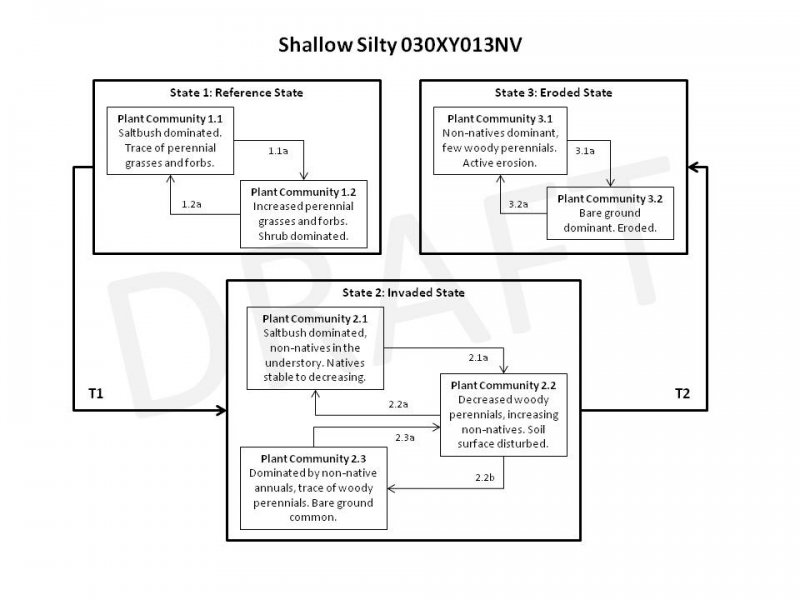
State and transition model
More interactive model formats are also available.
View Interactive Models
More interactive model formats are also available.
View Interactive Models
Click on state and transition labels to scroll to the respective text
Ecosystem states
State 1 submodel, plant communities
State 2 submodel, plant communities
State 3 submodel, plant communities
State 1
Reference State
The reference state is representative of the natural range of variability under pristine conditions. The plant community is shrub dominated with few perennial grasses and forbs. Historically, this state experienced an extended fire return interval due to low fuel loading, resulting in long-lived stable salt-desert shrub plant communities. The communities of this state are sparsely vegetated and soil stability is primarily provided by surface rock fragments and microbiotic soil crust. Plant community phase changes are primarily driven by prolonged drought, infrequent wildfire, disease and insect attack.
Community 1.1
Reference Plant Community
The reference plant community is dominated by shadscale with very little else. The shadscale is robust. Potential vegetative composition is about 5 percent grasses, 5 percent forbs and 90 percent shrubs. Approximate ground cover (basal and crown) is less than 8 percent. Annuals are abundant in years with increased spring time precipitation. Soil surface stability is primarily provided by surface gravels and microbiotic soil crust.
Figure 2. Annual production by plant type (representative values) or group (midpoint values)
Table 5. Annual production by plant type
| Plant type | Low (lb/acre) |
Representative value (lb/acre) |
High (lb/acre) |
|---|---|---|---|
| Shrub/Vine | 45 | 90 | 135 |
| Grass/Grasslike | 3 | 5 | 8 |
| Forb | 2 | 5 | 7 |
| Total | 50 | 100 | 150 |
Community 1.2
Plant Community 1.2
This plant community is characteristic of a post-disturbance plant community. Mature woody vegetation has been reduced, bare ground temporarily increases and there is an initial flush of herbaceous plants. This plant community is identified as at-risk of invasion by non-natives. Non-natives are able to take advantage of increased availability of critical resources following wildfire or other disturbance.
Pathway 1.1a
Community 1.1 to 1.2
Wildfire, prolonged drought, disease and/or insect attack.
Pathway 1.2a
Community 1.2 to 1.1
Absence from disturbance and natural regeneration over time.
State 2
Invaded State
The invaded state is characterized by the presence of non-natives in the understory. An biotic threshold has been crossed with the introduced non-native annuals that cannot easily be removed from the system and have the potential to alter disturbance regimes significantly from their natural range of variation. Introduced annuals such as red brome, schismus and redstem filaree have invaded the reference plant community and have become a dominant component of the herbaceous cover. These non-natives annuals are highly flammable and promote wildfires where fires historically have been infrequent. Plant community phase changes in this state are primarily driven by drought and/or anthropogenic disturbances.
Community 2.1
Invaded Plant Community 2.1
This plant community is characterized by the presence of non-natives in the understory. Compositionally this plant community is similar to the reference plant community, ecological function has been not compromised at this time. However, ecological resilience is reduced by the presence of the non-natives. This plant community may respond differently following a disturbance when compared to non-invaded plant communities. Dominant shrubs persist throughout invasion by non-native annuals, however perennial grasses are at a competitive disadvantage and suffer reduced vigor and reproductive capacity.
Community 2.2
Invaded Plant Community 2.2
This plant community is characterized by reduced perennial vegetation and microbiotic soil crust and increased non-native biomass. Soil surface degradation has lead to decreased aggregate stability and organic mater. Management should focus on reducing disturbance levels and protecting native vegetation to ensure a seed source in the future.
Community 2.3
Invaded Plant Community 2.3
This plant community is characterized by a short disturbance return interval. The soil surface is continually disturbed decreasing stability of the soil surface. Non-native annuals take advantage of the increased availability of resources. The loss of perennial vegetation has lead to decreased infiltration and increased runoff. Feedbacks contributing to the stability of this plant community include loss of functional and structural groups and the density, rate of spread and dominance of non-natives. This plant community is identified as “at risk”. Management should focus on stabilizing soil surface and protecting remaining native vegetation.
Pathway 2.1a
Community 2.1 to 2.2
Anthropogenic disturbance, wildfire, prolonged drought, disease and/or insect attack
Pathway 2.2a
Community 2.2 to 2.1
Absence from disturbance and natural regeneration over time.
Pathway 2.2b
Community 2.2 to 2.3
Frequently reoccurring disturbance. Non-native annuals increase.
Pathway 2.3a
Community 2.3 to 2.2
Absence from disturbance and natural regeneration over time.
State 3
Eroded State
The eroded state is characterized by increased bare ground and reduced soil stabilization. Prolonged soil surface disturbance has caused this site to cross an abiotic and biotic thresholds. Loss of vegetation and soil crust has decreased the stability of the soil. Ecological processes such as nutrient cycling and water storage are severely reduced.
Community 3.1
Eroded Plant Community 3.1
This plant community is characterized by active erosion. The vegetation is dominated by non-native annuals. Soil stability is severely reduced due to lack of perennial vegetation and soil and soil nutrients is easily relocated, even during typical rain and wind events.
Community 3.2
Eroded Plant Community 3.2
This plant community is characterized by a total loss of vegetation and soil crust, bare ground is dominant. Ecological processes have been greatly altered, even truncated in some cases. Loss of soil, reduced infiltration and reduced nutrient cycling preventing the establishment of native perennials.
Pathway 3.1a
Community 3.1 to 3.2
Continued disturbance.
Pathway 3.2a
Community 3.2 to 3.1
Non-native annuals germinate and establish even on a severely eroded site.
Transition T1
State 1 to 2
Introduction of non-natives due to a combination of factors including: 1) surface disturbances, 2) changes in the kinds of animals and their grazing patterns, 3) drought, and 4) changes in fire history.
Transition T2
State 2 to 3
Continued soil surface disturbance, loss of perennial vegetation and soil crust.
Additional community tables
Table 6. Community 1.1 plant community composition
| Group | Common name | Symbol | Scientific name | Annual production (lb/acre) | Foliar cover (%) | |
|---|---|---|---|---|---|---|
|
Grass/Grasslike
|
||||||
| 1 | Primary Perennial Grasses | 2–4 | ||||
| Indian ricegrass | ACHY | Achnatherum hymenoides | 1–2 | – | ||
| desert needlegrass | ACSP12 | Achnatherum speciosum | 1–2 | – | ||
| 2 | Secondary Perennial Grasses | 1–5 | ||||
| squirreltail | ELEL5 | Elymus elymoides | 1–2 | – | ||
| alkali sacaton | SPAI | Sporobolus airoides | 1–2 | – | ||
|
Forb
|
||||||
| 3 | Perennial | 1–5 | ||||
| princesplume | STANL | Stanleya | 1–3 | – | ||
| 4 | Annual | 1–5 | ||||
| pepperweed | LEPID | Lepidium | 1–3 | – | ||
|
Shrub/Vine
|
||||||
| 5 | Primary Shrubs | 81–95 | ||||
| shadscale saltbush | ATCO | Atriplex confertifolia | 80–90 | – | ||
| fourwing saltbush | ATCA2 | Atriplex canescens | 1–5 | – | ||
| 6 | Secondary Shrubs | 2–8 | ||||
| spiny hopsage | GRSP | Grayia spinosa | 1–2 | – | ||
| desert-thorn | LYCIU | Lycium | 1–2 | – | ||
| bud sagebrush | PIDE4 | Picrothamnus desertorum | 1–2 | – | ||
| seepweed | SUAED | Suaeda | 1–2 | – | ||
Interpretations
Animal community
Livestock Interpretations:
This site has limited value for livestock grazing due to low forage production.
Shadscale is a valuable browse species, providing a source of palatable, nutritious forage for a wide variety of livestock. Indian ricegrass is highly palatable to all classes of livestock in both green and cured condition. It supplies a source of green feed before most other native grasses have produced much new growth. Young desert needlegrass is palatable to all classes of livestock. Mature herbage is moderately grazed by horses and cattle, but rarely grazed by sheep. Shadscale provides good browse for domestic sheep. Shadscale leaves and seeds are an important component of domestic sheep and cattle winter diets. Fourwing saltbush is one of the most palatable shrubs in the West. Its protein, fat, and carbohydrate levels are comparable to alfalfa. It provides nutritious forage for all classes of livestock. Palatability is rated as good for domestic sheep and domestic goats; fair for cattle; fair to good for horses in winter, poor for horses in other seasons.
Stocking rates vary over time depending upon season of use, climate variations, site, and previous and current management goals. A safe starting stocking rate is an estimated stocking rate that is fine tuned by the client by adaptive management through the year and from year to year.
Wildlife Interpretations:
Shadscale is a valuable browse species, providing a source of palatable, nutritious forage for a wide variety of wildlife particularly during spring and summer before the hardening of spiny twigs. It supplies browse, seed, and cover for birds, small mammals, rabbits, deer, and pronghorn antelope. Fourwing saltbush provides valuable habitat and year-round browse for wildlife. Fourwing saltbush also provides browse and shelter for small mammals. Additionally, the browse provides a source of water for black-tailed jackrabbits in arid environments. Granivorous birds consume the fruits. Wild ungulates, rodent and lagomorphs readily consume all aboveground portions of the plant. Palatability is rated good for deer, elk, pronghorn and bighorn sheep. Indian ricegrass is eaten by pronghorn in moderate amounts whenever available. A number of heteromyid rodents inhabiting desert rangelands show preference for seed of Indian ricegrass. Indian ricegrass is an important component of jackrabbit diets in spring and summer. Indian ricegrass seed provides food for many species of birds. Doves, for example, eat large amounts of shattered Indian ricegrass seed lying on the ground. Young desert needlegrass is palatable to many species of wildlife. Desert needlegrass produces considerable basal foliage and is good forage while young. Desert bighorn sheep graze desert needlegrass.
Hydrological functions
Runoff is very low to high. Permeability is moderately slow to moderately rapid.
Recreational uses
Aesthetic value is derived from the diverse floral and faunal composition and the colorful flowering of wild flowers and shrubs during the spring and early summer.
Other products
Seeds of shadscale were used by Native Americans of Arizona, Utah and Nevada for bread and mush. Fourwing saltbush is traditionally important to Native Americans. They ground the seeds for flour. The leaves, placed on coals, impart a salty flavor to corn and other roasted food. Top-growth produces a yellow dye. Young leaves and shoots were used to dye wool and other materials. The roots and flowers were ground to soothe insect bites. Indian ricegrass was traditionally eaten by some Native Americans. The Paiutes used the seed as a reserve food source.
Other information
Fourwing saltbush is widely used in rangeland and riparian improvement and reclamation projects, including burned area recovery. It is probably the most widely used shrub for restoration of winter ranges and mined land reclamation.
Supporting information
Type locality
| Location 1: Nye County, NV | |
|---|---|
| Township/Range/Section | T10 S R45 E S14 |
| UTM zone | N |
| UTM northing | 508421 |
| UTM easting | 4102377 |
| Latitude | 37° 4′ 3″ |
| Longitude | 116° 54′ 19″ |
| General legal description | Sarcobatus Valley area, Nye County, Nevada. This site also occurs in Clark County, Nevada. |
Other references
Fire Effects Information System (Online; http://www.fs.fed.us/database/feis/plants/).
Puigdefabregas, J. 2005. The role of vegetation patterns in structuring runoff and sediment fluxes in drylands. Earth Surface Processes and Landforms. 30:133-147.
USDA-NRCS Plants Database (Online; http://www.plants.usda.gov).
Contributors
HA
Approval
Sarah Quistberg, 2/24/2025
Rangeland health reference sheet
Interpreting Indicators of Rangeland Health is a qualitative assessment protocol used to determine ecosystem condition based on benchmark characteristics described in the Reference Sheet. A suite of 17 (or more) indicators are typically considered in an assessment. The ecological site(s) representative of an assessment location must be known prior to applying the protocol and must be verified based on soils and climate. Current plant community cannot be used to identify the ecological site.
| Author(s)/participant(s) | P.Novak-Echenique/E. Hourihan |
|---|---|
| Contact for lead author | State Rangeland Management Specialist |
| Date | 11/17/2011 |
| Approved by | Sarah Quistberg |
| Approval date | |
| Composition (Indicators 10 and 12) based on | Annual Production |
Indicators
-
Number and extent of rills:
None -
Presence of water flow patterns:
Water flow patterns are rare to common dependent on site location relative to major inflow areas. Water flow patterns are typically short, ending in depressional areas where water ponds. -
Number and height of erosional pedestals or terracettes:
None -
Bare ground from Ecological Site Description or other studies (rock, litter, lichen, moss, plant canopy are not bare ground):
Bare Ground ± 80% -
Number of gullies and erosion associated with gullies:
None -
Extent of wind scoured, blowouts and/or depositional areas:
None -
Amount of litter movement (describe size and distance expected to travel):
Fine litter (foliage of grasses and annual & perennial forbs) expected to move distance of slope length during periods of intense summer convection storms. Persistent litter (large woody material) will remain in place except during unusual flooding events. -
Soil surface (top few mm) resistance to erosion (stability values are averages - most sites will show a range of values):
Soil stability values will range from 1 to 4. (To be field tested.) -
Soil surface structure and SOM content (include type of structure and A-horizon color and thickness):
Structure of soil surface will be weak or thick platy. Soil surface colors are pale browns and soils are typified by an ochric epipedon. Organic matter is less than 1.0 percent. -
Effect of community phase composition (relative proportion of different functional groups) and spatial distribution on infiltration and runoff:
Rare flooding and brief ponding may occur during the winter months. Runoff is low. Deep-rooted bunchgrasses (i.e., Indian ricegrass) increase infiltration. -
Presence and thickness of compaction layer (usually none; describe soil profile features which may be mistaken for compaction on this site):
Compacted layers are none. Massive subsurface layers or calcic horizons are normal for this site and are not to be interpreted as compaction. -
Functional/Structural Groups (list in order of descending dominance by above-ground annual-production or live foliar cover using symbols: >>, >, = to indicate much greater than, greater than, and equal to):
Dominant:
salt-desert shrubsSub-dominant:
deep-rooted, cool season, perennial bunchgrasses > associated shrubs > deep-rooted cool, season, perennial forbs > warn season bunchgrasses > deep-rooted, cool season, perennial forbs = fibrous, shallow-rooted, cool season, perennial and annual forbsOther:
Additional:
-
Amount of plant mortality and decadence (include which functional groups are expected to show mortality or decadence):
Dead branches within individual shrubs common and standing dead shrub canopy material may be as much as 30% of total woody canopy -
Average percent litter cover (%) and depth ( in):
Between plant interspaces and under shrubs (5-10%) and depth (± ¼ in.) -
Expected annual annual-production (this is TOTAL above-ground annual-production, not just forage annual-production):
For normal or average growing season (March thru May) ± 100 lbs/ac; Favorable years 150 lbs/ac and unfavorable years 50 lbs/ac. -
Potential invasive (including noxious) species (native and non-native). List species which BOTH characterize degraded states and have the potential to become a dominant or co-dominant species on the ecological site if their future establishment and growth is not actively controlled by management interventions. Species that become dominant for only one to several years (e.g., short-term response to drought or wildfire) are not invasive plants. Note that unlike other indicators, we are describing what is NOT expected in the reference state for the ecological site:
Potential invaders include: red brome, Mediterranean grass, redstem filaree, annual mustards, and Russian thistle. -
Perennial plant reproductive capability:
All functional groups should reproduce in average (or normal) and above average growing season years. Little growth or reproduction occurs during below average years.
Print Options
Sections
Font
Other
The Ecosystem Dynamics Interpretive Tool is an information system framework developed by the USDA-ARS Jornada Experimental Range, USDA Natural Resources Conservation Service, and New Mexico State University.
Click on box and path labels to scroll to the respective text.