Natural Resources
Conservation Service
Ecological site R034AA203UT
Semi-desert Saline Terraces (Gardner's saltbush/ Bluebunch wheatgrass)
Last updated: 9/07/2023
Accessed: 11/23/2024
General information
Provisional. A provisional ecological site description has undergone quality control and quality assurance review. It contains a working state and transition model and enough information to identify the ecological site.
MLRA notes
Major Land Resource Area (MLRA): 034A–Cool Central Desertic Basins and Plateaus
Major Land Resource Area (MLRA) 34A, Cool Central Desertic Basins and Plateaus, consists of approximately 21 million acres in Wyoming, Colorado and Utah, it consists of 11 Land Resource Units (LRU). These units are divisions of the MLRA based on geology, landscape, common soils, water resources and plant community potentials. The elevation spans from approximately 5600 feet (1700 m) along the Green River in UT and CO to approximately 9500 feet (2900m) near Jeffrey City, WY. Annual precipitation ranges from 7 to 16 inches (177 to 406 mm), with the driest areas in the Green River and Great Divide Basins and the wettest areas in northern Carbon County, Southeast Fremont County and Albany County. There is a seasonal weather pattern that trends west to east, with more winter precipitation in the west and more spring/summer in the east, illustrated by diminishing amounts of Big Sagebrush in the eastern part of the MLRA.
LRU notes
The Bear River Valley LRU is located on the far western side of MLRA 34A between the Bear River Divide and the Monte Cristo Range, from Woodruff, Utah at the southern end to Cokeville, Wyoming at the northern end. The total area of the LRU is approximately 340,000 acres. It shares a boundary with MLRA 47, 43B and 46 (proposed).
This LRU differs from the others in its geology, which is comprised mostly of alluvium and colluvium from the Stump Formation. Its weather patterns are such that the soil moisture is xeric, there is a slight peak in winter precipitation in this LRU, with typical yearly precipitation between 9 to 15 inches (230-380 mm). The soil temperature regime of this LRU is frigid with mean annual soil temperatures ranging from 44 to 48 degrees Fahrenheit (6.7 to 8.8°C). The elevation range is from 5700 to 7000 feet (1730 to 2130 m). The soils in the Bear River Valley are dominated by young aged very deep soils developed from sandstone and shale parent material re-worked with recent alluvium. Soils are dominated by Alfisols with young argillic horizons and by Fluvents in more recent alluvium.
The Bear River runs through this LRU, allowing for ample amounts of irrigation water used in the lowland areas to produce hay. Smaller tributaries originating from the neighboring mountains.
Ecological site concept
• This site does not receive any additional water.
• These soils:
o saline or saline-sodic
o are moderately deep, deep, or very deep
o are not skeletal within 20” of the soil surface; and have minimal rock fragments at the soil surface
o are not strongly or violently effervescent in the surface mineral layer (within top 10”)
o have surface textures that usually range from fine sandy loam to clay loam in surface mineral layer (4”)
• have slopes less than 30 percent
• clay content is not greater than 35% in mineral soil surface layer (1-2”)
Associated sites
| R034AA201UT |
Semi-desert Saline Well-Drained Terraces (Indian ricegrass/ Greasewood) |
|---|
Similar sites
| R034AA201UT |
Semi-desert Saline Well-Drained Terraces (Indian ricegrass/ Greasewood) |
|---|
Table 1. Dominant plant species
| Tree |
Not specified |
|---|---|
| Shrub |
(1) Atriplex gardneri |
| Herbaceous |
(1) Pseudoroegneria spicata |
Click on box and path labels to scroll to the respective text.
Ecosystem states
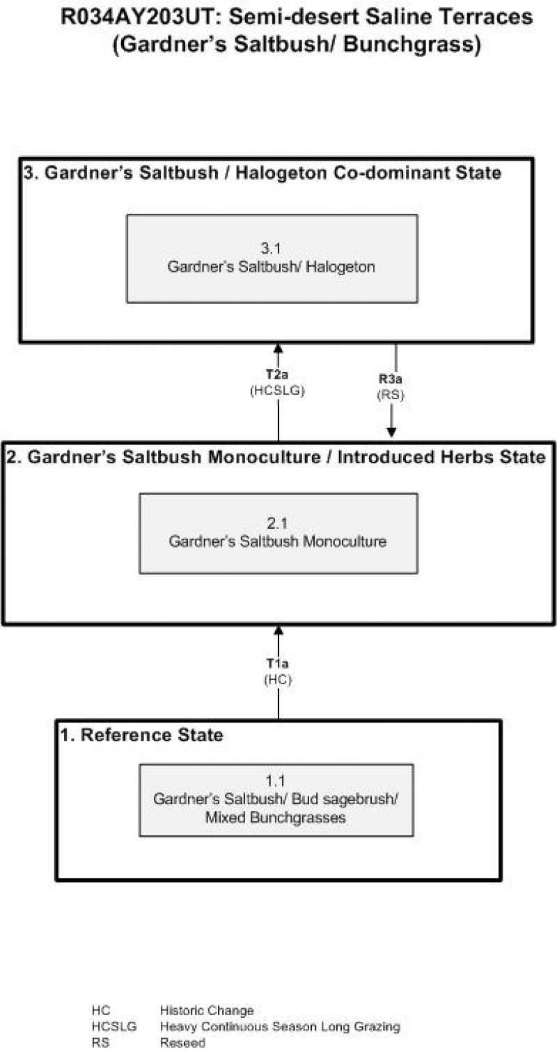
| T1A | - | The simultaneous introduction of exotic species, both plants and animals, and possible extinctions of native flora and fauna, along with year long heavy livestock grazing and climate change |
|---|---|---|
| T2A | - | Trigger causing transition: sustained heavy grazing especially during the growing season Restoration pathway: not apparent at this time. |
| R3A | - | Reseeding with tall wheatgrass |
