Ecological dynamics
State 1
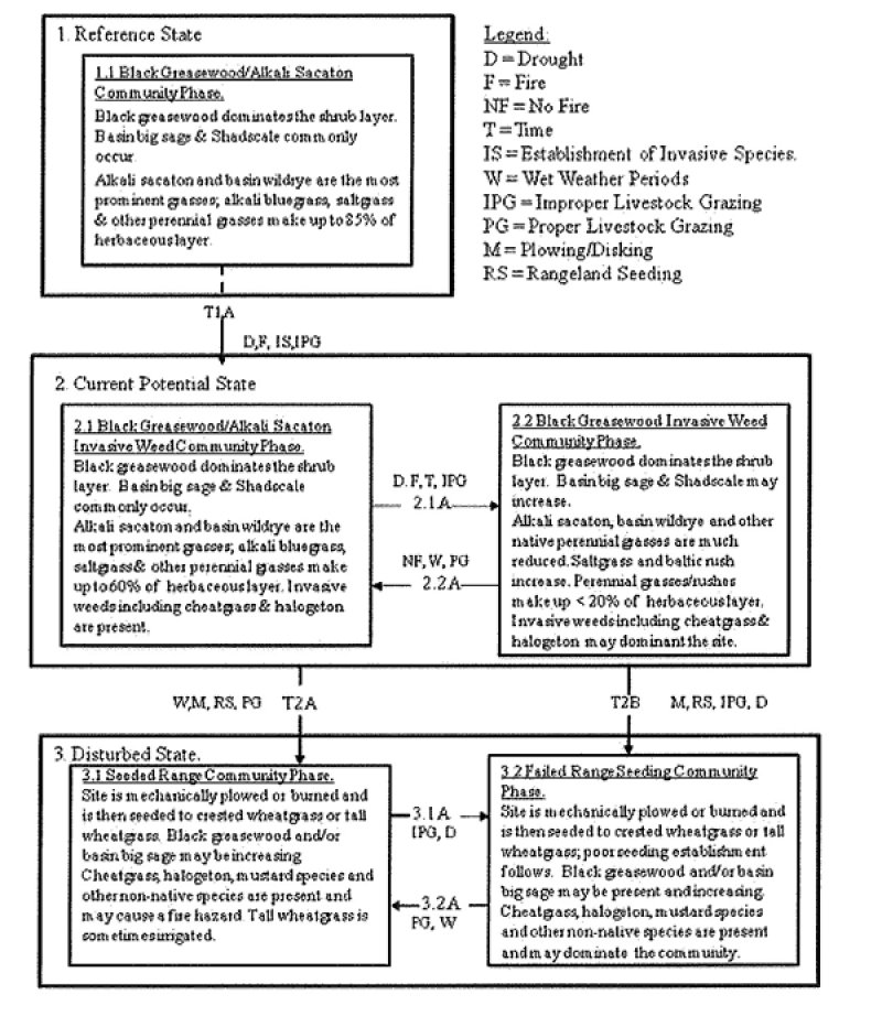
Reference State
This state includes the biotic communities that become established on the ecological site if all successional sequences are completed under the natural disturbance regime. The reference state is generally dominated by black greasewood and alkali sacaton. The reference state is self sustaining and resistant to change due to high resistance to natural disturbances and high resilience following natural disturbances. When natural disturbances occur, the rate of recovery is variable due to disturbance intensity. Once invasive plants establish, return to the reference state may not be possible.
Reference State: Black greasewood/alkali sacaton state with natural fluctuations that form either a shrubland or grassland aspect depending on the natural disturbance history.
Indicators: A community dominated by greasewood and and alkali sacaton.
Feedbacks: Improper livestock grazing of perennial grasses and/or other disturbances that may allow for the establishment of invasive species.
At-risk Community Phase: This state is at risk when native plants are stressed and nutrients become available for invasive plants to establish.
Trigger: The establishment of invasive plant species.
Community 1.1
Black greasewood/Alkali Sacaton Community Phase.
This community is characterized by an open black greasewood shrub canopy, small amounts of basin big sagebrush and shadscale may also present. The site however, has a grassland aspect with alkali sacaton, alkali bluegrass and basin wildrye dominating the herbaceous layer. Other perennial grasses, shrubs, and forbs are also present. The composition by air-dry weight is approximately 85 percent perennial grasses, 5 percent forbs, and 10 percent shrubs. Bare ground is variable (20-40%) depending on the amount of biological crust (0 to 15), and plant cover.
State 2
Current Potential State
The current potential state is similar to the reference state, however invasive grasses and/ or forbs are now present in all community phases. This state is still dominated by an open canopy of black greasewood, however depending on disturbance history, basin big sagebrush and rubber rabbitbrush may be prominent on the site. Alkali sacaton and basin wildrye are still the primary perennial grass species however, saltgrass, cheatgrass and other less palatable species make up a larger portion of the herbaceous layer.
Primary disturbance mechanisms include native herbivore grazing and proper domestic livestock grazing. Timing of these disturbances dictates the ecological dynamics that occur. The current potential state is still self sustaining; but is losing resistance to change due to lower resilience following disturbances. When disturbances occur, the rate of recovery is variable depending on severity.
Current Potential State: Black greasewood/ alkali sacaton state with variations within a basin big sagebrush and/or rubber rabbitbrush shrubland community. Invasive plants are present.
Indicators: A community dominated by greasewood and/or rubber rabbitbrush where native perennial grasses and forbs are also present. Invasive grasses and/or forbs are present.
Feedbacks: Frequent disturbances that may allow the dominance of annual invasive species such as cheatgrass to dominate.
At-risk Community Phase: As increased disturbance frequency allows for the dominance of annual grasses, such as cheatgrass, this community is at greater risk.
Trigger: Reoccurring disturbance that results in a dominance of annual grasses in the herbaceous layer.
Community 2.1
Black greasewood, Alkali Sacaton, Invasive Weed Community Phase.
This community phase is characterized by a black greasewood shrub canopy with alkali sacaton, alkali bluegrass and basin wildrye still dominating the herbaceous layer. Non-native species including cheatgrass, mustard species, and halogeton are present. The composition by air-dry weight is approximately 60 percent perennial grasses, 10 percent forbs, and 30 percent shrubs. Bare ground is variable (20-50%) depending on the amount of biological crust (0 to 15), and plant cover.
Community 2.2
Black greasewood, Invasive Weed Community Phase.
This community phase is characterized by a black greasewood and/or basin big sagebrush shrub canopy. Alkali sacaton, alkali bluegrass and basin wildrye are much reduced in the understory. Non-native species including cheatgrass, mustard species, alyssum, fivehorn smotherweed and halogeton often dominate the site. Other commonly occurring grasses and grasslikes include saltgrass, baltic rush may be increasing and preferred spacies are decreasing. The composition by air-dry weight is approximately <20 percent perennial grasses, 30 percent forbs, and 50 percent shrubs. Bare ground is variable (20-60%) depending on the amount of biological crusts (0 to 5), and plant cover.
Pathway 2.1A
Community 2.1 to 2.2
This pathway occurs when events favor a decrease in palatable perennial grasses and grasslikes and an increase in less palatable species such as saltgrass and baltic rush. Non-native annuals including cheatgrass and fivehorned smotherweed may eventually dominate the community. Events may include extended drought, improper livestock grazing, and fire that it increase annuals and decrease desirable perennials.
Pathway 2.2A
Community 2.2 to 2.1
This pathway occurs when events favor an increase in palatable perennial grasses and grasslikes an decrease in less palatable species such as saltgrass and baltic rush. Non-native annuals, including cheatgrass and fivehorned smotherweed become less dominate in the community. Events may include extended periods with above average moisture, carefully managed livestock grazing, and the absence of fire, which, in combination, can decrease annuals and less palatable perennials and increase more desirable perennial vegetation.
State 3
Disturbed State
This state occurs when the site is plowed or disked and planted to various rangeland grasses. Tall wheatgrass, crested wheatgrass and Russian wildrye are the most commonly seeded species. These seedings may be very clean and healthy or may have various amounts of non-native annuals including, but are not limited to Russian thistle, cheatgrass, tansy mustard, broom snakeweed, alyssum, 5-horned smotherweed and annual Cryptantha.
Invasive Forb State: Range seeding community phases influenced by livestock grazing practices and weather cycles.
Indicators: Perennial rangeland seeding with annual, invasive forbs and grasses present in various amounts.
Feedbacks: Livestock grazing practices and weather cycles that maintain or degrade the range seeding and suppress or increase the non-native annuals present in the community.
Trigger: The increased establishment of cheatgrass and other annuals that may increase the sites fire interval, decrease perennial seeding production and increase bare ground.
Community 3.1
Seeded Range Community Phase.
This community phase has been mechanically plowed, disked or burned and then seeded to rangeland grasses including crested wheatgrass, tall wheatgrass and/or Russian wildrye. Black greasewood, rubber rabbitbrush and/or basin big sage may be present in small amounts. Annuals iincluding cheatgrass, halogeton, various mustard species and other non-native species are also present in small amounts and during above average moisture years, may become prominent enough in the stand to cause a fire hazard. Tall wheatgrass is sometimes irrigated.
Community 3.2
Failed Range Seeding Community Phase.
This community phase has been mechanically plowed, disked or burned and then seeded to renge seeding species including crested wheatgrass, tall wheatgrass, and/or Russian wildrye. Poor management and/or drought causes the seeding to fail. Black greasewood, rubber rabbitbrush and/or basin big sage may be present and increasing in the stand. Cheatgrass, halogeton, various mustard species and other non-native species are present and often dominate the community.
Pathway 3.1A
Community 3.1 to 3.2
This pathway occurs when events favor an decrease in seeded rangeland species and an increase in unwanted invasive annuals. Events may include extended drought and improper livestock grazing that it increases annuals and decreases desirable perennials.
Pathway 3.2A
Community 3.2 to 3.1
This pathway occurs when events favor an increase in seeded rangeland species and a reduction in unwanted invasive annuals. Events may include a series of above average moisture years and proper livestock grazing.
Transition T1A
State 1 to 2
This transition is from the native perennial warm and cool season grass and grasslike understory in the reference state to a state that contains non-native, invasive species. Events may include the establishment of invasive grasses and forbs, and an increase in black greasewood, basin big sagebrush and/or rubber rabbitbrush. Factors that drive such events include, improper livestock grazing of perennial grasses, prolonged drought, and the presence of a seed source for invasive species. Fire may also be a driver for this change in some instances. Invasive species such as cheatgrass however have been known to invade intact perennial plant communities with little to no disturbance. Once invasive species are found in the plant community a threshold has been crossed.
Transition T2A
State 2 to 3
This transition is from the current potential state to a well established seeded rangeland community phase. Site is plowed, disked and/or burned, and seeded to adapted rangeland species including tall wheatgrass, crested wheatgrass or Russian wildrye. Factors that drive such events include, proper livestock grazing of perennial grasses, sufficient moisture for seeding establishment, and adequate control of unwanted invasive species.
Transition T2B
State 2 to 3
This transition is from the current potential state to a failed seeded rangeland community phase. Site is plowed, disked and/or burned, and seeded to adapted rangeland species including tall wheatgrass, crested wheatgrass or Russian wildrye. Factors that drive such events include, improper livestock grazing of perennial grasses, prolonged drought for seeding establishment, and poor control of unwanted invasive species.
Community 1.1
Reference State
The dominant aspect of this plant community is greasewood and alkali sacaton. The composition by air-dry weight is approximately 75 percent perennial grasses, 5 percent forbs, and 20 percent shrubs.
Table 5. Annual production by plant type
| Plant type |
Low
(lb/acre) |
Representative value
(lb/acre) |
High
(lb/acre) |
| Grass/Grasslike |
713 |
1298 |
1838 |
| Shrub/Vine |
190 |
346 |
490 |
| Forb |
48 |
87 |
123 |
| Total |
951 |
1731 |
2451 |
Table 6. Ground cover
| Tree foliar cover |
0%
|
| Shrub/vine/liana foliar cover |
9-11%
|
| Grass/grasslike foliar cover |
59-61%
|
| Forb foliar cover |
4-6%
|
| Non-vascular plants |
0%
|
| Biological crusts |
0%
|
| Litter |
0%
|
| Surface fragments >0.25" and <=3" |
0%
|
| Surface fragments >3" |
0%
|
| Bedrock |
0%
|
| Water |
0%
|
| Bare ground |
0%
|
Table 7. Canopy structure (% cover)
| Height Above Ground (ft) |
Tree |
Shrub/Vine |
Grass/
Grasslike |
Forb |
| <0.5 |
– |
– |
– |
– |
| >0.5 <= 1 |
– |
– |
– |
4-6% |
| >1 <= 2 |
– |
– |
59-61% |
– |
| >2 <= 4.5 |
– |
9-11% |
– |
– |
| >4.5 <= 13 |
– |
– |
– |
– |
| >13 <= 40 |
– |
– |
– |
– |
| >40 <= 80 |
– |
– |
– |
– |
| >80 <= 120 |
– |
– |
– |
– |
| >120 |
– |
– |
– |
– |