Major Land Resource Area 034B
Warm Central Desertic Basins and Plateaus
Accessed: 04/06/2026
Description
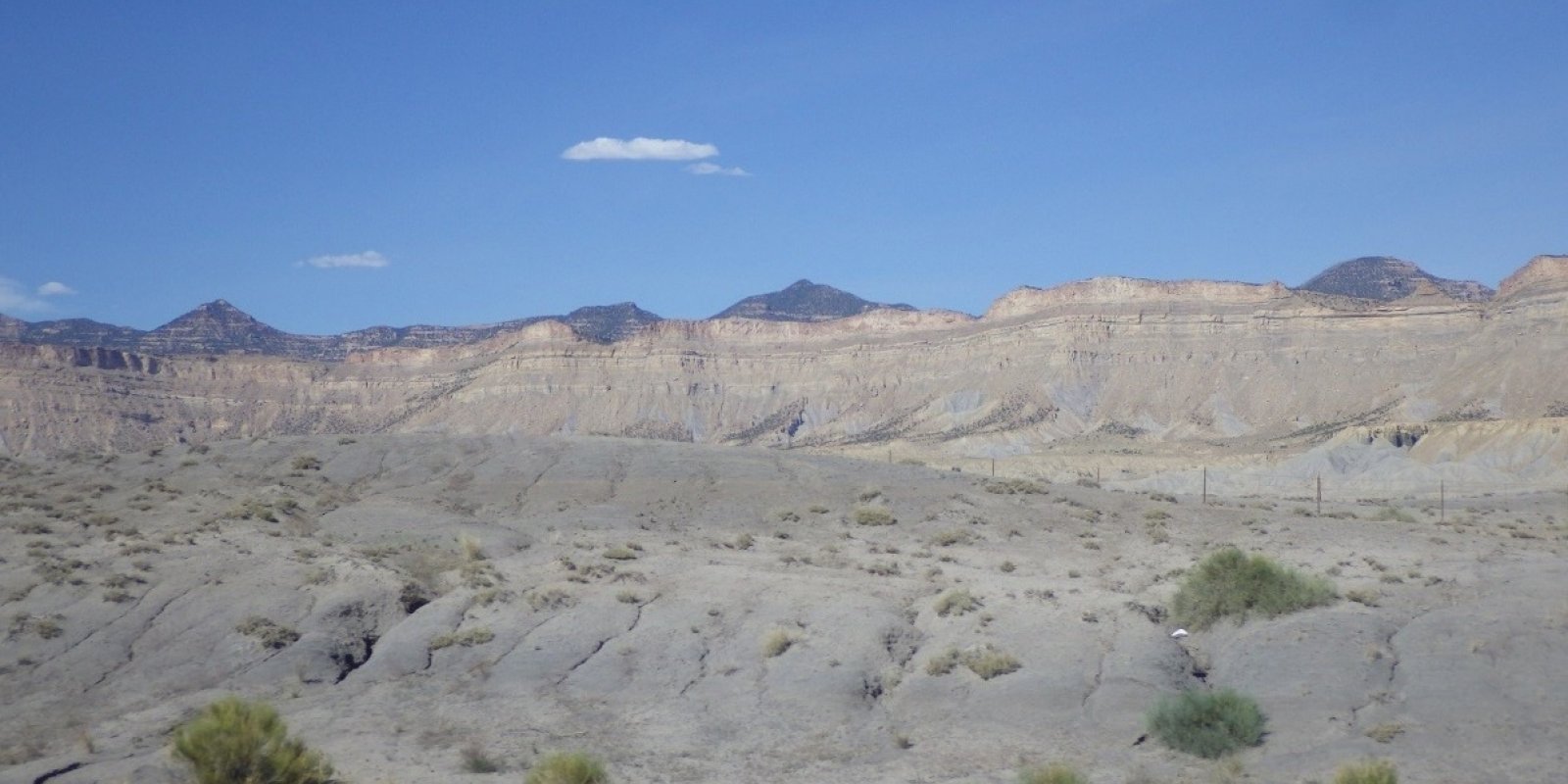
MLRA 34B occurs in is in Utah (70 percent) and Colorado (30 percent). It makes up about 12,850 square miles (33,290 square kilometers). A small part of the area is in the High Plateaus of Utah Section of the Colorado Plateaus Province of the Intermontane Plateaus. The northern part of the MLRA occurs in the Uinta Basin Section, which is bounded by the Uinta Mountains to the north, the Wasatch Range to the west, the Roan Plateau to the south, and the Rabbit Hills to the east. The southern part of the MLRA occurs in the northern third of the Canyon Lands Section. This section is bounded by the Roan Plateau to the north, the Wasatch Plateau to the west, the southern end of the San Rafael Swell to the south, and the western slope of the Rocky Mountains to the east. Elevation ranges from 4,100 feet (1,250 meters) near Green River, Utah, to 7,500 feet (2,285 meters) at the base of the Wasatch Range and the Roan Plateau. Most of this area is covered by residual basin-floor materials and materials washed in from the surrounding mountains and plateaus. Shale and sandstone are the dominant rock types. The Tertiary-age Green River, Uinta, and Duchesne Formations dominate the northern part of the MLRA. The southern part is dominated by Cretaceous-age materials with lesser amounts of Jurassic and Triassic materials. The dominant Cretaceous formations are Mancos Shale, Dakota Sandstone, and the members of the Mesa Verde Group. The dominant Jurassic formations are the Morrison, Entrada, and Navajo. The dominant Triassic formations are the Chinle and Moenkopi. Quaternary alluvial, eolian, and glacial deposits occur in both parts of the MLRA. The average annual precipitation in most of this area ranges from 6 to 10 inches (150 to 255 millimeters). A small part of this area receives as much as 24 inches of annual precipitation. Much of the precipitation occurs as high-intensity, convective thunderstorms during the period July through September. May and June are usually the drier months. Precipitation is more evenly distributed throughout the year in the northern part of the MLRA than in the southern part, where there is a significant peak in late summer. The northern part of the MLRA receives more precipitation as snow during winter than the southern part. The average annual temperature ranges from 41 to 54 degrees F (5 to 12 degrees C). The freeze-free period averages 170 days and ranges from 110 to 235 days. The dominant soil orders in this MLRA are Aridisols and Entisols. Mollisols occur at the higher elevations, particularly in the northern part of the MLRA. The dominant soil temperature regime is mesic, and the dominant soil moisture regime is aridic. The soils receiving less than 8 inches (205 millimeters) of precipitation annually have an aridic soil moisture regime. The soils receiving 8 to 12 inches (205 to 305 millimeters) have an aridic soil moisture regime that borders on ustic. The soils receiving 12 to 16 inches (305 to 405 millimeters) generally have an ustic soil moisture regime that borders on aridic. The dominant soil mineralogy is mixed and soils are formed in slope alluvium or residuum derived from shale or sandstone. Many of the soils are shallow or moderately deep to shale or sandstone bedrock. The soils at the lower elevations generally have significant amounts of calcium carbonate, salts, and gypsum.
Key publications
Next steps
-
1
Select an ecological site
Select an ecological site using the list, keys, photos, briefcase, or quick search option located on this page. -
2
Explore the ecological site description
Next, learn more about the selected ecological site and its characteristic dynamics by browsing the ecological site description and exploring alternative state and transition model formats.
Ecological site list
-
i
Key Characteristics
- Site receives extra water beyond normal precipitation through high water table, riparian area, or run-in water.
- Run-in or Additional Moisture Zone.
- Site occurs in a meadow, fan or flat.
- Site is influenced by salt (alkali).
- Water table is less than 40" from the soil surface for part of the year.
- Water table is between 20 and 40" from the soil surface.
-
i
Key Characteristics
- Site receives extra water beyond normal precipitation through high water table, riparian area, or run-in water.
- Run-in or Additional Moisture Zone.
- Site occurs in a meadow, fan or flat.
- Site is influenced by salt (alkali).
- Water table is deeper than 40" below the soil surface year round.
- Site occurs on a fan.
-
i
Key Characteristics
- Site receives extra water beyond normal precipitation through high water table, riparian area, or run-in water.
- Run-in or Additional Moisture Zone.
- Site occurs in a meadow, fan or flat.
- Site is influenced by salt (alkali).
- Water table is deeper than 40" below the soil surface year round.
- Site occurs on a flat.
-
i
Key Characteristics
- Site receives extra water beyond normal precipitation through high water table, riparian area, or run-in water.
- Run-in or Additional Moisture Zone.
- Site occurs in a meadow, fan or flat.
- Site not influenced by salt.
- Water table is greater than 30" from the soil surface year around.
- Surface soil texture is loamy.
-
i
Key Characteristics
- Site receives extra water beyond normal precipitation through high water table, riparian area, or run-in water.
- Run-in or Additional Moisture Zone.
- Site occurs adjacent to a stream (streambank, floodplain or terrace).
- Water table is greater than 20" from the soil surface year round or March through July.
- Water table is less than 40" from the soil surface year round.
- Fremont cottonwood is the dominant tree.
- Site occurs on floodplains in wider valleys.
-
i
Key Characteristics
- Site receives extra water beyond normal precipitation through high water table, riparian area, or run-in water.
- Run-in or Additional Moisture Zone.
- Site occurs in a meadow, fan or flat.
- Site not influenced by salt.
- Water table is greater than 30" from the soil surface year around.
- Surface soil texture is sandy.
-
i
Key Characteristics
- Site receives extra water beyond normal precipitation through high water table, riparian area, or run-in water.
- Run-in or Additional Moisture Zone.
- Site occurs adjacent to a stream (streambank, floodplain or terrace).
- Water table is greater than 20" from the soil surface year round or March through July.
- Water table is greater than 40" from the soil surface year round.
-
i
Key Characteristics
- Site receives extra water beyond normal precipitation through high water table, riparian area, or run-in water.
- Run-in or Additional Moisture Zone.
- Site occurs in a meadow, fan or flat.
- Site not influenced by salt.
- Water table is less than 30" from the soil surface April-July.
-
i
Key Characteristics
- Site receives extra water beyond normal precipitation through high water table, riparian area, or run-in water.
- Run-in or Additional Moisture Zone.
- Site occurs adjacent to a stream (streambank, floodplain or terrace).
- Water table is greater than 20" from the soil surface year round or March through July.
- Water table is less than 40" from the soil surface year round.
- Fremont cottonwood is the dominant tree.
- Site occurs on streambanks in narrower valleys.
-
i
Key Characteristics
- Site receives extra water beyond normal precipitation through high water table, riparian area, or run-in water.
- Run-in or Additional Moisture Zone.
- Site occurs adjacent to a stream (streambank, floodplain or terrace).
- Water table is greater than 20" from the soil surface year round or March through July.
- Water table is less than 40" from the soil surface year round.
- Narrowleaf cottonwood is the dominant tree.
-
i
Key Characteristics
- Site receives extra water beyond normal precipitation through high water table, riparian area, or run-in water.
- Run-in or Additional Moisture Zone.
- Site occurs adjacent to a stream (streambank, floodplain or terrace).
- Water table is less than 20" from the soil surface year round.
- Water not saline.
-
i
Key Characteristics
- Site receives extra water beyond normal precipitation through high water table, riparian area, or run-in water.
- Run-in or Additional Moisture Zone.
- Site occurs in a meadow, fan or flat.
- Site is influenced by salt (alkali).
- Water table is less than 40" from the soil surface for part of the year.
- Water table is between 0 and 20" from the soil surface year round.
-
i
Key Characteristics
- Site receives extra water beyond normal precipitation through high water table, riparian area, or run-in water.
- Run-in or Additional Moisture Zone.
- Site occurs adjacent to a stream (streambank, floodplain or terrace).
- Water table is less than 20" from the soil surface year round.
- Water saline.
-
i
Key Characteristics
- Site receives no extra water beyond normal precipitation.
- Less than 12" annual precipitation.
- Site receives 4-8" annual precipitation, generally dominated by salt desert shrub communities.
- Desert Ecological Zone.
- Restrictive layer not present within 60" of the soil surface.
- Surface soil very slightly saline to strongly saline (2-16 mmhos/cm EC).
- Soil not as above, but has salt influence.
- Soil not as above.
- Soil is strongly saline.
-
i
Key Characteristics
- Site receives no extra water beyond normal precipitation.
- Less than 12" annual precipitation.
- Site receives 4-8" annual precipitation, generally dominated by salt desert shrub communities.
- Desert Ecological Zone.
- Restrictive layer present within 60" of the soil surface, soil is shallow to moderately deep.
- Restrictive layer 20-60" below the soil surface, soil moderately deep.
- Surface soil texture sandy, site alkaline.
-
i
Key Characteristics
- Site receives no extra water beyond normal precipitation.
- Less than 12" annual precipitation.
- Site receives 4-8" annual precipitation, generally dominated by salt desert shrub communities.
- Desert Ecological Zone.
- Restrictive layer present within 60" of the soil surface, soil is shallow to moderately deep.
- Restrictive layer 5-20" below the soil surface.
- Soil does not have an obvious gypsum component.
- Surface soil texture is loamy clay or clay.
- Soil is moderately saline (surface soil 8-16 mmhos/cm EC).
- Soil is generally moderately deep, but can be shallow, dominant shrub is Castlevalley saltbrush.
-
i
Key Characteristics
- Site receives no extra water beyond normal precipitation.
- Less than 12" annual precipitation.
- Site receives 4-8" annual precipitation, generally dominated by salt desert shrub communities.
- Desert Ecological Zone.
- Restrictive layer present within 60" of the soil surface, soil is shallow to moderately deep.
- Restrictive layer 20-60" below the soil surface, soil moderately deep.
- Surface soil texture is loam to clay, site may or may not be influenced by salts.
- Surface soil texture is clay.
- Soil is generally non saline to slightly saline (0-8 mmhos/cm EC).
-
i
Key Characteristics
- Site receives no extra water beyond normal precipitation.
- Less than 12" annual precipitation.
- Site receives 4-8" annual precipitation, generally dominated by salt desert shrub communities.
- Desert Ecological Zone.
- Restrictive layer not present within 60" of the soil surface.
- Surface soil very slightly saline to strongly saline (2-16 mmhos/cm EC).
- Soil not as above, but has salt influence.
- Soil has obvious gypsum component.
-
i
Key Characteristics
- Site receives no extra water beyond normal precipitation.
- Less than 12" annual precipitation.
- Site receives 4-8" annual precipitation, generally dominated by salt desert shrub communities.
- Desert Ecological Zone.
- Restrictive layer not present within 60" of the soil surface.
- Surface soil non-saline (0-2 mmhos/cm EC).
- Surface soil is loamy.
-
i
Key Characteristics
- Site receives no extra water beyond normal precipitation.
- Less than 12" annual precipitation.
- Site receives 4-8" annual precipitation, generally dominated by salt desert shrub communities.
- Desert Ecological Zone.
- Restrictive layer present within 60" of the soil surface, soil is shallow to moderately deep.
- Restrictive layer 5-20" below the soil surface.
- Soil does not have an obvious gypsum component.
- Surface soil texture is loamy clay or clay.
- Soil is non saline to slightly saline (surface soil 0-8 mmhos/cm EC).
-
i
Key Characteristics
- Site receives no extra water beyond normal precipitation.
- Less than 12" annual precipitation.
- Site receives 4-8" annual precipitation, generally dominated by salt desert shrub communities.
- Desert Ecological Zone.
- Restrictive layer not present within 60" of the soil surface.
- Surface soil non-saline (0-2 mmhos/cm EC).
- Surface soil is sandy.
- Dominant plant is fourwing saltbrush.
-
i
Key Characteristics
- Site receives no extra water beyond normal precipitation.
- Less than 12" annual precipitation.
- Site receives 4-8" annual precipitation, generally dominated by salt desert shrub communities.
- Desert Ecological Zone.
- Restrictive layer not present within 60" of the soil surface.
- Surface soil non-saline (0-2 mmhos/cm EC).
- Surface soil is sandy.
- Dominant plant is Indian ricegrass.
-
i
Key Characteristics
- Site receives no extra water beyond normal precipitation.
- Less than 12" annual precipitation.
- Site receives 4-8" annual precipitation, generally dominated by salt desert shrub communities.
- Desert Ecological Zone.
- Restrictive layer present within 60" of the soil surface, soil is shallow to moderately deep.
- Restrictive layer 5-20" below the soil surface.
- Soil has an obvious gypsum component.
-
i
Key Characteristics
- Site receives no extra water beyond normal precipitation.
- Less than 12" annual precipitation.
- Site receives 4-8" annual precipitation, generally dominated by salt desert shrub communities.
- Desert Ecological Zone.
- Restrictive layer present within 60" of the soil surface, soil is shallow to moderately deep.
- Restrictive layer 5-20" below the soil surface.
- Soil does not have an obvious gypsum component.
- Surface soil texture is loamy clay or clay.
- Soil is moderately saline (surface soil 8-16 mmhos/cm EC).
- Soil generally shallow, restrictive layer less than 20" from the soil surface, dominant plant is mat saltbrush.
-
i
Key Characteristics
- Site receives no extra water beyond normal precipitation.
- Less than 12" annual precipitation.
- Site receives 4-8" annual precipitation, generally dominated by salt desert shrub communities.
- Desert Ecological Zone.
- Restrictive layer present within 60" of the soil surface, soil is shallow to moderately deep.
- Restrictive layer 5-20" below the soil surface.
- Soil does not have an obvious gypsum component.
- Surface texture is loamy.
- Soil not as above.
- Rocks larger than 3" in diameter are generally greater than 50% by volume on the soil surface.
-
i
Key Characteristics
- Site receives no extra water beyond normal precipitation.
- Less than 12" annual precipitation.
- Site receives 4-8" annual precipitation, generally dominated by salt desert shrub communities.
- Desert Ecological Zone.
- Restrictive layer present within 60" of the soil surface, soil is shallow to moderately deep.
- Restrictive layer 20-60" below the soil surface, soil moderately deep.
- Surface soil texture is loam to clay, site may or may not be influenced by salts.
- Surface soil texture is clay.
- Soil is generally moderately saline (surface soil 8-16 mmhos/cm EC).
- Slope is less than 50%.
-
i
Key Characteristics
- Site receives no extra water beyond normal precipitation.
- Less than 12" annual precipitation.
- Site receives 4-8" annual precipitation, generally dominated by salt desert shrub communities.
- Desert Ecological Zone.
- Restrictive layer present within 60" of the soil surface, soil is shallow to moderately deep.
- Restrictive layer 5-20" below the soil surface.
- Soil does not have an obvious gypsum component.
- Surface texture is loamy.
- Soil not as above.
- Rocks larger than 3" in diameter are generally less than 50% by volume on the soil surface.
- Surface soil texture is sandy loam.
-
i
Key Characteristics
- Site receives no extra water beyond normal precipitation.
- Less than 12" annual precipitation.
- Site receives 4-8" annual precipitation, generally dominated by salt desert shrub communities.
- Desert Ecological Zone.
- Restrictive layer present within 60" of the soil surface, soil is shallow to moderately deep.
- Restrictive layer 5-20" below the soil surface.
- Soil does not have an obvious gypsum component.
- Surface texture is loamy.
- Soil has an obvious shale influence, rocks on the soil surface are generally flags (flat rocks 6-15" in diameter).
-
i
Key Characteristics
- Site receives no extra water beyond normal precipitation.
- Less than 12" annual precipitation.
- Site receives 4-8" annual precipitation, generally dominated by salt desert shrub communities.
- Desert Ecological Zone.
- Restrictive layer not present within 60" of the soil surface.
- Surface soil very slightly saline to strongly saline (2-16 mmhos/cm EC).
- Soil briny, water table can be within 6-20" of the soil surface January through September.
-
i
Key Characteristics
- Site receives no extra water beyond normal precipitation.
- Less than 12" annual precipitation.
- Site receives 4-8" annual precipitation, generally dominated by salt desert shrub communities.
- Desert Ecological Zone.
- Restrictive layer present within 60" of the soil surface, soil is shallow to moderately deep.
- Restrictive layer 20-60" below the soil surface, soil moderately deep.
- Surface soil texture is loam to clay, site may or may not be influenced by salts.
- Surface soil texture is clay.
- Soil is generally moderately saline (surface soil 8-16 mmhos/cm EC).
- Slope is greater than 50%.
-
i
Key Characteristics
- Site receives no extra water beyond normal precipitation.
- Less than 12" annual precipitation.
- Site receives 8-12" annual precipitation.
- Semidesert Ecological Zone.
- Restrictive layer not present within 60" of the soil surface.
- Rock fragments over 3" on the soil surface are greater than 15% by volume.
- Coarse fragments over 65% by volume in the top 24", coarse fragments also over 24" in diameter.
-
i
Key Characteristics
- Site receives no extra water beyond normal precipitation.
- Less than 12" annual precipitation.
- Site receives 8-12" annual precipitation.
- Semidesert Ecological Zone.
- Restrictive layer present within 60" of soil surface, soil is shallow to moderately deep.
- Soil moderately deep, restrictive layer greater than 20" from soil surface.
- Soil doesn't contain an obvious gypsum component.
- Slopes at the site are less than 50%.
- Surface soil texture clay or clay loam.
- Surface soil texture clay.
-
i
Key Characteristics
- Site receives no extra water beyond normal precipitation.
- Less than 12" annual precipitation.
- Site receives 8-12" annual precipitation.
- Semidesert Ecological Zone.
- Restrictive layer not present within 60" of the soil surface.
- Rock fragments over 3" on the soil surface are less than 15% by volume.
- Surface soil texture is fine, either loam, silt loam, or clay loam.
- Rock fragments are greater than 35% by volume in the top 24".
-
i
Key Characteristics
- Site receives no extra water beyond normal precipitation.
- Less than 12" annual precipitation.
- Site receives 8-12" annual precipitation.
- Semidesert Ecological Zone.
- Restrictive layer not present within 60" of the soil surface.
- Rock fragments over 3" on the soil surface are less than 15% by volume.
- Surface soil texture coarse, sand or sandy loam.
- Rock fragments are greater than 35% by volume in the top 24".
-
i
Key Characteristics
- Site receives no extra water beyond normal precipitation.
- Less than 12" annual precipitation.
- Site receives 8-12" annual precipitation.
- Semidesert Ecological Zone.
- Restrictive layer present within 60" of soil surface, soil is shallow to moderately deep.
- Soil moderately deep, restrictive layer greater than 20" from soil surface.
- Soil contains obvious gypsum.
- Plant dominated by Mormon tea.
-
i
Key Characteristics
- Site receives no extra water beyond normal precipitation.
- Less than 12" annual precipitation.
- Site receives 8-12" annual precipitation.
- Semidesert Ecological Zone.
- Restrictive layer present within 60" of soil surface, soil is shallow to moderately deep.
- Soil moderately deep, restrictive layer greater than 20" from soil surface.
- Soil contains obvious gypsum.
- Dominant plants are juniper and pinyon.
-
i
Key Characteristics
- Site receives no extra water beyond normal precipitation.
- Less than 12" annual precipitation.
- Site receives 8-12" annual precipitation.
- Semidesert Ecological Zone.
- Restrictive layer present within 60" of soil surface, soil is shallow to moderately deep.
- Soil moderately deep, restrictive layer greater than 20" from soil surface.
- Soil doesn't contain an obvious gypsum component.
- Slopes at the site are less than 50%.
- Surface soil texture is other than clay or clay loam.
- Surface soil texture is loamy or sandy loam.
- Soil profile contains less than 35% by volume rock fragments in the top 24".
- Dominant plant is salina wildrye.
-
i
Key Characteristics
- Site receives no extra water beyond normal precipitation.
- Less than 12" annual precipitation.
- Site receives 8-12" annual precipitation.
- Semidesert Ecological Zone.
- Restrictive layer not present within 60" of the soil surface.
- Rock fragments over 3" on the soil surface are less than 15% by volume.
- Surface soil texture is fine, either loam, silt loam, or clay loam.
- Rock fragments are less than 35% by volume in the top 24".
- Surface soil texture loam.
-
-
i
Key Characteristics
- Site receives no extra water beyond normal precipitation.
- Less than 12" annual precipitation.
- Site receives 8-12" annual precipitation.
- Semidesert Ecological Zone.
- Restrictive layer present within 60" of soil surface, soil is shallow to moderately deep.
- Soil moderately deep, restrictive layer greater than 20" from soil surface.
- Soil doesn't contain an obvious gypsum component.
- Slopes at the site are less than 50%.
- Surface soil texture is other than clay or clay loam.
- Surface soil texture sand.
-
i
Key Characteristics
- Site receives no extra water beyond normal precipitation.
- Less than 12" annual precipitation.
- Site receives 8-12" annual precipitation.
- Semidesert Ecological Zone.
- Restrictive layer not present within 60" of the soil surface.
- Rock fragments over 3" on the soil surface are less than 15% by volume.
- Surface soil texture coarse, sand or sandy loam.
- Rock fragments are less than 35% by volume in the top 24".
-
i
Key Characteristics
- Site receives no extra water beyond normal precipitation.
- Less than 12" annual precipitation.
- Site receives 8-12" annual precipitation.
- Semidesert Ecological Zone.
- Restrictive layer present within 60" of soil surface, soil is shallow to moderately deep.
- Soil shallow, restrictive layer less than 20" from the soil surface.
- Slope is less than 50%.
- Surface soil texture is clay loam.
- Soil surface has greater than 10% cover of rock fragments.
-
i
Key Characteristics
- Site receives no extra water beyond normal precipitation.
- Less than 12" annual precipitation.
- Site receives 8-12" annual precipitation.
- Semidesert Ecological Zone.
- Restrictive layer present within 60" of soil surface, soil is shallow to moderately deep.
- Soil shallow, restrictive layer less than 20" from the soil surface.
- Slope is less than 50%.
- Surface soil texture is coarser, loam or sandy loam.
- Surface soil texture is loam.
- Utah juniper trees may be present but most trees are young (less than 200 years old).
- Dominant plant is a shrub.
- Dominant plant is Wyoming big sagebrush.
-
i
Key Characteristics
- Site receives no extra water beyond normal precipitation.
- Less than 12" annual precipitation.
- Site receives 8-12" annual precipitation.
- Semidesert Ecological Zone.
- Restrictive layer present within 60" of soil surface, soil is shallow to moderately deep.
- Soil shallow, restrictive layer less than 20" from the soil surface.
- Slope is less than 50%.
- Surface soil texture is coarser, loam or sandy loam.
- Surface soil texture is loam.
- Utah juniper trees may be present but most trees are young (less than 200 years old).
- Dominant plant is a shrub.
- Dominant plant is black sagebrush.
-
i
Key Characteristics
- Site receives no extra water beyond normal precipitation.
- Less than 12" annual precipitation.
- Site receives 8-12" annual precipitation.
- Semidesert Ecological Zone.
- Restrictive layer present within 60" of soil surface, soil is shallow to moderately deep.
- Soil shallow, restrictive layer less than 20" from the soil surface.
- Slope is less than 50%.
- Surface soil texture is coarser, loam or sandy loam.
- Surface soil texture is loam.
- Utah juniper trees may be present but most trees are young (less than 200 years old).
- Dominant plant is grass (salina wildrye).
-
i
Key Characteristics
- Site receives no extra water beyond normal precipitation.
- Less than 12" annual precipitation.
- Site receives 8-12" annual precipitation.
- Semidesert Ecological Zone.
- Restrictive layer present within 60" of soil surface, soil is shallow to moderately deep.
- Soil shallow, restrictive layer less than 20" from the soil surface.
- Slope is less than 50%.
- Surface soil texture is coarser, loam or sandy loam.
- Surface soil texture is loam.
- Utah juniper present and trees are old (most are more than 200 years old).
-
i
Key Characteristics
- Site receives no extra water beyond normal precipitation.
- Less than 12" annual precipitation.
- Site receives 8-12" annual precipitation.
- Semidesert Ecological Zone.
- Restrictive layer present within 60" of soil surface, soil is shallow to moderately deep.
- Soil shallow, restrictive layer less than 20" from the soil surface.
- Slope is less than 50%.
- Surface soil texture is coarser, loam or sandy loam.
- Surface soil texture is sandy loam.
-
i
Key Characteristics
- Site receives no extra water beyond normal precipitation.
- Less than 12" annual precipitation.
- Site receives 8-12" annual precipitation.
- Semidesert Ecological Zone.
- Restrictive layer not present within 60" of the soil surface.
- Rock fragments over 3" on the soil surface are less than 15% by volume.
- Surface soil texture is fine, either loam, silt loam, or clay loam.
- Rock fragments are less than 35% by volume in the top 24".
- Surface soil texture silt loam.
-
-
i
Key Characteristics
- Site receives no extra water beyond normal precipitation.
- Less than 12" annual precipitation.
- Site receives 8-12" annual precipitation.
- Semidesert Ecological Zone.
- Restrictive layer not present within 60" of the soil surface.
- Rock fragments over 3" on the soil surface are greater than 15% by volume.
- Coarse fragments less than 65% by volume in the top 24".
- Soil surface textures are very stony loam, very cobbly loam or very stony fine sandy loam.
-
i
Key Characteristics
- Site receives no extra water beyond normal precipitation.
- Less than 12" annual precipitation.
- Site receives 8-12" annual precipitation.
- Semidesert Ecological Zone.
- Restrictive layer not present within 60" of the soil surface.
- Rock fragments over 3" on the soil surface are less than 15% by volume.
- Surface soil texture is fine, either loam, silt loam, or clay loam.
- Rock fragments are less than 35% by volume in the top 24".
- Surface soil texture clay loam.
-
i
Key Characteristics
- Site receives no extra water beyond normal precipitation.
- Less than 12" annual precipitation.
- Site receives 8-12" annual precipitation.
- Semidesert Ecological Zone.
- Restrictive layer present within 60" of soil surface, soil is shallow to moderately deep.
- Soil moderately deep, restrictive layer greater than 20" from soil surface.
- Soil doesn't contain an obvious gypsum component.
- Slopes at the site are steep, greater than 50%.
- Rocks are generally 10-24" in diameter.
- Rocks on soil surface smaller than 3" are less than 15% by volume.
-
i
Key Characteristics
- Site receives no extra water beyond normal precipitation.
- Less than 12" annual precipitation.
- Site receives 8-12" annual precipitation.
- Semidesert Ecological Zone.
- Restrictive layer present within 60" of soil surface, soil is shallow to moderately deep.
- Soil moderately deep, restrictive layer greater than 20" from soil surface.
- Soil doesn't contain an obvious gypsum component.
- Slopes at the site are steep, greater than 50%.
- Rocks are generally 10-24" in diameter.
- Rocks on the soil surface smaller than 3" are greater than 15% by volume.
-
i
Key Characteristics
- Site receives no extra water beyond normal precipitation.
- Less than 12" annual precipitation.
- Site receives 8-12" annual precipitation.
- Semidesert Ecological Zone.
- Restrictive layer present within 60" of soil surface, soil is shallow to moderately deep.
- Soil moderately deep, restrictive layer greater than 20" from soil surface.
- Soil doesn't contain an obvious gypsum component.
- Slopes at the site are steep, greater than 50%.
- Rocks are generally flat and less than 6" in diameter.
-
i
Key Characteristics
- Site receives no extra water beyond normal precipitation.
- Less than 12" annual precipitation.
- Site receives 8-12" annual precipitation.
- Semidesert Ecological Zone.
- Restrictive layer present within 60" of soil surface, soil is shallow to moderately deep.
- Soil shallow, restrictive layer less than 20" from the soil surface.
- Slope is greater than 50%.
- Surface soil texture is clay.
-
i
Key Characteristics
- Site receives no extra water beyond normal precipitation.
- Less than 12" annual precipitation.
- Site receives 8-12" annual precipitation.
- Semidesert Ecological Zone.
- Restrictive layer present within 60" of soil surface, soil is shallow to moderately deep.
- Soil shallow, restrictive layer less than 20" from the soil surface.
- Slope is greater than 50%.
- Surface soil texture is loam.
- Utah juniper present and trees old (most are more than 200 years old).
-
i
Key Characteristics
- Site receives no extra water beyond normal precipitation.
- Greater than 12" annual precipitation.
- Site receives 12-16" annual precipitation.
- Upland Ecological Zone.
- Site has a restrictive layer within 60" of the soil surface; soil may be shallow to moderately deep.
- Soil is moderately deep (restrictive layer between 20-60").
- Slope is less than 50%.
- Soil surface texture is clay loam or silty clay loam with western wheatgrass being the dominant aspect on the site.
-
i
Key Characteristics
- Site receives no extra water beyond normal precipitation.
- Greater than 12" annual precipitation.
- Site receives 12-16" annual precipitation.
- Upland Ecological Zone.
- Site does not have a restrictive layer within 60" of soil surface.
- Slope less than 50%.
- Surface soil texture is loamy.
- Surface soil texture loam.
-
i
Key Characteristics
- Site receives no extra water beyond normal precipitation.
- Greater than 12" annual precipitation.
- Site receives 12-16" annual precipitation.
- Upland Ecological Zone.
- Site has a restrictive layer within 60" of the soil surface; soil may be shallow to moderately deep.
- Soil is shallow (restrictive layer above 20").
- Slope is generally less than 50%.
- Surface soil texture is clay loam.
-
i
Key Characteristics
- Site receives no extra water beyond normal precipitation.
- Greater than 12" annual precipitation.
- Site receives 12-16" annual precipitation.
- Upland Ecological Zone.
- Site has a restrictive layer within 60" of the soil surface; soil may be shallow to moderately deep.
- Soil is shallow (restrictive layer above 20").
- Slope is generally less than 50%.
- Surface texture is loam.
- Dominant plant is black sagebrush, but if pinyon or Utah juniper is present, trees are generally less than 200 years old.
-
i
Key Characteristics
- Site receives no extra water beyond normal precipitation.
- Greater than 12" annual precipitation.
- Site receives 12-16" annual precipitation.
- Upland Ecological Zone.
- Site has a restrictive layer within 60" of the soil surface; soil may be shallow to moderately deep.
- Soil is shallow (restrictive layer above 20").
- Slope is generally less than 50%.
- Surface texture is loam.
- Dominant plants are pinyon and Utah juniper. Trees are predominantly old (greater than 200 years old).
-
i
Key Characteristics
- Site receives no extra water beyond normal precipitation.
- Less than 12" annual precipitation.
- Site receives 8-12" annual precipitation.
- Semidesert Ecological Zone.
- Restrictive layer present within 60" of soil surface, soil is shallow to moderately deep.
- Soil moderately deep, restrictive layer greater than 20" from soil surface.
- Soil doesn't contain an obvious gypsum component.
- Slopes at the site are less than 50%.
- Surface soil texture clay or clay loam.
- Surface soil texture clay loam.
-
i
Key Characteristics
- Site receives no extra water beyond normal precipitation.
- Greater than 12" annual precipitation.
- Site receives 12-16" annual precipitation.
- Upland Ecological Zone.
- Site does not have a restrictive layer within 60" of soil surface.
- Slope less than 50%.
- Surface soil texture is loamy.
- Surface soil texture silt loam.
-
i
Key Characteristics
- Site receives no extra water beyond normal precipitation.
- Greater than 12" annual precipitation.
- Site receives 12-16" annual precipitation.
- Upland Ecological Zone.
- Site has a restrictive layer within 60" of the soil surface; soil may be shallow to moderately deep.
- Soil is moderately deep (restrictive layer between 20-60").
- Slope is less than 50%.
- Dominant plants are pinyon and Utah juniper. Trees are predominantly old (greater than 200 years old).
-
i
Key Characteristics
- Site receives no extra water beyond normal precipitation.
- Greater than 12" annual precipitation.
- Site receives 12-16" annual precipitation.
- Upland Ecological Zone.
- Site has a restrictive layer within 60" of the soil surface; soil may be shallow to moderately deep.
- Soil is moderately deep (restrictive layer between 20-60").
- Slope is less than 50%.
- Dominant plant is Wyoming big sagebrush, but if pinyon or Utah juniper is present, trees are generally less than 200 years old.
-
i
Key Characteristics
- Site receives no extra water beyond normal precipitation.
- Greater than 12" annual precipitation.
- Site receives 12-16" annual precipitation.
- Upland Ecological Zone.
- Site has a restrictive layer within 60" of the soil surface; soil may be shallow to moderately deep.
- Soil is shallow (restrictive layer above 20").
- Slope is generally greater than 50%.
- Surface soil texture is clay loam.
-
i
Key Characteristics
- Site receives no extra water beyond normal precipitation.
- Greater than 12" annual precipitation.
- Site receives 12-16" annual precipitation.
- Upland Ecological Zone.
- Site has a restrictive layer within 60" of the soil surface; soil may be shallow to moderately deep.
- Soil is shallow (restrictive layer above 20").
- Slope is generally greater than 50%.
- Surface texture is loam.
-
i
Key Characteristics
- Site receives no extra water beyond normal precipitation.
- Greater than 12" annual precipitation.
- Site receives 12-16" annual precipitation.
- Upland Ecological Zone.
- Site does not have a restrictive layer within 60" of soil surface.
- Slope greater than 50%.
-
i
Key Characteristics
- Site receives no extra water beyond normal precipitation.
- Less than 12" annual precipitation.
- Site receives 8-12" annual precipitation.
- Semidesert Ecological Zone.
- Restrictive layer not present within 60" of the soil surface.
- Rock fragments over 3" on the soil surface are greater than 15% by volume.
- Coarse fragments less than 65% by volume in the top 24".
- Soil surface textures are stony loam, cobbly sandy clay loam or very cobbly sandy loam. Coarse fragments on this site are basalt.
Ecological site map
Basemap
Find me
Find point
Full screen
Zoom in to display soil survey map units for an area of interest, and zoom out to display MLRAs. Select a map unit polygon to view ecological sites correlated to that map unit. View a brief description of an ecological site by clicking on its name in the map popup. Soil survey correlations may not be accurate, and ecological site classification of a location should always be verified in the field. Each selection may require the transfer of several hundred KB of data.
Ecological site keys
Ecological site photos
Print Options
Sections
Font
Other
Briefcase
Add ecological sites and Major Land Resource Areas to your briefcase by clicking on the briefcase (![]() ) icon wherever it occurs. Drag and drop items to reorder. Cookies are used to store briefcase items between browsing sessions. Because of this, the number of items that can be added to your briefcase is limited, and briefcase items added on one device and browser cannot be accessed from another device or browser. Users who do not wish to place cookies on their devices should not use the briefcase tool. Briefcase cookies serve no other purpose than described here and are deleted whenever browsing history is cleared.
) icon wherever it occurs. Drag and drop items to reorder. Cookies are used to store briefcase items between browsing sessions. Because of this, the number of items that can be added to your briefcase is limited, and briefcase items added on one device and browser cannot be accessed from another device or browser. Users who do not wish to place cookies on their devices should not use the briefcase tool. Briefcase cookies serve no other purpose than described here and are deleted whenever browsing history is cleared.
Ecological sites
Major Land Resource Areas
The Ecosystem Dynamics Interpretive Tool is an information system framework developed by the USDA-ARS Jornada Experimental Range, USDA Natural Resources Conservation Service, and New Mexico State University.