Ecological dynamics
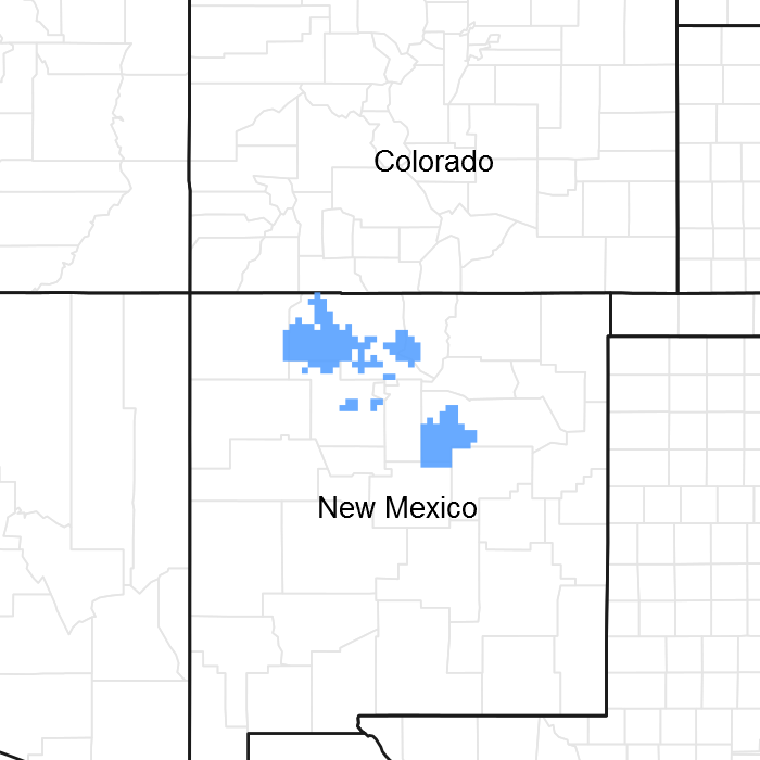
MLRA 36 occurs on the higher elevation portion of the Colorado Plateau. The Colorado Plateau is a physiographic province which exists throughout eastern Utah, western Colorado, western New Mexico and northern Arizona. It is characterized by uplifted plateaus, canyons and eroded features. The Colorado Plateau lies south of the Uintah Mountains, north of the Mogollon transition area, west of the Rocky Mountains, and east of the central Utah highlands. The higher elevation portion of the Colorado Plateau which is represented by MLRA 36 is characterize by broken topography, and lack of perennial water sources. This area has a long history of past prehistoric human use for years. MLRA 36 shows archaeological evidence indicating that pinyon-juniper woodlands where modified by prehistoric humans and not pristine and thus where altered at the time of European settlement (Cartledge & Propper, 1993). This area also included natural influences of herbivory, fire, and climate. This area rarely served as habitat for large herds of native herbivores or large frequent historic fires due to the broken topography. This site is extremely variable and plant community composition will vary with the water fluctuations on this site.
The lower part MLRA 36 developed under climatic conditions that include hot, dry summers with summer rains showers and little to no snow with the mild winter temperatures. This area has climatic fluctuations and prolonged droughts are common occurrences. Between an above average year and a drought year. Forbs are the most dynamic component of this community and can vary up to 4 fold (Passey et.al. 1982). The precipitation and climate of MLRA 36 are conducive to producing Pinyon/juniper, and sagebrush complexes with high productive sites in the bottoms of the canyons. Predominant species on the Colorado Plateau are Wyoming big sagebrush (Artemisia tridentata var. wyomingensis), mountain big sagebrush (A. tridentata var. vaseyana), and black sagebrush (A. nova), basin big sagebrush (A. tridentata var. tridentata), Utah juniper (Juniperus utahensis), one-seed juniper (Juniperus monosperma), and two-needle pinyon (Pinus edulis). One-seed juniper has the capability to discontinue active growth when moisture is limited but can resume growth when moisture availability improves. This growth pattern may represent an important adaptation allowing them to survive on very arid sites.
The ability for an ecological site to carry fire depends primarily on the present fuel load and plant moisture content—sites with small fuel loads will burn more slowly and less intensely than sites with large fuel loads. Fire is an important aspect of grass dominated ecological sites. LANDFIRE modelled southwest desert grasslands fire return interval as 10 to 833 years (USFS, 2012). Historically, fires were of mixed severity, and various patchy sizes which formed mosaics. Fires varied in intensity and frequency depending on the site’s productivity. So, the variability in severity, patchy sizes, intensity and frequency has led to large variabilities in the fire regimes and fire return intervals.
Shrub vegetation is able to reestablish from seed dispersal from the adjacent non burned shrub stands; however the process is relatively slow. Fire also decreases the extent of One-seed juniper/pinyon pine invasions, which allows the historic plant community to maintain integrity. When the plant community is burned shrubs decrease, while perennial and annual grasses increase. The perennial shrubs associated with this site are able to recover at a faster rate than the invading trees. When the site is degraded by the presence of invasive annuals, the fire return interval is shortened due to increased fuels. The shortened fire return interval is often sufficient to suppress the native plant community.
Variability in climate, soils, aspect and complex biological processes will cause the plant communities to differ. These factors contributing to annual production variability include wildlife use, drought, and insects. Factors contributing to special variability include soil texture, depth, rock fragments, slope, aspect, and micro-topography. The species lists are representative and not a complete list of all occurring or potentially occurring species on this site. The species lists are not intended to cover the full range of conditions, species and responses of the site. The State & Transition model depicted for this site is based on available research, field observations and interpretations by experts and could change as knowledge increases. As more data is collected, some of these plant communities may be revised or removed, and new ones may be added. The following diagram does not necessarily depict all the transitions and states that this site may exhibit, but it does show some of the most common plant communities.
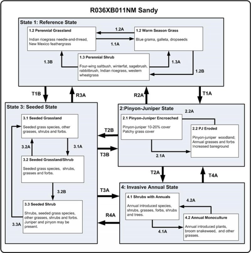
State 1
Reference
The reference state represents the plant communities and ecological dynamics of the Sandy site. This state includes the biotic communities that become established on the ecological site under the natural disturbance regime prior to pre-European settlement. The main pathways on this site are fire and drought. This is a grassland-shrub site predominantly characterized by perennial grasses and shrubs. Grasses are dominant and cover is fairly uniform with few large bare areas present. Indian ricegrass, needle-and-thread and New Mexico feathergrass are the dominant grass species. Dropseeds, galleta, squirreltail, western wheatgrass and blue gramacan also occur in significant amounts. Shrubs typical of this site may include fourwing saltbush, winterfat, big sagebrush, and sand sagebrush. In some areas, rubber rabbitbrush or spineless horsebrush may be more common. Annual forbs occur in high abundance in spring and summer month during years of above-average precipitation. Typically, species such as western wheatgrass, Indian ricegrass, New Mexico feathergrass, and winterfat decrease in response to a combination of heavy grazing and drought.
Reference state is self-sustaining and resistant to change due to high resistance to natural disturbances and high resilience following natural disturbances. When natural disturbances occur, the rate of recovery is variable due to disturbance intensity. Once invasive plants establish, return to the reference state may not be possible. Continuous, yearlong grazing, which allows repetitive grazing of the desirable species, eventually leads to a decrease in these species from the plant community. Such deterioration is indicated by a decrease in Indian ricegrass, needlegrasses, winterfat, and four-wing saltbush. Species that increase include blue grama, galleta, threeawns, sagebrush, and rubber rabbitbrush. One-seed juniper may invade this site from adjacent sites if the vigor of the herbaceous species decreases significantly.
Community 1.1
Perennial Grassland
This is a grassland-shrub site predominantly characterized by perennial grasses and shrubs. Grasses are dominant and cover is fairly uniform with few large bare areas present. This site provides a mixed grass-shrub aspect. Four-wing saltbush and winterfat are the dominant shrubs with big sagebrush and rubber rabbitbrush occurring in lesser amounts. Few, if any, trees occur on this site. Forbs are a minor component except during spring emergence. Indian ricegrass, needle-and-thread and New Mexico feathergrass are the dominant grass species.
Table 5. Annual production by plant type
| Plant type |
Low
(lb/acre) |
Representative value
(lb/acre) |
High
(lb/acre) |
| Grass/Grasslike |
375 |
525 |
675 |
| Shrub/Vine |
105 |
147 |
189 |
| Forb |
20 |
28 |
36 |
| Total |
500 |
700 |
900 |
Table 6. Soil surface cover
| Tree basal cover |
1-5%
|
| Shrub/vine/liana basal cover |
10-25%
|
| Grass/grasslike basal cover |
15-25%
|
| Forb basal cover |
1-5%
|
| Non-vascular plants |
0%
|
| Biological crusts |
0%
|
| Litter |
10-20%
|
| Surface fragments >0.25" and <=3" |
0%
|
| Surface fragments >3" |
0%
|
| Bedrock |
0%
|
| Water |
0%
|
| Bare ground |
50-70%
|
| Jan |
Feb |
Mar |
Apr |
May |
Jun |
Jul |
Aug |
Sep |
Oct |
Nov |
Dec |
| J |
F |
M |
A |
M |
J |
J |
A |
S |
O |
N |
D |
Community 1.2
Warm Season Grass
Blue grama is both drought and grazing resistant and may persist, but in a less productive, less vigorous form. This is a plant community phase that is dominated by blue grama with galleta and threeawns as subdominants may result. Western wheatgrass, blue grama, galleta will have increased while needle-and-thread, squirreltail and Indian ricegrass have decreased in abundance. Scattered shrubs, such as sagebrush, one-seed juniper and maybe two-needle pinyon might have encroached. Two-needle pinyon and One-seed juniper are natural invaders if stands are found adjacent to this site. Trees left uncontrolled can form dense stands and eventually dominate the site. Nonnative invasive species, such as cheatgrass may be present but in insignificant amounts. Bare ground is most common in this community phase.
Community 1.3
Perennial Shrub
This community consists mature shrubs with sparse understory. Scattered one-seed juniper and maybe two-needle pinyon might be present. Bare ground is most common in this community phase. Improper grazing use can aid the establishment of pinyon and juniper seedlings through reduced competition, exposure of mineral soil, and reduction of fuel to carry fires. This combined with increasing control of fires has caused large portions of the site to be taken over by pinyon and juniper since the coming of livestock. Two-needle pinyon and one-seed juniper are natural invaders if stands are found adjacent to this site. Trees left uncontrolled can form dense stands and eventually dominate the site. Sandy surface textures make this site susceptible to accelerated erosion if adequate herbaceous cover is not maintained. The loss of herbaceous cover due to overgrazing, fire suppression, and consequent surface soil horizon loss from water or wind facilitate the transition Pinyon-juniper state.
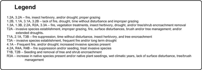
Pathway 1.1A
Community 1.1 to 1.2
This pathway favors shrub establishment. Events that cause this pathway are cause by time without disturbance (i.e. lack of fire), wet winter cycles, drought and improper grazing.
Pathway 1.2A
Community 1.2 to 1.1
This transition is caused by naturally occurring fires and/or drought. With a mature shrub community, this pathway can be caused by high intensity fire that burns hot enough to remove the mature shrubs. Low-intensity fire after the shrubs has had a chance to set seed, improper grazing and or browsing by native ungulates, and possible stem-root pathogens will revert a young shrubs community to a grassland with the potential to become a shrub-grass community once again.
Pathway 1.2B
Community 1.2 to 1.3
This transition is from the native shrub and perennial warm and cool season grass state, to a state that is dominated by mature shrubs. This pathway happens when fire does not occur within the historical fire regime interval for the site. Improper continuous grazing of perennial grasses will speed up this pathway. This will lead to an old decadent stand of shrubs with little to no understory. This allows the possibility of one-seed juniper and/or two-needle pinyon to become established on the site.
Pathway 1.3B
Community 1.3 to 1.1
Pathways can be one or more of the following: brush treatments, seeding, insect herbivory/pathogen, proper grazing, drought, and fire. Insect herbivory and/or root and stem pathogen die-off will thin the stands and allow perennial plants to establish if it is properly grazed.
Pathway 1.3A
Community 1.3 to 1.2
This pathway is caused by naturally occurring fires, drought and/or insect herbivory removes the shrubs and possible trees if they have encroached on this site. It reverts the system back to a grassland phase. Vegetation treatments can mimic this natural pathway.
State 2
Pinyon-Juniper
This state is characterized by a loss of grass cover and an increase in pinyon and juniper. Shrub species such as rubber rabbitbrush, spineless horsebrush, big sagebrush, and Bigelow sagebrush may also increase in representation. It is thought that pinyon and juniper, with an understory of mostly perennial grasses, may dominate the site in the longtime absence of fire, but lightning fires following warm dry early summer weather are a natural feature of the region. This could have maintained much of the site in a grassland cover, as reported by many early settlers except for occasional trees and isolated patches. Such vegetation is the basis for the potential described here. Without fire, simulated clearing methods may be necessary to maintain it (Miller and Tausch 2002). This state typically occurs when there is a long time span between fires. The transition to this state also has a reduction in fine fuels plays a part in increasing the fire return intervals once the site has transition to this pinyon-juniper state. Thus, state can persist for long time periods until the conditions needed for a fire occur or vegetation treatments are done to move the community to a different state.
Community 2.1
Pinyon-Juniper Encroached
It is dominated by a dense closed canopy of one-seed juniper and pinyon. They will be with a sparse understory of shrubs with little to no grass or forbs. Blue grama is typically the dominant grass. Galleta and dropseeds may also make up a significant proportion of the grass community. Evidence of erosion such as pedestalling of plants, elongated water flow patterns, litter dams, and rills may be common. Also, Invasive annuals grasses and forbs will be present in the understory.
Community 2.2
Pinyon-Juniper Eroded
This state has an overstory of one-seed juniper and/or two-needle pinyon with a very little understory of shrubs and few perennial grasses and forbs. There is very little herbaceous or other plant growth on this site. Grass cover is extremely sparse usually restricted to a few scattered patches of blue grama or widely scattered individual bunchgrasses. Large areas of bareground are present. The production and infiltration is low. Rills and small gullies are common. Litter is concentrated beneath pinyon-juniper canopies. Erosion is high, and the associated watersheds will become less stable and have more runoff.
State 3
Seeded
This state results from seeding introduced perennial grasses (i.e. crested wheatgrass and Russian wildrye). Native perennial grasses, forbs and shrubs may be included in the seed mix. This state behave similar community dynamics to the current potential state community. Other vegetation treatments may be necessary to get to this state, they include chaining, mowing, disking, prescribed burning and other techniques which manipulate the plant community. Applying vegetation treatments to plant communities to either the invasive annuals or pinyon-juniper encroachment states to create a seeded state is often the first step in assisted restoration to plant communities an intermediate step to get to the Reference State. The seeded state could persist for long periods of time with proper management. Native grasses and forbs may reestablish over time from nearby seed sources.
Community 3.1
Seeded Grassland
This community is dominated by seeded plants such as crested wheatgrass, Russian wildrye, smooth brome, and intermediate and pubescent wheatgrasses. Shrubs have little to no production in this phase. This site has high production due to the seed grass production. This production typically is higher than the current potential or reference state. This site usually has low species diversity.
Community 3.2
Seeded Grassland and Shrubland
This phase has shrubs co-dominant with the seeded grass.
Community 3.3
Seeded Shrubland
This community consists shrub overstory with sparse understory. Scattered one-seed juniper and maybe two-needle pinyon might have encroached. Two-needle pinyon and one-seed juniper are natural invaders if stands are found adjacent to this site. Trees left uncontrolled can form dense stands and eventually dominate the site. Nonnative invasive species, such as cheatgrass are present but in insignificant amounts. Bare ground is most common in this community phase.
Pathway 3.2A
Community 3.2 to 3.3
This pathway is caused by naturally occurring fires, herbivory of shrub, and/or drought that suppresses shrub establishment. These events tend to favor grass establishment. With a mature shrub community, this pathway can be caused by high intensity fire that burns hot enough to remove the shrubs and pinyon-juniper, if it has started to encroach. Low-intensity fire after the shrubs has had a chance to set seed, improper grazing and or browsing by native ungulates, and possible stem-root pathogens will revert a young shrub community back to a grassland with the potential to become a grassland community once again. Vegetation treatments (mechanically, prescribed fire, chemically, etc.) can also be employed to imitate the natural disturbances regime.
Pathway 3.3A
Community 3.3 to 3.3
This pathway is caused by naturally occurring fires, vegetation treatments (chemical and mechanical), and/or insect herbivory removes the shrubs and possible trees if they have encroached on this site. It reverts the system back to a grassland phase. Depending on the amount of understory present, grasses and forbs may need to be reseeded to aid reestablishment.
State 4
Invaded
This state is dominated by invasive annual species. Invasive annual species can including cheatgrass, Russian thistle, kochia, halogeton, storksbill geranium, and annual mustards. Generally as ecological conditions deteriorate and perennial vegetation decreases due to disturbance (fire, over grazing, drought, off road vehicle overuse, erosion, etc.) annual forbs and grasses will invade the site. The presence of these species will depend on soil properties and moisture availability; however, these invaders are highly adaptive and can flourish in many locations. Once established, complete removal is difficult but suppression may be possible.
Community 4.1
Shrubs with Annuals
This phase will look like shrub overstory with an invasive annual species understory. Frequently, shrub canopy cover will be dense due to little to none perennial understory being present. Cheatgrass, and other annual introduced species are now present in the understory. With repeated fire, it will then transition to an annual species plant community phase (4.2). This phase is at risk for becoming an annual grass-dominated community.
Community 4.2
Annual Monoculture
This community is characterized by an almost a complete monoculture of cheatgrass and/or other invasive annuals. This community can be long-lasting phase if fires and disturbance continue to be frequent.
Transition T1A
State 1 to 2
This transition is from the native shrub and perennial warm and cool season grass state, to a state that is dominated by two-needle pinyon and one-seed juniper. Events include time without disturbance, insect herbivory, continuous season long grazing of perennial grasses, drought, and tree invasion. As canopy density increase, bare ground will increase in size and frequency further increasing the fire return interval, accelerating erosion, increasing run-off and further affecting the watershed functionality. Loss of herbaceous cover can also reduce fuel levels beyond the point capable of carrying fire. This transition also favors the establishment of invasive annual species such as cheatgrass.
Transition T1B
State 1 to 3
This transition is from a shrub dominated state, to a state that has been seeded with introduced perennial grasses. High energy inputs are needed for this transition. Shrubs and/or trees will need to be removed with vegetation treatment techniques (I.e. chemical, mechanical, or fire) and introduced species that are adapted to the area and adapted to management needs have been seeded and become established.
Restoration pathway R2A
State 2 to 1
Pathways can be one or more of the following: brush treatments, seeding, insect herbivory/pathogen, proper grazing, drought, and/or fire. This pathway requires lots of energy input into the system. Prescribed grazing will help ensure adequate deferment period or rest following brush control and/or seeding, and will assist in the establishment and maintenance of grass cover. Erosion control would be necessary to prevent further nutrient and soil loss. The addition of organic matter or other soil amendments may be needed to restore soil fertility and facilitate grass recovery.
Transition T2B
State 2 to 3
Seeding of introduced/native species (grasses and forbs) is the pathway to state 3. Also, trees are usually removed by mechanical or chemical treatments. This transition requires energy input into the system.
Transition T2A
State 2 to 4
This transition is from a two needle pinyon and one-seed juniper state, to a state that is dominated by invasive species. Events would include establishment of invasive species, fire, and other methods of tree removal with an understory that is dominated by invasive annual species (i.e. cheatgrass).
Restoration pathway R3A
State 3 to 1
This return path could possible occur as a result of long time frames without disturbance. Native plants from adjacent site would slow establish in the seeded state. Proper grazing from livestock and wildlife which would favor the establishment of native plants. Removal of the one-seed juniper and pinyon as they encroach would also be necessary
Transition T3B
State 3 to 2
This transition is from the shrub-seeded grass state to a state that is dominated by two-needle pinyon and one-seed juniper. Events include, fire suppression, time without disturbance, insect herbivory, continuous season long grazing of perennial grasses, and tree invasion. As canopy density increase, bare ground will increase further increasing the fire return interval, accelerating erosion, increasing run-off and further affecting the watershed functionality. This transition also favors the establishment of invasive annual species such as cheatgrass.
Transition T3A
State 3 to 4
This transition is from a seeded state, to a state that is dominated by invasive species. Events include increased of invasive species, shortened fire return interval, and long term drought. Improper continuous season long grazing of perennial grasses can reduce the time needed for this pathway.
Transition T4A
State 4 to 2
This transition requires fire return intervals to length and fire suppression may be necessary to interrupted the shorten fire return intervals that occur when cheatgrass and other annuals invade. Juniper will encroach onto the site with time and lack of fire. Seeding may be necessary to establish perennial plants. This could require significant energy inputs to make this transition happen.
Restoration pathway R4A
State 4 to 3
Invasive annuals will need to be treated and dominance suppress enough to allow desired seeded species the ability to complete so that they can become established. Seeding of introduced species is the pathway to state 3. This transition will be difficult and require substantial inputs and management of the site. It may not be practical on a large scale. Research is needed for species adapted to compete with annual invasive plants, and seeding techniques to add with successful transition from the invasive annual state.