Ecological dynamics
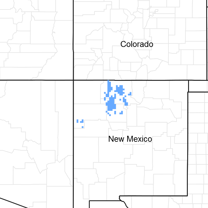
MLRA 36 occurs on the higher elevation portion of the Colorado Plateau. The Colorado Plateau is a physiographic province which exists throughout eastern Utah, western Colorado, western New Mexico and northern Arizona. It is characterized by uplifted plateaus, canyons and eroded features. The Colorado Plateau lies south of the Uintah Mountains, north of the Mogollon transition area, west of the Rocky Mountains, and east of the central Utah highlands. The higher elevation portion of the Colorado Plateau which is represented by MLRA 36 is characterize by broken topography, and lack of perennial water sources. This area has a long history of past prehistoric human use for years. MLRA 36 shows archaeological evidence indicating that pinyon-juniper woodlands where modified by prehistoric humans and not pristine and thus where altered at the time of European settlement (Cartledge & Propper, 1993). This area also included natural influences of herbivory, fire, and climate. This area rarely served as habitat for large herds of native herbivores or large frequent historic fires due to the broken topography. This site is extremely variable and plant community composition will vary with the water fluctuations on this site.
The lower part MLRA 36 developed under climatic conditions that include hot, dry summers with summer rains showers and little to no snow with the mild winter temperatures. This area has climatic fluctuations and prolonged droughts are common occurrences. Between an above average year and a drought year. Forbs are the most dynamic component of this community and can vary up to 4 fold (Passey et.al. 1982). The precipitation and climate of MLRA 36 are conducive to producing Pinyon/juniper, and sagebrush complexes with high productive sites in the bottoms of the canyons. Predominant species on the Colorado Plateau are Wyoming big sagebrush (Artemisia tridentata var. wyomingensis), mountain big sagebrush (A. tridentata var. vaseyana), and black sagebrush (A. nova), basin big sagebrush (A. tridentata var. tridentata), Utah juniper (Juniperus utahensis), one-seed juniper (Juniperus monosperma), and two-needle pinyon (Pinus edulis). One-seed juniper has the capability to discontinue active growth when moisture is limited but can resume growth when moisture availability improves. This growth pattern may represent an important adaptation allowing them to survive on very arid sites. It is possible that small trees may be killed by drought; mature one-seed junipers are resilient to drought, especially in comparison to two-needle pinyon (Johnsen, 1962).
This ecological site is located in draws, small valley bottoms and drainage-ways on the Colorado Plateau. Herbivory and fire are the dominant disturbance factors in the sagebrush biome (Boyd et. al., 2014). Removal or repeatedly detrimental application of either of these disturbances on the system and/or the landscape can result in a shift of the ecological dynamics of this system. The ecological dynamics of the associated uplands are influential to the dynamics of this site. Excessive runoff and erosion from degraded uplands can increase concentrated flow and increased potential erosion towards gully formation. This site is located in the bottoms where fire occurred more frequently, removing brush and keeping it in a grassland state.
The plant community on this site is very productive and relatively resilient compared to its surrounding uplands. It has deep soils with good water holding capacity that receive a large amount of moisture from run-in and overflow water. Because of these factors many of these sites are now or once were cleared and converted to agricultural lands depending on their accessibility.
This site is dominated by perennial grasses but shrub species are present with Basin Big Sagebrush. Although, this site evolved with grazing and is relatively durable, it will be affected negatively with continuous heavy grazing pressure. Livestock are attracted to these sites because they are so productive and these sites lie in low areas with gentle slopes. Proper distribution of livestock is critical. Appropriate placement of fencing, water, and salt/supplement is necessary. Heavy grazing combined with drought and/or lack of fire, will cause this site to become shrub dominant. As shrubs increase and perennials are weakened due to heavy grazing and/or drought, undesirable annuals such as cheatgrass may invade the site. As perennial grasses with fibrous root systems are replaced by weaker annuals, erosion may occur more rapidly. Runoff from the uplands can cause channels to form and incise dropping the water table. As soils dry out, greasewood may begin to invade into these sites. This seems to occur more frequently at lower elevations.
Soils, topographic location, climate, periodic droughts and fire influenced the stabilization of the Reference State on this site as was the case on most drainage-ways and draws ecological sites. The Reference State is presumed to be as found by European settlers in the early 1800's developed under the prevailing climate over time along with the soils in their topographic location. Grazing and/or browsing by wildlife influenced the plant community as well. Sagebrush below 8500 feet has been slower to recover from settlement of the west (Winward, 2004). This site has been found to have basin big sagebrush.
Fire size prior to 1850 were most likely a large number of small to medium size mosaic burns and since 1980 can be typified by a few very large fires due to human caused changes (Evers, et al, 2011). This change in fire return intervals and intensities was cause by fire suppression and reduced fine-fuels from livestock grazing practices around the late 1800’s and early 1900’s. Since fire is not always available to be applied, then other shrub management may necessary from time to time to help keep the community in balance. Treatment response will vary among sites due to differences in vegetation composition and abundance, soils, elevation, aspect, slope and climate (McIver, et al, 2010).
Natural fire played an important role in the function of most upland sites. Fire keeps sagebrush stands from getting too dense, while invigorating other sprouting shrubs. Fire helped to keep a balance between the grasses, forbs and shrubs. Plant community dynamics were improved by opening up canopies and stimulating forb growth creating a mosaic of different age classes and species composition. Shrubs which re-sprout (yellow rabbitbrush, rubber rabbitbrush), are suppressed for a time allowing grasses to dominate. If periodic fire or some other method of brush control is not used, then sagebrush will slowly increase and can begin to dominate the site.
There has been shrub die-off in several sagebrush taxa in the past 10-15 years due to several factors. The two dominant factors are disease/pathogens and drought. Die-off due to disease/pathogens is believed to be tied to disease or stem/root pathogens occurring in dense over-mature sagebrush stands throughout the west. While in some areas, when the factors of drought and heavy browsing occurring in conjunction with disease/pathogens complete areas are dying.
Small wet areas can occur occasionally when the bottoms are very narrow and small, allowing for more water accumulation. This may support willows, sedges and rushes and may be a small inclusion of a wet meadow or salt meadow ecological site. Cottonwoods (Fremont and/or Narrowleaf) can occasionally be found in these inclusion areas. Cottonwood are reported to be a facultative wetland species which are tolerant of frequent and prolonged flooding and are not drought resistant (Simonin, 2001). This site is typically too dry to sustain cottonwoods.
A weedy community that has not been depicted on the model can arise if domestic grazing is completely excluded or if there is repetitive, season-long, heavy domestic or wild ungulate use. With grazing exclusion, a thick thatch of residual litter build-up results in shading and a reduction of health, vigor and production of all plants. Improper domestic and wild ungulate grazing use results in preferred species being repeatedly clipped which decreases their health, vigor and production. Both make a site susceptible to invasion by noxious and/ unsuited species.
Few, of any fire histories have been conducted on basin big sagebrush. It is suggests that fire return intervals in basin big sagebrush are intermediate between mountain big sagebrush and Wyoming big sagebrush (Tirmenstein, 1999). Wyoming big sagebrush communities are less prone to fire than mountain big sagebrush. Wyoming big sagebrush communities in the western United States have fire return intervals ranging from 10-115 years (West and Hassan 1985, Evers, et al, 2011, Johnson, 2000). Fire return intervals for Wyoming big sagebrush vary greatly depending on locale differences in precipitation and temperature. The fire return interval habitats with mountain big sagebrush is 10 to 40 years (Boyd et. al., 2014, Johnson, 2000). Johnson (2000) states that basin big sagebrush fire regime is 12 to 43 years. LANDFIRE models fire regimes of Basin and Wyoming Big Sagebrush communities have been found to have a fire interval of 33 to 116 years (USDA, 2012). LANDFIRE data is for general vegetation types in the United States: no specific data for basin big sagebrush dominated sites exist on Colorado Plateau at available at this time.
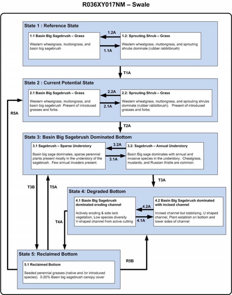
Variability in climate, soils, aspect and complex biological processes will cause the plant communities to differ. These factors contributing to annual production variability include wildlife use, drought, and insects. Factors contributing to special variability include soil texture, depth, rock fragments, slope, aspect, and micro-topography. The species lists are representative and not a complete list of all occurring or potentially occurring species on this site. The species lists are not intended to cover the full range of conditions, species and responses of the site. The State & Transition model depicted for this site is based on available research, field observations and interpretations by experts and could change as knowledge increases. As more data is collected, some of these plant communities may be revised or removed, and new ones may be added. The following diagram does not necessarily depict all the transitions and states that this site may exhibit, but it does show some of the most common plant communities.
State 1
Reference
The reference state contains plant communities presumed to occur prior to the introduction of nonnative plants, livestock grazing, and other modern disturbances. Basin big sagebrush dominance depends on time since fire, insect outbreak or extended drought. In both communities the grasses are the dominant component.
It is a very diverse community with 10-20 or more species present throughout the site. This diversity adds to a site’s stability. Often, decreasing diversity can be one of the first indicators of site deterioration. Key species that indicate a pristine and functioning system include. Species that often act as increasers with disturbance and indicate a deteriorating site include: basin big sagebrush, white sagebrush, squirreltail, foxtail barley, broom snakeweed, and rabbitbrush. This site has less than 20% big sagebrush canopy cover. The percentage of shrubs in this state will fluctuate depending on frequency and intensity of disturbances such as fire, or grazing. Typically the sage brush increases until fire is introduced to the system. Following the fire, rabbitbrush and annual forbs will increase creating a rabbitbrush phase that will be phased out as perennial grasses and sagebrush reestablish themselves
Grazing distribution on adjacent sites may be a problem since grazing animals are attracted to this site due to early green-up. Such continuous, heavy grazing pressure, as well as trampling damage on wet soils, may lead to deterioration of the potential plant community. The result is a decrease in western wheatgrass, spike muhly, muttongrass, prairie junegrass, and fourwing saltbush. Plant species that increase include blue grama, mat muhly, basin big sagebrush, rubber rabbitbrush, and broom snakeweed. Serious deterioration is represented by a sodbound cover of blue grama or total dominance by basin big sagebrush, both in low in production.
Community 1.1
Basin Big Sagebrush and Grass
Typically, this is a grassland site with scattered shrubs. Western wheatgrass is the dominant grass on this site with basin big sagebrush and fourwing saltbush providing a shrub savannah aspect. Forbs are a minor component on the site.
Table 5. Annual production by plant type
| Plant type |
Low
(lb/acre) |
Representative value
(lb/acre) |
High
(lb/acre) |
| Grass/Grasslike |
680 |
1063 |
1445 |
| Shrub/Vine |
80 |
125 |
170 |
| Forb |
40 |
62 |
85 |
| Total |
800 |
1250 |
1700 |
Table 6. Soil surface cover
| Tree basal cover |
0%
|
| Shrub/vine/liana basal cover |
3-13%
|
| Grass/grasslike basal cover |
25-35%
|
| Forb basal cover |
1-5%
|
| Non-vascular plants |
0%
|
| Biological crusts |
0%
|
| Litter |
25-35%
|
| Surface fragments >0.25" and <=3" |
0%
|
| Surface fragments >3" |
0%
|
| Bedrock |
0%
|
| Water |
0%
|
| Bare ground |
32-43%
|
| Jan |
Feb |
Mar |
Apr |
May |
Jun |
Jul |
Aug |
Sep |
Oct |
Nov |
Dec |
| J |
F |
M |
A |
M |
J |
J |
A |
S |
O |
N |
D |
Community 1.2
Sprouting Shrub and Grass
Sprouting shrubs make up most of the shrub component. Rabbitbrush is a re-sprouter and will increase after disturbance. This phase is usually the result of fire that eliminates basin big sagebrush dominance for the space of several years. Sagebrush will begin to re-establish in the community following fire, and will steadily increase in the community until it becomes co-dominant with the perennial grass. However it can be difficult to move this community back to the community phase 1.1.
Pathway 1.1A
Community 1.1 to 1.2
Sprouting shrubs increase due to disturbance. Stand-replacing fire of sagebrush is the most common historical cause of this community pathway. Sagebrush decreases and perennial grasses, forbs, and sprouting shrubs (i.e. rabbitbrush) dominate the site. Insect outbreak, low intensity fires, and prolonged drought may also result in a substantial decrease in sagebrush, but do not necessarily eliminate it from the community. Repetitive burning of big sagebrush favors rabbitbrush and perennial grasses. Mechanical and chemical removal of sagebrush can often release rabbitbrush on this site. This may be a timing of treatment issue or one related to the weather patterns in years surrounding the treatment. Chemical treatment, physical means (i.e. mowing) and/or prescribed fire often are attempted to remove invading sagebrush.
Pathway 1.2A
Community 1.2 to 1.1
This pathway results from the establishment and natural increase of basin big sagebrush into the plant community years following a fire. Proper grazing use, herbivory on sprouting shrubs, and time should allow this community to transition to plant community 1.1. Brush management practices may be necessary if the rabbitbrush and bareground has increased. Repetitive brush treatment may be needed.
State 2
Current Potential
The current potential state is similar to the reference state, however invasive species are present in all community phases. This state is generally dominated by big sagebrush, however depending on disturbance history, native grasses, forbs, or other shrubs may dominate the site. Primary disturbance mechanisms include fire, native herbivore grazing, insect outbreak, domestic livestock grazing and surface disturbances, (i.e. road and pipeline development and off road vehicle (OHV) use). Timing of these disturbances dictates the ecological dynamics that occur. The current potential state is self-sustaining; but is losing resistance to change due to lower resistance to disturbances and lower resilience following disturbances. When disturbances occur, the rate of recovery is variable depending on severity. The current potential state is similar in structure and function to the reference state, however invasive and non-natives species are present in all community phases. The current potential state is generally dominated by perennial grasses.
Community 2.1
Basin Big Sagebrush and Grass
Phase 2.1 is similar to the reference plant community in composition and ecological function, but it allows for the presence of non-native/invasive species.
Community 2.2
Sprouting Shrub and Grass
Sprouting shrubs make up most of the shrub component. Phase 2.2 annual production is dominated by perennial grasses. It is similar to phase 1.2 in composition and ecological function, but allows for non-native/invasive species to be present. Sprouting shrubs make up most of the shrub component. Rabbitbrush is a re-sprouter and will increase after disturbance. This phase is usually the result of fire that eliminates basin big sagebrush dominance for the space of several years. Sagebrush will begin to re-establish in the community following fire, and will steadily increase in the community until it becomes co-dominant with the perennial grass. However it can be difficult to move this community back to the community phase 2.1.
Pathway 2.1A
Community 2.1 to 2.1
Sprouting shrubs increase due to disturbance. Stand-replacing fire of sagebrush is the most common historical cause of this community pathway. Sagebrush decreases and perennial grasses, forbs, and sprouting shrubs (i.e. rabbitbrush) dominate the site. Insect outbreak, low intensity fires, and prolonged drought may also result in a substantial decrease in sagebrush, but do not necessarily eliminate it from the community. Repetitive burning of big sagebrush favors rabbitbrush and perennial grasses. Mechanical and chemical removal of sagebrush can often release rabbitbrush on this site. This may be a timing of treatment issue or one related to the weather patterns in years surrounding the treatment. Chemical treatment, physical means (i.e. mowing) and/or prescribed fire often are attempted to remove invading sagebrush.
State 3
Basin Big Sagebrush Dominated
This is a degraded state and the hydrology of this site has been altered. The plant community and surface debris are no longer capable of slowing runoff and dissipating the water’s erosive energy. In flow events, fine organic materials are not present to stabilize soil, slow water and allow infiltration. Instead, water from the uplands builds energy as it collects in the bottom and begins to form a channel. As the water becomes more channelized, the bottom becomes even less capable of dissipating the energy and channelization increases moving down the system and a head-cut start moving up the system.
This state has two fluctuating phases. Both phases have an entrenched channel where water has no access to the bottom floodplain and although vegetation in the channel may return to a community similar to the current potential (if not a little wetter), the majority of the bottom remains in the degraded sagebrush dominated state producing only a fraction of its original potential. The first community is the least stable with high levels of erosion occurring with any flow event. There is no vegetation on the sidewalls or the bottom of the channel. It has a distinctly V shaped channel profile that widens and deepens with every flow event. The second community is where healing is occurring and he bottom of the channel has become re-vegetated. The vegetation is similar to that of the current potential community with some exception. Since there is the same amount of water consolidated to a smaller area, the soils have a greater potential to show gleying and redoximorphic features that indicate low oxygen environments that are associated with the presence of a water table. Thus, plants that often inhabit the channel are those that have a greater tolerance for flooding. This means that often the amount of obligate and facultative wetland species are increased beyond that of the reference plant community. The channel vegetation helps to hold the channel in minor to moderate flooding events and prevent further degradation. Often sites in this phase develop U shaped profiles.
Community 3.1
Sagebrush, Sparse Understory
The dominate plants have changed from perennial grasses and forbs to big sagebrush. Most perennial plants have been lost from the understory and the ones that are present are usually found under the shrub canopy. Basin big sagebrush continues to increase beyond the natural fire return interval due to lack of fuel to carry a fire. Moderate and large flow events can result in immense amounts of erosion. A bottom that was once a depositional zone prior to sagebrush invasion can become at risk for developing deeply eroded channels and contribute to higher stream sediment loads.
Community 3.2
Sagebrush, Annual Understory
This phase is dominated by basin big sagebrush in the overstory and annual introduced grasses and/or forbs in the understory.
Pathway 3.1A
Community 3.1 to 3.2
With Basin big sagebrush increasing and sagebrush decadence increasing, cover changes in this communities can brought on by prolonged drought, lack of fire, surface disturbances, (i.e. road and pipeline development and off road vehicle (OHV) use), and improper grazing use can create alterations in the plant community that can leave the soils at risk for erosion and alter the hydrological function. Improper grazing of perennial grasses during growth has favored non-native invasive species, primarily cheatgrass and/or Russian thistle, to co-dominate the understory. Few remnant plants may still persist under shrubs, but re-establishment and dominance by perennial grasses will not occur following a fire, or with the removal of grazing animals in the natural time frame.
Pathway 3.2A
Community 3.2 to 3.1
This pathway occurs when basin big sagebrush is reduced by fire, insect outbreak, wetter climatic cycles or other another disturbances. As perennial grasses are slowly establishing due to proper grazing and less competition from basin big sagebrush. There still is accelerated erosion that can lead to increased channelization in flow areas.
State 4
Degraded
This is a degraded state and the hydrology of this site has been altered. The plant community and surface debris are no longer capable of slowing runoff and dissipating the water’s erosive energy. In flow events, fine organic materials are not present to stabilize soil, slow water and allow infiltration. Instead, water from the uplands builds energy as it collects in the bottom and begins to form a channel. As the water becomes more channelized, the bottom becomes even less capable of dissipating the energy and channelization increases moving down the system and a head-cut start moving up the system.
This state has two fluctuating phases. Both phases have an entrenched channel where water has no access to the bottom floodplain and although vegetation in the channel may return to a community similar to the current potential (if not a little wetter), the majority of the bottom remains in the degraded sagebrush dominated state producing only a fraction of its original potential. The first community is the least stable with high levels of erosion occurring with any flow event. There is no vegetation on the sidewalls or the bottom of the channel. It has a distinctly V shaped channel profile that widens and deepens with every flow event. The second community is where healing is occurring and he bottom of the channel has become re-vegetated. The vegetation is similar to that of the current potential community with some exception. Since there is the same amount of water consolidated to a smaller area, the soils have a greater potential to show gleying and redoximorphic features that indicate low oxygen environments that are associated with the presence of a water table. Thus, plants that often inhabit the channel are those that have a greater tolerance for flooding. This means that often the amount of obligate and facultative wetland species are increased beyond that of the reference plant community. The channel vegetation helps to hold the channel in minor to moderate flooding events and prevent further degradation. Often sites in this phase develop U shaped profiles.
Community 4.1
Basin Big Sagebrush Dominated, Eroding Channel
This community is the least stable community within this state. This state has actively eroding channel with active head-cuts at the top of the eroding channel. There are high levels of erosion occurring with any flow event due to the lack of vegetation on the sidewalls and the bottom of the channel. Often there is a distinctly V shaped channel that widens and deepens with every flow event. Bareground has increased and herbaceous production has been reduced. There is very low species diversity and a majority of the forbs are gone from the community. The site is eroding to create a partially abandoned bottom that will look like a drier sagebrush bench above a narrower channel (bottom).
Community 4.2
Basin Big Sagebrush Dominated, Incised Channel
The second community is where healing is occurring. The bottom of the channel has become re-vegetated with plants similar to that of the reference community with some exception. Since there is the same amount of water consolidated to a smaller are, the soils have a greater potential to show gleying and redoximorphic features that are associated with the presence of a water table. Thus, plants that often inhabit the channel are those that have a greater tolerance for prolonged flooding. This means that often the amount of obligate and facultative wetland species are increased beyond that of the reference plant community. The channel vegetation helps to stabilize the channel in minor to moderate flooding events. Often sites in this phase develop “U” shaped profiles. Side slopes remain denuded and thus there is still potential for erosion. There can be a sagebrush “bench” (elevated sagebrush topslopes with relict reference state vegetation) along a narrow and entrenched channel.
Pathway 4.2A
Community 4.2 to 4.1
Seasonal drought, improper grazing use, regional and fire, and large flow events can all contribute to this community’s further degradation.
State 5
Reclaimed
This community is a man-made community. To get to this state requires a lot of inputs and hard work, but it can be done. Time, energy and resources are needed to restore the water table to the floor of the bottom and not the bottom of the channel.
Community 5.1
Reclaimed Bottom
This is the community phase after the work is done to restore the water table to the floor of the bottom. Often a large amount of dirt work, brush removal and the installation of check dams are required to reclaim the bottom community. Even then, the community may never be that of the reference plant community. Areas directly behind the check structures often have a higher water table and promote facultative and obligate wetland species. Areas directly below the structures are not getting the subterranean flow that was present in the original bottom and thus are drier and promote invasion by upland species that are not typical in the reference plant community. This site will need to be monitored to see if additional work will need to be done once original check dams fill up with sediment. This site could need to be seeded to help stabilize it.
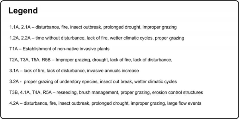
Transition T1A
State 1 to 2
This transition is from the native perennial warm and cool season grass understory in the reference state to a state that contains invasive species. Plant may include cheatgrass, annual mustards, thistles, knotweeds, and dandelion. Events include establishment of invasive plant species, intense continuous grazing of perennial grasses, prolonged drought, and/or surface disturbances, etc. However, invasive species such as cheatgrass have been known to invade intact perennial plant communities with little to no disturbance. Once invasive species are found in the plant community a threshold has been crossed.
Transition T2A
State 2 to 3
This pathway occurs when perennial grasses are reduced in the understory due to improper grazing and/or drought during the growing period. With Basin big sagebrush increasing and sagebrush decadence increasing, cover changes in this communities can brought on by prolonged drought, lack of fire, and improper grazing use can create alterations in the plant community that can leave the soils at risk for erosion and alter the hydrological function. Also, lack of wet periods to drown out big sagebrush and increase completion from the shallower root grasses and forbs can cause this shift from State 2 to State 3 - sagebrush dominated. Few remnant plants may still persist under shrubs, but re-establishment and dominance by perennial grasses will not occur following a fire, or with the removal of grazing animals in the natural time frame. Nonnative species may co-dominate the understory.
Transition T3A
State 3 to 4
The site has become unstable. This is a very quick transition. Due to the lack of soil protection large flow events quickly destabilize the site and it transitions to the state with altered hydrological function (4). Anything that further reduces ground cover, like improper grazing use and continued drought, has potential to quicken this transition. Fire suppression and lack of shrub management in decadent sagebrush uplands continue to promote altered hydrologic function and also aid in destabilizing the bottom. The lack of adequate herbaceous cover to dissipate water velocity and encourage infiltration result in the formation of gullies and head-cuts.
Transition T3B
State 3 to 5
To restore the site to the current potential state extreme inputs are necessary. This transition is from a big sagebrush dominated state, to a state that has been seeded with introduced or native perennial grasses. High energy inputs are needed for this transition. Sagebrush will need to be removed with vegetation treatment techniques (I.e. chemical, mechanical, or fire) and introduced or native species that are adapted to the area and adapted to management needs have been seeded and become established. Proper grazing use by both domestic animal and wildlife needs to occur. Often successful on small scales over very long periods of time, large scale restoration projects are not often able to be fully restored. This pathway would require continued sedimentation, proper grazing use, and proper hydrologic contributions.
Management practices that restore upland community health and functioning are critical to restoring a sagebrush dominated bottom to the current potential state. Such practices can include shrub management, and reseeding. Erosion control structures may be necessary. This needs to be used in conjunction with proper grazing management. Several wet years in a row can also decrease big sagebrush, as big sagebrush does not like to have it roots in water for extended periods of time.
Restoration pathway R5A
State 5 to 2
This restorative pathway from the State 5 to the State 2 is very intensive. Often successful on small scales over very long periods of time, large scale restoration projects are not often able to be fully restored. This pathway would require continued sedimentation, proper grazing use, and proper hydrologic contributions. This community may reestablish the same hydrological function as in the reference state if the contributing upland sites provide the hydrologic contributions.
Transition T5A
State 5 to 3
Sagebrush encroachment with increasing sagebrush decadence and cover in adjacent upland communities brought on by prolonged drought, lack of fire, and improper grazing use can create alterations in the plant community that can leave the soils at risk for erosion and alter the hydrological function.
Restoration pathway R5B
State 5 to 4
This community becomes unstable, affects soil health and the hydrologic function as it is invaded by big sagebrush. The lack of adequate herbaceous cover to dissipate water velocity and encourage infiltration result in the formation of gullies and head-cuts. This is a very quick transition. Due to the lack of soil protection large flow events quickly destabilize the site and it transitions to the state with altered hydrological function (3). Anything that further reduces ground cover, like improper grazing use and continued drought, has potential to quicken this transition. Fire suppression and lack of shrub management in decadent sagebrush uplands continue to promote altered hydrologic function and also aid in destabilizing the bottom.