Provisional. A provisional ecological site description has undergone quality control and quality assurance review. It contains a working state and transition model and enough information to identify the ecological site.
Areas shown in blue indicate the maximum mapped extent of this ecological site. Other ecological sites likely occur within the highlighted areas. It is also possible for this ecological site to occur outside of highlighted areas if detailed soil survey has not been completed or recently updated.
MLRA notes
Major Land Resource Area (MLRA): 036X–Southwestern Plateaus, Mesas, and Foothills
R036XB138NM – Marshy is an ecological site that on abandoned channels on flood plains of valley floors in MLRA 36 (Southwestern Plateaus Mesas and Foothills). The southern portion MLRA 36 is illustrated yellow color on the map where this site occurs. The site concept was established in the Southwestern Plateaus. Mesas, and Foothills – Warm Semiarid Mesas and Plateaus LRU (Land Resource Area). This LRU has 10 to 16 inches of precipitation and has a mesic temperature regime. Lower part of MLRA 36 is dominated by summer precipitation for monsoons, unlike the upper part of MLRA 36 which is almost an equal split.
Classification relationships
NRCS & BLM:
Major Land Resource Area 36, Southwestern Plateaus Mesas and Foothills (United States Department of Agriculture, Natural Resources Conservation Service, 2006).
USFS:
313Bd Chaco Basin High Desert Shrubland and 313Be San Juan Basin North subsections < 313B Navaho Canyonlands Section < 313 Colorado Plateau Semi-Desert (Cleland, et al., 2007).
315Ha Central Rio Grande Intermontane, and 315Hb North Central Rio Grande Intermontane subsections <315H Central Rio Grande Intermontane Section < 315 Southwest Plateau and Plains Dry Steppe and Shrub (Cleland, et al., 2007).
315Ad Chupadera High Plains Grassland subsections <315A Pecos Valley Section < 315 Southwest Plateau and Plains Dry Steppe and Shrub (Cleland, et al., 2007).
331Jb San Luis Hills and 331Jd Southern San Luis Grasslands subsections <331J Northern Rio Grande Basin Section < 331 Great Plains- Palouse Dry Steppe (Cleland, et al., 2007).
20c Semiarid Benchlands and Canyonlands < 20 Colorado Plateaus < 10.1 Cold Deserts < 10 North American Deserts (Griffith, 2006).
22m Albuquerque Basin, 22i San Juan/Chaco Tablelands and Mesas, 22h North Central New Mexico Valleys and Mesas, 22f Taos Plateau, and 22g Rio Grande Floodplain, < 22 Arizona/New Mexico Plateau < 10.1 Cold Deserts < 10 North American Deserts (Griffith, 2006).
USGS:
Colorado Plateau Province (Navajo and Datil Section) Southern Rocky Mountains Basin and Range (Mexican Highland and Sacramento Section)
Ecological site concept
The 36XB ecological site was drafted from the existing R036XB008NM – Meadow range site MLRA 36XB (NRCS, 2003). This site is commonly located on abandoned channels on flood plains of valley floors. The soils are deep, very poorly drained. The seasonal water table fluctuates between 0 and 5 inches for most of the growing season. The surface layer texture is usually a silt loam with 8% clay on average. The subsoils are coarse-loamy textured. The subsurface is usually a silt loam, fine sandy loam, loamy sand, coarse sand, gravelly coarse sand and gravelly loamy coarse sand with approximately 14% clay. It has an aridic ustic/ustic arid moisture regime and mesic temperature regime. The effective precipitation ranges from 10 to 16 inches.
This site is enhanced by runoff during periods of high runoff (intermittent). The water table depth is greater than 6 ft. Soils are deep to very deep soils that have surface textures of loams, silt loams to clays with loamy subsoil. Landforms are broad valley bottoms, floodplains, and in depressions.
Water table 28-72” in depth; slopes 1-5%; soils are deep, Surface textures are silty clay loam, and clay loam with a subsoil of stratified loams, silt loams, silty clay loams, clay loams, very gravelly sand and gravelly sand. Landform is nearly level to gently sloping floodplains.
Water table 36-72” in depth; slopes are 1-5%; soils are deep, Surface textures are loam, fine sandy loam, clay loam, silty clay loam with a subsoil of clay or clay loam. Landform is nearly level to gently sloping floodplains. This site is dependent on sub-irrigation and overflow for its moist condition. This site is affected by sodium
This site is located on abandoned channels on flood plains of valley floors with intermittent streams. They formed in alluvium derived from Precambrian granite, gneiss, and schist and Tertiary micaceous sandstone and siltstone. Slopes are 0 to 1 percent. Elevation ranges from 5,500 to 6,600feet.
Table 2. Representative physiographic features
Landforms
(1) Valley floor (2) Channel (3) Marsh
Flooding duration
Extremely brief (0.1 to 4 hours)
Flooding frequency
None to occasional
Ponding duration
Very long (more than 30 days)
Ponding frequency
Frequent
Elevation
5,500–6,600 ft
Slope
1%
Ponding depth
4 in
Water table depth
5 in
Aspect
Aspect is not a significant factor
Climatic features
This site has a semi-arid continental climate. There are distinct seasonal temperature variations. Mean annual precipitation varies from 10 to 16 inches. The overall climate is characterized by cold dry winters in which winter moisture is less than summer. Wide yearly and seasonal fluctuations are common for this climatic zone which can range from 5 to 25 inches. Of this, approximately 25-35% falls as snow, and 65-75% falls as rain between April 1 and November 1. The growing season is April through September. As much as half or more of the annual precipitation can be expected to come during the period of July through September. August is typically the wettest month of the year. The driest period is usually from November to April; and February is normally the driest month. During July, August, and September, 4 to 6 inches of precipitation influence the presence and production of warm-season plants. Fall and spring moisture is conducive to the growth of cool-season herbaceous plants and maximum shrub growth. Growth usually begins in March and ends with plant maturity and seed dissemination when the moisture deficiency and warmer temperatures occur in early June. There is also a period of growth in the fall. Summer precipitation is characterized by brief thunderstorms, normally occurring in the afternoon and evening. Winter moisture usually occurs as snow, which seldom lies on the ground for more than a few days. The average annual total snowfall is 29.1 inches. The snow depth usually ranges from 0 to 1 inches during the winter months. The highest snowfall record is 57.1 inches during the 1993-1994 winter. The frost- free period typically ranges from 110 to 145 days and the freeze free period is from 140 to 170 days. The last spring freeze is the middle of April to the first week of May. The first fall freeze is the middle of October to the first week of November. Mean daily annual air temperature is about 29ºF to 69ºF, averaging about 37ºF for the winter and 67ºF in the summer. The coldest winter temperature recorded was -20ºF on January 6, 1971 and the warmest winter temperature recorded was 70ºF on February 28, 1965. The coldest summer temperature recorded was 26ºF on June 1, 1980. The hottest day on record is 100ºF on July 9, 2003 and June 21, 1968. Data taken from Western Regional Climate Center (2017) for El Rito, New Mexico Climate Station.
Table 3. Representative climatic features
Frost-free period (average)
126 days
Freeze-free period (average)
145 days
Precipitation total (average)
13 in
Bar
Line
Figure 2. Monthly precipitation range
Bar
Line
Figure 3. Monthly average minimum and maximum temperature
Figure 4. Annual precipitation pattern
Figure 5. Annual average temperature pattern
Climate stations used
(1) SANTA FE 2 [USC00298085], Santa Fe, NM
(2) CUBA [USC00292241], Cuba, NM
(3) ABIQUIU DAM [USC00290041], Gallina, NM
(4) COCHITI DAM [USC00291982], Pena Blanca, NM
(5) EL RITO [USC00292820], El Rito, NM
(6) LYBROOK [USC00295290], Dulce, NM
(7) NAVAJO DAM [USC00296061], Navajo Dam, NM
Influencing water features
Slightly concave abandoned channel of a flood plain sloping 1 percent to the northwest at 6,220 feet elevation--wet meadow. Soil moisture - The soil moisture control section is wet throughout the year. The soil moisture regime is peraquic.
Very poorly drained; high surface runoff; moderate and moderately rapid permeability in the upper part of the profile and rapid and very rapid permeability in the lower part of the profile. These soils are subject to occasional, extremely brief periods of flooding between July and September. Floodwaters have low velocity and are generally less than 1 foot deep. A seasonal high water table is present between the soil surface and 1.0 foot.
Soil features
Soils are very deep (60+ inches). These soils are coarse-loamy textured. The soils are dark in color for the organic matter that occurs on this site. This site may have a peat layer occurring. Redox features are commonly found in the soils between 0 and 2 inches in depth. The surface layer texture is usually a silt loam with 8% clay on average. The subsoils are coarse-loamy textured. The subsurface is usually a silt loam, fine sandy loam, loamy sand, coarse sand, gravelly coarse sand and gravelly loamy coarse sand with approximately 14% clay.
The soils show signs of poor drainage. They are wet most of the year, but in late summer they may show signs of drought. The variability of the duration and height of the water table causes considerable variation in plant growth over the site. The parent materials are micaceous alluvium derived from sandstone and siltstone and/or alluvium derived from granite and/or alluvium derived from gneiss and/or alluvium derived from schist and/or alluvium derived from micaceous sandstone and siltstone, and granite, gneiss, or schist. The soil moisture and temperature regimes are ustic aridic and mesic respectively.
This site is found in NM672, NM678, NM686 and NM687 soil survey. This ecological site has been correlated to the following soils with the listed particle control sections:
Coarse-Loamy
Mirada
Table 4. Representative soil features
Parent material
(1) Alluvium–sandstone and siltstone (2) Alluvium–granite (3) Alluvium–gneiss
Surface texture
(1) Silt loam
(2) Fine sandy loam
Family particle size
(1) Sandy
Drainage class
Very poorly drained
Permeability class
Moderate to moderately rapid
Soil depth
60 in
Surface fragment cover <=3"
10%
Surface fragment cover >3"
Not specified
Available water capacity (0-40in)
4–6.3 in
Calcium carbonate equivalent (0-40in)
5–10%
Electrical conductivity (0-40in)
2 mmhos/cm
Sodium adsorption ratio (0-40in)
1
Soil reaction (1:1 water) (0-40in)
8–8.6
Subsurface fragment volume <=3" (Depth not specified)
10%
Subsurface fragment volume >3" (Depth not specified)
Not specified
Ecological dynamics
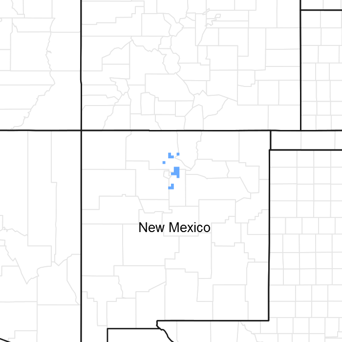
MLRA 36 occurs on the higher elevation portion of the Colorado Plateau. The Colorado Plateau is a physiographic province which exists throughout eastern Utah, western Colorado, western New Mexico and northern Arizona. It is characterized by uplifted plateaus, canyons and eroded features. The Colorado Plateau lies south of the Uintah Mountains, north of the Mogollon transition area, west of the Rocky Mountains, and east of the central Utah highlands. The higher elevation portion of the Colorado Plateau which is represented by MLRA 36 is characterize by broken topography, and lack of perennial water sources. This area has a long history of past prehistoric human use for years. MLRA 36 shows archaeological evidence indicating that pinyon-juniper woodlands where modified by prehistoric humans and not pristine and thus where altered at the time of European settlement (Cartledge & Propper, 1993). This area also included natural influences of herbivory, fire, and climate. This area rarely served as habitat for large herds of native herbivores or large frequent historic fires due to the broken topography. This site is extremely variable and plant community composition will vary with the water fluctuations on this site.
The lower part MLRA 36 developed under climatic conditions that include hot, dry summers with summer rains showers and little to no snow with the mild winter temperatures. This area has climatic fluctuations and prolonged droughts are common occurrences. Between an above average year and a drought year. Forbs are the most dynamic component of this community and can vary up to 4 fold (Passey et.al. 1982). The precipitation and climate of MLRA 36 are conducive to producing Pinyon/juniper, and sagebrush complexes with high productive sites in the bottoms of the canyons. Predominant species on the Colorado Plateau are Wyoming big sagebrush (Artemisia tridentata var. wyomingensis), mountain big sagebrush (A. tridentata var. vaseyana), and black sagebrush (A. nova), basin big sagebrush (A. tridentata var. tridentata), Utah juniper (Juniperus utahensis), one-seed juniper (Juniperus monosperma), and two-needle pinyon (Pinus edulis). One-seed juniper has the capability to discontinue active growth when moisture is limited but can resume growth when moisture availability improves. This growth pattern may represent an important adaptation allowing them to survive on very arid sites. It is possible that small trees may be killed by drought; mature one-seed junipers are resilient to drought, especially in comparison to two-needle pinyon (Johnsen, 1962).
The productivity and composition of this plant community would have been quite stable, although varying with the climate because it would have been affected by runoff from streams originating at higher elevations in adjacent mountains. The water table usually persisted throughout the year, causing poorly-aerated soils. The water table is fed by spring snow melt, groundwater and monsoonal rains. Following very wet winters, the melting snow pack would have caused a high and widespread surge of flooding. Wet meadows are areas where it floods frequently or has a shallow water table with some wetland properties. Wet Meadows are a small portion of the landscape footprint. Less than 1% of the landscape in the southwest are characterized as wetlands and wet meadows is just one of several wetland types that occur (Ramstead, 2012). This site is important part of the landscape as it often serves as habitat for plants, birds and other wildlife.
Wet meadows in the southwest are one of the most altered ecosystem types by humans. They are used for livestock and wildlife grazing, many locations have small dams with ponds or stock tanks. In irrigated meadows, roads are commonly built through or adjacent to them, they are prone to invasive species and can be impacted by wildfires in the surrounding upland areas. (Ramstead et al., 2012)
Meadows with tufted hairgrass as a major component are very sensitive to water table fluctuations. A study in Oregon showed that when the water table is lowered it favored increases in Kentucky bluegrass and perennial forbs in the species composition. While increase in the water table favored sedges and rush establishment. (Walsh, 1995) In the mountain west, Kentucky bluegrass is well adapted to the meadow with seasonally high water tables and midsummer drought. Kentucky bluegrass has become dominated on many meadows which once had a larger component of tufted hairgrass. (Uchytil, 1993)
Records of fire with wet meadows are lower elevations are rare to non-existent. The communities listed do not include wet meadows for fire regimes. In general, Intermountain riparian communities have been found to have a fire interval of 20 to 370 years (USDA, 2012a). While southwestern desert grasslands have a fire interval of 10-833 years (USDA, 2012b). Another source states that meadows have a fire return interval of 30 to 60 years (Landfire, 2007). The second source covers 2 ecological sites. It covers the upper precipitation end of wet meadow, and mountain meadows ecological site from an adjacent MLRA (48A). This site is not described in the fire regime literature that is available at this time. The data available is for general vegetation types in the United States: no specific data for wet meadows on Colorado Plateau is available at this time.
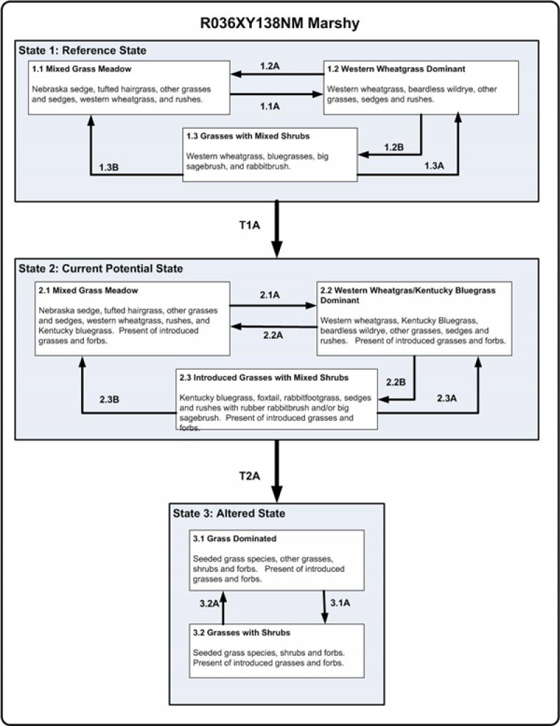
Variability in climate, soils, aspect and complex biological processes will cause the plant communities to differ. These factors contributing to annual production variability include wildlife use, drought, and insects. Factors contributing to special variability include soil texture, depth, rock fragments, slope, aspect, and micro-topography. The species lists are representative and not a complete list of all occurring or potentially occurring species on this site. The species lists are not intended to cover the full range of conditions, species and responses of the site. The State & Transition model depicted for this site is based on available research, field observations and interpretations by experts and could change as knowledge increases. As more data is collected, some of these plant communities may be revised or removed, and new ones may be added. The following diagram does not necessarily depict all the transitions and states that this site may exhibit, but it does show some of the most common plant communities.
On soils having a mesic soil temperature regime, Baltic rush and Nebraska sedge are subordinate to Western Wheatgrass and are aggregated in colonies only in wetter depressions. Orange arnica, silverweed and small bedstraw are typical forbs of more mesic sites. On the drier precipitation range of this site Nevada bluegrass, Beardless wildrye (creeping wildrye), western yarrow and rose pussytoes are subordinate to tufted hairgrass. If the condition of this site deteriorates as a result of overgrazing, Western wheatgrass decreases and becomes co-dominant with other grasses, sedges and forbs. Baltic rush, sedges or reedgrass become more dominant, with large colonies of arnica, and silverweed occurring on the more mesic sites.
With overgrazing on soils having a mesic soil temperature regime, Nebraska sedge is capable of becoming dominant. On the drier precipitation range of this site, prairie junegrass and oatgrass along with yarrow, aster, cinquefoil and buttercups increase. With lowering of the water table Kentucky bluegrass can become naturalized and become co-dominant with mat muhly. Severe stream entrenchment may change the stand composition to upland species such as big sagebrush, grey rabbitbrush and annual weeds. Foxtail barley, squirreltail, lupine, dock and thistle are likely to invade.
This site is used for livestock grazing and wildlife habitat. The historic climax vegetation is rush, sedge, western wheatgrass, bluejoint. Dynamics of the site revolve around available moisture and drainage and deposits of alluvial material and scouring when the intermittent stream moves the channel. These events add or subtract soil and nutrients from the site. They also change the hydrology either adding water, ponding longer or the site drys out resulting in species shifts. The shallow water almost year round makes this a highly productive and resilient site. Most of the communities in this site are in the reference state. A major long term shift in hydrology is needed to change states.
Community 1.1 Mixed Grass Meadow
This community phase vegetation is dominantly rush, sedge, western wheatgrass, and bluejoint. Dynamics of the site revolve around available moisture and drainage and deposits of alluvial material and scouring when the intermittent stream moves the channel. These events add or subtract soil and nutrients from the site. They also change the hydrology either adding water, ponding longer or the site drys out resulting in species shifts. The shallow water almost year round makes this a highly productive and resilient site.
Figure 8. Annual production by plant type (representative values) or group (midpoint values)
Table 5. Annual production by plant type
Plant type
Low (lb/acre)
Representative value (lb/acre)
High (lb/acre)
Grass/Grasslike
900
1200
1500
Forb
100
200
300
Total
1000
1400
1800
Figure 9. Plant community growth curve (percent production by month). NM3638, R036XB138NM Marshy Reference State. R036XB138NM Marshy Reference State.
Jan
Feb
Mar
Apr
May
Jun
Jul
Aug
Sep
Oct
Nov
Dec
J
F
M
A
M
J
J
A
S
O
N
D
0
2
3
4
4
10
20
20
15
8
8
6
Community 1.2 Western Wheatgrass Dominant
This plant community is a result of time without disturbance, mainly from fire, and prolonged drought. As this site deteriorates due to improper grazing tufted hairgrass, oatgrasses, slender wheatgrass and forbs decrease while Kentucky bluegrass, western wheatgrass, rushes, rubber rabbitbrush, and yellow rabbitbrush increase. Foxtail barley, povertyweed, and cheatgrass are most likely to invade this site.
Figure 10. Plant community growth curve (percent production by month). CO0103, MLRA 36 - Foothills Mesic. MLRA 36.
Jan
Feb
Mar
Apr
May
Jun
Jul
Aug
Sep
Oct
Nov
Dec
J
F
M
A
M
J
J
A
S
O
N
D
0
0
8
32
32
18
0
0
4
6
0
0
Community 1.3 Grass and Mixed Shrub
Upland shrubs will increase on this site as it gets drier. Rubber rabbitbrush and big sagebrush may increase, if present near the site. Foxtail may replace wetter species if the grazing pressure is great and there has been a prolonged drought.
Figure 11. Plant community growth curve (percent production by month). CO0103, MLRA 36 - Foothills Mesic. MLRA 36.
Jan
Feb
Mar
Apr
May
Jun
Jul
Aug
Sep
Oct
Nov
Dec
J
F
M
A
M
J
J
A
S
O
N
D
0
0
8
32
32
18
0
0
4
6
0
0
Pathway 1.2A Community 1.2 to 1.1
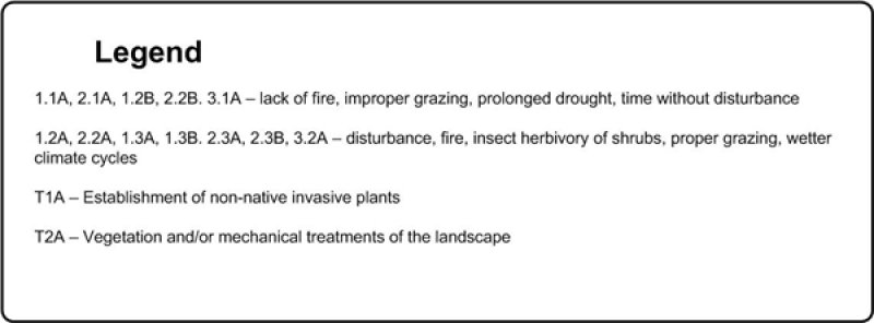
This pathway is caused by naturally occurring fires and/or insect herbivory removes the shrubs. It reverts the system back to a grassland phase. Proper grazing practices which allow for recover of tufted hairgrass, Nebraska sedge, and other grass species will also help this pathway. Also, wetter climatic cycles will help to decrease shrubs as the shrubs that would occur here naturally don’t like to be in areas of standing water for extended periods of time.
Pathway 1.2B Community 1.2 to 1.3
This pathway happens when fire does not occur within the historical fire regime interval for the site. Improper continuous grazing of perennial grasses will speed up this pathway. Improper grazing will cause, foxtail, and rubber rabbitbrush to increase. Also, prolonged drought with decreased water tables will progress along this pathway.
Pathway 1.3B Community 1.3 to 1.1
This pathway is caused by naturally occurring fires and/or insect herbivory removes the shrubs and possible trees if they have encroached on this site. It reverts the system back to a grassland phase. These events tend to favor grass establishment. Also, brush management and proper grazing can benefit this pathway.
State 2 Current Potential
The current potential state is similar in structure and function to the reference state, however invasive and non-natives species are present in all community phases. The current potential state is generally dominated by perennial grasses. Kentucky bluegrass can become a dominant in this plant community. The current potential state is less resilient than the reference state due to the presence of non-native/invasive species in the plant community. Annual herbaceous weedy plants have increased, but occur in small patches. Invasive species present can include knapweeds, Canada thistle, and curly dock.
Community 2.1 Mixed Grass Meadow
This plant community is comprised of tufted hairgrass, sedges, and rushes with few scattered rubber rabbitbrush. Kentucky bluegrass may be found in this phase. Abundance, and production of herbaceous plants and forb production are dependent on the timing of precipitation, and can vary widely between years. Nonnative invasive species, such as thistles, knotweeds, dandelion, and povertyweed are present but in insignificant amounts.
Figure 12. Plant community growth curve (percent production by month). CO0103, MLRA 36 - Foothills Mesic. MLRA 36.
Jan
Feb
Mar
Apr
May
Jun
Jul
Aug
Sep
Oct
Nov
Dec
J
F
M
A
M
J
J
A
S
O
N
D
0
0
8
32
32
18
0
0
4
6
0
0
Community 2.2 Western Wheatgrass and Kentucky Bluegrass Dominant
This plant community is a result of time without disturbance, mainly from fire and prolonged drought. Western wheatgrass and rubber rabbitbrush will have increased in abundance. Nonnative invasive species, such as thistles, knotweeds, dandelion, and povertyweed are present but in insignificant amounts.
Figure 13. Plant community growth curve (percent production by month). CO0103, MLRA 36 - Foothills Mesic. MLRA 36.
Jan
Feb
Mar
Apr
May
Jun
Jul
Aug
Sep
Oct
Nov
Dec
J
F
M
A
M
J
J
A
S
O
N
D
0
0
8
32
32
18
0
0
4
6
0
0
Community 2.3 Introduced Grasses with Mixed Shrubs
Foxtail and Baltic rush dominates the plant community. Also, rubber rabbitbrush has increased. Foxtail may replace the other perennial if the grazing pressure is great and there has been a prolonged drought. Nonnative invasive species, such as thistles, knotweeds, dandelion, and povertyweed are present but in insignificant amounts.
Figure 14. Plant community growth curve (percent production by month). CO0103, MLRA 36 - Foothills Mesic. MLRA 36.
Jan
Feb
Mar
Apr
May
Jun
Jul
Aug
Sep
Oct
Nov
Dec
J
F
M
A
M
J
J
A
S
O
N
D
0
0
8
32
32
18
0
0
4
6
0
0
Pathway 2.2B Community 2.2 to 2.1
This pathway happens when fire does not occur within the historical fire regime interval for the site. Improper continuous grazing of perennial grasses will speed up this pathway. Improper grazing will cause, foxtail, and rubber rabbitbrush to increase. Also, prolonged drought with decreased water tables will progress along this pathway.
State 3 Altered
This state results from seeding introduced perennial grasses. Some of the potential grass found may include the following: meadow foxtail, orchardgrass, meadow barley, timothy and smooth brome. Native perennial grasses, forbs and shrubs may be included in the seed mix. This state behave similar community dynamics to the current potential state community. Other vegetation treatments may be necessary to get to this state, they include mowing, disking, prescribed burning and other techniques which manipulate the plant community. The seeded state could persist for long periods of time with proper management. Native grasses and forbs may reestablish over time from nearby seed sources.
Community 3.1 Grass Dominated
This community is dominated by seeded plants. Shrubs has little to no production in this phase. This site has high production due to the seed grass production. This production typically is higher than the current potential or reference state. This site usually has low species diversity.
Figure 15. Plant community growth curve (percent production by month). CO0103, MLRA 36 - Foothills Mesic. MLRA 36.
Jan
Feb
Mar
Apr
May
Jun
Jul
Aug
Sep
Oct
Nov
Dec
J
F
M
A
M
J
J
A
S
O
N
D
0
0
8
32
32
18
0
0
4
6
0
0
Community 3.2 Grass and Shrub
This community consists shrubs with grasses. Nonnative invasive species, such as thistles, knotweeds, dandelion, and povertyweed are present but in insignificant amounts.
Figure 16. Plant community growth curve (percent production by month). CO0103, MLRA 36 - Foothills Mesic. MLRA 36.
Jan
Feb
Mar
Apr
May
Jun
Jul
Aug
Sep
Oct
Nov
Dec
J
F
M
A
M
J
J
A
S
O
N
D
0
0
8
32
32
18
0
0
4
6
0
0
Transition T2A State 2 to 3
This transition is triggered by management decisions and actions. This transition, to a state that has been seeded with introduced perennial grasses. High energy inputs are needed for this transition. Brush will need to be removed with vegetation treatment techniques (I.e. chemical, mechanical, or fire) and introduced species that are adapted to the area and adapted to management needs have been seeded and become established. Water diversion maybe used to enhance or alter this site hydrological regime.
Additional community tables
Table 6. Community 1.1 plant community composition
Highly productive site providing feed and habitat to livestock and wildlife.
Hydrological functions
Located adjacent to abandoned channels on flood plains of valley floors with intermittent streams. Very poorly drained; high surface runoff; moderate and moderately rapid permeability in the upper part of the profile and rapid and very rapid permeability in the lower part of the profile. These soils are subject to occasional, extremely brief periods of flooding between July and September. Floodwaters have low velocity and are generally less than 1 foot deep. A seasonal high water table is present between the soil surface and 1.0 foot.
Recreational uses
Bird watching would be particularly productive on this site.
Wood products
No known wood products.
Supporting information
Inventory data references
TYPE LOCATION: Santa Fe County, New Mexico; on the Tesuque Indian Reservation about 0.25 mile west-southwest of Camel Rock; USGS Tesuque 7.5 minute topographic quadrangle; 900 feet west and 1,350 feet south of the northeast corner of section 4, T.18N., R.9E.; Latitude 35 degrees 49 minutes 23 seconds North and Longitude 105 degrees 59 minutes 5 seconds West, NAD 27.
Other references
Cartledge, T. R., and J. G. Propper. 1993. Pinon-Juniper Ecosystems through Time: Information and Insights from the Past. In Gen. Tech. RM-236 - Managing Pinon-Juniper Ecosystems for Sustainability and Social Needs.
Cleland, D.T.; Freeouf, J.A.; Keys, J.E., Jr.; Nowacki, G.J.; Carpenter, C; McNab, W.H. 2007. Ecological Subregions: Sections and Subsections of the Conterminous United States.[1:3,500,000], Sloan, A.M., cartog. Gen. Tech. Report WO-76. Washington, DC: U.S. Department of Agriculture, Forest Service.
Griffith, G.E.; Omernik, J.M.; McGraw, M.M.; Jacobi, G.Z.; Canavan, C.M.; Schrader, T.S.; Mercer, D.; Hill, R.; and Moran, B.C., 2006. Ecoregions of New Mexico (color poster with map, descriptive text, summary tables, and photographs): Reston, Virginia, U.S. Geological Survey (map scale 1:1,400,000).
LANDFIRE: LANDFIRE National Vegetation Dynamics Models. (2007, January - last update). [Homepage of the LANDFIRE Project, U.S. Department of Agriculture, Forest Service; U.S. Department of Interior], [Online]. [2017, August 8]. Landfire Biophysical Setting Model 2311640: Page 218-223.
Natural Resources Conservation Service (NRCS). 2003. Ecological Site Description for Meadow R036XB008NM: USDA, Albuquerque. New Mexico.
Passey, H. B., W. K. Hugie, E. W. Williams, and D. E. Ball. 1982. Relationships between soil, plant community, and climate on rangelands of the Intermountain west. USDA, Soil Conservation Service, Tech. Bull. No. 1669.
Ramstead, K. M., J. A. Allen and A. E. Springer. 2012. Have wet meadow restoration projects in the Southwestern U.S. been effective in restoring geomorphology, hydrology, soils and plant species composition? Environmental Evidence 2012, 1:11.
Soil Survey Staff, Natural Resources Conservation Service, United States Department of Agriculture. Web Soil Survey. Available online at http://websoilsurvey.nrcs.usda.gov/. Accessed [8/8/2017].
Uchytil, Ronald J. 1993. Poa pratensis. In: Fire Effects Information System, [Online]. U.S. Department of Agriculture, Forest Service, Rocky Mountain Research Station, Fire Sciences Laboratory (Producer). Available: http://www.fs.fed.us/database/feis/ [2017, August 17].
USDA, Forest Service, Missoula Fire Sciences Laboratory. 2012a. Information from LANDFIRE on fire regimes of Intermountain riparian communities. In: Fire Effects Information System, [Online]. U.S. Department of Agriculture, Forest Service, Rocky Mountain Research Station, Missoula Fire Sciences Laboratory (Producer). Available: https://www.fs.fed.us/database/feis/fire_regimes/Intermountain_riparian/all.html [2017, August 21].
USDA, Forest Service, Missoula Fire Sciences Laboratory. 2012b. Information from LANDFIRE on fire regimes of southwestern desert grasslands. In: Fire Effects Information System, [Online]. U.S. Department of Agriculture, Forest Service, Rocky Mountain Research Station, Missoula Fire Sciences Laboratory (Producer). Available: https://www.fs.fed.us/database/feis/fire_regimes/SW_desert_grass/all.html [2017, August 21].
Walsh, Roberta A. 1995. Deschampsia cespitosa. In: Fire Effects Information System, [Online]. U.S. Department of Agriculture, Forest Service, Rocky Mountain Research Station, Fire Sciences Laboratory (Producer). Available: http://www.fs.fed.us/database/feis/ [2017, August 17].
United States Department of Agriculture, Natural Resources Conservation Service. 2006. Land Resource Regions and Major Land Resource Areas of the United States, the Caribbean, and the Pacific Basin. U.S. Department of Agriculture Handbook 296.
Christine Bishop John Tunberg Suzanne Mayne Kinney
Approval
Kirt Walstad, 1/16/2025
Acknowledgments
Project Staff:
Suzanne Mayne-Kinney, Ecological Site Specialist, NRCS MLRA, Grand Junction Colorado SSO
Chuck Peacock, MLRA Soil Survey Leader, NRCS MLRA Grand Junction Colorado SSO
Alan Stuebe, MLRA Soil Survey Leader, NRCS MLRA Alamosa Colorado SSO Program Support:
Brenda Simpson, NRCS NM State Rangeland Management Specialist, Albuquerque, NM
Scott Woodhall, NRCS MLRA Ecological Site Specialist-QA Phoenix, AZ
Eva Muller, Regional Director, Rocky Mountain Regional Soil Survey Office, Bozeman, MT
Rick Strait, NM State Soil Scientist, Albuquerque, NM
Steve Kadas, CO State Resource Conservationist, Albuquerque, NM
--Site Development and Testing Plan--:
Future work to validate and further refine the information in this Provisional Ecological Site Description is necessary. This will include field activities to collect low-, medium-, and high-intensity sampling, soil correlations, and analysis of that data.
Additional information and data is required to refine the Plant Production and Annual Production tables for this ecological site. The extent of MLRA 36 must be further investigated.
Field testing of the information contained in this Provisional ESD is required. As this ESD is moved to the Approved ESD level, reviews from the technical team, quality control, quality assurance, and peers will be conducted.
Rangeland health reference sheet
Interpreting Indicators of Rangeland Health is a qualitative assessment protocol used to
determine ecosystem condition based on benchmark characteristics described in the Reference Sheet. A suite of 17 (or
more) indicators are typically considered in an assessment. The ecological site(s) representative of an assessment
location must be known prior to applying the protocol and must be verified based on soils and climate. Current plant
community cannot be used to identify the ecological site.
Author(s)/participant(s)
Contact for lead author
Date
01/16/2025
Approved by
Kirt Walstad
Approval date
Composition (Indicators 10 and 12) based on
Annual Production
Indicators
Number and extent of rills:
Presence of water flow patterns:
Number and height of erosional pedestals or terracettes:
Bare ground from Ecological Site Description or other studies (rock, litter, lichen, moss, plant canopy are
not bare ground):
Number of gullies and erosion associated with gullies:
Extent of wind scoured, blowouts and/or depositional areas:
Amount of litter movement (describe size and distance expected to travel):
Soil surface (top few mm) resistance to erosion (stability values are averages - most sites will show a range
of values):
Soil surface structure and SOM content (include type of structure and A-horizon color and thickness):
Effect of community phase composition (relative proportion of different functional groups) and spatial
distribution on infiltration and runoff:
Presence and thickness of compaction layer (usually none; describe soil profile features which may be
mistaken for compaction on this site):
Functional/Structural Groups (list in order of descending dominance by above-ground annual-production or live foliar
cover using symbols: >>, >, = to indicate much greater than, greater than, and equal to):
Dominant:
Sub-dominant:
Other:
Additional:
Amount of plant mortality and decadence (include which functional groups are expected to show mortality or
decadence):
Average percent litter cover (%) and depth ( in):
Expected annual annual-production (this is TOTAL above-ground annual-production, not just forage annual-production):
Potential invasive (including noxious) species (native and non-native). List species which BOTH characterize
degraded states and have the potential to become a dominant or co-dominant species on the ecological site if
their future establishment and growth is not actively controlled by management interventions. Species that become
dominant for only one to several years (e.g., short-term response to drought or wildfire) are not invasive
plants. Note that unlike other indicators, we are describing what is NOT expected in the reference state for the
ecological site:
The Ecosystem Dynamics Interpretive Tool is an information system framework developed by the USDA-ARS Jornada Experimental Range, USDA Natural Resources Conservation Service, and New Mexico State University.
Click on box and path labels to scroll to the respective text.