
Natural Resources
Conservation Service
Ecological site R041XC318AZ
Sandy Loam 12-16" p.z. Deep
Last updated: 7/21/2020
Accessed: 02/06/2026
General information
Provisional. A provisional ecological site description has undergone quality control and quality assurance review. It contains a working state and transition model and enough information to identify the ecological site.
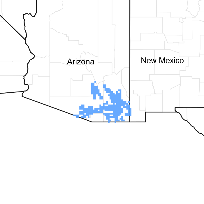
Figure 1. Mapped extent
Areas shown in blue indicate the maximum mapped extent of this ecological site. Other ecological sites likely occur within the highlighted areas. It is also possible for this ecological site to occur outside of highlighted areas if detailed soil survey has not been completed or recently updated.
MLRA notes
Major Land Resource Area (MLRA): 041X–Madrean Archipelago
AZ 41.3 – Chihuahuan – Sonoran Semidesert Grasslands
Elevations range from 3200 to 5000 feet and precipitation ranges from 12 to 16 inches per year. Vegetation includes mesquite, catclaw acacia, netleaf hackberry, palo verde, false mesquite, range ratany, fourwing saltbush, tarbush, littleleaf sumac, sideoats grama, black grama, plains lovegrass, cane beardgrass, tobosa, vine mesquite, threeawns, Arizona cottontop and bush muhly. The soil temperature regime is thermic and the soil moisture regime is ustic aridic. This unit occurs within the Basin and Range Physiographic Province and is characterized by numerous mountain ranges that rise abruptly from broad, plain-like valleys and basins. Igneous and metamorphic rock classes dominate the mountain ranges and sediments filling the basins represent combinations of fluvial, lacustrine, colluvial and alluvial deposits.
Associated sites
| R041XC306AZ |
Shallow Hills 12-16" p.z. |
|---|---|
| R041XC319AZ |
Sandy Loam Upland 12-16" p.z. |
| R041XC322AZ |
Shallow Upland 12-16" p.z. |
Similar sites
| R040XA117AZ |
Sandy Loam Upland, Deep 10"-13" p.z. |
|---|---|
| R041XA110AZ |
Sandy Loam Upland 16-20" p.z. |
Table 1. Dominant plant species
| Tree |
Not specified |
|---|---|
| Shrub |
(1) eriogonum wrightii |
| Herbaceous |
(1) bouteloua curtipendula |
Physiographic features
This site occurs in the middle elevations of the Madrean Basin and Range province in southeastern Arizona. This site occurs on fan terraces and stream terraces. It is always in an upland position. Slopes are mainly 1-3%, but may range as high as 8%.
Table 2. Representative physiographic features
| Landforms |
(1)
Terrace
(2) Fan piedmont (3) Plain |
|---|---|
| Flooding frequency | None |
| Ponding frequency | None |
| Elevation | 3,300 – 5,000 ft |
| Slope | 1 – 8% |
| Aspect | Aspect is not a significant factor |
Climatic features
Precipitation in this common resource area ranges from 12-16 inches yearly in the eastern part with elevations from 3600-5000 feet, and 13-17 inches in the western part where elevations are 3300-4500 feet. Winter-Summer rainfall ratios are 40-60% in the west and 30-70% in the east. Summer rains fall July-September, originate in the Gulf of Mexico and are convective, usually brief, intense thunderstorms. Cool season moisture tends to be frontal, originates in the Pacific and Gulf of California, and falls in widespread storms with long duration and low intensity. Snow rarely lasts more than one day. May and June are the driest months of the year. Humidity is generally very low.
Temperatures are mild. Freezing temperatures are common at night from December-April; however temperatures during the day are frequently above 50 F. Occasionally in December-February, brief 0 F temperatures may be experienced some nights. During June, July and August, some days may exceed 100 F.
Cool season plants start growth in early spring and mature in early summer. Warm season plants take advantage of summer rains and are growing and nutritious July-September. Warm season grasses may remain green throughout the year.
Table 3. Representative climatic features
| Frost-free period (average) | 220 days |
|---|---|
| Freeze-free period (average) | |
| Precipitation total (average) | 16 in |
Figure 2. Monthly precipitation range
Figure 3. Monthly average minimum and maximum temperature
Influencing water features
There are no water features associated with this site.
Soil features
These are deep soils which have formed in recent sandy alluvium, usually, of granitic origin. They are sandy loam throughout at least to moderate depths (40 inches). Surface textures range from loamy sand to gravelly sandyloam. Soil surfaces are thick and dark colored. Plant-soil moisture relationships are good.
Soil series mapped on this site include: SSA-661 Eastern Pinal & Southern Gila counties MU's 21 Mallet, 23 & 71 Combate; SSA-664 San Simon area MU 12 Comoro; SSA-665 Willcox area MU's CmA, CnA & CnC Comoro, Cs Cowan, SnA, SnB & SoA Sonoita; SSA-666 Cochise county Northwest part MU's 25 & 26 Combate, 38 Durazo, 59 Mallet & Hooks; SSA-667 Santa Cruz area MU's An Anthony and Ao Anthony GrV; SSA-669 Pima county Eastern part MU's 18 Combate and 37 Keesto; SSA-671 Cochise county Douglas-Tombstone part MU's 1 Altar & Mallet, 5 Combate, 32 Combate LS, 105 Mallet, 112 Ruins thick surface, 120 Perilla, 137 Swisshelm SL and 138 Swisshelm SL saline-sodic; SSA-703 Tohono O'odham Nation MU's 5 & 14 Combate.
Table 4. Representative soil features
| Parent material |
(1)
Alluvium
–
granite
|
|---|---|
| Surface texture |
(1) Loamy sand (2) Sandy loam (3) Gravelly sandy loam |
| Family particle size |
(1) Loamy |
| Drainage class | Well drained |
| Permeability class | Moderately rapid to rapid |
| Soil depth | 40 – 60 in |
| Surface fragment cover <=3" | 1 – 20% |
| Surface fragment cover >3" | 2% |
| Available water capacity (0-40in) |
4.8 – 7.8 in |
| Calcium carbonate equivalent (0-40in) |
5% |
| Electrical conductivity (0-40in) |
2 mmhos/cm |
| Sodium adsorption ratio (0-40in) |
2 |
| Soil reaction (1:1 water) (0-40in) |
6.6 – 8.4 |
| Subsurface fragment volume <=3" (Depth not specified) |
2 – 20% |
| Subsurface fragment volume >3" (Depth not specified) |
2% |
Ecological dynamics
The plant communities found on an ecological site are naturally variable. Composition and production will vary with yearly conditions, location, aspect, and the natural variability of the soils. The Historical Climax Plant Community represents the natural potential plant communities found on relict or relatively undisturbed sites. Other plant communities described here represent plant communities that are known to occur when the site is disturbed by factors such as fire, grazing, or drought.
Production data provided in this site description is standardized to air dry weight at the end of the summer growing season. The plant communities described in this site description are based on near normal rainfall years.
NRCS uses a Similarity Index to compare existing plant communities to the plant communities described here. Similarity index is determined by comparing the production and composition of a plant community to the production of a plant community described in this site description. To determine Similarity Index, compare the production (air dry weight) of each species to that shown in the plant community description. For each species, count no more than the maximum amount shown for the species, and for each group, count no more than the maximum amount shown for the group. Divide the resulting total by the total normal year production shown in the plant community description. If rainfall has been significantly above or below normal, use the total production shown for above or below normal years. If field data is not collected at the end of the summer growing season, then the field data must be corrected to the end of the year production before comparing it to the site description. The growth curve can be used as a guide for estimating production at the end of the summer growing season.
State and transition model
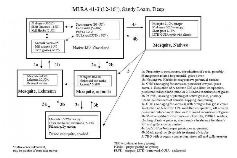
More interactive model formats are also available.
View Interactive Models
More interactive model formats are also available.
View Interactive Models
Click on state and transition labels to scroll to the respective text
Ecosystem states
States 2 and 5 (additional transitions)
State 1 submodel, plant communities
State 2 submodel, plant communities
State 3 submodel, plant communities
State 4 submodel, plant communities
State 5 submodel, plant communities
State 1
Historic Climax Plant Community
Community 1.1
Historic Climax Plant Community

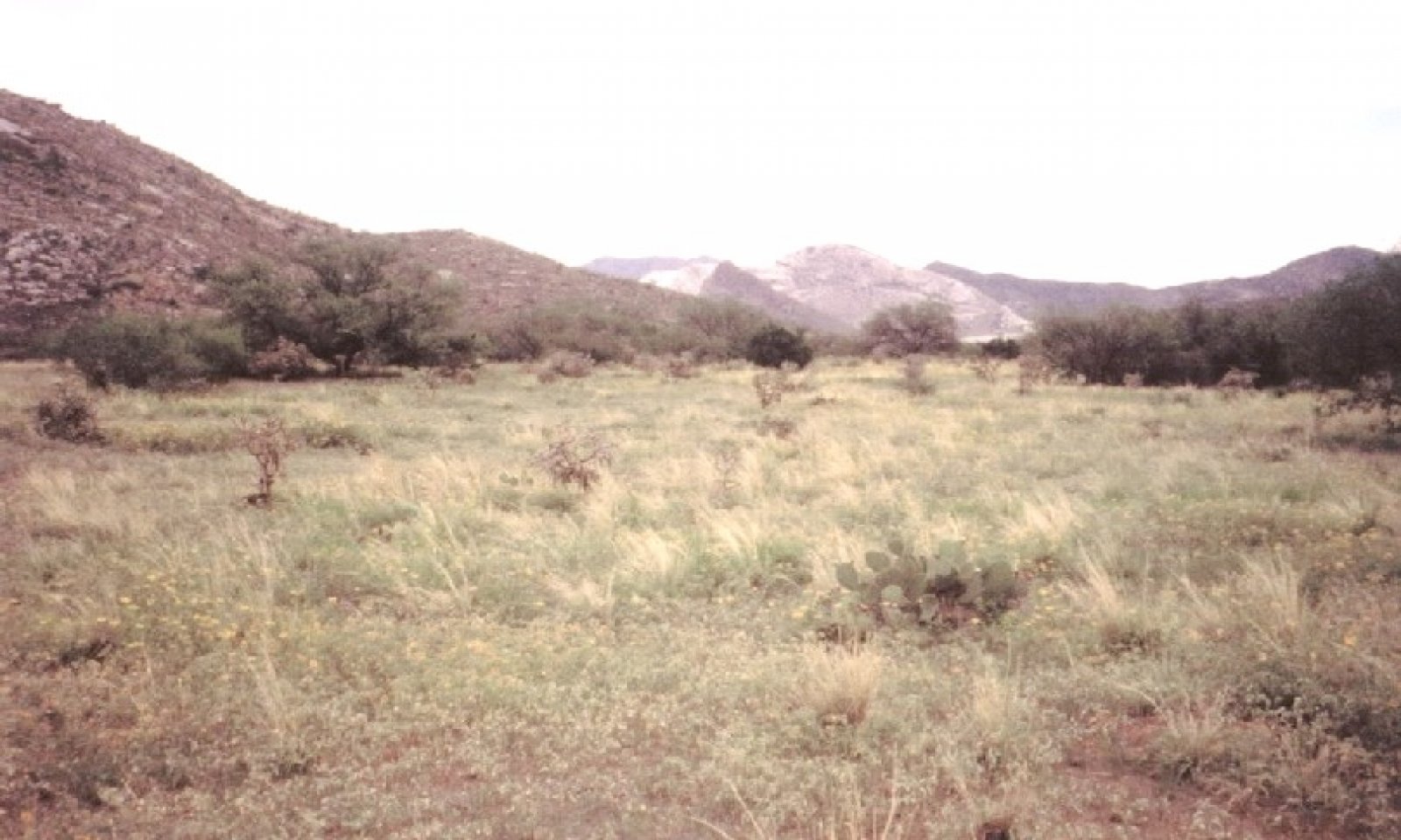
Figure 4. Sandy Loam Deep 12-16" pz.
The potential plant community on this site is dominated by warm season perennial grasses. The major perennial grass species on the site tend to be well dispersed throughout the plant community. Several species of half-shrubs are well represented in the plant community. The aspect is grassland with occasional clumps of desert hackberry, catclaw acacia or mesquite. With continuous heavy grazing, palatable perennial grasses are removed from the potential plant community and species such as Rothrock grama, mesa threeawn, and spidergrass increase. In areas where burroweed dominates the plant community the potential production of perennial mid-grasses is equal to the present production of burroweed once it is removed from the plant community. Even with low plant cover, these soils produce very little runoff and have very low erosion rates. Some soils are sandy textured but have enough coarse fragments that they are not subject to wind erosion. Naturally occurring wildfires (June through August) were important in the development of the potential plant community, and helped maintain a grassland aspect. Hydrologic relationships are good with very little runoff in most years due to coarse textured soils, high plant and litter cover and low soil bulk densities.
Figure 5. Annual production by plant type (representative values) or group (midpoint values)
Table 5. Annual production by plant type
| Plant type | Low (lb/acre) |
Representative value (lb/acre) |
High (lb/acre) |
|---|---|---|---|
| Grass/Grasslike | 435 | 850 | 1330 |
| Shrub/Vine | 56 | 100 | 260 |
| Forb | 30 | 50 | 250 |
| Tree | 0 | 5 | 15 |
| Total | 521 | 1005 | 1855 |
Table 6. Soil surface cover
| Tree basal cover | 0-1% |
|---|---|
| Shrub/vine/liana basal cover | 0-1% |
| Grass/grasslike basal cover | 6-15% |
| Forb basal cover | 0-1% |
| Non-vascular plants | 0-1% |
| Biological crusts | 0-5% |
| Litter | 30-75% |
| Surface fragments >0.25" and <=3" | 5-20% |
| Surface fragments >3" | 0-2% |
| Bedrock | 0% |
| Water | 0% |
| Bare ground | 10-25% |
Table 7. Canopy structure (% cover)
| Height Above Ground (ft) | Tree | Shrub/Vine | Grass/ Grasslike |
Forb |
|---|---|---|---|---|
| <0.5 | – | 0-5% | 0-10% | 0-5% |
| >0.5 <= 1 | – | 2-10% | 10-20% | 1-5% |
| >1 <= 2 | – | 0-10% | 20-40% | 0-5% |
| >2 <= 4.5 | – | 0-1% | 0-10% | – |
| >4.5 <= 13 | 0-1% | 0-1% | – | – |
| >13 <= 40 | – | – | – | – |
| >40 <= 80 | – | – | – | – |
| >80 <= 120 | – | – | – | – |
| >120 | – | – | – | – |
Figure 6. Plant community growth curve (percent production by month). AZ4134, 41.3 12-16" p.z. other sites. Growth begins in the spring, semi-dormancy occurs during the May through June drought, most growth occurs during the summer rains..
| Jan | Feb | Mar | Apr | May | Jun | Jul | Aug | Sep | Oct | Nov | Dec |
|---|---|---|---|---|---|---|---|---|---|---|---|
| J | F | M | A | M | J | J | A | S | O | N | D |
| 0 | 0 | 5 | 10 | 0 | 0 | 30 | 35 | 15 | 5 | 0 | 0 |
State 2
Mesquite, native grass
Community 2.1
Mesquite, native grass
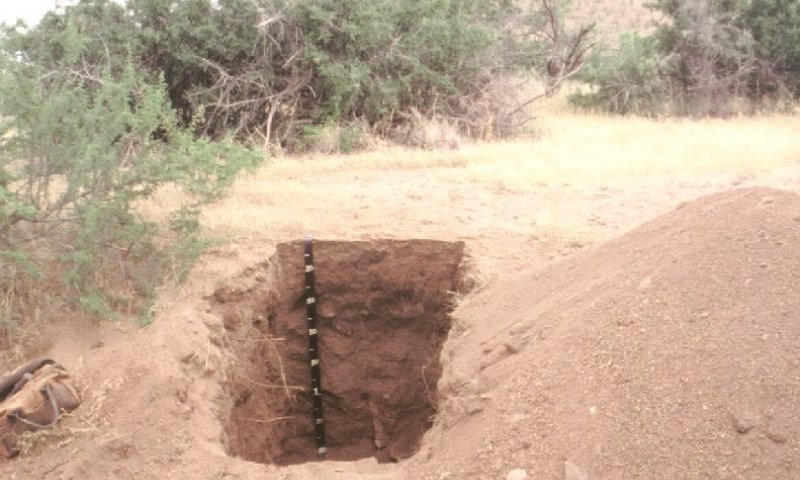
Figure 7. Sandy Loam Deep 12-16" pz. Combate soils
Mesquite increases in the absence of fire for long periods of time. Native perennial grasses maintain dominance, with good grazing management, and mesquite canopy levels up to 10%. Burroweed fluctuates in the plant community with climate, but never becomes dominant. Cholla and prickly pear can cycle through the plant community. Some soil compaction has occurred due to livestock traffic, but hydrologic relationships have not been impaired.
State 3
Mesquite, annual grass and forb state
Community 3.1
Mesquite, annual grass and forb state
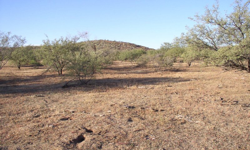
Figure 8. Sandy Loam Deep 12-16" pz. mesquite, annuals
Mesquite is dominant with canopy levels of 10 to 15%. Native and non-native annual forbs and grasses, both cool and warm season, dominate the under-story. Burroweed and snakeweed cycle with climate, but are always important in the under-story. Native perennial grasses are gone due to the interactions of drought, fire and continuous heavy grazing. Usually, soil compaction and the loss of herbaceous cover have resulted in sheet, rill and gully erosion on the site. Hydrologic relationships have changed to increase the amount of runoff.
State 4
Mesquite, Lehmann lovegrass
Community 4.1
Mesquite, Lehmann lovegrass
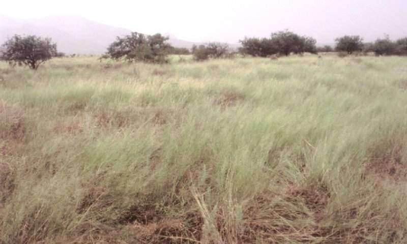
Figure 9. Sandy Loam Deep 12-16" pz. Lehmann invasion
Mesquite has increased in the absence of fires for long periods of time to canopy levels of 10%. Lehmann lovegrass has invaded from seeded areas and is dominant in the under-story. Remnant native perennial grasses diminish over time. Native annual forbs and grasses diminish in the soil seed-bank over time. Fire may act to increase dominance of lehmann lovegrass at the expense of native perennial grasses, but may allow native annual species a chance to make seed and persist in the seed-bank. Some soil compaction has occurred due to livestock traffic, but hydrologic relationships have not been impaired.
State 5
Dense mesquite and other shrubs, succulents
Community 5.1
Dense mesquite and other shrubs, succulents
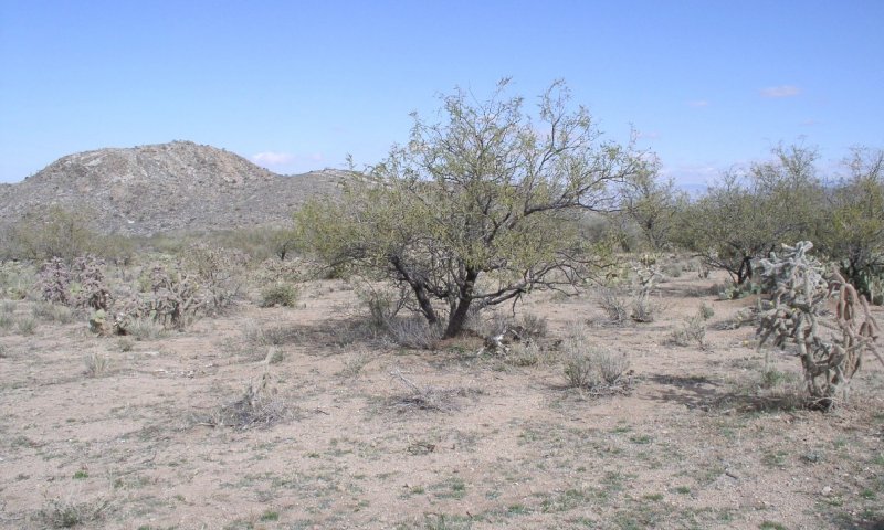
Figure 10. Sandy Loam Deep 12-16" pz. dense mesquite, eroded
Mesquite continues to increase in the absence of fire up to canopy levels of 25%. Other shrubs and succulents like prickly pear and cholla, dominate the under-story. Remnant perennial grasses exist only in the protection of cacti and shrubs. Occasional fires may burn after extremely wet seasons, but mesquite is well established and sprouts back to a thorn-scrub stage. Soil compaction and reduced herbaceous cover has resulted in sheet, rill and gully erosion on the site. Hydrologic relationships have been impaired and runoff is increased.
Transition T1A
State 1 to 2
Lack of fire but proper grazing or no grazing
Transition T1B
State 1 to 3
Continuous Heavy Grazing (managing for annuals), persistent low perennial grass cover.
Transition T1C
State 1 to 4
Proximity to seed source, introduction of seeds, possibly management related to perennial grass cover.
Restoration pathway R2A
State 2 to 1
Brush management, prescribed grazing
Transition T2A
State 2 to 3
Continuous Heavy Grazing with drought, compaction, sheet, rill and gully erosion
Transition T2B
State 2 to 5
Continuous Heavy Grazing with drought, compaction, sheet, rill and gully erosion
Restoration pathway R3A
State 3 to 1
Prescribed Grazing/No Grazing, seeding or planting of native grasses, possibly herbicide treatment of annuals, brush management, mechanical land treatment. Transition to State 4 most likely result.
Restoration pathway R3B
State 3 to 4
Prescribed Grazing/No Grazing, with or without seeding non-native grasses, possibly herbicide treatment of annuals, brush management, mechanical land treatment.
Transition T3A
State 3 to 5
Continuous Heavy Grazing (managing for annuals) with drought, low grass cover
Restoration pathway R1A
State 4 to 1
None known
Transition T4A
State 4 to 5
Continuous Heavy Grazing (managing for annuals) with drought, low grass cover
Restoration pathway R5A
State 5 to 3
Brush management, range seeding, rill and gully erosion control, Prescribed Grazing/No Grazing. Transition to State 4 (restoration pathway R5B) is likely outcome due to prevalence of non-native perennial seedbank throughout the LRU.
Restoration pathway R5B
State 5 to 4
Brush management, range seeding, rill and gully erosion control, Prescribed Grazing/No Grazing.
Additional community tables
Table 8. Community 1.1 plant community composition
| Group | Common name | Symbol | Scientific name | Annual production (lb/acre) | Foliar cover (%) | |
|---|---|---|---|---|---|---|
|
Grass/Grasslike
|
||||||
| 1 | dominant mid-grasses | 200–450 | ||||
| sideoats grama | BOCU | Bouteloua curtipendula | 100–350 | – | ||
| Arizona cottontop | DICA8 | Digitaria californica | 100–350 | – | ||
| spike dropseed | SPCO4 | Sporobolus contractus | 50–150 | – | ||
| 2 | subdom mid-grasses | 50–200 | ||||
| cane bluestem | BOBA3 | Bothriochloa barbinodis | 20–100 | – | ||
| tanglehead | HECO10 | Heteropogon contortus | 25–100 | – | ||
| green sprangletop | LEDU | Leptochloa dubia | 0–100 | – | ||
| plains bristlegrass | SEVU2 | Setaria vulpiseta | 5–50 | – | ||
| 3 | suffrutescent grasses | 110–230 | ||||
| black grama | BOER4 | Bouteloua eriopoda | 50–130 | – | ||
| bush muhly | MUPO2 | Muhlenbergia porteri | 50–130 | – | ||
| Santa Rita threeawn | ARCAG | Aristida californica var. glabrata | 10–100 | – | ||
| 4 | short lived grasses | 35–150 | ||||
| Rothrock's grama | BORO2 | Bouteloua rothrockii | 10–150 | – | ||
| slender grama | BORE2 | Bouteloua repens | 25–100 | – | ||
| 5 | miscellaneous perennial grasses | 10–100 | ||||
| sand dropseed | SPCR | Sporobolus cryptandrus | 5–80 | – | ||
| mesa dropseed | SPFL2 | Sporobolus flexuosus | 0–50 | – | ||
| plains lovegrass | ERIN | Eragrostis intermedia | 0–40 | – | ||
| whiplash pappusgrass | PAVA2 | Pappophorum vaginatum | 0–40 | – | ||
| fall witchgrass | DICO6 | Digitaria cognata | 0–25 | – | ||
| squirreltail | ELELE | Elymus elymoides ssp. elymoides | 5–25 | – | ||
| blue grama | BOGR2 | Bouteloua gracilis | 0–25 | – | ||
| hairy grama | BOHI2 | Bouteloua hirsuta | 0–20 | – | ||
| slim tridens | TRMU | Tridens muticus | 0–20 | – | ||
| common wolfstail | LYPH | Lycurus phleoides | 0–15 | – | ||
| Arizona muhly | MUAR3 | Muhlenbergia arizonica | 0–15 | – | ||
| Hall's panicgrass | PAHA | Panicum hallii | 0–15 | – | ||
| nineawn pappusgrass | ENDE | Enneapogon desvauxii | 0–10 | – | ||
| curly-mesquite | HIBE | Hilaria belangeri | 0–5 | – | ||
| low woollygrass | DAPU7 | Dasyochloa pulchella | 0–5 | – | ||
| 6 | perennial threeawns | 10–80 | ||||
| spidergrass | ARTE3 | Aristida ternipes | 10–50 | – | ||
| spidergrass | ARTEG | Aristida ternipes var. gentilis | 0–25 | – | ||
| Parish's threeawn | ARPUP5 | Aristida purpurea var. parishii | 0–25 | – | ||
| Orcutt's threeawn | ARSCO | Aristida schiedeana var. orcuttiana | 0–10 | – | ||
| purple threeawn | ARPU9 | Aristida purpurea | 0–10 | – | ||
| Fendler threeawn | ARPUL | Aristida purpurea var. longiseta | 0–5 | – | ||
| blue threeawn | ARPUN | Aristida purpurea var. nealleyi | 0–5 | – | ||
| poverty threeawn | ARDI5 | Aristida divaricata | 0–5 | – | ||
| Havard's threeawn | ARHA3 | Aristida havardii | 0–5 | – | ||
| Wooton's threeawn | ARPA9 | Aristida pansa | 0–5 | – | ||
| 7 | annual grasses | 10–150 | ||||
| Parry's grama | BOPA2 | Bouteloua parryi | 0–75 | – | ||
| prairie threeawn | AROL | Aristida oligantha | 0–50 | – | ||
| needle grama | BOAR | Bouteloua aristidoides | 0–50 | – | ||
| Mexican panicgrass | PAHI5 | Panicum hirticaule | 0–50 | – | ||
| Arizona signalgrass | URAR | Urochloa arizonica | 0–50 | – | ||
| sixweeks fescue | VUOC | Vulpia octoflora | 0–50 | – | ||
| tapertip cupgrass | ERACA | Eriochloa acuminata var. acuminata | 0–50 | – | ||
| canyon cupgrass | ERLE7 | Eriochloa lemmonii | 0–25 | – | ||
| desert lovegrass | ERPEM | Eragrostis pectinacea var. miserrima | 0–25 | – | ||
| tufted lovegrass | ERPEP2 | Eragrostis pectinacea var. pectinacea | 0–25 | – | ||
| sixweeks threeawn | ARAD | Aristida adscensionis | 0–25 | – | ||
| Bigelow's bluegrass | POBI | Poa bigelovii | 0–25 | – | ||
| feather fingergrass | CHVI4 | Chloris virgata | 0–25 | – | ||
| sixweeks grama | BOBA2 | Bouteloua barbata | 0–25 | – | ||
| Mexican sprangletop | LEFUU | Leptochloa fusca ssp. uninervia | 0–20 | – | ||
| mucronate sprangeltop | LEPAB | Leptochloa panicea ssp. brachiata | 0–20 | – | ||
| witchgrass | PACA6 | Panicum capillare | 0–20 | – | ||
| Arizona brome | BRAR4 | Bromus arizonicus | 0–15 | – | ||
| delicate muhly | MUFR | Muhlenbergia fragilis | 0–10 | – | ||
| littleseed muhly | MUMI | Muhlenbergia microsperma | 0–10 | – | ||
|
Forb
|
||||||
| 8 | perennial forbs | 20–100 | ||||
| weakleaf bur ragweed | AMCO3 | Ambrosia confertiflora | 1–25 | – | ||
| desert marigold | BAMU | Baileya multiradiata | 1–25 | – | ||
| fingerleaf gourd | CUDI | Cucurbita digitata | 0–25 | – | ||
| coyote gourd | CUPA | Cucurbita palmata | 0–25 | – | ||
| scarlet spiderling | BOCO | Boerhavia coccinea | 1–25 | – | ||
| Arizona foldwing | DIRE4 | Dicliptera resupinata | 0–25 | – | ||
| spreading fleabane | ERDI4 | Erigeron divergens | 0–25 | – | ||
| wild dwarf morning-glory | EVAR | Evolvulus arizonicus | 1–25 | – | ||
| southwestern mock vervain | GLGO | Glandularia gooddingii | 0–25 | – | ||
| Wright's deervetch | LOWR | Lotus wrightii | 0–25 | – | ||
| lacy tansyaster | MAPI | Machaeranthera pinnatifida | 0–25 | – | ||
| canaigre dock | RUHY | Rumex hymenosepalus | 1–25 | – | ||
| desert globemallow | SPAM2 | Sphaeralcea ambigua | 0–25 | – | ||
| brownplume wirelettuce | STPA4 | Stephanomeria pauciflora | 1–25 | – | ||
| hairy fournwort | TENE | Tetramerium nervosum | 0–25 | – | ||
| New Mexico fanpetals | SINE | Sida neomexicana | 0–20 | – | ||
| Wright's cudweed | PSCAC2 | Pseudognaphalium canescens ssp. canescens | 0–20 | – | ||
| New Mexico silverbush | ARNE2 | Argythamnia neomexicana | 0–20 | – | ||
| Watson's dutchman's pipe | ARWA | Aristolochia watsonii | 0–15 | – | ||
| trailing windmills | ALIN | Allionia incarnata | 0–15 | – | ||
| Arizona wrightwort | CAAR7 | Carlowrightia arizonica | 0–15 | – | ||
| Greene's bird's-foot trefoil | LOGR4 | Lotus greenei | 0–10 | – | ||
| slender poreleaf | POGR5 | Porophyllum gracile | 0–5 | – | ||
| Lemmon's ragwort | SELE8 | Senecio lemmonii | 0–5 | – | ||
| Rocky Mountain zinnia | ZIGR | Zinnia grandiflora | 0–5 | – | ||
| Cooley's bundleflower | DECO2 | Desmanthus cooleyi | 0–5 | – | ||
| brownfoot | ACWR5 | Acourtia wrightii | 0–5 | – | ||
| variableleaf bushbean | MAGI2 | Macroptilium gibbosifolium | 0–5 | – | ||
| tufted evening primrose | OECA10 | Oenothera caespitosa | 0–5 | – | ||
| slimleaf bean | PHAN3 | Phaseolus angustissimus | 0–5 | – | ||
| orange fameflower | PHAU13 | Phemeranthus aurantiacus | 0–5 | – | ||
| whitemouth dayflower | COER | Commelina erecta | 0–5 | – | ||
| bluedicks | DICA14 | Dichelostemma capitatum | 0–2 | – | ||
| climbing wartclub | BOSC | Boerhavia scandens | 0–2 | – | ||
| small matweed | GUDE | Guilleminea densa | 0–2 | – | ||
| Wright's thimblehead | HYWR | Hymenothrix wrightii | 0–2 | – | ||
| ivyleaf groundcherry | PHHE4 | Physalis hederifolia | 0–2 | – | ||
| wishbone-bush | MILAV | Mirabilis laevis var. villosa | 0–2 | – | ||
| desert tobacco | NIOB | Nicotiana obtusifolia | 0–2 | – | ||
| San Felipe dogweed | ADPO | Adenophyllum porophylloides | 0–2 | – | ||
| dwarf desertpeony | ACNA2 | Acourtia nana | 0–2 | – | ||
| Louisiana vetch | VILU | Vicia ludoviciana | 0–2 | – | ||
| silverleaf nightshade | SOEL | Solanum elaeagnifolium | 0–2 | – | ||
| shrubby purslane | POSU3 | Portulaca suffrutescens | 0–2 | – | ||
| Coulter's wrinklefruit | TECO | Tetraclea coulteri | 0–2 | – | ||
| white prairie aster | SYFAC | Symphyotrichum falcatum var. commutatum | 0–1 | – | ||
| jewels of Opar | TAPA2 | Talinum paniculatum | 0–1 | – | ||
| lyreleaf greeneyes | BELY | Berlandiera lyrata | 0–1 | – | ||
| desert larkspur | DEPA | Delphinium parishii | 0–1 | – | ||
| desert mariposa lily | CAKE | Calochortus kennedyi | 0–1 | – | ||
| sego lily | CANU3 | Calochortus nuttallii | 0–1 | – | ||
| rose heath | CHER2 | Chaetopappa ericoides | 0–1 | – | ||
| 9 | annual forbs | 10–150 | ||||
| Coulter's spiderling | BOCO2 | Boerhavia coulteri | 5–100 | – | ||
| carelessweed | AMPA | Amaranthus palmeri | 0–55 | – | ||
| bristly fiddleneck | AMTE3 | Amsinckia tessellata | 0–55 | – | ||
| New Mexico thistle | CINE | Cirsium neomexicanum | 1–55 | – | ||
| western tansymustard | DEPI | Descurainia pinnata | 1–55 | – | ||
| miniature woollystar | ERDI2 | Eriastrum diffusum | 1–55 | – | ||
| combseed | PECTO | Pectocarya | 1–55 | – | ||
| Arizona popcornflower | PLAR | Plagiobothrys arizonicus | 1–55 | – | ||
| California poppy | ESCAM | Eschscholzia californica ssp. mexicana | 1–50 | – | ||
| Arizona poppy | KAGR | Kallstroemia grandiflora | 1–35 | – | ||
| shaggyfruit pepperweed | LELA | Lepidium lasiocarpum | 0–25 | – | ||
| longleaf false goldeneye | HELOA2 | Heliomeris longifolia var. annua | 0–25 | – | ||
| camphorweed | HESU3 | Heterotheca subaxillaris | 0–25 | – | ||
| woolly plantain | PLPA2 | Plantago patagonica | 1–25 | – | ||
| Coulter's lupine | LUSP2 | Lupinus sparsiflorus | 0–25 | – | ||
| hollowleaf annual lupine | LUSU3 | Lupinus succulentus | 0–25 | – | ||
| intermediate pepperweed | LEVIM | Lepidium virginicum var. medium | 0–25 | – | ||
| coastal bird's-foot trefoil | LOSA | Lotus salsuginosus | 0–25 | – | ||
| slender goldenweed | MAGR10 | Machaeranthera gracilis | 0–25 | – | ||
| tanseyleaf tansyaster | MATA2 | Machaeranthera tanacetifolia | 0–25 | – | ||
| whitestem blazingstar | MEAL6 | Mentzelia albicaulis | 0–25 | – | ||
| New Mexico plumeseed | RANE | Rafinesquia neomexicana | 0–25 | – | ||
| sacred thorn-apple | DAWR2 | Datura wrightii | 0–25 | – | ||
| goosefoot | CHENO | Chenopodium | 0–25 | – | ||
| sensitive partridge pea | CHNI2 | Chamaecrista nictitans | 1–25 | – | ||
| aster | ASTER | Aster | 0–25 | – | ||
| milkvetch | ASTRA | Astragalus | 0–25 | – | ||
| wheelscale saltbush | ATEL | Atriplex elegans | 0–15 | – | ||
| desert unicorn-plant | PRAL4 | Proboscidea althaeifolia | 0–15 | – | ||
| desert evening primrose | OEPR | Oenothera primiveris | 0–15 | – | ||
| spreading fanpetals | SIAB | Sida abutifolia | 0–15 | – | ||
| woolly tidestromia | TILA2 | Tidestromia lanuginosa | 0–15 | – | ||
| Arizona lupine | LUAR4 | Lupinus arizonicus | 0–15 | – | ||
| foothill deervetch | LOHU2 | Lotus humistratus | 0–15 | – | ||
| desert Indianwheat | PLOV | Plantago ovata | 0–15 | – | ||
| crestrib morning-glory | IPCO2 | Ipomoea costellata | 0–15 | – | ||
| sorrel buckwheat | ERPO4 | Eriogonum polycladon | 0–15 | – | ||
| Palmer's spectaclepod | DICA31 | Dimorphocarpa candicans | 1–15 | – | ||
| spurge | EUPHO | Euphorbia | 1–15 | – | ||
| Thurber's morning-glory | IPTH | Ipomoea thurberi | 0–10 | – | ||
| Gordon's bladderpod | LEGO | Lesquerella gordonii | 0–10 | – | ||
| Lemmon's linanthus | LELE29 | Leptosiphon lemmonii | 0–5 | – | ||
| blanketflower | GAILL | Gaillardia | 0–5 | – | ||
| spreading snakeherb | DYSCD | Dyschoriste schiedeana var. decumbens | 0–5 | – | ||
| redstar | IPCO3 | Ipomoea coccinea | 0–5 | – | ||
| purslane | PORTU | Portulaca | 0–5 | – | ||
| phacelia | PHACE | Phacelia | 1–5 | – | ||
| phlox | PHLOX | Phlox | 0–5 | – | ||
| green carpetweed | MOVE | Mollugo verticillata | 0–5 | – | ||
| sleepy silene | SIAN2 | Silene antirrhina | 0–5 | – | ||
| sawtooth sage | SASU7 | Salvia subincisa | 0–5 | – | ||
| doubleclaw | PRPA2 | Proboscidea parviflora | 0–5 | – | ||
| hairyseed bahia | BAAB | Bahia absinthifolia | 0–5 | – | ||
| hoary bowlesia | BOIN3 | Bowlesia incana | 0–5 | – | ||
| fringed redmaids | CACI2 | Calandrinia ciliata | 0–5 | – | ||
| Paiute suncup | CASCM | Camissonia scapoidea ssp. macrocarpa | 0–5 | – | ||
| croton | CRHE4 | Croton heterocarpus | 0–5 | – | ||
| cryptantha | CRYPT | Cryptantha | 0–5 | – | ||
| American wild carrot | DAPU3 | Daucus pusillus | 0–5 | – | ||
| New Mexico copperleaf | ACNE | Acalypha neomexicana | 0–5 | – | ||
| chia | SACO6 | Salvia columbariae | 0–2 | – | ||
| golden crownbeard | VEEN | Verbesina encelioides | 0–2 | – | ||
| Fendler's desertdandelion | MAFE | Malacothrix fendleri | 0–2 | – | ||
| warty caltrop | KAPA | Kallstroemia parviflora | 0–2 | – | ||
|
Shrub/Vine
|
||||||
| 10 | half shrubs | 30–110 | ||||
| bastardsage | ERWR | Eriogonum wrightii | 25–100 | – | ||
| shortleaf baccharis | BABR | Baccharis brachyphylla | 5–40 | – | ||
| fairyduster | CAER | Calliandra eriophylla | 5–40 | – | ||
| Parish's goldeneye | VIPA14 | Viguiera parishii | 0–30 | – | ||
| desert zinnia | ZIAC | Zinnia acerosa | 0–25 | – | ||
| Thurber's penstemon | PETH3 | Penstemon thurberi | 0–10 | – | ||
| 11 | large shrubs | 25–60 | ||||
| spiny hackberry | CEEH | Celtis ehrenbergiana | 20–50 | – | ||
| longleaf jointfir | EPTR | Ephedra trifurca | 5–30 | – | ||
| soaptree yucca | YUEL | Yucca elata | 0–30 | – | ||
| fourwing saltbush | ATCA2 | Atriplex canescens | 0–20 | – | ||
| catclaw acacia | ACGR | Acacia greggii | 0–15 | – | ||
| 12 | miscellaneous shrubs | 0–40 | ||||
| littleleaf ratany | KRER | Krameria erecta | 0–15 | – | ||
| whitethorn acacia | ACCO2 | Acacia constricta | 1–10 | – | ||
| Thurber's desert honeysuckle | ANTH2 | Anisacanthus thurberi | 0–5 | – | ||
| yerba de pasmo | BAPT | Baccharis pteronioides | 0–5 | – | ||
| beehive cactus | CORYP | Coryphantha | 0–5 | – | ||
| jumping cholla | CYFU10 | Cylindropuntia fulgida | 0–5 | – | ||
| candle cholla | CYKL | Cylindropuntia kleiniae | 0–5 | – | ||
| walkingstick cactus | CYSP8 | Cylindropuntia spinosior | 0–5 | – | ||
| staghorn cholla | CYVE3 | Cylindropuntia versicolor | 0–5 | – | ||
| common sotol | DAWH2 | Dasylirion wheeleri | 0–5 | – | ||
| hedgehog cactus | ECHIN3 | Echinocereus | 0–5 | – | ||
| candy barrelcactus | FEWI | Ferocactus wislizeni | 0–5 | – | ||
| desert-thorn | LYCIU | Lycium | 0–5 | – | ||
| catclaw mimosa | MIACB | Mimosa aculeaticarpa var. biuncifera | 0–5 | – | ||
| velvetpod mimosa | MIDY | Mimosa dysocarpa | 0–5 | – | ||
| sacahuista | NOMI | Nolina microcarpa | 0–5 | – | ||
| cactus apple | OPEN3 | Opuntia engelmannii | 0–5 | – | ||
| purple pricklypear | OPMAM | Opuntia macrocentra var. macrocentra | 0–5 | – | ||
| Santa Rita pricklypear | OPSA | Opuntia santa-rita | 0–5 | – | ||
| lotebush | ZIOB | Ziziphus obtusifolia | 0–5 | – | ||
| 13 | increaser half shrubs | 1–50 | ||||
| burroweed | ISTE2 | Isocoma tenuisecta | 1–50 | – | ||
| turpentine bush | ERLA12 | Ericameria laricifolia | 0–25 | – | ||
| broom snakeweed | GUSA2 | Gutierrezia sarothrae | 0–25 | – | ||
|
Tree
|
||||||
| 14 | trees | 0–15 | ||||
| western honey mesquite | PRGLT | Prosopis glandulosa var. torreyana | 0–10 | – | ||
| velvet mesquite | PRVE | Prosopis velutina | 0–10 | – | ||
| Jerusalem thorn | PAAC3 | Parkinsonia aculeata | 0–5 | – | ||
| blue paloverde | PAFL6 | Parkinsonia florida | 0–5 | – | ||
Interpretations
Animal community
The plant community on this site is suitable for grazing by all classes of cattle at any season. The summer green season for forage species is moderate due to coarse textured, somewhat droughty soils. Shallow rooted grasses are severely affected by drought on this site. Management should be designed to maintain deeper rooted mid-grasses on the site. The plant community on the site includes a variety of browse and many perennial forbs, providing good forage in the spring and fall. Herbaceous forage is deficient in protein in the winter.
Water developments are very important to wildlife species on this site. Being grassland, the site is home to a number of small herbivores and their predators. Larger wildlife species use the site mainly as a foraging area.
Hydrological functions
Hydrologic relationships are very good. Coarse textured soils, high plant and litter cover and low bulk densities result in very little runoff in most years.
Recreational uses
Hunting, hiking, horseback riding, photography
Wood products
Where mesquite has increased and grown to tree size, it provides both fuel-wood and posts.
Supporting information
Inventory data references
Six 417's are from Enclosure # 22 on the Santa Rita Experimental Range.
Type locality
| Location 1: Pima County, AZ | |
|---|---|
| Township/Range/Section | T18S R8E S9 |
| General legal description | Anvil Ranch - Redondo Camp |
| Location 2: Pima County, AZ | |
| Township/Range/Section | T21S R8E S17 |
| General legal description | Buenos Aires NWR - Bailey Wash terrace |
| Location 3: Cochise County, AZ | |
| Township/Range/Section | T21S R20E S4 |
| General legal description | Fort Huachuca - South Range |
| Location 4: Pima County, AZ | |
| Township/Range/Section | T18S R15E S16 |
| General legal description | Enclosure # 22 and Eriopoda enclosures on the Santa Rita Experimental Range. |
Contributors
Dan Robinett
Larry D. Ellicott
Steve Barker
Unknown
Approval
Scott Woodall, 7/21/2020
Rangeland health reference sheet
Interpreting Indicators of Rangeland Health is a qualitative assessment protocol used to determine ecosystem condition based on benchmark characteristics described in the Reference Sheet. A suite of 17 (or more) indicators are typically considered in an assessment. The ecological site(s) representative of an assessment location must be known prior to applying the protocol and must be verified based on soils and climate. Current plant community cannot be used to identify the ecological site.
| Author(s)/participant(s) | Dave Womack, Dan Robinett, Tom Reis |
|---|---|
| Contact for lead author | NRCS Tucson Area Office |
| Date | 02/08/2005 |
| Approved by | Scott Woodall |
| Approval date | |
| Composition (Indicators 10 and 12) based on | Annual Production |
Indicators
-
Number and extent of rills:
None present on this site. -
Presence of water flow patterns:
Water flow paths occupy 10-15% of the area; short (3-5 feet) in length and discontinuous. -
Number and height of erosional pedestals or terracettes:
Pedestals are infrequent on long-lived perennial grasses. Approximately 10% of perennial grass plants have pedestals no more than 1 inch above surrounding soil surface. Black grama dominated areas have formed terracettes 2-5 feet apart with a 1-inch elevation difference from above to below the terracette. Bunchgrass dominated areas have formed terracettes 10-15 feet apart with a 1-inch elevation difference from above to below the terracette. -
Bare ground from Ecological Site Description or other studies (rock, litter, lichen, moss, plant canopy are not bare ground):
Estimated in 20, 9.6 ft square frames at 22%. Note: this is following several years of regional drought. -
Number of gullies and erosion associated with gullies:
None present on this site. -
Extent of wind scoured, blowouts and/or depositional areas:
None present on this site. -
Amount of litter movement (describe size and distance expected to travel):
All iltter size classes are staying in pace and mask water flow patterns. -
Soil surface (top few mm) resistance to erosion (stability values are averages - most sites will show a range of values):
No slake test done. Expect ratings of 4-6 under shrubs and grass canopies and in openings. -
Soil surface structure and SOM content (include type of structure and A-horizon color and thickness):
Weak granular; color is 10YR3/2 Dry, 10YR2/2 Moist; thickness to 10+ inches. Lab data from Combate soil series from SRER soil inventory was around 2-3% organic carbon. -
Effect of community phase composition (relative proportion of different functional groups) and spatial distribution on infiltration and runoff:
Cover estimated in 20, 9.6 ft square frames: Canopy 31%, basal 6%, litter 76%, and gravel 5%. 75-80% of canopy cover is perennial grasses and 5-10% is trees and shrubs. Cover is well dispersed throughout the site. -
Presence and thickness of compaction layer (usually none; describe soil profile features which may be mistaken for compaction on this site):
None present on this site. Penetrometer tests with weight drop distance from top of weight to top of impact ring = 2.24 feet were: average = 3.55 inches, sd = 0.59 inches. Tests outside enclosure on SRER were: average = 1.84, s.d. = 0.22, tests off SRER to east of Exclosure 22 were: average = 1.35m s,d, = 0.24. -
Functional/Structural Groups (list in order of descending dominance by above-ground annual-production or live foliar cover using symbols: >>, >, = to indicate much greater than, greater than, and equal to):
Dominant:
Perennial mid-grasses (tanglehead, sideoats grama, bush muhly, black grama) > annual forbs & grasses > shrubs > succulents > short grasses (slender grama, Rothrock grama).Sub-dominant:
Other:
Additional:
-
Amount of plant mortality and decadence (include which functional groups are expected to show mortality or decadence):
Some. Approximately 50% basal cover of midgrass species and 75-80% basal cover of short grass species has been lost due to prolonged drought. -
Average percent litter cover (%) and depth ( in):
-
Expected annual annual-production (this is TOTAL above-ground annual-production, not just forage annual-production):
600 lbs/ac unfavorable precipitation, 1100 lbs/ac normal precipitation, 1800 lbs/ac faborable precipitation -
Potential invasive (including noxious) species (native and non-native). List species which BOTH characterize degraded states and have the potential to become a dominant or co-dominant species on the ecological site if their future establishment and growth is not actively controlled by management interventions. Species that become dominant for only one to several years (e.g., short-term response to drought or wildfire) are not invasive plants. Note that unlike other indicators, we are describing what is NOT expected in the reference state for the ecological site:
Mesquite, Lehmann lovegrass and prickley pear -
Perennial plant reproductive capability:
No affected even following several years of prolonged drought period for region. Black grama producing stolons, all other species produce seed.
Print Options
Sections
Font
Other
The Ecosystem Dynamics Interpretive Tool is an information system framework developed by the USDA-ARS Jornada Experimental Range, USDA Natural Resources Conservation Service, and New Mexico State University.
Click on box and path labels to scroll to the respective text.