
Natural Resources
Conservation Service
Ecological site R042AD003NM
Draw, Dry Mixed Prairie
Accessed: 02/11/2026
General information
Provisional. A provisional ecological site description has undergone quality control and quality assurance review. It contains a working state and transition model and enough information to identify the ecological site.
Figure 1. Mapped extent
Areas shown in blue indicate the maximum mapped extent of this ecological site. Other ecological sites likely occur within the highlighted areas. It is also possible for this ecological site to occur outside of highlighted areas if detailed soil survey has not been completed or recently updated.
Table 1. Dominant plant species
| Tree |
Not specified |
|---|---|
| Shrub |
Not specified |
| Herbaceous |
Not specified |
Physiographic features
This site formed in calcareous alluvium and are on inset fans of fan piedmonts, draws or drainageways. The soils are frequently overflowed or receive runoff aditional moisture from adjoining sites. Slopes range from 1 to 5 percent. Elevations range from 4700 to 6000 feet. Mean annual precipitation is about 13 inches and the mean annual temperature is about 60 degrees F.
Table 2. Representative physiographic features
| Landforms |
(1)
Inset fan
(2) Drainageway (3) Draw |
|---|---|
| Flooding duration | Very brief (4 to 48 hours) |
| Flooding frequency | Rare to occasional |
| Ponding frequency | None |
| Elevation | 4,700 – 6,000 ft |
| Slope | 1 – 5% |
| Aspect | Aspect is not a significant factor |
Climatic features
Average precipitation for this site is approximately 12 to 14 inches. Variations of 5 inches are not uncommon. Approximately 75 percent occurs from May through October with most of the rainfall occurring from July to September. Most of the summer precipitation comes in the form of high intensity, short duration thunderstorms. Rain and snow of low intensity characterize the limited winter precipitation.
Temperatures are mild. Freezing temperatures are common at night from December through April, however, temperatures during the day are frequently above 50 degrees F. Occasionally in December to February brief periods of 0 degrees F. temperatures may be expected. During June to August some days may exceed 100 degrees F.
The mean annual precipitation figures are derived from rain gauge data collected by the BLM (1971 to 1990), and NOAA weather maps utilizing prism model estimation techniques. There are no permanent weather stations within the boundaries of the Land Resource Unit.
Table 3. Representative climatic features
| Frost-free period (average) | 180 days |
|---|---|
| Freeze-free period (average) | 185 days |
| Precipitation total (average) | 14 in |
Figure 2. Monthly precipitation range
Figure 3. Monthly average minimum and maximum temperature
Influencing water features
This site is not influenced by water from wetland or stream.
Soil features
The soils of this site are very deep. Surface texture is loam, or silt loam with less than 15 percent calcium carbonate. Upper subsoil textures are extremely gravelly loam, extremely gravelly clay loam, or extremely gravelly sandy clay loam with 20 to 40 percent calcium carbonate. Lower subsoil textures are loam, silt loam, clay loam, or silty clay loam with more than 40 percent calcium carbonate.
Minimum and maximum values listed below represent the characteristic soil for this site.
Characteristic Soil:
Oryx
Table 4. Representative soil features
| Surface texture |
(1) Loam |
|---|---|
| Family particle size |
(1) Loamy |
| Drainage class | Well drained |
| Permeability class | Moderately slow |
| Soil depth | 60 – 80 in |
| Surface fragment cover <=3" | 5% |
| Surface fragment cover >3" | Not specified |
| Available water capacity (0-40in) |
1.7 – 3.1 in |
| Calcium carbonate equivalent (0-40in) |
40% |
| Electrical conductivity (0-40in) |
2 mmhos/cm |
| Sodium adsorption ratio (0-40in) |
Not specified |
| Soil reaction (1:1 water) (0-40in) |
7.9 – 8.4 |
| Subsurface fragment volume <=3" (Depth not specified) |
5% |
| Subsurface fragment volume >3" (Depth not specified) |
30% |
Ecological dynamics
This site is associated with Limestone Hills, Igneous Hills, and Gravelly sites from which it receives and transports runoff water. This ecological site consists of two separate elements, the arroyo channel and its associated flood plain. The Draw site is an ephemeral stream floodplain with a gently sloping surface, broad enough that the channel covers only a part of the surface.
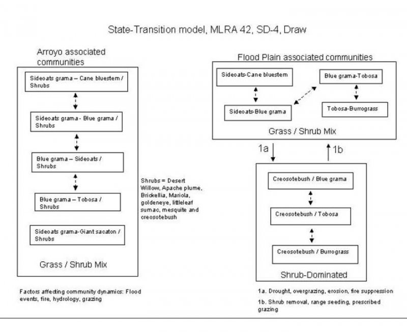
Along the channel it has the appearance of an elongated sinuous savannah with shrubs and trees dominant in aspect, however, grasses have the greatest annual production. There are an abundant variety of forbs that can occur in the understory. Vegetation is variable and is dependent on flood events, distance away from the channel, parent material, and amount of gravel and cobble in the soil profile. Sideoats grama is the dominant grass in the historic plant community. Cane bluestem, bush muhly, blue grama, and plains bristlegrass can also occur in significant numbers. Desert willow, Apache plume, brickellbush, littleleaf sumac, mariola, and mesquite are common woody species. Retrogression is characterized by a decrease in mid grasses such as sideoats grama, cane bluestem, Arizona cottontop, green sprangletop and an increase in blue grama and tobosa. Transition to the creosotebush-dominated state may occur as a result of continued loss of grass cover, erosion and lack of fire.
State and transition model

Figure 4. MLRA-42, SD-4, Draw
More interactive model formats are also available.
View Interactive Models
More interactive model formats are also available.
View Interactive Models
Click on state and transition labels to scroll to the respective text
Ecosystem states
State 1 submodel, plant communities
State 2 submodel, plant communities
State 1
HCPC
Community 1.1
Arroyo Associated Community

Figure 5. Arroyo Grass/Shrub Mix
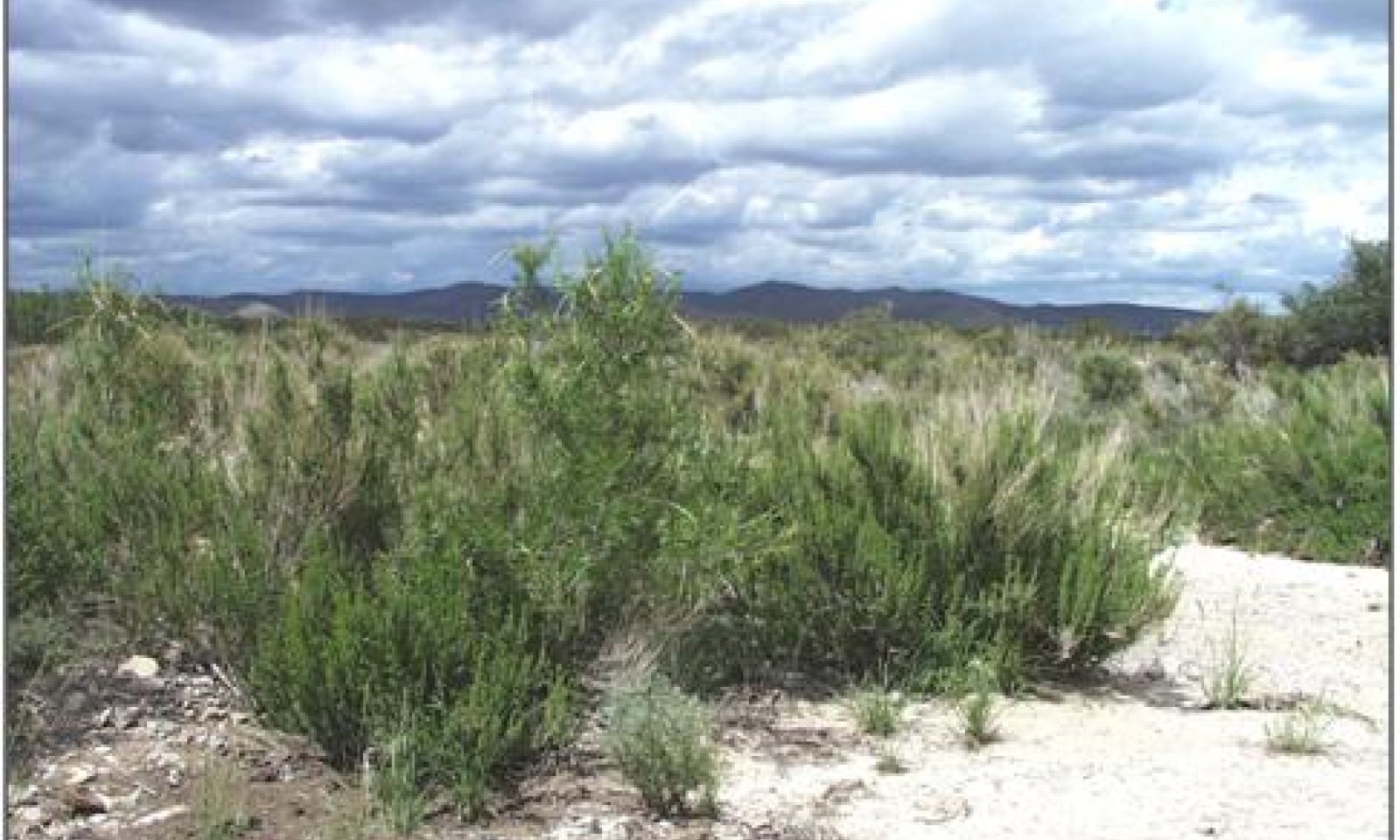
Shrubs and trees are dominant in aspect along the edges of the stream channel; however, grasses have the greatest annual production. Sideoats grama is the dominant grass species. Cane bluestem, plains bristlegrass, blue grama, bush muhly, vine mesquite, giant sacaton, and alkali sacaton are present in significant amounts. Other grasses including green sprangletop, Arizona cottontop, dropseeds, tobosa and threeawns also occur, but in more limited amounts. Shrub species along the arroyo channel include Apache plume, brickellbush, littleleaf sumac, mesquite, creosotebush, mariola and goldeneye. Desert willow is the dominant tree species. Vegetation dynamics along the arroyo are affected by changes in hydrology, flood events, grazing and fire. If the hydrology is altered by a redirection of flow or a change in channel gradient due to down cutting or deposition, vegetation communities adjust to increased or decreased available water. Higher densities of the more mesic adapted grasses such as sideoats grama, cane bluestem, green sprangletop, vine mesquite, and Arizona cottontop occur in areas that receive increased available water. Flood events can alter vegetation communities by bringing in or dispersing seed from upstream. Apache plume spreads by root suckers following flood events and subsequent burial by sediment.1 Desert willow withstands flooding and may invade sediment deposited in stream channels. Grasses such as sideoats grama, green sprangletop, Arizona cottontop, cane bluestem, and vine mesquite decrease with grazing induced retrogression. Blue grama, tobosa, alkali sacaton, and threeawns normally increase under heavy grazing pressure. In the past, fire may have played a part in suppressing and shaping the woody component on this site. Species such as desert willow, littleleaf sumac, Apache plume, goldeneye, and mariola, readily sprout following fire. Other species such as creosotebush display limited ability to sprout after top kill and are poorly adapted to fire.1
Figure 6. Annual production by plant type (representative values) or group (midpoint values)
Table 5. Annual production by plant type
| Plant type | Low (lb/acre) |
Representative value (lb/acre) |
High (lb/acre) |
|---|---|---|---|
| Grass/Grasslike | 750 | 1350 | 1800 |
| Shrub/Vine | 270 | 270 | 260 |
| Tree | 80 | 90 | 120 |
| Forb | 100 | 90 | 120 |
| Total | 1200 | 1800 | 2300 |
Figure 7. Plant community growth curve (percent production by month). NM5803, R042XD003NM Draw HPCP Arroyo Community State. R042XD003NM Draw Grassland Shrub - Sideoats grama/Willow - Average rainfall year..
| Jan | Feb | Mar | Apr | May | Jun | Jul | Aug | Sep | Oct | Nov | Dec |
|---|---|---|---|---|---|---|---|---|---|---|---|
| J | F | M | A | M | J | J | A | S | O | N | D |
| 0 | 0 | 3 | 3 | 8 | 7 | 18 | 28 | 25 | 6 | 2 | 0 |
State 2
Flood Plain
The floodplain is that portion of the site adjacent to the ephemeral stream channel formed by recurring flooding and alluvial deposition. Sideoats grama and cane bluestem are the dominant grass species. Blue grama also occurs in significant amounts. Apache plume and mariola are the dominant shrubs. Shrubs normally occur in decreasing densities moving away from the channel across the floodplain. Sideoats grama, cane bluestem, plains bristlegrass, green sprangletop and Arizona cottontop decrease under heavy grazing pressure, or from a decrease in available soil moisture, while blue grama, tobosa, and burrograss increase. The amount of rock fragments and/or carbonates in the soil profile, and moderate to low available water capacity contribute to the susceptibility of this site becoming dominated by creosotebush.
Community 2.1
Shrub/Grass Mix

Figure 8. Grass/Shrub Mix
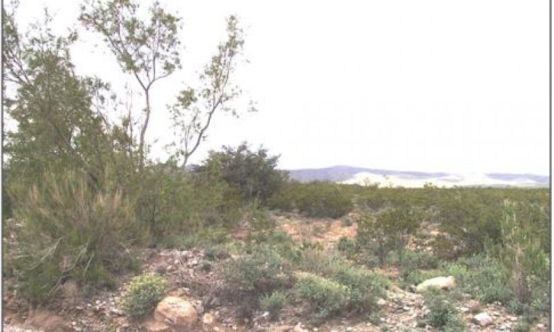
Sideoats grama and cane bluestem are the dominant grass species. Grass cover is high and fairly uniform. Shrubs are mostly confined to the channel border. Runoff is low. Litter movement occurs mainly by water but is restricted by plant cover, usually caught and concentrated around grasses and shrubs. Size class of litter moved is small (1cm.), and distance moved is typically (<1m).
Community 2.2
Shrub Dominated

Figure 9. Shrub Dominated
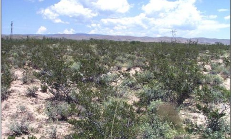
This community is characterized by the dominance of creosotebush. The dominant grasses in this state consist of blue grama, tobosa, or burrograss. Retrogression within this state usually follows the trend of a decrease in the amount of blue grama and an associated increase in tobosa and burrograss. Burrograss may eventually become the dominant grass species. Dropseeds, threeawns, muhly species, fluffgrass and broom snakeweed may also increase in representation.
Pathway 1a
Community 2.1 to 2.2


The reduction in grass cover either due to drought or overgrazing can initiate this transition. The reduction in grass cover decreases soil organic matter, reduces aggregate soil stability and negatively impacts soil structure. Creosotebush is poorly suited to fire due to its limited sprouting ability. If historically infrequent fire limited the invasion of creosotebush in desert grasslands, then fire suppression may also impact the ability of creosotebush to dominate this site.1 Opportunity to utilize fire as a management tool can be lost if herbaceous cover drops below amounts required to supply adequate fine fuels to carry fire. Key indicators of approach to transition: Reduction in grass cover and increase in size and frequency of bare patches. Increased soil surface physical crusts—indicating decreased infiltration, decreased soil aggregate stability and loss of organic matter2 Increased signs of erosion (rills & gullies) Increase in creosotebush cover
Pathway 1b
Community 2.2 to 2.1


Brush management is necessary to remove resource competition from shrubs and increase grass cover. Range seeding may be necessary if less than 15 percent of desired grass species remain. Reestablishing cover will also provide organic matter, increase aggregate stability, and reduce erosion potential. Prescribed grazing will help ensure proper forage utilization and plant vigor, especially during times of drought. The degree of erosion and loss of soil resources may dictate whether or not the system is capable of recovery.
Additional community tables
Table 6. Community 1.1 plant community composition
| Group | Common name | Symbol | Scientific name | Annual production (lb/acre) | Foliar cover (%) | |
|---|---|---|---|---|---|---|
|
Grass/Grasslike
|
||||||
| 1 | 540–630 | |||||
| sideoats grama | BOCU | Bouteloua curtipendula | 360–450 | – | ||
| cane bluestem | BOBA3 | Bothriochloa barbinodis | 180–270 | – | ||
| 2 | 200–270 | |||||
| bush muhly | MUPO2 | Muhlenbergia porteri | 120–210 | – | ||
| blue grama | BOGR2 | Bouteloua gracilis | 90–150 | – | ||
| 3 | 180–216 | |||||
| big sacaton | SPWR2 | Sporobolus wrightii | 100–120 | – | ||
| tobosagrass | PLMU3 | Pleuraphis mutica | 75–100 | – | ||
| alkali sacaton | SPAI | Sporobolus airoides | 75–100 | – | ||
| 4 | 150–180 | |||||
| plains bristlegrass | SEVU2 | Setaria vulpiseta | 120–150 | – | ||
| Arizona cottontop | DICA8 | Digitaria californica | 50–75 | – | ||
| green sprangletop | LEDU | Leptochloa dubia | 30–50 | – | ||
| spike dropseed | SPCO4 | Sporobolus contractus | 30–50 | – | ||
| sand dropseed | SPCR | Sporobolus cryptandrus | 30–50 | – | ||
| 5 | 36–54 | |||||
| threeawn | ARIST | Aristida | 36–54 | – | ||
| burrograss | SCBR2 | Scleropogon brevifolius | 36–54 | – | ||
|
Forb
|
||||||
| 6 | 18–36 | |||||
| Forb, annual | 2FA | Forb, annual | 18–36 | – | ||
| common sunflower | HEAN3 | Helianthus annuus | 6–12 | – | ||
| 7 | 36–54 | |||||
| Forb, perennial | 2FP | Forb, perennial | 36–54 | – | ||
| croton | CROTO | Croton | 18–36 | – | ||
| globemallow | SPHAE | Sphaeralcea | 18–36 | – | ||
|
Shrub/Vine
|
||||||
| 8 | 144–180 | |||||
| Apache plume | FAPA | Fallugia paradoxa | 100–150 | – | ||
| brickellbush | BRICK | Brickellia | 75–120 | – | ||
| littleleaf sumac | RHMI3 | Rhus microphylla | 50–75 | – | ||
| 9 | 36–90 | |||||
| creosote bush | LATR2 | Larrea tridentata | 36–90 | – | ||
| mariola | PAIN2 | Parthenium incanum | 36–90 | – | ||
| honey mesquite | PRGL2 | Prosopis glandulosa | 36–90 | – | ||
| goldeneye | VIGUI | Viguiera | 12–24 | – | ||
|
Tree
|
||||||
| 10 | 75–90 | |||||
| desert willow | CHLI2 | Chilopsis linearis | 75–90 | – | ||
Interpretations
Animal community
The Draw ecological sites exhibit high structural and vegetation diversity and provide thermal, nesting and hiding cover for many wildlife species. The site provides important high protein forage and browse and serves as corridors and conduits for water and wildlife movement. The draw sites are characterized by a diversity of species. A few of the species utilizing this site are mule deer, coyote, bobcat, fox, roadrunner, great-horned owl, northern mockingbird, gambel’s
quail and Texas horned lizard.
Hydrological functions
This site normally receives approximately 12-14 inches annual precipitation. Most summer rainfall occurs as brief sometimes-heavy thunderstorms. Soils are very deep and rated as being in hydrologic group B. Slopes range from 1- 5 percent. Permeability is moderately slow. Runoff is medium, and the hazard of water erosion is moderate. Available water capacity to a depth of 40 inches is very low to low.
Soil Hydrologic Unit
Oryx B
Recreational uses
This site offers recreation potential for hiking, horseback riding, camping, outdoor classrooms, nature observation, photography and hunting.
Wood products
This site has no significant value for wood products.
Other products
Grazing: The plant community on this site is well suited to grazing by both domestic livestock of all kinds and by wildlife at all seasons of the year. It is well suited to winter and early spring grazing, due to high protein levels in the forage. This site will respond well to a grazing system that rotates the season of use. When grazing sheep or goats and during calving season, predator control should be considered.
Initial starting stocking rates will be determined with the landowner or decision-maker. They will be based on past use histories and type and condition of the vegetation. Calculations used to determine and initial starting stocking rate will also be based on forage preference ratings.
Supporting information
Type locality
| Location 1: Bernalillo County, NM | |
|---|---|
| Township/Range/Section | T21 S. R12 E. S26 |
| Latitude | 32° 26′ 42″ |
| Longitude | 105° 41′ 17″ |
| General legal description | Otero County, New Mexico; approximately 23.6 miles east and 4.3 miles north of Oro Grande; SW 1/4, SE 1/4 section 26, T. 21 S., R. 12 E.; USGS El Paso Draw, NM topographic quadrangle; UTM zone 13, 435289 E, 3589784 N; NAD 27. |
Other references
1. U.S. Department of Agriculture, Forest Service, Rocky Mountain Research Station, Fire Sciences Laboratory (2002, September). Fire Effects Information System, [Online]. Available: http://www.fs.fed.us/database/feis/ [accessed 9/23/02].
2. 9. U.S. Department of Agriculture, Natural Resources Conservation Service. 2001. Soil Quality Information Sheet. Rangeland Soil Quality—Physical and Biological Soil Crusts. Rangeland Sheet 7, [Online]. Available:
http://www.statlab.iastate.edu/survey/SQI/range.html
Contributors
David Trujillo
Jason Martin
Rangeland health reference sheet
Interpreting Indicators of Rangeland Health is a qualitative assessment protocol used to determine ecosystem condition based on benchmark characteristics described in the Reference Sheet. A suite of 17 (or more) indicators are typically considered in an assessment. The ecological site(s) representative of an assessment location must be known prior to applying the protocol and must be verified based on soils and climate. Current plant community cannot be used to identify the ecological site.
| Author(s)/participant(s) | |
|---|---|
| Contact for lead author | |
| Date | |
| Approved by | |
| Approval date | |
| Composition (Indicators 10 and 12) based on | Annual Production |
Indicators
-
Number and extent of rills:
-
Presence of water flow patterns:
-
Number and height of erosional pedestals or terracettes:
-
Bare ground from Ecological Site Description or other studies (rock, litter, lichen, moss, plant canopy are not bare ground):
-
Number of gullies and erosion associated with gullies:
-
Extent of wind scoured, blowouts and/or depositional areas:
-
Amount of litter movement (describe size and distance expected to travel):
-
Soil surface (top few mm) resistance to erosion (stability values are averages - most sites will show a range of values):
-
Soil surface structure and SOM content (include type of structure and A-horizon color and thickness):
-
Effect of community phase composition (relative proportion of different functional groups) and spatial distribution on infiltration and runoff:
-
Presence and thickness of compaction layer (usually none; describe soil profile features which may be mistaken for compaction on this site):
-
Functional/Structural Groups (list in order of descending dominance by above-ground annual-production or live foliar cover using symbols: >>, >, = to indicate much greater than, greater than, and equal to):
Dominant:
Sub-dominant:
Other:
Additional:
-
Amount of plant mortality and decadence (include which functional groups are expected to show mortality or decadence):
-
Average percent litter cover (%) and depth ( in):
-
Expected annual annual-production (this is TOTAL above-ground annual-production, not just forage annual-production):
-
Potential invasive (including noxious) species (native and non-native). List species which BOTH characterize degraded states and have the potential to become a dominant or co-dominant species on the ecological site if their future establishment and growth is not actively controlled by management interventions. Species that become dominant for only one to several years (e.g., short-term response to drought or wildfire) are not invasive plants. Note that unlike other indicators, we are describing what is NOT expected in the reference state for the ecological site:
-
Perennial plant reproductive capability:
Print Options
Sections
Font
Other
The Ecosystem Dynamics Interpretive Tool is an information system framework developed by the USDA-ARS Jornada Experimental Range, USDA Natural Resources Conservation Service, and New Mexico State University.
Click on box and path labels to scroll to the respective text.