
Natural Resources
Conservation Service
Ecological site R042AD744TX
Limestone Hill, Dry Mixed Prairie
Accessed: 04/25/2025
General information
Provisional. A provisional ecological site description has undergone quality control and quality assurance review. It contains a working state and transition model and enough information to identify the ecological site.
Figure 1. Mapped extent
Areas shown in blue indicate the maximum mapped extent of this ecological site. Other ecological sites likely occur within the highlighted areas. It is also possible for this ecological site to occur outside of highlighted areas if detailed soil survey has not been completed or recently updated.
Associated sites
| R042AC244TX |
Gravelly, Desert Grassland Gravelly, Desert Grassland, is often associated in a lower position. |
|---|
Similar sites
| R042AC249TX |
Limestone Hill and Mountain, Desert Grassland The Limestone Hill & Mountain, Desert Grassland, is in a drier vegetation zone with less grass production potential. Additionally, curlyleaf muhly, blue grama, wolftail, hairy grama, banana yucca, and New Mexico agave, among others, typically not found in the site. |
|---|---|
| R042AE277TX |
Igneous Hill and Mountain, Mixed Prairie The Limestone Hill & Mountain, Mixed Prairie, site has similiar grass species composition but slightly higher production potential and shrubs and trees such as redberry juniper, mountain mahogany, and oak are typically present. |
Table 1. Dominant plant species
| Tree |
Not specified |
|---|---|
| Shrub |
Not specified |
| Herbaceous |
Not specified |
Physiographic features
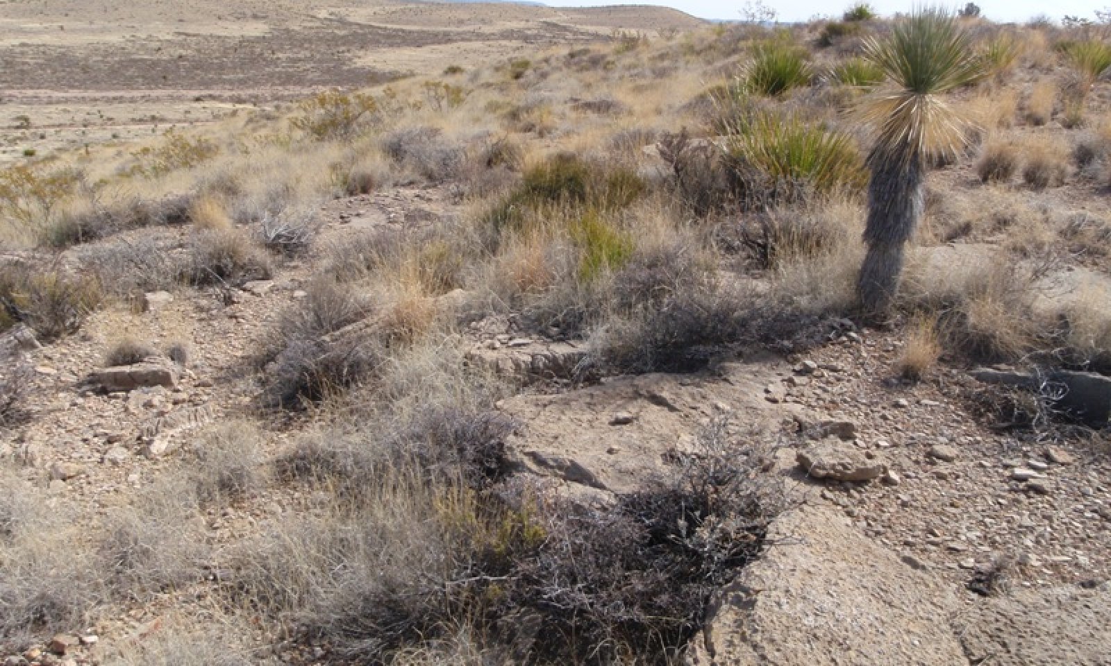
The site occurs on limestone hills with slopes ranging from 3 to 20 percent. Runoff is low on slopes less than 5 percent and medium on slopes of 5 to 20 percent.
Table 2. Representative physiographic features
| Landforms |
(1)
Hill
|
|---|---|
| Flooding frequency | None |
| Ponding frequency | None |
| Elevation | 1,372 – 1,676 m |
| Slope | 5 – 20% |
| Aspect | N, S |
Climatic features
Average precipitation for this site is approximately 12 to 14 inches. Variations of 5 inches are not uncommon. Approximately 75 percent of the precipitation occurs from May through October. Most of the summer precipitation comes in the form of high intensity short duration thunderstorms. Although little precipitation does occur during the winter months, rain and snow of low intensity usually characterise the precipitation that does occur. Temperatures are mild. Freezing temperatures are common at night from December through April, however, temperatures during the day are frequently above 50 degrees F. Occasionally in December to February brief periods of 0 degree F. temperatures may be expected. During June to August some days may exceed 100 degrees F.
The mean annual precipitation figures are derived from rain gauge data collected by the BLM (1971 to 1990), and NOAA weather maps utilizing prism model estimation techniques. There are no permanent Climate stations within the boundaries of the Land Resource Unit.
Table 3. Representative climatic features
| Frost-free period (average) | 180 days |
|---|---|
| Freeze-free period (average) | 185 days |
| Precipitation total (average) | 356 mm |
Figure 2. Monthly average minimum and maximum temperature
Influencing water features
Soil features
The site consists of very shallow to shallow gravelly and loamy soils weathered from limestone bedrock. The limestone formation can exhibit varying degrees of weathering potential resulting in “stair-step” topography. The harder, less fractured, and more weather resistant limestone layers form the “treads” and the more easily weathered and fractured layers form the steeper “risers”. Water infiltration, plant production and diversity are greater within the risers than the treads. The Bissett moist soil component is correlated to this site in the following map unit:
Bissett-Rock outcrop complex, moist, 3 to 20 percent slopes
Table 4. Representative soil features
| Parent material |
(1)
Residuum
–
limestone
|
|---|---|
| Surface texture |
(1) Very gravelly loam |
| Drainage class | Well drained |
| Permeability class | Very slow |
| Soil depth | 10 – 38 cm |
| Surface fragment cover <=3" | 10 – 35% |
| Surface fragment cover >3" | 10 – 15% |
| Available water capacity (0-101.6cm) |
0 – 5.08 cm |
| Calcium carbonate equivalent (0-101.6cm) |
40 – 80% |
| Electrical conductivity (0-101.6cm) |
0 – 2 mmhos/cm |
| Sodium adsorption ratio (0-101.6cm) |
0 |
| Soil reaction (1:1 water) (0-101.6cm) |
7.9 – 8.4 |
| Subsurface fragment volume <=3" (Depth not specified) |
30 – 40% |
| Subsurface fragment volume >3" (Depth not specified) |
4 – 15% |
Ecological dynamics
The reference or current potential plant community for the Limestone Hill, Dry Mixed Prairie ecological site is a mid and shortgrass perennial warm-season grama grassland interspersed with mixed shrubs and banded rock outcrops. Grass, shrub and forb canopy cover ranges from 65-75, 5-20, and 1-5 percent, respectively. Surface fragment cover can range up to 75 percent. The scale of the plant community for measurement is the associated soil component within the soil map units.
Fluctuations in yearly weather conditions is probably the most influential factor that helps shape the plant communities. Prolonged droughts will dramatically reduce herbaceous cover and production while wet summers will favor black grama dominance and wet winters will favor more mesic and cool-season grasses (Ludwig et al. 2000). Aspect, soil variability, and percentage of rock outcrop also play a role in shape the inherent plant community. Lightning induced fires do occur in the area but the exact frequency is unknown.
Historically, bison may have been in the area as Mescalero Apache sources suggest that their hunters headed to the Otero Mesa to hunt buffalo (McNamee 2008). The Limestone Hill ecological site occurs predominantly on the Otero Mesa in both Texas and New Mexico. In addition, desert bighorn sheep were documented to occur in the area and probably utilized the site. Both animals probably help influence the communities historically. Desert bighorn sheep are currently being reintroduced into the area. Other native fauna such as insects, rodents, mule deer, and pronghorn antelope are still helping influence the current plant communities.
Since 1885, the Otero Mesa and surrounding areas have been grazed by cattle, sheep, goats, horses, and mules. Parts of the mesa may have been ungrazed or lightly grazed because of the remoteness and ruggedness (Ludwig et al. 2000). The site is suited for prescribed grazing practices. Heavy continuous grazing, especially during dry years, over long periods will cause decreases in plants such as blue grama, black grama and increases in less palatable grasses such as sideoats grama (bunchgrass growth form), hairy grama, tridens, fluffgrass, and Neally grama. In addition, woody plants may increase in areas where the seed source is available. Ecological processes such as water and nutrient cycles may also be affected by improper grazing management.
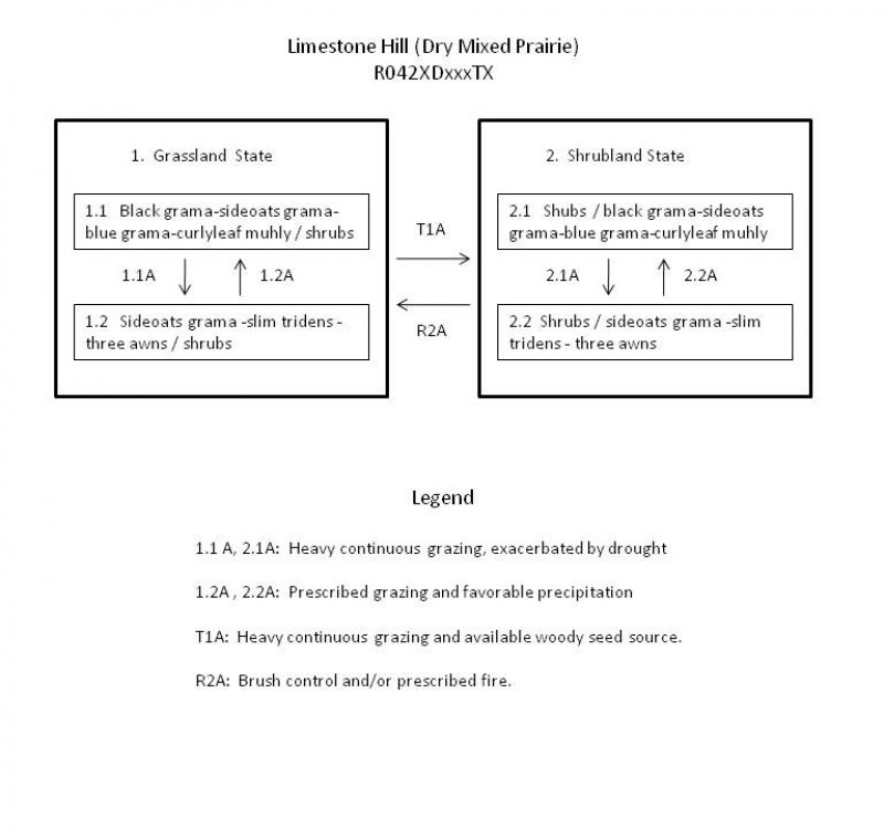
The following diagram suggests general pathways that the vegetation on this site might follow. There are other plant communities and states not shown on the diagram. This information is intended to show what might happen in a given set of circumstances; it does not mean that this would happen the same way in every instance. Local professional guidance should always be sought before pursuing a treatment scenario.
State and transition model
More interactive model formats are also available.
View Interactive Models
More interactive model formats are also available.
View Interactive Models
Click on state and transition labels to scroll to the respective text
Ecosystem states
State 1 submodel, plant communities
State 2 submodel, plant communities
State 1
Grassland
The Grassland State is characterized by a shrub canopy cover of less than 25 percent. Grama grasses dominate the herbaceous layer.
Community 1.1
Black Grama-Sideoats Grama–Blue Grama-Curlyleaf Muhly / Shrubs

Figure 3. Grama-muhly grass community with scattered shrubs
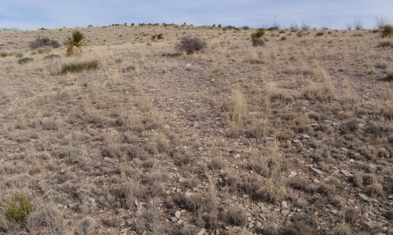
Figure 4. Grama-muhly grassland community with scattered shr
The mixed grama – curlyleaf muhly grassland is the reference or current potential vegetative community. The community is characterized by black grama, blue grama, sideoats grama, and curlyleaf muhly. Shifts in above average winter or summer precipitation can shift dominance from either black grama or sideoats and cool-season grasses. In addition, the more mesic grasses such as sideoats grama, blue grama, and curlyleaf muhly will inherently be more abundant on north facing slopes while black grama will dominate south-facing slopes. Although curlyleaf muhly is a warm season grass, during favorable weather, it is known to actively grow and flower during the spring which is similar to the growth pattern of a cool-season grass. A variety of shrubs occurs sporadically and is characterized by sotol, sacahuista, yuccas, ephedra, javelinabush, and some creosotebush. Canopy cover of shrubs can range from 5-24 percent. It is unknown if the higher shrub cover in some locations is attributed to past management or it is part of the natural variability of the site. Shrub canopy cover over 25 percent will categorize the site in the Shrubland State. The site is suited for livestock grazing and provides important wildlife habitat. Heavy continuous grazing (HCG) over several years can reduce and potentially eliminate black and blue grama while sideoats grama, threeawns, slim tridens, and hairy grama will increase. If there is an available seed source, shrubs may begin to encroach on the site.
Figure 5. Annual production by plant type (representative values) or group (midpoint values)
Table 5. Annual production by plant type
| Plant type | Low (kg/hectare) |
Representative value (kg/hectare) |
High (kg/hectare) |
|---|---|---|---|
| Grass/Grasslike | 673 | 813 | 953 |
| Shrub/Vine | 56 | 84 | 112 |
| Forb | 28 | 56 | 90 |
| Total | 757 | 953 | 1155 |
Table 6. Ground cover
| Tree foliar cover | 0% |
|---|---|
| Shrub/vine/liana foliar cover | 7-22% |
| Grass/grasslike foliar cover | 60-70% |
| Forb foliar cover | 2-5% |
| Non-vascular plants | 0% |
| Biological crusts | 0% |
| Litter | 1-3% |
| Surface fragments >0.25" and <=3" | 10-35% |
| Surface fragments >3" | 10-25% |
| Bedrock | 1-5% |
| Water | 0% |
| Bare ground | 0% |
Table 7. Soil surface cover
| Tree basal cover | 0% |
|---|---|
| Shrub/vine/liana basal cover | 2-5% |
| Grass/grasslike basal cover | 8-12% |
| Forb basal cover | 1-2% |
| Non-vascular plants | 0% |
| Biological crusts | 0% |
| Litter | 20-30% |
| Surface fragments >0.25" and <=3" | 10-35% |
| Surface fragments >3" | 10-25% |
| Bedrock | 1-5% |
| Water | 0% |
| Bare ground | 1-3% |
Table 8. Canopy structure (% cover)
| Height Above Ground (m) | Tree | Shrub/Vine | Grass/ Grasslike |
Forb |
|---|---|---|---|---|
| <0.15 | – | 0-2% | 5-10% | 1-3% |
| >0.15 <= 0.3 | – | 1-5% | 30-35% | 1-2% |
| >0.3 <= 0.6 | – | 1-5% | 25-30% | – |
| >0.6 <= 1.4 | – | 5-10% | – | – |
| >1.4 <= 4 | – | – | – | – |
| >4 <= 12 | – | – | – | – |
| >12 <= 24 | – | – | – | – |
| >24 <= 37 | – | – | – | – |
| >37 | – | – | – | – |
Figure 6. Plant community growth curve (percent production by month). TX0030, Mixed Grama/Muhly Grassland Community. Mixed grama/muhly grassland characterized by blue grama, sideoats, grama, black grama, and curly leaf muhly. .
| Jan | Feb | Mar | Apr | May | Jun | Jul | Aug | Sep | Oct | Nov | Dec |
|---|---|---|---|---|---|---|---|---|---|---|---|
| J | F | M | A | M | J | J | A | S | O | N | D |
| 1 | 1 | 1 | 3 | 3 | 10 | 15 | 25 | 25 | 10 | 5 | 1 |
Community 1.2
Sideoats grama-slim tridens-threeawn / shrub
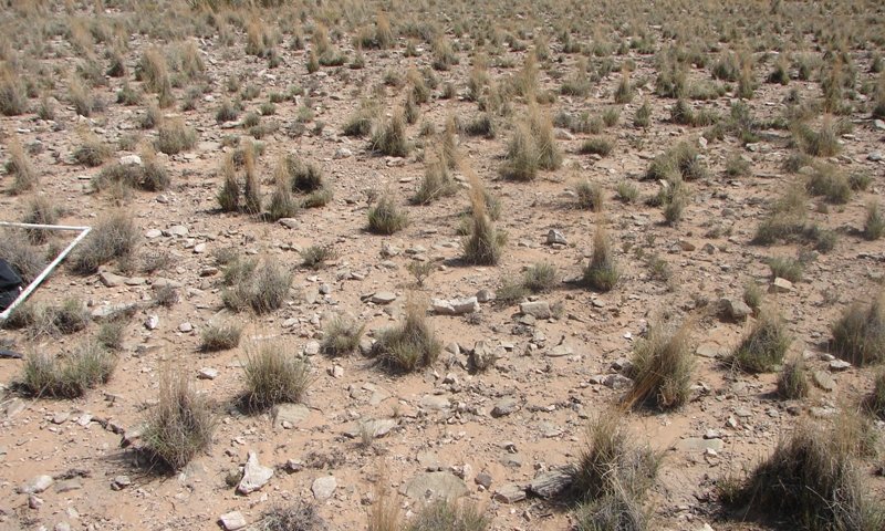
Figure 7. Sideoats grama domintated plant community
This plant community is a response to heavy continuous grazing. Drought will only exacerbate the situation. Perennial grass cover is lower and dominated by sideoats grama, slim tridens and threeawns. Both annual and perennial forbs will also increase in relative composition. Palatable grasses such as black grama and blue grama have decreased in cover. Shrubs may begin to encroach in certain areas.
Figure 8. Annual production by plant type (representative values) or group (midpoint values)
Table 9. Annual production by plant type
| Plant type | Low (kg/hectare) |
Representative value (kg/hectare) |
High (kg/hectare) |
|---|---|---|---|
| Grass/Grasslike | 336 | 448 | 560 |
| Shrub/Vine | 84 | 168 | 252 |
| Forb | 28 | 84 | 112 |
| Total | 448 | 700 | 924 |
Pathway 1.1A
Community 1.1 to 1.2


Heavy continuous grazing is the major driver causing this transition. Drought will only hasten the transition. Palatable grasses favored by livestock such as blue grama and black grama have decreased in cover while less palatable grasses such as tridens, perennial threeawns, fluffgrass, sideoats grama, and hairy grama have increased in cover. Time period for this transition is probably less than 10 years.
Pathway 1.2A
Community 1.2 to 1.1


A combination of favorable rainfall and conservation practices such as prescribed grazing can help facilitate the recovery of grasses more palatable to livestock. Rate of recovery will depend on the extent to which the site has been disturbed.
Conservation practices
| Prescribed Grazing |
|---|
State 2
Shrubland State
This state is characterized by a shrub canopy cover of 25 percent or greater and a complex of mixed grasses.
Community 2.1
Shrubs / black Grama-Sideoats Grama –Blue Grama- Curlyleaf Muhly
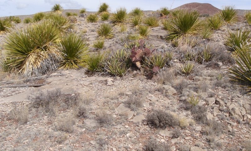
Figure 9. Sotol dominated community
It is unknown if this community is attributed to past disturbances such as heavy continuous grazing or if these areas are within the inherent variability of the site. Nonetheless, shrubs can comprise greater than 25 percent cover in areas. Common shrubs include sotol, lechuguilla, sacahuista, and creosotebush. This community can provide habitat for some wildlife that the grassland community is not able to provide and vice versa.
Community 2.2
Shrubs/ sideoats grama – slim tridens- theeawns
This plant community is a response to heavy continuous grazing. Drought will only exacerbate the situation. Perennial grass cover is lower and dominated by sideoats grama, slim tridens and threeawns. Both annual and perennial forbs will also increase in relative composition. Palatable grasses such as black grama and blue grama have decreased in cover. Shrub canopy cover is greater than 25 percent.
Pathway 2.2A
Community 2.2 to 2.1
A combination of favorable rainfall and conservation practices such as prescribed grazing and/or planned grazing system can help facilitate the recovery of grasses more palatable to livestock. Rate of recovery will depend on the extent to which the site has been disturbed.
Conservation practices
| Prescribed Grazing |
|---|
Restoration pathway R2A
State 2 to 1
Rangeland conservation practices such as brush management and possibly prescribed burning(where amount of fine fuel is adequate).
Conservation practices
| Brush Management | |
|---|---|
| Prescribed Burning | |
| Prescribed Grazing |
Additional community tables
Table 10. Community 1.1 plant community composition
| Group | Common name | Symbol | Scientific name | Annual production (kg/hectare) | Foliar cover (%) | |
|---|---|---|---|---|---|---|
|
Grass/Grasslike
|
||||||
| 1 | Warm season stoloniferous grass | 224–336 | ||||
| black grama | BOER4 | Bouteloua eriopoda | 224–336 | – | ||
| 2 | Dominant warm season bunchgrasses | 280–448 | ||||
| sideoats grama | BOCU | Bouteloua curtipendula | 112–224 | – | ||
| blue grama | BOGR2 | Bouteloua gracilis | 56–168 | – | ||
| curlyleaf muhly | MUSE | Muhlenbergia setifolia | 67–168 | – | ||
| 3 | Subdominant warm season bunchgrasses | 84–112 | ||||
| oneflower grama | BOUN | Bouteloua uniflora | 11–56 | – | ||
| hairy grama | BOHI2 | Bouteloua hirsuta | 17–34 | – | ||
| common wolfstail | LYPH | Lycurus phleoides | 17–34 | – | ||
| Hall's panicgrass | PAHA | Panicum hallii | 17–34 | – | ||
| hairy woollygrass | ERPI5 | Erioneuron pilosum | 11–28 | – | ||
| purple threeawn | ARPU9 | Aristida purpurea | 11–28 | – | ||
| sand dropseed | SPCR | Sporobolus cryptandrus | 11–28 | – | ||
| slim tridens | TRMU | Tridens muticus | 11–28 | – | ||
| plains lovegrass | ERIN | Eragrostis intermedia | 6–17 | – | ||
| streambed bristlegrass | SELE6 | Setaria leucopila | 6–17 | – | ||
| 4 | Cool season bunchgrass | 17–50 | ||||
| New Mexico feathergrass | HENE5 | Hesperostipa neomexicana | 17–50 | – | ||
| 5 | Warm season narrow leaf shortgrass | 1–6 | ||||
| low woollygrass | DAPU7 | Dasyochloa pulchella | 1–6 | – | ||
|
Shrub/Vine
|
||||||
| 6 | Shrubs | 34–67 | ||||
| desert myrtlecroton | BEOB | Bernardia obovata | 6–22 | – | ||
| javelina bush | COER5 | Condalia ericoides | 6–22 | – | ||
| rough jointfir | EPAS | Ephedra aspera | 6–22 | – | ||
| ocotillo | FOSP2 | Fouquieria splendens | 6–22 | – | ||
| creosote bush | LATR2 | Larrea tridentata | 6–22 | – | ||
| Big Bend barometerbush | LEMI4 | Leucophyllum minus | 6–22 | – | ||
| algerita | MATR3 | Mahonia trifoliolata | 6–22 | – | ||
| mariola | PAIN2 | Parthenium incanum | 6–22 | – | ||
| resinbush | VIST | Viguiera stenoloba | 6–22 | – | ||
| lotebush | ZIOB | Ziziphus obtusifolia | 6–22 | – | ||
| 7 | Sub-shrubs | 6–11 | ||||
| featherplume | DAFO | Dalea formosa | 2–6 | – | ||
| littleleaf ratany | KRER | Krameria erecta | 2–6 | – | ||
| woody crinklemat | TICAC | Tiquilia canescens var. canescens | 2–6 | – | ||
| 8 | Fibrous and succulents | 17–34 | ||||
| Havard's century plant | AGHA | Agave havardiana | 6–17 | – | ||
| lechuguilla | AGLE | Agave lechuguilla | 6–17 | – | ||
| tree cholla | CYIMI | Cylindropuntia imbricata var. imbricata | 6–17 | – | ||
| green sotol | DALE2 | Dasylirion leiophyllum | 6–17 | – | ||
| Texas sacahuista | NOTE | Nolina texana | 6–17 | – | ||
| pricklypear | OPUNT | Opuntia | 6–17 | – | ||
| banana yucca | YUBA | Yucca baccata | 6–17 | – | ||
| soaptree yucca | YUEL | Yucca elata | 6–17 | – | ||
|
Forb
|
||||||
| 9 | Perennial | 28–90 | ||||
| buckwheat | ERIOG | Eriogonum | 1–11 | – | ||
| broom snakeweed | GUSA2 | Gutierrezia sarothrae | 1–11 | – | ||
| menodora | MENOD | Menodora | 1–11 | – | ||
| beardtongue | PENST | Penstemon | 1–6 | – | ||
| polygala | POLYG | Polygala | 1–6 | – | ||
| needleleaf bluet | HOAC | Houstonia acerosa | 1–6 | – | ||
Interpretations
Animal community
The reference plant community is suited for conservative livestock grazing by cattle, horses, burros, and sheep and goats. Livestock should be stocked in proportion to the grazeable grass, forbs, and browse. Improper grazing management, especially during droughts, causes a gradual decline in range health, reducing livestock nutrition and habitat quality for some wildlife. The flower buds, blooms, and fruit of sacahuista can be toxic livestock, especially sheep and goats. A minimum toxic dose for sheep is about 1 percent of the animal’s weight in buds or blooms (Hart et al. 2003).
Wildlife that use this site for at least a portion of their overall habitat needs include mule deer, pronghorn antelope, desert bighorn sheep, coyotes, black-tailed jackrabbits, cottontails, mice, and ground squirrels. Birds that use this site as for at least a portion of their habitat needs include scaled quail, dove, raptors, and numerous song birds. Insects and reptiles such as rattlesnakes and lizards also frequent the area. Some free ranging introduced exotic ungulates that also utilize the site include oryx antelope and aoudad sheep.
Hydrological functions
The site is located in both a surface water run-in and runoff position. Surface rock fragments and a high grass cover help reduce runoff potential especially on hill slopes. Plant community 1.1 and 2.1 provide the optimum hydrologic function for the site. A reduction in grass and ground cover, as in plant communities 1.2 and 2.2, will impair the hydrologic function of the site by increasing surface runoff and decreasing water infiltration.
Recreational uses
The site can be used for hiking and hunting among other recreational uses.
Wood products
N/A
Supporting information
Other references
Reviewers and Technical Contributors:
Jim Clausen, Soil Scientist, NRCS, Marfa, TX
Joe Franklin, Zone Rangeland Management Specialist, NRCS, San Angelo, TX
Gary Fuentes, District Conservationist, NRCS, Van Horn, TX.
Lynn Loomis, Soil Scientist, NRCS, Marfa, TX
Mark Moseley, Ecological Site Inventory Specialist, NRCS, Boerne, TX
Carlos Villarreal, Soil Scientist, NRCS, Marfa, TX
Contributors
Michael Margo
Rangeland health reference sheet
Interpreting Indicators of Rangeland Health is a qualitative assessment protocol used to determine ecosystem condition based on benchmark characteristics described in the Reference Sheet. A suite of 17 (or more) indicators are typically considered in an assessment. The ecological site(s) representative of an assessment location must be known prior to applying the protocol and must be verified based on soils and climate. Current plant community cannot be used to identify the ecological site.
| Author(s)/participant(s) | Michael Margo and Carlos Villarreal, NRCS, Marfa, TX |
|---|---|
| Contact for lead author | Zone Rangeland Management Specialist, San Angelo, TX 325-944-0147 |
| Date | 06/19/2012 |
| Approved by | Kent Ferguson |
| Approval date | |
| Composition (Indicators 10 and 12) based on | Annual Production |
Indicators
-
Number and extent of rills:
None -
Presence of water flow patterns:
None, except following high intesity storms, when short (less than 1 m) and discontinuous flow patterns may appear. Flow patterns in drainages are linear and continuous. -
Number and height of erosional pedestals or terracettes:
None. -
Bare ground from Ecological Site Description or other studies (rock, litter, lichen, moss, plant canopy are not bare ground):
1-5 % bare ground. Surface rock cover can range up to 75 percent. -
Number of gullies and erosion associated with gullies:
None. -
Extent of wind scoured, blowouts and/or depositional areas:
None.
-
Amount of litter movement (describe size and distance expected to travel):
In drainages, there can be significant amounts of litter moved long distances. On most of the site, minimal and short distance (<5ft) of litter movement associated with high intense rainfall. -
Soil surface (top few mm) resistance to erosion (stability values are averages - most sites will show a range of values):
Stability class ranging from 4-5 at the surface. -
Soil surface structure and SOM content (include type of structure and A-horizon color and thickness):
Soil surface about 2 inches thick, very dark grayish brown (10YR 5/2) with a weak medium granular structure.
-
Effect of community phase composition (relative proportion of different functional groups) and spatial distribution on infiltration and runoff:
A high canopy cover of midgrass bunch and stoliniferous grasses will help minimize runoff and maximize infiltration. Grasses should comprise approximately 50-65% canopy cover. Shrubs will comprise about 5-20% canopy cover. -
Presence and thickness of compaction layer (usually none; describe soil profile features which may be mistaken for compaction on this site):
None. -
Functional/Structural Groups (list in order of descending dominance by above-ground annual-production or live foliar cover using symbols: >>, >, = to indicate much greater than, greater than, and equal to):
Dominant:
Sub-dominant:
Other:
Additional:
Stoloniferous grasses = dominant bunchgrasses > subdominant bunchgrasses=cool season bunchgrasses > shrubs > fibrous/succulents > subshrubs > forbs = fluffgrass -
Amount of plant mortality and decadence (include which functional groups are expected to show mortality or decadence):
All grasses will show some mortality and decadence in addition to annual forbs. Mid/tall perennial shrubs will show some mortality or decadence only after prolonged and severe droughts. Subshrubs will be less resistant to severe droughts than mid/tall perennial shrubs -
Average percent litter cover (%) and depth ( in):
Extended droughts and high levels of herbivory will decrease litter cover. -
Expected annual annual-production (this is TOTAL above-ground annual-production, not just forage annual-production):
675-1000 lbs/ac depending on annual rainfall -
Potential invasive (including noxious) species (native and non-native). List species which BOTH characterize degraded states and have the potential to become a dominant or co-dominant species on the ecological site if their future establishment and growth is not actively controlled by management interventions. Species that become dominant for only one to several years (e.g., short-term response to drought or wildfire) are not invasive plants. Note that unlike other indicators, we are describing what is NOT expected in the reference state for the ecological site:
Extended droughts and high levels of herbivory will decrease litter cover. -
Perennial plant reproductive capability:
All species should be capable of reproducing.
Print Options
Sections
Font
Other
The Ecosystem Dynamics Interpretive Tool is an information system framework developed by the USDA-ARS Jornada Experimental Range, USDA Natural Resources Conservation Service, and New Mexico State University.
Click on box and path labels to scroll to the respective text.