
Natural Resources
Conservation Service
Ecological site F043AY540ID
Sandy Mountain Slopes 19-24" PZ Frigid Western Bitterroot Foothills
Last updated: 10/14/2020
Accessed: 04/02/2025
General information
Provisional. A provisional ecological site description has undergone quality control and quality assurance review. It contains a working state and transition model and enough information to identify the ecological site.
MLRA notes
Major Land Resource Area (MLRA): 043A–Northern Rocky Mountains
Major Land Resource Area (MLRA): 043A–Northern Rocky Mountains
Description of MLRAs can be found in: United States Department of Agriculture, Natural Resources Conservation Service. 2006. Land Resource Regions and Major Land Resource Areas of the United States, the Caribbean, and the Pacific Basin. U.S. Department of Agriculture Handbook 296.
Available electronically at: http://www.nrcs.usda.gov/wps/portal/nrcs/detail/soils/ref/?cid=nrcs142p2_053624#handbook
LRU notes
Most commonly found in LRU 43A09 (Western Bitterroot Foothills). Also found in adjacent areas of 43A10 (Clearwater Mountains). Climate parameters were obtained from PRISM and other models for the area. Landscape descriptors are derived from USGS DEM products and their derivatives.
Classification relationships
Relationship to Other Established Classifications:
United States National Vegetation Classification (2008) - A3392 Douglas fir- P. Pine / Shrub Understory Central Rocky Mt. Forest & Woodland Alliance
Washington Natural Heritage Program. Ecosystems of Washington State, A Guide to Identification, Rocchio and Crawford, 2015 - Northern Rocky Mt. Dry-Mesic Montane Mixed Conifer Forest (D. Fir – Pine)
Description of Ecoregions of the United States, USFS PN # 1391, 1995 - M333 Northern Rocky Mt. Forest-Steppe-Coniferous Forest-Alpine Meadow Province
Level III and IV Ecoregions of WA, US EPA, June 2010 - 15x Okanogan Highland Dry Forest. 15w Western Selkirk Maritime Forest. 15r Okanogan – Colville Xeric Valleys & Foothills.
This ecological site includes the following USDA Forest Service Plant Associations: PSME/PHMA, PSME/PHMA-LIBOL and PSME/SYAL (Douglas-fir Series). (Williams et. al. 1995)
Ecological site concept
This ESD in distinguished by an overstory of ponderosa pine and Douglas-fir and an understory shrub component of ninebark, oceanspray, and snowberry. It occurs on mountainsides, and breaks. These soils have developed in mixed Mazama tephra, loess and material from granite. The soils are shallow or moderately deep to bedrock and have low available water capacity and high saturated hydraulic conductivity. The soils are well-drained or somewhat excessively drained. This ESD fits into the National Vegetation Standard’s Central Rocky Mt. Ponderosa Pine – Douglas-fir Dry shrub alliance and Washington State’s Natural Heritage Program’s Northern Rocky Mt. Dry Mesic Montane Mixed Conifer Forest.
Table 1. Dominant plant species
| Tree |
(1) Pseudotsuga menziesii var. glauca |
|---|---|
| Shrub |
(1) Symphoricarpos albus |
| Herbaceous |
(1) Maianthemum racemosum ssp. racemosum |
Physiographic features
Physiographic Features
Landscapes: Mountains, Foothills, Canyonlands
Landform: mountain slopes, hillslopes, canyon walls
Elevation (m): Total range = 595 to 1500 m
(1,950 to 4,920 feet)
Central tendency = 780 to 1075 m
(2,560 to 3,495 feet)
Slope (percent): Total range = 0 to 75 percent
Central tendency = 15 to 40 percent
Aspect:
Total range: 65-202-340
Central Tendency: 140-202-265
Table 2. Representative physiographic features
| Landforms |
(1)
Foothills
> Hillslope
(2) Mountains > Mountain slope (3) Canyonlands > Canyon wall |
|---|---|
| Flooding frequency | None |
| Ponding frequency | None |
| Elevation | 780 – 1,065 m |
| Slope | 15 – 40% |
| Water table depth | 203 cm |
| Aspect | W, SE, S, SW |
Table 3. Representative physiographic features (actual ranges)
| Flooding frequency | None |
|---|---|
| Ponding frequency | None |
| Elevation | 594 – 1,500 m |
| Slope | 0 – 75% |
| Water table depth | 203 cm |
Climatic features
Climatic Features
Frost-free period (days): Total range = 60 to 125 days
Central tendency = 95 to 115 days
Mean annual precipitation (cm): Total range = 435 to 1465 mm
(17 to 58 inches)
Central tendency = 695 to 1005 mm
(27 to 40 inches)
MAAT (C Total range = 3.6 to 8.9
(41 to 51 F)
Central tendency = 5.6 to 6.9
(45 to 47 F)
Climate Stations: none
Influencing water features
Water Table Depth: none present
Flooding:
Frequency: None
Duration: None
Ponding:
Frequency: None
Duration: None
Soil features
This ecological subsite is associated with several soil components (e.g. Lenz, Blackprince, Dystric Xerorthents, and Typic Dystrochrepts). The soil components can be grouped into: Ultic Haploxerolls, Vitrandic Haploxerepts, and Vitrandic Xerorthents. These soils have developed in mixed Mazama tephra, loess and material from granite. The soils are shallow or moderately deep to bedrock and have low available water capacity and high saturated hydraulic conductivity. The soils are well-drained or somewhat excessively drained.
Table 4. Representative soil features
| Parent material |
(1)
Volcanic ash
(2) Loess (3) Residuum – granite |
|---|---|
| Surface texture |
(1) Ashy loam (2) Gravelly sandy loam (3) Cobbly sandy loam |
| Drainage class | Well drained to somewhat excessively drained |
| Permeability class | Moderately rapid |
| Depth to restrictive layer | 79 cm |
| Surface fragment cover >3" | 0% |
| Available water capacity (0-101.6cm) |
4.32 cm |
| Calcium carbonate equivalent (0-152.4cm) |
0% |
| Electrical conductivity (0-152.4cm) |
0 mmhos/cm |
| Soil reaction (1:1 water) (0-152.4cm) |
6.1 |
| Subsurface fragment volume <=3" (25.4-152.4cm) |
12% |
| Subsurface fragment volume >3" (25.4-152.4cm) |
0% |
Table 5. Representative soil features (actual values)
| Drainage class | Well drained to somewhat excessively drained |
|---|---|
| Permeability class | Moderately rapid to rapid |
| Depth to restrictive layer | 25 – 102 cm |
| Surface fragment cover >3" | 0 – 3% |
| Available water capacity (0-101.6cm) |
3.05 – 5.84 cm |
| Calcium carbonate equivalent (0-152.4cm) |
0% |
| Electrical conductivity (0-152.4cm) |
0 mmhos/cm |
| Soil reaction (1:1 water) (0-152.4cm) |
5.1 – 7.3 |
| Subsurface fragment volume <=3" (25.4-152.4cm) |
5 – 55% |
| Subsurface fragment volume >3" (25.4-152.4cm) |
0 – 64% |
Ecological dynamics
Ecological Dynamics of the Site
The reference state occurred before European settlement when frequent low intensity fires created open stands of large ponderosa pine with a grass dominated understory of pinegrass. Patches of Douglas-fir regeneration will be present. On the lower foothills this ecological site occurs on north and east slopes. On upper mountainous terrain it will occur on southern and western aspects. Sites escaping frequent fire will have a patchy mosaic of older large trees with patches of regeneration, pole stands of ponderosa pine and Douglas-fir, and a mixture of shrubs, grasses and forbs. Bark beetle and root disease mortality will create snags and woody debris. Severe stand replacing fires can result in ceanothus shrub fields dominating for several years until natural regeneration of pine and Douglas-fir reclaim the site. In other less severe burned areas, grass and sedge species will dominate along with sprouting shrubs like ninebark, oceanspray, and snowberry.
Lack of fire or fire exclusion crosses a threshold and the site goes to another state. State 2 results in homogenous multi-storied stands of ponderosa pine and Douglas-fir with dense understories of regeneration and/or shrubs. Snags and wood debris are lacking. These stands are highly susceptible to stand replacing fires. Much of the acreage of this ecological site is in this condition. Timber stand improvement and fuel removal treatments along with prescribed fire can restore this site to a more open patchy landscape more resistant to severe fire.
In Alternative State 3 severe fire has damaged soil nutrient capacity with shrub fields of ceanothus species dominating the site for 50+ years. This condition more commonly occurring on south and west facing slopes. Restoration activities must be scrutinized on a site by site basis.
In Alternative State 4 some of the lower landscape portions of this ecological site have been converted to introduced grass pastures or annual cropland. Restoring this site to the reference state takes major inputs in site preparation, tree planting, vegetation control, fuels management and other silvicultural treatments.
State and transition model
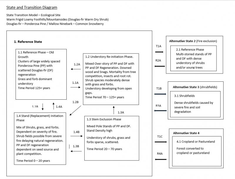
More interactive model formats are also available.
View Interactive Models
More interactive model formats are also available.
View Interactive Models
Click on state and transition labels to scroll to the respective text
State 1 submodel, plant communities
State 2 submodel, plant communities
State 3 submodel, plant communities
State 1
Reference State
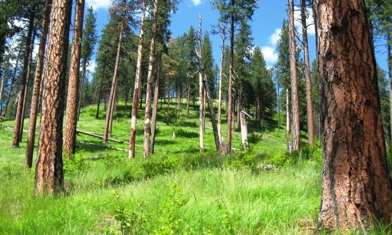
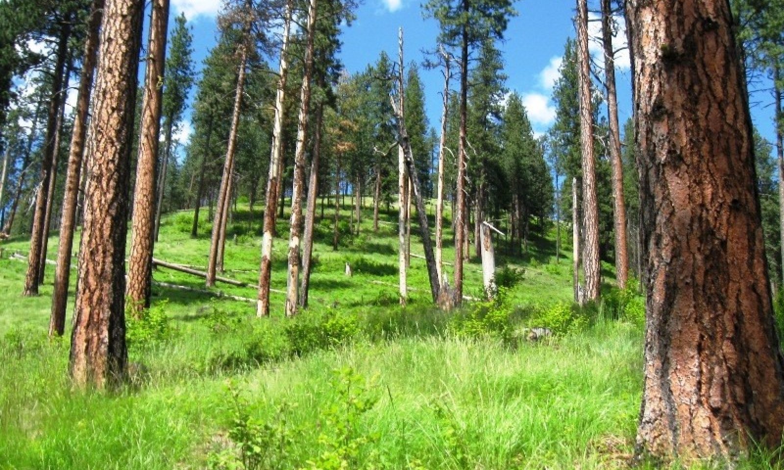
This state recognizes two forest habitat types Douglas-fir/ninebark and Douglas-fir/snowberry. They occur in close proximity and react similarly. Douglas-fir/snowberry will occur at lower landscapes and sometimes in a moister environment, snowberry being the prominent understory shrub. Ninebark and oceanspray dominate the understory of the modal Douglas-fir/ninebark habitat type. Pinegrass is the dominant grass. They occur on foothills on northern aspects at lower elevations under 3000 feet and on eastern and western aspects on mountain sides over 3000 feet. Western larch is not present on the modal soils of this state. Western larch can occur on the moister Douglas-fir/ninebark/twinflower habitat type phase and wetter Douglas-fir/snowberry sites. Wartberry fairybells and russet buffaloberry are more constant on the on the moister Douglas-fir/ninebark/twinflower site. With frequent low severity ground fires stand develops into an open stand of mostly large ponderosa pine with scattered ponderosa pine and some Douglas-fir regeneration with shrub patches mixed with grasses, mainly pinegrass, elk sedge, and Columbia brome.
Community 1.1
Reference Plant Community

This phase would be considered the historical plant community. Frequent low severity fires create an open stand of mostly large diameter 100+ year old ponderosa pine with some Douglas-fir. Tree regeneration is patchy consisting mainly of ponderosa pine with some Douglas-fir. Understory vegetation is a mix of shrubs, forbs and grasses. This phase perpetuates itself with reoccurring low intensity fires with some of the pine and fir regeneration surviving to mature stage.
Dominant plant species
-
Rocky Mountain Douglas-fir (Pseudotsuga menziesii var. glauca), tree
-
ponderosa pine (Pinus ponderosa), tree
-
common snowberry (Symphoricarpos albus), shrub
-
white spirea (Spiraea betulifolia), shrub
-
Saskatoon serviceberry (Amelanchier alnifolia), shrub
-
mallow ninebark (Physocarpus malvaceus), shrub
-
oceanspray (Holodiscus discolor), shrub
-
dwarf rose (Rosa gymnocarpa), shrub
-
creeping barberry (Mahonia repens), shrub
-
pinegrass (Calamagrostis rubescens), grass
-
Geyer's sedge (Carex geyeri), grass
-
Columbia brome (Bromus vulgaris), grass
-
feathery false lily of the valley (Maianthemum racemosum ssp. racemosum), other herbaceous
-
heartleaf arnica (Arnica cordifolia), other herbaceous
Community 1.2
Understory Re-initiation
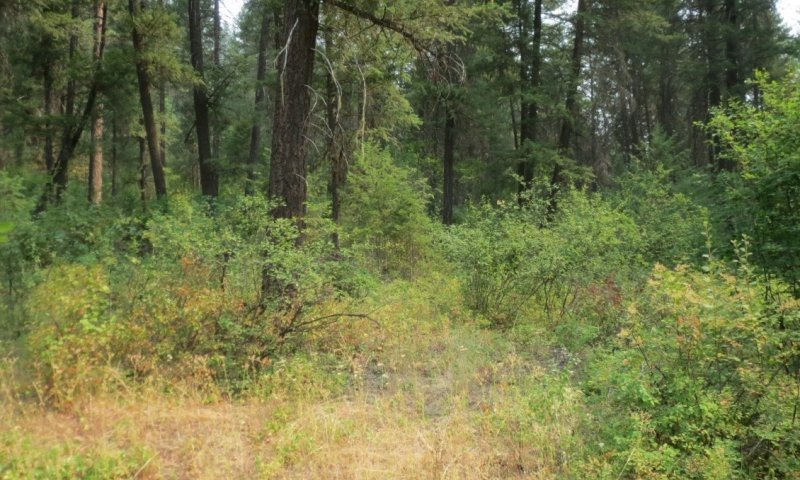
Without frequent low severity fire this plant community develops into an all aged stand of Douglas-fir and ponderosa pine with scattered remnants of old ponderosa pine. Two to three tree canopy levels can develop with an understory of ninebark, oceanspray and/or snowberry. Canopy openings can develop from windthrow or root rot pockets creating openings for Douglas-fir regeneration or shrubs. Stand is susceptible to stand replacing fires due to large fuel load and ladder fuels. Mixed severity fires will produce a mosaic of patchy large older trees with open areas of regeneration and/or dense shrubs or grass.
Community 1.3
Stem Exclusion
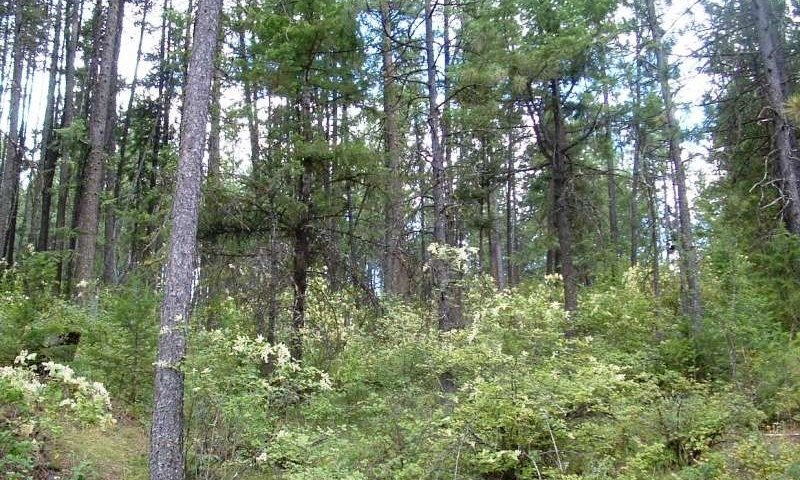
Overstory structure consists of dense one story pole stands of Douglas-fir and ponderosa pine 30-70 years old. Dense stocking creates high fire hazard and stress conditions for bark beetle attack. Armillaria root rot pockets can be present in Douglas-fir.
Community 1.4
Stand (Replacement) Initiation
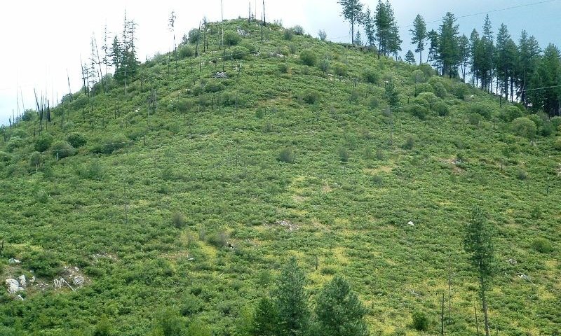
Stand replacing fires or lack of reforestation after harvest, can create dense shrub fields mixed with grass. After severe fires Ceanothus velutinus, shiny leaf ceanothus, can dominate the site and limit tree regeneration if soil duff is destroyed and surface soils are damaged. This may cause this phase to go to Alternative State 3. Natural regeneration is variable depending on fire severity. Scouler willow can also be prevalent along with pinegrass and elk sedge. In low intensity or mixed severity fires Ponderosa pine and Douglas-fir will eventually occupy the site. Future ground fires will create a patchy landscape of tree clusters and shrub/grass areas.
Pathway 1.1A
Community 1.1 to 1.2


Fire return interval extended allowing regeneration to grow and mature. Stand mortality start to occur.
Pathway 1.1B
Community 1.1 to 1.4


Stand replacement disturbance. Severe Fire or insect mortality killing large pine/fir.
Pathway 1.2A
Community 1.2 to 1.1


Pathway 1.2B
Community 1.2 to 1.4


Stand replacement disturbance. Severe Fire or insect mortality killing large pine/fir
Pathway 1.3A
Community 1.3 to 1.2


Time and localized disturbance. Stand competition mortality and insect/disease mortality creating gaps for understory development and tree regeneration
Pathway 1.3B
Community 1.3 to 1.4


Stand replacement disturbance. Severe fire back to grass/shrub stage with periodic natural tree regeneration
Pathway 1.4A
Community 1.4 to 1.1


Time. Low severity ground fires every 10-20 years to create patchy open grown ponderosa pine and Douglas-fir with grass dominant
Pathway 1.4B
Community 1.4 to 1.3


Time with fire return interval extended to allow natural tree regeneration to grow into dense pole stands
State 2
Fire Exclusion
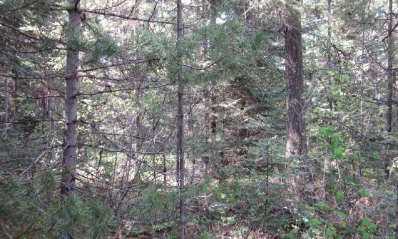
Since European settlement the fire regime has changed greatly reducing frequent low intensity ground fires that kept these forests more open, with reduced tree density more resilient to severe intensity fires. In addition, years of hygrading (harvesting largest best trees on site), overgrazing, prevalence of many roads which create fire breaks, and tree plantations has created a different forest structure. Dense multi-layered forests of Douglas-fir and ponderosa pine now exist and is homogenous on the landscape. Intensive forest management practices can reduce the risk of severe fire.
Community 2.1
Reference Phase
Multi-level canopy of mature Douglas-fir and ponderosa pine over sapling/pole/seedling stands of Douglas-fir and ponderosa pine. In areas without tree regeneration dense stands of shrubs will occur, mainly ninebark, oceanspray, or snowberry. Forest management practices which include selective overstory removal along with understory fuel load management, including prescribed fire, can transition the forest into a more drought, insect and fire resilient condition.
Dominant plant species
-
Rocky Mountain Douglas-fir (Pseudotsuga menziesii var. glauca), tree
-
ponderosa pine (Pinus ponderosa), tree
-
mallow ninebark (Physocarpus malvaceus), shrub
-
oceanspray (Holodiscus discolor), shrub
-
common snowberry (Symphoricarpos albus), shrub
State 3
Shrubfields
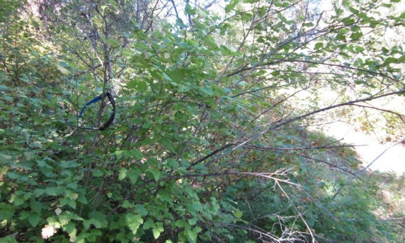
Shrub species like shiny leaf ceanothus, Scouler willow, spirea, ninebark, oceanspray thimbleberry, snowberry, chokecherry and elderberry dominate the site preventing tree establishment. Reoccurring fires keep site in shrubfield condition.
Community 3.1
Reference Phase
Shrub species like shiny leaf ceanothus, Scouler willow, spirea, ninebark, oceanspray thimbleberry, snowberry, chokecherry and elderberry dominate the site preventing tree establishment. Reoccurring fires keep site in shrubfield condition
Dominant plant species
-
ceanothus (Ceanothus), shrub
-
Scouler's willow (Salix scouleriana), shrub
-
white spirea (Spiraea betulifolia), shrub
-
mallow ninebark (Physocarpus malvaceus), shrub
-
oceanspray (Holodiscus discolor), shrub
-
thimbleberry (Rubus parviflorus), shrub
-
common snowberry (Symphoricarpos albus), shrub
-
chokecherry (Prunus virginiana), shrub
-
elderberry (Sambucus), shrub
State 4
Conversion to Cropland or Pasture
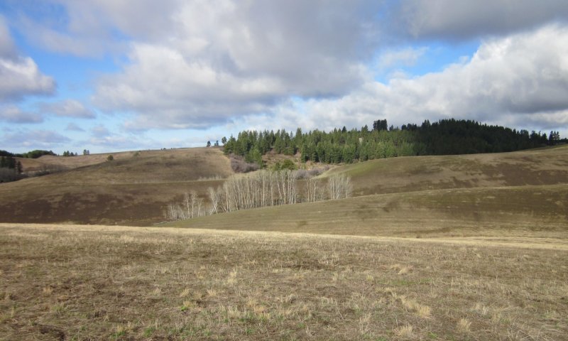
A portion of this ecological site has been converted to annual cropland or pasture. This has occurred on the lower slope foothills and valleys. Intensive tree establishment practices followed by prescribed fire once the trees are more fire resistant can lead to ecological functions of State 1.
Transition T1A
State 1 to 2


Fire exclusion over long periods allowing stands to grow into homogenous multi-storied stands
Transition T1B
State 1 to 3


Shrubfields caused by severe fire and soil degradation
Transition T1C
State 1 to 4


Forest stands converted to cropland or pastureland
Restoration pathway R2A
State 2 to 1


Forest stands restored by overstory thinning, ground and ladder fuels reduction, prescribed fire and seeding of native grasses and forbs.
Restoration pathway R3A
State 3 to 1


Careful selection of sites to determine if tree planting success is warranted.
Restoration pathway R4A
State 4 to 1


Afforestation through planting of native trees /shrubs and seeding of native grasses and forbs, treatment of invasive plants and Time.
Additional community tables
Interpretations
Supporting information
References
-
. 1998. NRCS National Forestry Manual.
-
. 2017. NRCS Soil and Site Index data for NE WA and N. Idaho.
-
Cooper, S.V., K.E. Neiman, R. Steele, and D.W. Roberts. 1991. Forest Habitat types of Northern Idaho, A Second Approximation.
-
Finklin, A.I. 1983. Climate of Priest River Experimental Forest, northern Idaho. Gen. Tech. Rep. INT-159. U.S. Department of Agriculture, Forest Service, Intermountain Forest and Range Experiment Station, Ogden, UT. 53.
-
Smith and Fischer. 1997. Fire Ecology of the Forest Habitat Types of Northern Idaho.
-
Williams, C.K., B.F. Kelley, B.G. Smith, and T.R. Lillybridge. October, 1995. Forested Plant Associations of the Colville National Forest.
-
Zack, A. 1997. Biophysical Classification- Habitat Groups and Description of Northern Idaho and Northwestern Montana, Lower Clarkfork and Adjacent Areas..
Approval
Curtis Talbot, 10/14/2020
Rangeland health reference sheet
Interpreting Indicators of Rangeland Health is a qualitative assessment protocol used to determine ecosystem condition based on benchmark characteristics described in the Reference Sheet. A suite of 17 (or more) indicators are typically considered in an assessment. The ecological site(s) representative of an assessment location must be known prior to applying the protocol and must be verified based on soils and climate. Current plant community cannot be used to identify the ecological site.
| Author(s)/participant(s) | |
|---|---|
| Contact for lead author | |
| Date | 04/02/2025 |
| Approved by | Curtis Talbot |
| Approval date | |
| Composition (Indicators 10 and 12) based on | Annual Production |
Indicators
-
Number and extent of rills:
-
Presence of water flow patterns:
-
Number and height of erosional pedestals or terracettes:
-
Bare ground from Ecological Site Description or other studies (rock, litter, lichen, moss, plant canopy are not bare ground):
-
Number of gullies and erosion associated with gullies:
-
Extent of wind scoured, blowouts and/or depositional areas:
-
Amount of litter movement (describe size and distance expected to travel):
-
Soil surface (top few mm) resistance to erosion (stability values are averages - most sites will show a range of values):
-
Soil surface structure and SOM content (include type of structure and A-horizon color and thickness):
-
Effect of community phase composition (relative proportion of different functional groups) and spatial distribution on infiltration and runoff:
-
Presence and thickness of compaction layer (usually none; describe soil profile features which may be mistaken for compaction on this site):
-
Functional/Structural Groups (list in order of descending dominance by above-ground annual-production or live foliar cover using symbols: >>, >, = to indicate much greater than, greater than, and equal to):
Dominant:
Sub-dominant:
Other:
Additional:
-
Amount of plant mortality and decadence (include which functional groups are expected to show mortality or decadence):
-
Average percent litter cover (%) and depth ( in):
-
Expected annual annual-production (this is TOTAL above-ground annual-production, not just forage annual-production):
-
Potential invasive (including noxious) species (native and non-native). List species which BOTH characterize degraded states and have the potential to become a dominant or co-dominant species on the ecological site if their future establishment and growth is not actively controlled by management interventions. Species that become dominant for only one to several years (e.g., short-term response to drought or wildfire) are not invasive plants. Note that unlike other indicators, we are describing what is NOT expected in the reference state for the ecological site:
-
Perennial plant reproductive capability:
Print Options
Sections
Font
Other
The Ecosystem Dynamics Interpretive Tool is an information system framework developed by the USDA-ARS Jornada Experimental Range, USDA Natural Resources Conservation Service, and New Mexico State University.
Click on box and path labels to scroll to the respective text.