Montane Fen woollyfruit sedge (Carex lasiocarpa)

Scenario model
Current ecosystem state
Select a state
Management practices/drivers
Select a transition or restoration pathway
- Transition T1A More details
- Transition T1B More details
- Restoration pathway R2A More details
- Restoration pathway R3A More details
-
No transition or restoration pathway between the selected states has been described
Target ecosystem state
Select a state
State 1
Reference
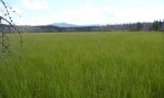
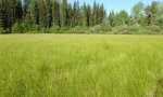
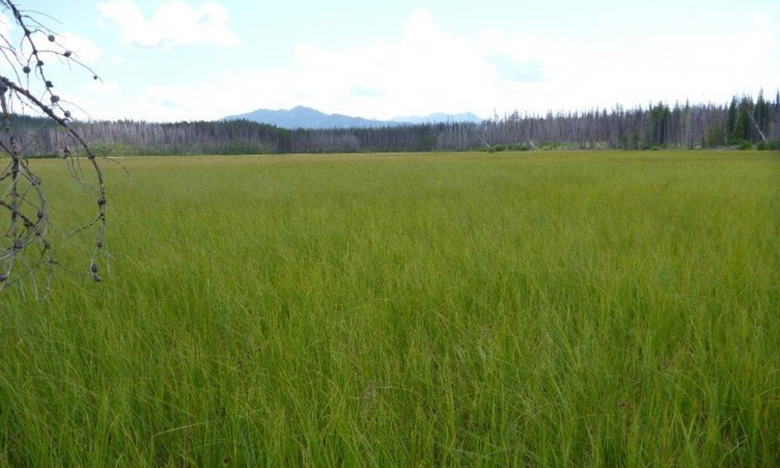
Description
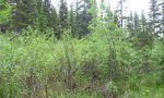
These wetland communities occur in peatlands dominated by all wetland obligate species meaning that they almost always occur (estimated probability greater than 99 percent) under natural conditions in wetlands. These occur on depressions within meadows in valley or glacial basins near sloping uplands or ground moraines. Soils are saturated from ground water discharge, sheet flow and periodic ponding. The melt out of snow in spring produces ponding of cold water that, with cold soil temperatures lowers the decomposition rate of plant material leading to accumulation of peat (organic material mantle). Typically, the native plant species within the reference phase are all obligate wetland carex species that have high foliar cover, and are very productive. In other areas with slightly less saturated soils, carr type (shrubby) fens occur which are dominated by wetland affiliated shrubs Betula nana and or Salix drummondiana with an understory of carex and juncus species.
Disturbance dynamics within the natural functioning state include: fire, beaver dams, low precipitation or snowpack years and ungulate grazing. These disturbances are viewed as potentially changing the plant population composition to a minor extent from one phase to another within State 1 but with the ability to return to any phases with time after disturbance. These disturbances affect hydrology which is critically important to this site. Moderate disturbance will increase baltic rush (Juncus balticus) and associated forbs (Hansen, 1992), while severe disturbance may lower the water table and cause the site to be dominated by species such as Kentucky bluegrass (Poa pratensis), fowl bluegrass (Poa palustris), common silverweed (Potentilla anserina) or redtop (Agrostis stolonifera) (Hansen, 1992). Moderately disturbed sites will improve rapidly with protection due to the rhizomatous nature of slender sedge (Carex lasciocarpa). This site is flooded long enough to provide nesting habitat for waterfowl, but has limited use by songbirds and small mammals because of the lack of diversity and flooded soils. It is an important habitat for raptors, deer, and elk. Beaver dams assist in controlling the downcutting of channels, bank erosion, and the movement of sediment downstream (Gordon and others 1992). When beaver construct a dam, they raise the water table in the area, which provides water for hydrophytic plants. The beaver dam also slows down the water in the channel, which allows suspended sediment to be deposited behind the dam. The combination of sediment deposition and plant reproduction raises the channel bed (Hansen, 1992).
Fire can occur, though rarely and only in dry years within fens. These fires would eliminate conifer and shrub encroachment on the site and maintain the reference phase community dominated by sedges. Typically, fires would only top burn the current year’s growth of the sedges. In particular, Carex lasciocarpa and Carex utriculata are resistant to damage by fire through their extensive root system and resprouting capabilities, except where hot fires penetrate the peat soil. As well, Carex utriculata can be in the soil seed bank up to 46 cm or 18 inches deep, so it may establish from on-site seed after fire. Fire in fens is highly dependent upon the surrounding vegetation type carrying the fire to these saturated sites. Within Glacier National Park, the subalpine fir/queencup beadlily ecological site typically surrounds these fens, which has low occurrence but high severity and has a fire free interval of approximately 130 years. Generally, these fens are so saturated that fires will move around these low lying areas and stay within the conifer community. Low or mixed severity fires only account for 32% of the fires and have a mean interval of 750 years in the Northwest (USDA, USFS, Fire Effects Information System, Fire Regimes). High severity fires that occur during severe drought years, account for 68% of the fires occurring and have a mean interval of 350 years (USDA, USFS, Fire Effects Information System, Fire Regimes). So, fires are rare within this site, but would serve to limit conifer and shrub encroachment. If a severe fire would occur within a fen and destroy the rhizomes of the sedges, then a threshold would be crossed and major species composition could occur. Fire in surrounding forested communities could also impact the hydrology of the fen and cause increased runoff, and potentially groundwater flow, by decreasing live trees upslope and potentially change the species composition of the fen (Steve Shelly, personal communication, 2015). As well, extensive epidemics of forest disease or pests that lead to large scale death of trees could attain the same result. Two sites were on the boundary of major fires on the west side of the continental divide (Robert fire in 2003 burned 54,191 acres and the Moose fire in 2001 burned 66,688 acres). However, the sites did not have evidence of burning.
Beaver damming, within the areas that do have some water flow in channels, can lead to changes in plant species composition by flooding one area and concomitantly drying another. These are viewed as naturally functioning disturbances that would lead to ponding and inundation of an area and therefore drying of another area leading to potentially shrub invasion and if long enough, conifer invasion to a small scale. Presence of beaver damming would potentially lead to a mosaic effect on the plant communities potentially as opposed to the typical saturated fen with sedge vegetation within a larger landscape of conifer dominated environment or a less saturated carr type of fen with Betula nana or Salix species.
Low precipitation or drought years that impact precipitation and snow melt could potentially cause change in plant species composition by allowing shrubs in invade the site. Less precipitation and snow melt would decrease current year growth of the dominant sedge species at the reference phase, and allow drier site shrubs to potentially invade, but would not cause a state change since a resumption of normal precipitation would generally lead to resumed saturated conditions that preclude shrub encroachment. A severe drought that would adversely affect the sedge community and allow the establishment of dry site species would have crossed a threshold and cause a state change.
Ungulate grazing would be considered within the range of normal functioning disturbances that may change some species composition within State 1 if it were light grazing, seasonal or rotational, did not lead to extensive trailing, wallowing or cut banking of flow through channels. Ungulate hoof action can break up the rhizomatous sod, which can lead to unvegetated microsites conducive to shrub encroachment; in addition, pugging and hummocking can create some surface flow patterns which may accelerate water loss from the peatland. Urine and feces can change nutrient concentration as well. If the ungulate use is low, then it is viewed as normally functioning. Carex utriculata is considered moderately tolerant of grazing, though it may be replaced by other species when heavily grazed over extended periods. The saturated soils likely are susceptible to trampling and compaction though high water tables throughout the growing season tend to limit access by livestock and thereby reduce impacts. If the ungulate use if high, concentrated or during sensitive periods of plant growth, the impact can be severe and cause a state change by affecting soil compaction, water loss through trailing, pugging, hummocking changing surface flow patterns, severe changes in nutrient concentration through very high levels of urine and feces as well. These disturbances also could be exacerbated by drought or other disturbances higher upslope in the watershed that affect groundwater discharge and surface sheet flow.
Large scale timber harvesting upslope or higher in the adjacent watershed to the fen can cause a state change to occur. If there were a large, extensive clear-cut that caused abrupt changes in the hydrology upslope of the fen and affect groundwater or surface flows these would cross a threshold and cause either a state change to dry site species, or an increase in run-in to the peatland since the removal of trees reduces the water uptake. In addition, loss of shading by adjacent conifers may likely be beneficial to the peatlands as most of the species are shade-intolerant. Very small scale timber harvesting or that was not clear-cut prescription, would not cause a threshold to be crossed and a state change to occur. This dry site species community could be more at risk to weed species invasion including timothy (Phleum pratense), Canada thistle (Cirsium arvense) or reed canarygrass (Phalaris arundinacea). Overstocked surrounding forests can potentially alter the water balance of fens by taking up more water in the trees than a non-overstocked forest.
Road building upslope or higher in the watershed from a fen could cause a threshold to be crossed and a state change to occur if it impacted surface flow to a degree that most of the upslope water is diverted away from the lower fen. Less groundwater or surface flow would cause drying of the site leading to dry site species invading and possibly weedy species as well. Water well establishment in the vicinity or upslope of the fen could cause less groundwater available to maintain saturated soils for the site and could cause a threshold to be crossed and a state change to dry site species to occur. As well, any ditching or draining of fen would cause a threshold to be crossed in the normal functioning hydrology of the fen and a state change to dry site species would occur. This site would be more vulnerable to weedy species invasion. Peat mining could also cause a threshold to be crossed if it greatly impacted the hydrology or was extensive enough that the sedges were unable to recolonize the impacted areas. Point source pollution that degraded the plant community functioning, vigor or changed the hydrology or nutrient concentration significantly could cause a threshold to be crossed and a state change to occur.
This ecological site can occur, though less frequently, in subalpine and alpine areas, in kettles on glacial basin and valley landforms, on flat slopes of all aspects, at elevations ranging 7,000 to 8,000 feet. These fens are included into this report on montane fens as a high elevation variant to low elevation fens. These fens are considered to be intermediate between Rich and Poor types with low to moderate pH (compared to “Poor” fens with pH <5.4 and “Rich” fens with pH 6-7, and “Extremely rich” fens with pH >7), intermediate to high moss cover, intermediate to low plant cover, and intermediate to low productivity of vascular plant and intermediate calcium concentration. The predominant substrate is Metasedimentary. This is in contrast to the low elevation “Rich” fens found in the montane life zone. The growing season in these high elevation sites is short and this may have an effect on shrub and conifer encroachment. The native reference community has high moss cover that is a mixture of species including: sphagnum, drepancladus, aulocomnium and other moss species. The vascular plant species foliar cover is fairly low and is a mixture of mainly equisetum and carex species although juncus, forb and grass species do occur in low to very low cover. The main plant species encountered include field horsetail (Equisetum arvense), variegated scouringrush (Equisetum variegatum), northern bog sedge (Carex gynocrates), Payson’s sedge (Carex paysonis), shortstalk sedge (Carex podocarpa). This community is dominated by species that are wetland obligate to facultative species designated and the site is saturated with a high water table for nearly the entire year and can experience brief, frequent ponding and overland sheet flow of water. The ground cover is predominantly moss with a trace cover of water, lichen, and litter. The plant species within the reference phase are all obligate or facultative wetland equisetum and carex species that have low foliar cover, and are not very productive in this high elevation setting. In the surrounding areas, there may be Salix dominated carr fens and upslope forests of Abies lasiocarpa, Pinus albicaulis and Larix lyallii. Carex gynocrates is an obligate wetland species meaning it almost always occur (greater than 99% estimated probability) under natural conditions in wetlands. Carex paysonis is a FACU species meaning it usually occurs in non-wetlands (67-99% probability), but is occasionally found in wetlands. Carex podocarpa is a FAC species, meaning it is equally likely to occur in wetlands and non-wetlands. Equisetum arvense is considered poor forage palatability for cattle, sheep and horses meaning it is not relished and normally is consumed to only a small degree or not at all (Hansen, 1992). Equisetum arvense is a FAC wetland species with low energy and protein value. FAC refers to species that are equally likely to occur in wetlands or non-wetlands. Low energy and protein values denotes that it has poor retention of usable energy and digestible protein during fall and winter (Hansen, 1992). It has poor food value for elk, mule and whitetail deer and antelope. As well, it is poor food value for upland game birds, waterfowl, small non-game birds and small mammals.
Submodel
Submodel
Description
This is species composition change from State 1.0 due to pollution from a point source. The effect of this pollution may be species composition change, loss of plant vigor or loss of plant cover dramatically.
Submodel
Model keys
Briefcase
Add ecological sites and Major Land Resource Areas to your briefcase by clicking on the briefcase (![]() ) icon wherever it occurs. Drag and drop items to reorder. Cookies are used to store briefcase items between browsing sessions. Because of this, the number of items that can be added to your briefcase is limited, and briefcase items added on one device and browser cannot be accessed from another device or browser. Users who do not wish to place cookies on their devices should not use the briefcase tool. Briefcase cookies serve no other purpose than described here and are deleted whenever browsing history is cleared.
) icon wherever it occurs. Drag and drop items to reorder. Cookies are used to store briefcase items between browsing sessions. Because of this, the number of items that can be added to your briefcase is limited, and briefcase items added on one device and browser cannot be accessed from another device or browser. Users who do not wish to place cookies on their devices should not use the briefcase tool. Briefcase cookies serve no other purpose than described here and are deleted whenever browsing history is cleared.
Ecological sites
Major Land Resource Areas
The Ecosystem Dynamics Interpretive Tool is an information system framework developed by the USDA-ARS Jornada Experimental Range, USDA Natural Resources Conservation Service, and New Mexico State University.