Natural Resources
Conservation Service
Ecological site R043AY517ID
Frigid Aquic-Udic Loamy Flood Plains (ALIN/COSE/CAREX)
Last updated: 10/15/2020
Accessed: 02/09/2026
General information
Provisional. A provisional ecological site description has undergone quality control and quality assurance review. It contains a working state and transition model and enough information to identify the ecological site.
MLRA notes
Major Land Resource Area (MLRA): 043A–Northern Rocky Mountains
Description of MLRAs can be found in: United States Department of Agriculture, Natural Resources Conservation Service. 2006. Land Resource Regions and Major Land Resource Areas of the United States, the Caribbean, and the Pacific Basin. U.S. Department of Agriculture Handbook 296.
Available electronically at: http://www.nrcs.usda.gov/wps/portal/nrcs/detail/soils/ref/?cid=nrcs142p2_053624#handbook
LRU notes
Major land resource area (MLRA): 043A-Northern Rocky Mountains
Modal LRU – 43A09 Western Bitterroot Foothills
This LRU is composed predominantly of mid-elevation foothills, mountain slopes, ridges, valley walls, plateaus, and low elevation foothills, canyons, structural benches, valleys, and escarpments. The soils tend to be loamy vitrands, and cryands. Quartzite and other metamorphic deposits are the dominant parent materials. Soil climate is a mesic to frigid temperature regime and xeric to udic moisture regime with average annual precipitation around 895 mm (35 inches).
Others where occurring – 43A07 - Eastern Columbia Plateau Embayments
43A10 – Clearwater Mountains
43A11 - Bitterroot Metasedimentary Zone
Classification relationships
This ES fits into the National Vegetation Standard’s Western Montane-Subalpine Riparian & Seep Shrubland Group (Compare to previous Idaho range sites: R009XY018ID, MEADOW and R043BY011, RIPARIAN)
Ecological site concept
This ES is found on somewhat poorly drained to poorly drained, loamy sites on floodplains. A water table can be present and is within 61 cm (24 inches) of the surface during the May-Oct period. They have frigid temperatures and a plant community that varies from riparian woody species to sedges and grasses. These are montane wetlands dominated by short to tall (0.5-15 m) cold-deciduous shrubs with multiple stems, occurring as narrow bands of shrubs lining streambanks and alluvial terraces in narrow to wide, low-gradient valley bottoms and floodplains with sinuous stream channels.
Table 1. Dominant plant species
| Tree |
Not specified |
|---|---|
| Shrub |
(1) Alnus incana |
| Herbaceous |
(1) Carex |
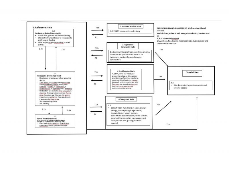
Click on box and path labels to scroll to the respective text.

