Dense Clay (DC) Absaroka Upper Foothills
Scenario model
Current ecosystem state
Select a state
Management practices/drivers
Select a transition or restoration pathway
-
Transition T1-2
Frequent and severe use is the driver of this transition.
More details -
Transition T1-3
Drought alone or with other surface disturbances, including grazing, with a seed source present will force this transition.
More details -
Restoration pathway R2-1
Long-term prescribed grazing will convert this community phase.
More details -
Transition T2-3
Repeated extensive use by recreational traffic, livestock or others with seed sources present leave this state at risk of transitioning to the Invaded State.
More details -
Restoration pathway R3-4
Seeding, soil amendments, weed control and prescribed grazing will aid in recovery of this site.
More details -
Transition T4-3
Drought alone or with other surface disturbances, including grazing, with a seed source present will force this transition.
More details -
No transition or restoration pathway between the selected states has been described
Target ecosystem state
Select a state
State 1
Rhizomatous Wheatgrasses/Sagebrush


Description
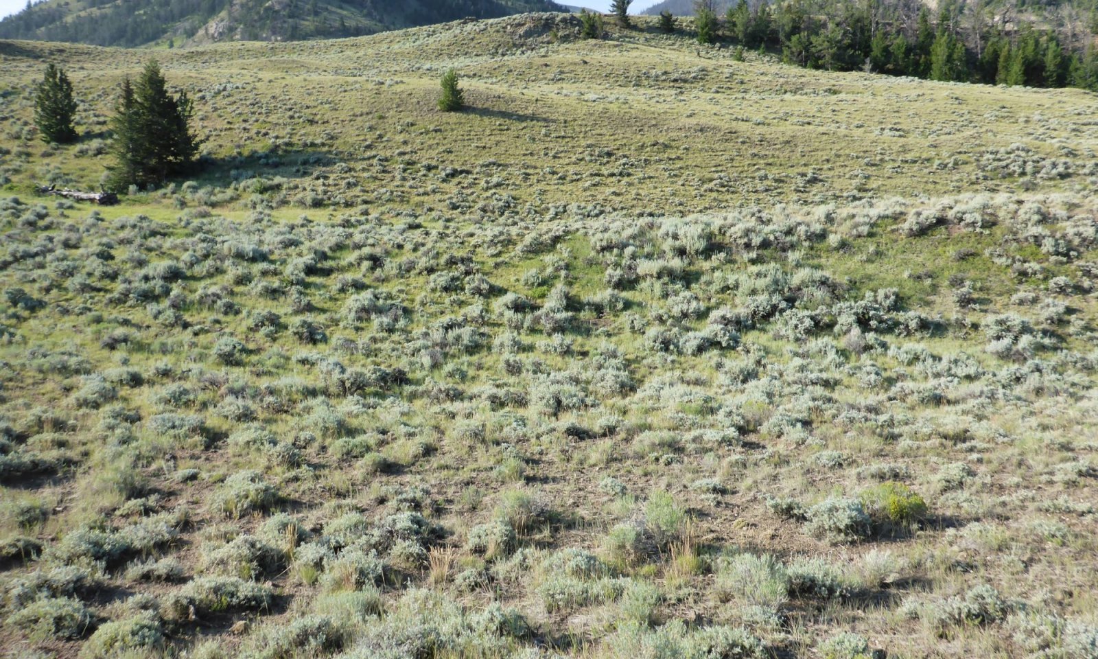
The Dense Clay ecological site is generally small on the landscape, but is also very distinct with the low vegetative profile. This birdfoot sagebrush and dwarfed mountain big sagebrush dominated site is prominently displayed in a patchwork with vigorous mountain big sagebrush of neighboring ecological sites. The herbaceous cover consists of a mixture of mid-stature and short-stature cool-season bunchgrasses and rhizomatous grasses.
Characteristics and indicators
A diverse mixture of key perennial grasses, forbs and short-stature sagebrush is the key characteristic of this State. The high clay content causes significant surface cracking and plants are limited in ground cover as well as in canopy because of the droughty soil conditions.
Resilience management
The vegetation of this State are resilient to drought and and frequent use, creating a community that tends to be resistant to degradation. However, with long-term or repeated pressures, this community will begin to lose the herbaceous understory.
Submodel
Description
The harsh environment presented by the soils of the Dense Clay ecological site limit the persistence of most perennial grasses. Although, the species that are key to this site are resilient species, after long term pressure, the community will shift to a sagebrush community with significant bare ground.
Characteristics and indicators
The lack of herbaceous vegetation within the sagebrush canopy is the key indication of being in this community. A small cover of forbs may occur a scattering of short-stature grasses, but most grasses are not present.
Resilience management
Once this community has established recruitment of key grasses is difficult making this community resilient and resistant to change. The tight soil surface, and droughty nature of the fine textured soils, limits seedling establishment.
Submodel
Description
This state, the Invaded State, is less conspicuous than neighboring ecological sites. Cheatgrass and other invasive species will establish in this community, but do not tend to become extensive. The restrictive traits of the dense clays limit seedling establishment of most weedy species. Field cottonrose, thistle, and cheatgrass are potential invaders.
Characteristics and indicators
The significant presence of an invader species, at least 5 percent by cover, qualifies a State as being invaded. The species of consideration are any non-native species, listed noxious weed (native or introduced) and species of local concerns (weed issues).
Resilience management
As annuals or other invasive species increase the native grasses are weakened and will be significantly reduced in the community. This limited community is resistant and resilient against change. Cheatgrass may be a common threat, but unlike other sagebrush communities, the woody cover is able to maintain and prevent the dense monoculture stands of Cheatgrass. The corresponding fire risk of cheatgrass is muted by the reduced fine fuels.
Submodel
Description
This state is a dynamic state to capture those communities that have been disturbed or altered due to alternative uses including recreation, farming, energy development and other general land uses with soil surface disturbances.
Characteristics and indicators
The visual signs of disturbance or manipulation are obvious in the soil surface and vegetation patterns. The presence of seeded species is a key indication of an altered landscape, or the visible rows of vegetation that will persist for years following a drill seeding. Many times, pitting or surface roughening techniques will remain visible on the soil for significant periods of time.
Resilience management
The level and extent of disturbance varies greatly between uses. These are all factors considered in the following Community description and limits the resilience and resistance.
Submodel
Mechanism
Frequent and severe grazing, will convert the plant community to the Birdfoot Sagebrush/Bare Ground Community Phase. The probability of this occurring is high on areas where birdfoot sagebrush is not adversely impacted by heavy browsing and prolong drought has occurred.
Constraints to recovery
The ability for native grasses to establish in this tough soil.
Mechanism
Drought, Disturbance or Over-use with Seed Source present - When drought or a disturbance such as over-use by grazers occurs the vulnerability of the state is opened and when there is a seed source present, invasive species can gain a foot hold quickly due to the open canopy and low plant density.
Constraints to recovery
Recovery is limited to the ability to control or eradicate the species of invasion.
Mechanism
Prescribed grazing or possibly long-term prescribed grazing, will convert this plant community to the Reference State. The probability of this occurring is high especially if rotational grazing along with short deferred grazing is implemented as part of prescribed method of use. Brush management is not usually necessary at the time these grazing systems are implemented.
Context dependence
The seed bank or nursery stock is needed to aid the recovery process in the system.
Mechanism
Continued Disturbance or Lack of Use/Management with Seed Source present - Repeated extensive use by recreational traffic is common on the raw or "disturbed" appearance of reclaimed or manipulated areas. These at-risk locations are vulnerable to weed encroachment, especially by aggressive invasive species that are persistent within the Big Horn Basin and lower foothills. Cheatgrass has seed sources readily available and easily transported on tires, undercarriages, animals, and humans. With continued presence of activity or movement through disturbed or establishing communities, the risk of transitioning to an invaded state increases.
Constraints to recovery
The ability to control the invasive species is the major constraint to recovery for this community.
Mechanism
Grazing management after the use of seedings following soil amendments or other techniques to aid establishment of native or improved varieties and an intense weed management plan will aid the recovery of this community.
Mechanism
Drought, Disturbance or Over-use with Seed Source present - When drought or a disturbance such as over-use by grazers occurs the vulnerability of the state is opened and when there is a seed source present, invasive species can gain a foot hold quickly due to the open canopy and low plant density.
Constraints to recovery
Recovery is limited to the ability to control or eradicate the species of invasion.
Model keys
Briefcase
Add ecological sites and Major Land Resource Areas to your briefcase by clicking on the briefcase (![]() ) icon wherever it occurs. Drag and drop items to reorder. Cookies are used to store briefcase items between browsing sessions. Because of this, the number of items that can be added to your briefcase is limited, and briefcase items added on one device and browser cannot be accessed from another device or browser. Users who do not wish to place cookies on their devices should not use the briefcase tool. Briefcase cookies serve no other purpose than described here and are deleted whenever browsing history is cleared.
) icon wherever it occurs. Drag and drop items to reorder. Cookies are used to store briefcase items between browsing sessions. Because of this, the number of items that can be added to your briefcase is limited, and briefcase items added on one device and browser cannot be accessed from another device or browser. Users who do not wish to place cookies on their devices should not use the briefcase tool. Briefcase cookies serve no other purpose than described here and are deleted whenever browsing history is cleared.
Ecological sites
Major Land Resource Areas
The Ecosystem Dynamics Interpretive Tool is an information system framework developed by the USDA-ARS Jornada Experimental Range, USDA Natural Resources Conservation Service, and New Mexico State University.


