Natural Resources
Conservation Service
Ecological site R043BP501ID
Alpine Group
Last updated: 3/01/2024
Accessed: 11/21/2024
General information
Provisional. A provisional ecological site description has undergone quality control and quality assurance review. It contains a working state and transition model and enough information to identify the ecological site.
MLRA notes
Major Land Resource Area (MLRA): 043B–Central Rocky Mountains
The Central Rocky Mountains (MLRA 43B) of Idaho exist primarily in Central and SE portions of the state. The climate is extremely variable with precipitation lows of 9 to 100 inches per year and frost free days of less than 30 to over 110 days. The geology of the region is also highly variable. The combination of variable climate and geology create a complex relationship of plant communities. MLRA 43B elevations with most mountain peaks reach an elevation of 6,000 to 8,000 feet (1,830 to 2,440 meters), but peaks exceeding 10,000 feet (3,050 meters) are not uncommon.
LRU notes
LRU P: PES (Provisional Ecological Site or Group - PEG) A PROVISIONAL ECOLOGICAL SITE is a conceptual grouping of soil map unit components within a Major Land Resource Area (MLRA) based on the similarities in response to management. Although there may be wide variability in the productivity of the soils grouped into a Provisional Site, the soil vegetation interactions as expressed in the State and Transition Model are similar and the management actions required to achieve objectives, whether maintaining the existing ecological state or managing for an alternative state, are similar. Provisional Sites are likely to be refined into a more precise concept during the process of meeting the APPROVED ECOLOGICAL SITE DESCRIPTION criteria.
Classification relationships
This PROVISIONAL ECOLOGICAL SITE has been developed to meet the standards established in the National Ecological Site Handbook. The information associated with this ecological site does not meet the Approved Ecological Site Description Standard, but it has been through a Quality Control and Quality Assurance processes to assure consistency and completeness. Further investigations, reviews and correlations are necessary before it becomes an Approved Ecological Site Description.
Ecological site concept
• Site does not receive any additional water
• Soils are
o Generally not saline or saline-sodic (limited extent)
o Shallow, moderately deep, deep, or very deep
o Strongly or violently effervescent within surface mineral 4”
o Soil is not ashy or medial textural family
o Stones and/or boulders cover >15% surface area or fragmental textural class
• Moisture Regime: Udic
• Temperature Regime: Cryic
• Dominant Cover: Non-forested land (typically associated with Krummholz vegetation)
• Elevation Range: 8000-12000
• Slope Range: 0-70%
Table 1. Dominant plant species
| Tree |
(1) Pinus albicaulis |
|---|---|
| Shrub |
(1) Juniperus communis |
| Herbaceous |
(1) Poa alpina |
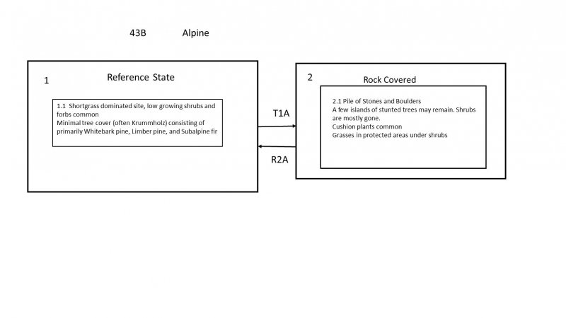
Click on box and path labels to scroll to the respective text.


