Natural Resources
Conservation Service
Ecological site R043BP818MT
Upland Grassland Group
Last updated: 5/15/2025
Accessed: 02/07/2026
General information
Provisional. A provisional ecological site description has undergone quality control and quality assurance review. It contains a working state and transition model and enough information to identify the ecological site.
MLRA notes
Major Land Resource Area (MLRA): 043B–Central Rocky Mountains
The Central Rocky Mountains (MLRA 43B) of Montana occupy some 28,850 square miles and exist primarily in Central and SW portions of the state. The climate is extremely variable with precipitation lows of 9 to 100 inches per year and frost free days of less than 30 to over 110 days. The geology of the region is also highly variable. The combination of variable climate and geology create a complex relationship of plant communities. MLRA 43B elevations typically exist between 6000 and 12,799ft at Granite Peak (the highest point in Montana).
The Continental Divide runs through this MLRA effectively splitting its watershed to contribute to either the Missouri River to the East and the Columbia River to the West.
Ecological site concept
• Site does not receive any additional water
• Soils are
o Generally not saline or saline-sodic (limited extent)
o Moderately deep, deep, or very deep
o Typically less than 5% stone and boulder cover (<15% max)
• Soil surface texture ranges from sandy loam to clay loam in surface mineral 4”
• Area of rugged mountain, hills, plateaus, and valleys of the Central Rocky Mountains in Southwest Montana.
• Moisture Regime: ustic to udic
• Temperature Regime: frigid to cryic
• Dominant Cover: rangeland (grass dominated)
• Elevation Range: 3800-10000ft
• Slope: 0-60% (typically less than 35%)
Associated sites
| R043BP810MT |
Shallow Grassland Group The Shallow Grassland is a neighboring site that exists higher on the landscape. The Shallow Grassland and the Upland Grassland share similar plant communities and state and transition models however, the Upland Grassland Site will produce higher amounts annual production. |
|---|---|
| R043BP811MT |
Shallow Sagebrush Shrubland Group The Shallow Sagebrush Shrubland is a neighboring site that exists higher on the landscape. The Shallow Sagebrush Shrubland and the Upland Grassland have some species overlap and state and transition models however, the Upland Grassland Site will produce higher amounts annual production. |
| R043BP819MT |
Upland Sagebrush Shrubland Group The Upland Sagebrush Shrubland occupies the same landscape position and is often intermixed with the Upland Grassland. The two sites will have significant plant community overlap and have similar state and transition models. |
| R043BP820MT |
Upland Shrubland Group The Upland Shrubland occupies the same landscape position and is often intermixed with the Upland Grassland. The two sites will have significant plant community overlap and have similar state and transition models. |
Similar sites
| R043BP810MT |
Shallow Grassland Group The Shallow Grassland is a neighboring site that exists higher on the landscape. The Shallow Grassland and the Upland Grassland share similar plant communities and state and transition models however, the Upland Grassland Site will produce higher amounts annual production. |
|---|---|
| R043BP811MT |
Shallow Sagebrush Shrubland Group The Shallow Sagebrush Shrubland is a neighboring site that exists higher on the landscape. The Shallow Sagebrush Shrubland and the Upland Grassland have some species overlap and state and transition models however, the Upland Grassland Site will produce higher amounts annual production. |
| R043BP819MT |
Upland Sagebrush Shrubland Group The Upland Sagebrush Shrubland occupies the same landscape position and is often intermixed with the Upland Grassland. The two sites will have significant plant community overlap and have similar state and transition models. |
| R043BP820MT |
Upland Shrubland Group The Upland Shrubland occupies the same landscape position and is often intermixed with the Upland Grassland. The two sites will have significant plant community overlap and have similar state and transition models. |
Table 1. Dominant plant species
| Tree |
Not specified |
|---|---|
| Shrub |
(1) Symphoricarpos albus |
| Herbaceous |
(1) Pseudoroegneria spicata |
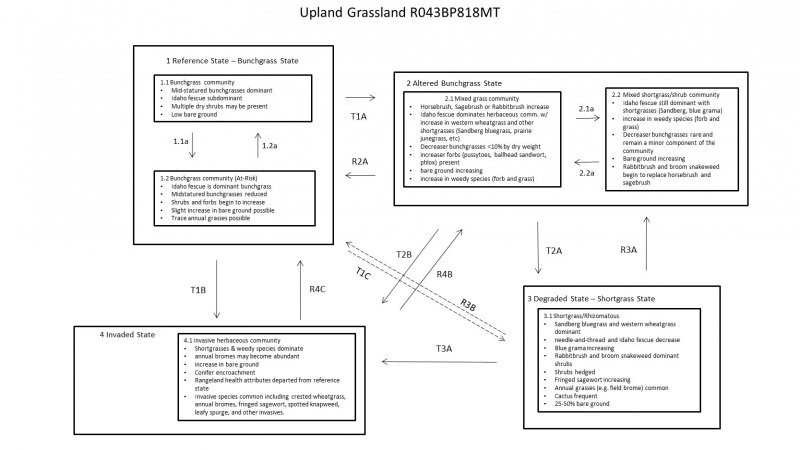
Click on box and path labels to scroll to the respective text.

